Bridge Statistics for Joppatowne, Maryland (MD)
Condition, Traffic, Stress, Structural Evaluation, Project Costs
- National Bridge Inventory (NBI) Statistics
- 13Number of bridges
- 207ft / 62.8mTotal length
- $1,501,000Total costs
- 408,254Total average daily traffic
- 38,185Total average daily truck traffic
- National Bridge Inventory (NBI) Registered Bridges for Joppatowne
- No street view available for this location
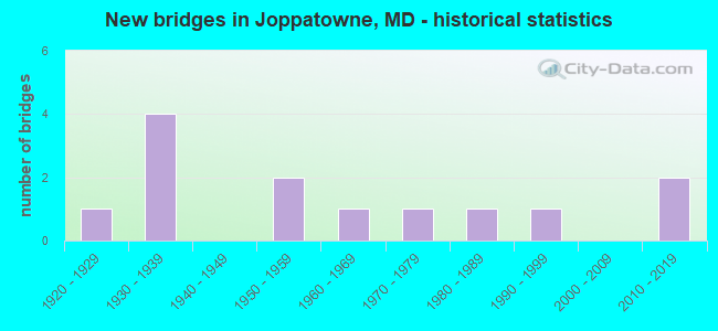
- New bridges - historical statistics
- 11920-1929
- 41930-1939
- 21950-1959
- 11960-1969
- 11970-1979
- 11980-1989
- 11990-1999
- 22010-2019

- Reconstructed bridges - Historical Statistics
- 11960-1969
- 01970-1979
- 01980-1989
- 01990-1999
- 02000-2009
- 02010-2019
- 12020-2022


- Bridge Condition - Deck
- 20.0%Excellent
- 30.0%Satisfactory
- 30.0%Fair
- 20.0%Poor

- Bridge Condition - Superstructure
- 20.0%Excellent
- 10.0%Good
- 20.0%Satisfactory
- 50.0%Fair

- Bridge Condition - Substructure
- 20.0%Excellent
- 30.0%Satisfactory
- 50.0%Fair

- Bridge Condition - Channel
- 11.1%Very good
- 33.3%Good
- 22.2%Satisfactory
- 33.3%Fair
Find on map >> Show street view
Structure Number: 10000003001201, Location: ON HARFORD CO LINE (Lat: 39.424256, Lng: -76.377778), Route carried "on" structure: State highway 7, Year Built: 1928, Status: Open, Structure Length: 3.17m (10.40ft), Average Daily Traffic: 8,520 (year 2009), Truck Traffic: 8%, Average Future Daily Traffic: 8,636 (year 2026), Features Intersected: LITTLE GUNPOWDER FALLS
Minimum Vertical Clearance: 30+ m (98+ ft), Kilometerpoint: 18.520, Lanes on structure: 2, Owner: State Highway Agency, Approaching Roadway Width: 8.5m (27.9ft), Material/Design: Concrete, Design/Construction: Arch - Deck, Number Of Spans In Main Unit: 2, Length of Maximum Span: 13.7m (44.9ft), Curb-To-Curb Width: 7.3m (24.0ft), Out-to-Out Width: 8.2m (26.9ft)
Condition: Deck: Fair, Superstructure: Fair, Substructure: Fair, Channel: Satisfactory, Operating Rating: 64.9 metric tons, Method Used To Determine Operating Rating: Load Factor (LF), Inventory Rating: 38.5 metric tons, Method Used To Determine Inventory Rating: Load Factor (LF), Structural Evaluation: Somewhat better than minimum adequacy, Deck Geometry: High priority of replacement, Waterway Adequacy: Superior to present desirable criteria, Approach Roadway Alignment: Equal to present desirable criteria, Length Of Structure Improvement: 3.17m (10.40ft), Designated Inspection Frequency: Every 12 months, Inspection Date: December 2021, Bridge Improvement Cost: $168,000, Roadway Improvement Cost: $17,000, Total Project Cost: $185,000, Deck Structure Type: Concrete Cast-file-Place, Wearing Surface/Protective System: Wearing Surface: Bituminous
Find on map >> Show street view
Structure Number: 100000030034013, Location: ON HARFORD CO LINE (Lat: 39.421283, Lng: -76.373628), Route carried "on" structure: US 40, Year Built: 1935, Status: Open, Structure Length: 3.02m (9.91ft), Average Daily Traffic: 14,156 (year 2012), Truck Traffic: 8%, Average Future Daily Traffic: 18,403 (year 2032), Design Load: H 20, Features Intersected: LITTLE GUNPOWDER FALLS
Minimum Vertical Clearance: 30+ m (98+ ft), Kilometerpoint: 41.137, Lanes on structure: 2, Base Highway Network: Yes, Owner: State Highway Agency, Approaching Roadway Width: 10.4m (34.1ft), Material/Design: Concrete, Design/Construction: Tee Beam, Number Of Spans In Main Unit: 2, Length of Maximum Span: 13.7m (44.9ft), Curb-To-Curb Width: 9.1m (29.9ft), Out-to-Out Width: 10.3m (33.8ft)
Condition: Deck: Poor, Superstructure: Fair, Substructure: Fair, Channel: Satisfactory, Inventory Rating: 65.3 metric tons, Method Used To Determine Inventory Rating: Load Factor (LF), Structural Evaluation: Somewhat better than minimum adequacy, Deck Geometry: Meets minimum limits, Waterway Adequacy: Equal to present minimum criteria, Approach Roadway Alignment: Equal to present desirable criteria, Length Of Structure Improvement: 3.02m (9.91ft), Designated Inspection Frequency: Every 12 months, Inspection Date: April 2021, Bridge Improvement Cost: $201,000, Roadway Improvement Cost: $20,000, Total Project Cost: $221,000, Deck Structure Type: Concrete Cast-file-Place, Wearing Surface/Protective System: Wearing Surface: Monolithic Concrete
Find on map >> Show street view
Structure Number: 100000030034014, Location: ON HARFORD CO LINE (Lat: 39.421578, Lng: -76.373506), Route carried "on" structure: US 40, Year Built: 1935, Status: Open, Structure Length: 3.02m (9.91ft), Average Daily Traffic: 12,533 (year 2012), Truck Traffic: 8%, Average Future Daily Traffic: 16,319 (year 2032), Design Load: H 20, Features Intersected: LITTLE GUNPOWDER FALLS
Minimum Vertical Clearance: 30+ m (98+ ft), Kilometerpoint: 41.137, Lanes on structure: 2, Base Highway Network: Yes, Owner: State Highway Agency, Approaching Roadway Width: 10.4m (34.1ft), Material/Design: Concrete, Design/Construction: Tee Beam, Number Of Spans In Main Unit: 2, Length of Maximum Span: 13.7m (44.9ft), Curb-To-Curb Width: 9.1m (29.9ft), Out-to-Out Width: 10.3m (33.8ft)
Condition: Deck: Poor, Superstructure: Fair, Substructure: Satisfactory, Channel: Fair, Inventory Rating: 65.3 metric tons, Method Used To Determine Inventory Rating: Load Factor (LF), Structural Evaluation: Somewhat better than minimum adequacy, Deck Geometry: Meets minimum limits, Waterway Adequacy: Equal to present minimum criteria, Approach Roadway Alignment: Equal to present desirable criteria, Length Of Structure Improvement: 3.02m (9.91ft), Designated Inspection Frequency: Every 12 months, Inspection Date: April 2021, Bridge Improvement Cost: $201,000, Roadway Improvement Cost: $20,000, Total Project Cost: $221,000, Deck Structure Type: Concrete Cast-file-Place, Wearing Surface/Protective System: Wearing Surface: Monolithic Concrete
Find on map >> Show street view
Structure Number: 100000030035013, Location: 0.31 MI W OF JONES RD (Lat: 39.408622, Lng: -76.390231), Route carried "on" structure: US 40, Year Built: 1935, Status: Open, Structure Length: 5.97m (19.59ft), Average Daily Traffic: 14,156 (year 2012), Truck Traffic: 8%, Average Future Daily Traffic: 16,987 (year 2032), Design Load: H 20, Features Intersected: GUNPOWDER FALLS
Minimum Vertical Clearance: 30+ m (98+ ft), Kilometerpoint: 39.118, Lanes on structure: 2, Base Highway Network: Yes, Owner: State Highway Agency, Approaching Roadway Width: 13.4m (44.0ft), Skew: 2 degrees, Material/Design: Steel, Design/Construction: Stringer/Multi-beam, Number Of Spans In Main Unit: 3, Length of Maximum Span: 19.8m (65.0ft), Curb-To-Curb Width: 9.1m (29.9ft), Out-to-Out Width: 10.3m (33.8ft)
Condition: Deck: Fair, Superstructure: Fair, Substructure: Fair, Channel: Fair, Operating Rating: 61.2 metric tons, Method Used To Determine Operating Rating: Load Factor (LF), Inventory Rating: 36.7 metric tons, Method Used To Determine Inventory Rating: Load Factor (LF), Structural Evaluation: Somewhat better than minimum adequacy, Deck Geometry: Meets minimum limits, Waterway Adequacy: Better than present minimum criteria, Approach Roadway Alignment: Equal to present desirable criteria, Length Of Structure Improvement: 5.97m (19.59ft), Designated Inspection Frequency: Every 24 months, Underwater Inspection Frequency: Every 48 months, Inspection Date: April 2020, Underwater Inspection Date: April 2020, Bridge Improvement Cost: $397,000, Roadway Improvement Cost: $40,000, Total Project Cost: $437,000, Deck Structure Type: Concrete Cast-file-Place, Wearing Surface/Protective System: Wearing Surface: Monolithic Concrete
Find on map >> Show street view
Structure Number: 100000030035014, Location: 0.31 MI W OF JONES RD (Lat: 39.409144, Lng: -76.389814), Route carried "on" structure: US 40, Year Built: 1935, Status: Open, Structure Length: 5.97m (19.59ft), Average Daily Traffic: 12,553 (year 2012), Truck Traffic: 8%, Average Future Daily Traffic: 15,064 (year 2032), Design Load: H 20, Features Intersected: GUNPOWDER FALLS
Minimum Vertical Clearance: 30+ m (98+ ft), Kilometerpoint: 39.118, Lanes on structure: 2, Base Highway Network: Yes, Owner: State Highway Agency, Approaching Roadway Width: 13.4m (44.0ft), Skew: 2 degrees, Material/Design: Steel, Design/Construction: Stringer/Multi-beam, Number Of Spans In Main Unit: 3, Length of Maximum Span: 19.8m (65.0ft), Curb-To-Curb Width: 9.1m (29.9ft), Out-to-Out Width: 10.3m (33.8ft)
Condition: Deck: Fair, Superstructure: Fair, Substructure: Fair, Channel: Fair, Operating Rating: 61.2 metric tons, Method Used To Determine Operating Rating: Load Factor (LF), Inventory Rating: 36.7 metric tons, Method Used To Determine Inventory Rating: Load Factor (LF), Structural Evaluation: Somewhat better than minimum adequacy, Deck Geometry: Meets minimum limits, Waterway Adequacy: Equal to present desirable criteria, Approach Roadway Alignment: Equal to present desirable criteria, Length Of Structure Improvement: 5.97m (19.59ft), Designated Inspection Frequency: Every 24 months, Underwater Inspection Frequency: Every 48 months, Inspection Date: April 2020, Underwater Inspection Date: April 2020, Bridge Improvement Cost: $397,000, Roadway Improvement Cost: $40,000, Total Project Cost: $437,000, Deck Structure Type: Concrete Cast-file-Place, Wearing Surface/Protective System: Wearing Surface: Monolithic Concrete
Find on map >> Show street view
Structure Number: 200000H-016301, Location: 0.05 MI S OF TOWNE CNT DR (Lat: 39.410550, Lng: -76.360550), Route carried "on" structure: County highway 934, Year Built: 1975, Status: Open, Structure Length: 6.55m (21.49ft), Average Daily Traffic: 1,326 (year 2019), Truck Traffic: 5%, Average Future Daily Traffic: 1,618 (year 2039), Design Load: H 20, Features Intersected: JOPPATOWNE CANAL, Facility Carried by Structure: BRIDGE DRIVE
Minimum Vertical Clearance: 30+ m (98+ ft), Kilometerpoint: 0.080, Lanes on structure: 2, Owner: County Highway Agency, Approaching Roadway Width: 7.3m (24.0ft), Navigation Control: Yes ( Vertical Clearance: 4.6m (15.1ft), Horizontal Clearance: 20.4m (66.9ft)), Material/Design: Steel, Design/Construction: Stringer/Multi-beam, Number Of Spans In Main Unit: 3, Length of Maximum Span: 21.3m (69.9ft), Curb or Sidewalk Widths: Left: 0.2m (0.7ft), Right: 1.8m (5.9ft), Curb-To-Curb Width: 7.3m (24.0ft), Out-to-Out Width: 10.0m (32.8ft)
Condition: Deck: Satisfactory, Superstructure: Good, Substructure: Fair, Channel: Very good, Operating Rating: 75.3 metric tons, Method Used To Determine Operating Rating: Load Factor (LF), Inventory Rating: 45.4 metric tons, Method Used To Determine Inventory Rating: Load Factor (LF), Structural Evaluation: Somewhat better than minimum adequacy, Deck Geometry: Meets minimum limits, Waterway Adequacy: Superior to present desirable criteria, Approach Roadway Alignment: Meets minimum limits, Designated Inspection Frequency: Every 24 months, Underwater Inspection Frequency: Every 48 months, Inspection Date: December 2021, Underwater Inspection Date: December 2019, Deck Structure Type: Concrete Cast-file-Place, Wearing Surface/Protective System: Wearing Surface: Monolithic Concrete
Find on map >> Show street view
Structure Number: 200000H-018401, Location: 0.3 MILES N OF MD 7 (Lat: 39.435028, Lng: -76.371333), Route carried "on" structure: County highway 2051, Year Built: 1985, Status: Open, Structure Length: 0.73m (2.40ft), Average Daily Traffic: 101 (year 2019), Truck Traffic: 5%, Average Future Daily Traffic: 202 (year 2039), Features Intersected: TRIBUTARY TO LITTLE GUNP, Facility Carried by Structure: MANDEVILLE ROAD
Minimum Vertical Clearance: 30+ m (98+ ft), Kilometerpoint: 0.595, Lanes on structure: 1, Owner: County Highway Agency, Approaching Roadway Width: 4.3m (14.1ft), Skew: 1 degrees, Material/Design: Steel, Design/Construction: Culvert, Number Of Spans In Main Unit: 1, Length of Maximum Span: 7.3m (24.0ft), Curb or Sidewalk Widths: Left: 0.3m (1.0ft), Right: 0.3m (1.0ft)
Condition: Channel: Good, Culverts: Good, Operating Rating: 85.7 metric tons, Method Used To Determine Operating Rating: Load Factor (LF), Inventory Rating: 51.2 metric tons, Method Used To Determine Inventory Rating: Load Factor (LF), Structural Evaluation: Better than present minimum criteria, Waterway Adequacy: Better than present minimum criteria, Approach Roadway Alignment: Equal to present desirable criteria, Designated Inspection Frequency: Every 24 months, Inspection Date: July 2021
Find on map >> Show street view
Structure Number: 200000H-020102, Location: 1.9 MILES E OF US 40 (Lat: 39.405825, Lng: -76.344675), Route carried "on" structure: County highway 508, Year Built: 1997, Status: Open, Structure Length: 0.79m (2.59ft), Average Daily Traffic: 5,413 (year 2019), Truck Traffic: 5%, Average Future Daily Traffic: 6,389 (year 2039), Design Load: HS 25 or greater, Features Intersected: FOSTER BRANCH, Facility Carried by Structure: JOPPA FARM ROAD
Minimum Vertical Clearance: 30+ m (98+ ft), Kilometerpoint: 0.000, Lanes on structure: 2, Owner: County Highway Agency, Approaching Roadway Width: 11.0m (36.1ft), Material/Design: Concrete, Design/Construction: Culvert, Length of Maximum Span: 3.7m (12.1ft)
Condition: Channel: Good, Culverts: Good, Structural Evaluation: Better than present minimum criteria, Waterway Adequacy: Superior to present desirable criteria, Approach Roadway Alignment: Equal to present desirable criteria, Designated Inspection Frequency: Every 24 months, Inspection Date: July 2021
Find on map >> Show street view
Structure Number: 300000B-X71701, Location: Milepost M71.7 (Lat: 39.427747, Lng: -76.388581), Route carried "on" structure: County highway 3927, Year Built: 1959, Year Reconstructed: 2020, Status: Open, Structure Length: 9.75m (31.99ft), Average Daily Traffic: 2,590 (year 2019), Truck Traffic: 1%, Average Future Daily Traffic: 3,086 (year 2041), Features Intersected: I-95, Facility Carried by Structure: BRADSHAW ROAD
Minimum Vertical Clearance: 30+ m (98+ ft), Kilometerpoint: 115.414, Lanes on structure: 2, Lanes under structure: 8, Owner: State Toll Authority, Approaching Roadway Width: 9.1m (29.9ft), Skew: 2 degrees, Material/Design: Steel, Design/Construction: Stringer/Multi-beam, Length of Maximum Span: 48.8m (160.1ft), Curb or Sidewalk Widths: Left: 1.6m (5.2ft), Right: 1.6m (5.2ft), Curb-To-Curb Width: 9.1m (29.9ft), Out-to-Out Width: 10.4m (34.1ft)
Condition: Deck: Excellent, Superstructure: Excellent, Substructure: Excellent, Operating Rating: 54.1 metric tons, Method Used To Determine Operating Rating: Load and Resistance Factor Rating (LRFR) rating reported by rating factor(RF) method using HL-93 loadings, Inventory Rating: 41.8 metric tons, Method Used To Determine Inventory Rating: Load and Resistance Factor Rating (LRFR) rating reported by rating factor(RF) method using HL-93 loadings, Structural Evaluation: Superior to present desirable criteria, Deck Geometry: Meets minimum limits, Underclear: Equal to present minimum criteria, Approach Roadway Alignment: Equal to present desirable criteria, Designated Inspection Frequency: Every 24 months, Inspection Date: Febuary 2020, Deck Structure Type: Concrete Cast-file-Place, Wearing Surface/Protective System: Wearing Surface: Integral Concrete
Find on map >> Show street view
Structure Number: 300000B-X72601, Location: BALT-HAR CO LINE (Lat: 39.435228, Lng: -76.378539), Route carried "on" structure: Interstate 95, Year Built: 1959, Year Reconstructed: 1971, Status: Open, Structure Length: 6.46m (21.19ft), Average Daily Traffic: 178,830 (year 2019), Truck Traffic: 8%, Average Future Daily Traffic: 250,841 (year 2041), Design Load: HS 20, Features Intersected: LITTLE GUNPOWDER FALLS
Minimum Vertical Clearance: 30+ m (98+ ft), Kilometerpoint: 116.749, Lanes on structure: 8, Base Highway Network: Yes, Owner: State Toll Authority, Approaching Roadway Width: 43.9m (144.0ft), Skew: 31 degrees, Material/Design: Steel, Design/Construction: Stringer/Multi-beam, Number Of Spans In Main Unit: 3, Length of Maximum Span: 32.0m (105.0ft), Curb-To-Curb Width: 44.1m (144.7ft), Out-to-Out Width: 46.2m (151.6ft)
Condition: Deck: Satisfactory, Superstructure: Satisfactory, Substructure: Satisfactory, Channel: Good, Operating Rating: 72.1 metric tons, Method Used To Determine Operating Rating: Load Factor (LF), Inventory Rating: 43.1 metric tons, Method Used To Determine Inventory Rating: Load Factor (LF), Structural Evaluation: Equal to present minimum criteria, Deck Geometry: Superior to present desirable criteria, Waterway Adequacy: Superior to present desirable criteria, Approach Roadway Alignment: Better than present minimum criteria, Designated Inspection Frequency: Every 24 months, Inspection Date: October 2021, Deck Structure Type: Concrete Cast-file-Place, Wearing Surface/Protective System: Wearing Surface: Latex Concrete
Find on map >> Show street view
Structure Number: 300000H-X73401, Location: Milepost M73.4 (Lat: 39.442403, Lng: -76.365022), Route carried "on" structure: County highway 260, Year Built: 2019, Status: Open, Structure Length: 10.25m (33.63ft), Average Daily Traffic: 3,330 (year 2018), Truck Traffic: 3%, Average Future Daily Traffic: 3,840 (year 2034), Features Intersected: I-95, Facility Carried by Structure: OLD JOPPA ROAD
Minimum Vertical Clearance: 30+ m (98+ ft), Kilometerpoint: 118.101, Lanes on structure: 2, Lanes under structure: 8, Owner: State Toll Authority, Approaching Roadway Width: 9.1m (29.9ft), Skew: 2 degrees, Material/Design: Steel continuous, Design/Construction: Stringer/Multi-beam, Number Of Spans In Main Unit: 2, Length of Maximum Span: 26.5m (86.9ft), Curb or Sidewalk Widths: Left: 1.2m (3.9ft), Right: 1.2m (3.9ft), Curb-To-Curb Width: 9.1m (29.9ft), Out-to-Out Width: 10.4m (34.1ft)
Condition: Deck: Excellent, Superstructure: Excellent, Substructure: Excellent, Operating Rating: 47.6 metric tons, Method Used To Determine Operating Rating: Load and Resistance Factor Rating (LRFR) rating reported by rating factor(RF) method using HL-93 loadings, Inventory Rating: 36.9 metric tons, Method Used To Determine Inventory Rating: Load and Resistance Factor Rating (LRFR) rating reported by rating factor(RF) method using HL-93 loadings, Structural Evaluation: Superior to present desirable criteria, Deck Geometry: Meets minimum limits, Underclear: Equal to present minimum criteria, Approach Roadway Alignment: Better than present minimum criteria, Designated Inspection Frequency: Every 24 months, Inspection Date: January 2021, Deck Structure Type: Concrete Cast-file-Place, Wearing Surface/Protective System: Wearing Surface: Integral Concrete
Find on map >> Show street view
Structure Number: 300000H-X74201, Location: Milepost M74.2 (Lat: 39.442344, Lng: -76.350494), Route carried "on" structure: County highway 922, Year Built: 1963, Status: Open, Structure Length: 7.10m (23.29ft), Average Daily Traffic: 1,521 (year 2019), Truck Traffic: 5%, Average Future Daily Traffic: 1,894 (year 2041), Design Load: HS 20, Features Intersected: I-95, Facility Carried by Structure: OLD MOUNTAIN RD
Minimum Vertical Clearance: 30+ m (98+ ft), Kilometerpoint: 119.388, Lanes on structure: 2, Lanes under structure: 8, Owner: State Toll Authority, Approaching Roadway Width: 12.8m (42.0ft), Skew: 1 degrees, Material/Design: Steel, Design/Construction: Stringer/Multi-beam, Number Of Spans In Main Unit: 4, Length of Maximum Span: 23.5m (77.1ft), Curb or Sidewalk Widths: Left: 1.6m (5.2ft), Right: 1.6m (5.2ft), Curb-To-Curb Width: 9.1m (29.9ft), Out-to-Out Width: 12.9m (42.3ft)
Condition: Deck: Satisfactory, Superstructure: Satisfactory, Substructure: Satisfactory, Operating Rating: 80.7 metric tons, Method Used To Determine Operating Rating: Load Factor (LF), Inventory Rating: 48.5 metric tons, Method Used To Determine Inventory Rating: Load Factor (LF), Structural Evaluation: Equal to present minimum criteria, Deck Geometry: Somewhat better than minimum adequacy, Underclear: Somewhat better than minimum adequacy, Approach Roadway Alignment: Equal to present desirable criteria, Designated Inspection Frequency: Every 24 months, Inspection Date: October 2021, Deck Structure Type: Concrete Cast-file-Place, Wearing Surface/Protective System: Wearing Surface: Latex Concrete
Find on map >> Show street view
Structure Number: 300000H-X73401, Location: Milepost M73.4 (Lat: 39.442403, Lng: -76.365022), Route carried "under" structure: Interstate 95, Year Built: 2019, Structure Length: 0. m, Average Daily Traffic: 153,225 (year 2018), Truck Traffic: 12%, Features Intersected: IS 95, Facility Carried by Structure: CO0260
Minimum Vertical Clearance: 5.49m (18.01ft), Kilometerpoint: 1.287, Lanes on structure: 2, Lanes under structure: 8, Material/Design: Steel continuous, Design/Construction: Stringer/Multi-beam, Length of Maximum Span: 26.5m (86.9ft)