Bridge Statistics for Jefferson Hills, Pennsylvania (PA)
Condition, Traffic, Stress, Structural Evaluation, Project Costs
- National Bridge Inventory (NBI) Statistics
- 36Number of bridges
- 367ft / 112mTotal length
- $1,572,000Total costs
- 240,907Total average daily traffic
- 16,811Total average daily truck traffic
- National Bridge Inventory (NBI) Registered Bridges for Jefferson Hills
- No street view available for this location
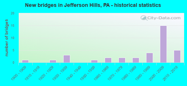
- New bridges - historical statistics
- 11900-1909
- 11920-1929
- 31930-1939
- 11950-1959
- 21960-1969
- 21970-1979
- 21980-1989
- 41990-1999
- 152000-2009
- 52010-2019

- Reconstructed bridges - Historical Statistics
- 21990-1999
- 22000-2009
- 22010-2019


- Bridge Condition - Deck
- 8.3%Excellent
- 8.3%Very good
- 58.3%Good
- 16.7%Satisfactory
- 8.3%Fair

- Bridge Condition - Superstructure
- 6.7%Excellent
- 26.7%Very good
- 26.7%Good
- 20.0%Satisfactory
- 13.3%Fair
- 6.7%Poor

- Bridge Condition - Substructure
- 6.7%Excellent
- 40.0%Good
- 33.3%Satisfactory
- 20.0%Fair

- Bridge Condition - Channel
- 19.0%Very good
- 23.8%Good
- 23.8%Satisfactory
- 23.8%Fair
- 9.5%Poor

- Bridge Condition - Culverts
- 22.2%Very good
- 44.4%Good
- 33.3%Satisfactory
Find on map >> Show street view
Structure Number: 725, Location: ONE MILE N OF SR 2030 (Lat: 40.303986, Lng: -79.932697), Route carried "on" structure: State highway 51, Year Built: 1960, Year Reconstructed: 1999, Status: Open, Structure Length: 0.85m (2.79ft), Average Daily Traffic: 26,310 (year 2022), Truck Traffic: 8%, Average Future Daily Traffic: 34,275 (year 2032), Design Load: HS 20, Features Intersected: OVER LEWIS RUN
Minimum Vertical Clearance: 30+ m (98+ ft), Kilometerpoint: 14.869, Lanes on structure: 5, Base Highway Network: Yes, Owner: State Highway Agency, Approaching Roadway Width: 19.5m (64.0ft), Skew: 33 degrees, Material/Design: Concrete, Design/Construction: Culvert, Number Of Spans In Main Unit: 1, Length of Maximum Span: 8.5m (27.9ft)
Condition: Channel: Fair, Culverts: Satisfactory, Operating Rating: 49.0 metric tons, Method Used To Determine Operating Rating: Field evaluation and documented engineering judgment, Inventory Rating: 32.7 metric tons, Method Used To Determine Inventory Rating: Field evaluation and documented engineering judgment, Structural Evaluation: Equal to present minimum criteria, Waterway Adequacy: Equal to present minimum criteria, Approach Roadway Alignment: Equal to present desirable criteria, Length Of Structure Improvement: 0.90m (2.95ft), Designated Inspection Frequency: Every 24 months, Inspection Date: December 2019, Bridge Improvement Cost: $10,000, Roadway Improvement Cost: $35,000, Total Project Cost: $132,000
Find on map >> Show street view
Structure Number: 728, Location: 100 FT SO COAL VALLEY RD (Lat: 40.312792, Lng: -79.938439), Route carried "on" structure: State highway 51, Year Built: 1935, Year Reconstructed: 1999, Status: Open, Structure Length: 0.88m (2.89ft), Average Daily Traffic: 26,310 (year 2022), Truck Traffic: 8%, Average Future Daily Traffic: 34,275 (year 2032), Design Load: HS 20, Features Intersected: LEWIS RUN, Facility Carried by Structure: CLAIRTON BLVD
Minimum Vertical Clearance: 30+ m (98+ ft), Kilometerpoint: 15.783, Lanes on structure: 4, Base Highway Network: Yes, Owner: State Highway Agency, Approaching Roadway Width: 19.5m (64.0ft), Skew: 23 degrees, Material/Design: Concrete, Design/Construction: Culvert, Number Of Spans In Main Unit: 1, Length of Maximum Span: 7.9m (25.9ft), Curb-To-Curb Width: 19.5m (64.0ft), Out-to-Out Width: 20.1m (65.9ft)
Condition: Channel: Fair, Culverts: Satisfactory, Operating Rating: 49.0 metric tons, Method Used To Determine Operating Rating: Field evaluation and documented engineering judgment, Inventory Rating: 32.7 metric tons, Method Used To Determine Inventory Rating: Field evaluation and documented engineering judgment, Structural Evaluation: Equal to present minimum criteria, Deck Geometry: Better than present minimum criteria, Waterway Adequacy: Superior to present desirable criteria, Approach Roadway Alignment: Equal to present desirable criteria, Length Of Structure Improvement: 1.50m (4.92ft), Designated Inspection Frequency: Every 24 months, Inspection Date: December 2019
Find on map >> Show street view
Structure Number: 1723, Location: .5 MI.NORTHWEST SR 2028 (Lat: 40.280033, Lng: -79.954078), Route carried "on" structure: State highway , Year Built: 1956, Year Reconstructed: 2019, Status: Open, Structure Length: 1.77m (5.81ft), Average Daily Traffic: 3,294 (year 2022), Truck Traffic: 5%, Average Future Daily Traffic: 4,822 (year 2032), Design Load: HL 93, Features Intersected: PETERS CREEK, Facility Carried by Structure: GILL HALL RD
Minimum Vertical Clearance: 30+ m (98+ ft), Kilometerpoint: 1.324, Lanes on structure: 2, Owner: State Highway Agency, Approaching Roadway Width: 7.3m (24.0ft), Skew: 1 degrees, Material/Design: Steel, Design/Construction: Stringer/Multi-beam, Number Of Spans In Main Unit: 1, Length of Maximum Span: 17.1m (56.1ft), Curb-To-Curb Width: 7.5m (24.6ft), Out-to-Out Width: 8.1m (26.6ft)
Condition: Deck: Very good, Superstructure: Very good, Substructure: Good, Channel: Satisfactory, Operating Rating: 66.7 metric tons, Method Used To Determine Operating Rating: Assigned ratings based on Load and Resistance Factor Design (LRFD) reported by rating factor (RF) using HL93 loadings, Inventory Rating: 51.2 metric tons, Method Used To Determine Inventory Rating: Assigned ratings based on Load and Resistance Factor Design (LRFD) reported by rating factor (RF) using HL93 loadings, Structural Evaluation: Better than present minimum criteria, Deck Geometry: High priority of replacement, Waterway Adequacy: Equal to present minimum criteria, Approach Roadway Alignment: Equal to present minimum criteria, Length Of Structure Improvement: 1.70m (5.58ft), Designated Inspection Frequency: Every 24 months, Inspection Date: May 2021, Bridge Improvement Cost: $11,000, Roadway Improvement Cost: $34,000, Total Project Cost: $153,000, Deck Structure Type: Concrete Cast-file-Place, Wearing Surface/Protective System: Wearing Surface: Monolithic Concrete, Deck Protection: Epoxy Coated Reinforcing
Find on map >> Show street view
Structure Number: 1724, Location: 0.5 MI S BUREAU OF MINES (Lat: 40.292936, Lng: -79.970186), Route carried "on" structure: State highway , Year Built: 1901, Status: Open, Structure Length: 0.73m (2.40ft), Average Daily Traffic: 618 (year 2022), Truck Traffic: 5%, Average Future Daily Traffic: 5,476 (year 2032), Design Load: HS 20, Features Intersected: LICK RUN CREEK, Facility Carried by Structure: COCHRANS MILLS RD
Minimum Vertical Clearance: 30+ m (98+ ft), Kilometerpoint: 2.882, Lanes on structure: 2, Owner: State Highway Agency, Approaching Roadway Width: 9.1m (29.9ft), Material/Design: Masonry, Design/Construction: Arch - Deck, Number Of Spans In Main Unit: 1, Length of Maximum Span: 7.3m (24.0ft), Curb-To-Curb Width: 4.9m (16.1ft), Out-to-Out Width: 5.9m (19.4ft)
Condition: Superstructure: Poor, Substructure: Satisfactory, Channel: Fair, Operating Rating: 49.0 metric tons, Method Used To Determine Operating Rating: Field evaluation and documented engineering judgment, Inventory Rating: 32.7 metric tons, Method Used To Determine Inventory Rating: Field evaluation and documented engineering judgment, Structural Evaluation: Meets minimum limits, Deck Geometry: High priority of replacement, Waterway Adequacy: Equal to present minimum criteria, Approach Roadway Alignment: Equal to present desirable criteria, Length Of Structure Improvement: 1.60m (5.25ft), Designated Inspection Frequency: Every 24 months, Other Special Inspection Frequency: Every 12 months, Inspection Date: March 2020, Other Special Inspection Date: March 2021, Bridge Improvement Cost: $2,000, Roadway Improvement Cost: $7,000, Total Project Cost: $30,000
Find on map >> Show street view
Structure Number: 1726, Location: 1450' S.W. OF SR 3021 (Lat: 40.266303, Lng: -79.930194), Route carried "on" structure: State highway , Year Built: 1938, Status: Open, Structure Length: 0.70m (2.30ft), Average Daily Traffic: 408 (year 2022), Truck Traffic: 5%, Average Future Daily Traffic: 868 (year 2038), Design Load: HS 20, Features Intersected: LOBBS RUN, Facility Carried by Structure: SCHEINBACH RD
Minimum Vertical Clearance: 30+ m (98+ ft), Kilometerpoint: 0.000, Lanes on structure: 2, Owner: State Highway Agency, Approaching Roadway Width: 7.9m (25.9ft), Skew: 4 degrees, Material/Design: Concrete, Design/Construction: Tee Beam, Number Of Spans In Main Unit: 1, Length of Maximum Span: 6.1m (20.0ft), Curb-To-Curb Width: 7.0m (23.0ft), Out-to-Out Width: 8.0m (26.2ft)
Condition: Deck: Fair, Superstructure: Fair, Substructure: Fair, Channel: Poor, Operating Rating: 50.8 metric tons, Method Used To Determine Operating Rating: Load Factor (LF), Inventory Rating: 29.9 metric tons, Method Used To Determine Inventory Rating: Load Factor (LF), Structural Evaluation: Somewhat better than minimum adequacy, Deck Geometry: Meets minimum limits, Waterway Adequacy: Better than present minimum criteria, Approach Roadway Alignment: Equal to present desirable criteria, Length Of Structure Improvement: 0.70m (2.30ft), Designated Inspection Frequency: Every 24 months, Inspection Date: November 2019, Bridge Improvement Cost: $9,000, Roadway Improvement Cost: $25,000, Total Project Cost: $116,000, Deck Structure Type: Concrete Cast-file-Place, Wearing Surface/Protective System: Wearing Surface: Bituminous
Find on map >> Show street view
Structure Number: 173, Location: 1050' N.W. OF SR 0837 (Lat: 40.260667, Lng: -79.917678), Route carried "on" structure: State highway , Year Built: 1962, Status: Open, Structure Length: 1.22m (4.00ft), Average Daily Traffic: 538 (year 2021), Truck Traffic: 2%, Average Future Daily Traffic: 1,538 (year 2038), Design Load: HS 20, Features Intersected: LOBBS RUN, Facility Carried by Structure: WALTON ROAD
Minimum Vertical Clearance: 30+ m (98+ ft), Kilometerpoint: 0.000, Lanes on structure: 2, Owner: State Highway Agency, Approaching Roadway Width: 6.4m (21.0ft), Skew: 4 degrees, Material/Design: Concrete, Design/Construction: Tee Beam, Number Of Spans In Main Unit: 1, Length of Maximum Span: 10.7m (35.1ft), Curb or Sidewalk Widths: Left: 0.5m (1.6ft), Right: 0.5m (1.6ft), Curb-To-Curb Width: 11.6m (38.1ft), Out-to-Out Width: 13.4m (44.0ft)
Condition: Deck: Satisfactory, Superstructure: Satisfactory, Substructure: Fair, Channel: Fair, Operating Rating: 43.5 metric tons, Method Used To Determine Operating Rating: Load Factor (LF), Inventory Rating: 26.3 metric tons, Method Used To Determine Inventory Rating: Load Factor (LF), Structural Evaluation: Somewhat better than minimum adequacy, Deck Geometry: Better than present minimum criteria, Waterway Adequacy: Superior to present desirable criteria, Approach Roadway Alignment: Better than present minimum criteria, Length Of Structure Improvement: 1.20m (3.94ft), Designated Inspection Frequency: Every 24 months, Inspection Date: November 2019, Deck Structure Type: Concrete Cast-file-Place, Wearing Surface/Protective System: Wearing Surface: Bituminous
Find on map >> Show street view
Structure Number: 1731, Location: 0.5 MI. N.W. OF SR 0837 (Lat: 40.264903, Lng: -79.920053), Route carried "on" structure: State highway , Year Built: 1925, Status: Open, Structure Length: 0.91m (2.99ft), Average Daily Traffic: 538 (year 2021), Truck Traffic: 2%, Average Future Daily Traffic: 1,538 (year 2038), Design Load: HS 20, Features Intersected: LOBBS RUN, Facility Carried by Structure: WALTON RD.
Minimum Vertical Clearance: 30+ m (98+ ft), Kilometerpoint: 0.443, Lanes on structure: 2, Owner: State Highway Agency, Approaching Roadway Width: 6.4m (21.0ft), Skew: 6 degrees, Material/Design: Concrete, Design/Construction: Arch - Deck, Number Of Spans In Main Unit: 1, Length of Maximum Span: 9.1m (29.9ft), Curb-To-Curb Width: 6.9m (22.6ft), Out-to-Out Width: 7.6m (24.9ft)
Condition: Superstructure: Fair, Substructure: Fair, Channel: Fair, Operating Rating: 49.0 metric tons, Method Used To Determine Operating Rating: Field evaluation and documented engineering judgment, Inventory Rating: 32.7 metric tons, Method Used To Determine Inventory Rating: Field evaluation and documented engineering judgment, Structural Evaluation: Somewhat better than minimum adequacy, Deck Geometry: Meets minimum limits, Waterway Adequacy: Superior to present desirable criteria, Approach Roadway Alignment: Equal to present desirable criteria, Length Of Structure Improvement: 2.60m (8.53ft), Designated Inspection Frequency: Every 24 months, Inspection Date: November 2019, Bridge Improvement Cost: $63,000, Roadway Improvement Cost: $185,000, Total Project Cost: $848,000
Find on map >> Show street view
Structure Number: 1732, Location: 1/4 MI. S.E. OF SR 3018 (Lat: 40.267111, Lng: -79.923169), Route carried "on" structure: State highway , Year Built: 1938, Year Reconstructed: 2009, Status: Open, Structure Length: 1.04m (3.41ft), Average Daily Traffic: 538 (year 2021), Truck Traffic: 2%, Average Future Daily Traffic: 1,538 (year 2032), Design Load: HS 20, Features Intersected: LOBBS RUN, Facility Carried by Structure: WALTON ROAD
Minimum Vertical Clearance: 30+ m (98+ ft), Kilometerpoint: 1.162, Lanes on structure: 2, Owner: State Highway Agency, Approaching Roadway Width: 6.4m (21.0ft), Skew: 3 degrees, Material/Design: Concrete, Design/Construction: Slab, Number Of Spans In Main Unit: 1, Length of Maximum Span: 9.1m (29.9ft), Curb-To-Curb Width: 6.9m (22.6ft), Out-to-Out Width: 7.9m (25.9ft)
Condition: Deck: Good, Superstructure: Good, Substructure: Good, Channel: Satisfactory, Operating Rating: 70.8 metric tons, Method Used To Determine Operating Rating: Load Factor (LF), Inventory Rating: 41.7 metric tons, Method Used To Determine Inventory Rating: Load Factor (LF), Structural Evaluation: Better than present minimum criteria, Deck Geometry: Meets minimum limits, Waterway Adequacy: Better than present minimum criteria, Approach Roadway Alignment: Equal to present desirable criteria, Length Of Structure Improvement: 1.00m (3.28ft), Designated Inspection Frequency: Every 24 months, Inspection Date: November 2019, Bridge Improvement Cost: $9,000, Roadway Improvement Cost: $26,000, Total Project Cost: $120,000, Deck Structure Type: Concrete Cast-file-Place, Wearing Surface/Protective System: Wearing Surface: Monolithic Concrete, Deck Protection: Epoxy Coated Reinforcing
Find on map >> Show street view
Structure Number: 2295, Location: PG03 PANGBURN HOLLOW #3 (Lat: 40.245017, Lng: -79.911478), Route carried "on" structure: County highway , Year Built: 1978, Year Reconstructed: 2012, Status: Open, Structure Length: 0.82m (2.69ft), Average Daily Traffic: 715 (year 2010), Truck Traffic: 5%, Average Future Daily Traffic: 875 (year 2030), Design Load: HS 20, Features Intersected: PERRY MILL RUN, Facility Carried by Structure: PANGBURN HOLLOW RD
Minimum Vertical Clearance: 30+ m (98+ ft), Kilometerpoint: 0.000, Lanes on structure: 2, Owner: County Highway Agency, Approaching Roadway Width: 8.8m (28.9ft), Skew: 3 degrees, Material/Design: Concrete, Design/Construction: Slab, Number Of Spans In Main Unit: 1, Length of Maximum Span: 7.3m (24.0ft), Curb or Sidewalk Widths: Left: 0.2m (0.7ft), Right: 0.2m (0.7ft), Curb-To-Curb Width: 6.7m (22.0ft), Out-to-Out Width: 10.1m (33.1ft)
Condition: Deck: Satisfactory, Superstructure: Satisfactory, Substructure: Satisfactory, Channel: Good, Operating Rating: 40.8 metric tons, Method Used To Determine Operating Rating: Load Factor (LF), Inventory Rating: 24.5 metric tons, Method Used To Determine Inventory Rating: Load Factor (LF), Structural Evaluation: Equal to present minimum criteria, Deck Geometry: Meets minimum limits, Waterway Adequacy: Better than present minimum criteria, Approach Roadway Alignment: Equal to present minimum criteria, Length Of Structure Improvement: 0.80m (2.62ft), Designated Inspection Frequency: Every 24 months, Inspection Date: November 2021, Bridge Improvement Cost: $5,000, Roadway Improvement Cost: $20,000, Total Project Cost: $62,000, Deck Structure Type: Concrete Cast-file-Place, Wearing Surface/Protective System: Wearing Surface: Monolithic Concrete, Deck Protection: Epoxy Coated Reinforcing
Find on map >> Show street view
Structure Number: 2601, Location: 440003 AT SNOWDEN ROAD (Lat: 40.308922, Lng: -79.976883), Route carried "on" structure: City street , Year Built: 1970, Year Reconstructed: 2015, Status: Open, Structure Length: 1.01m (3.31ft), Average Daily Traffic: 250 (year 2019), Truck Traffic: 10%, Average Future Daily Traffic: 275 (year 2040), Design Load: HL 93, Features Intersected: LICK RUN, Facility Carried by Structure: MCELHENY RD
Minimum Vertical Clearance: 30+ m (98+ ft), Kilometerpoint: 0.000, Lanes on structure: 2, Owner: City or Municipal Highway Agency, Approaching Roadway Width: 5.8m (19.0ft), Skew: 3 degrees, Material/Design: Prestressed concrete, Design/Construction: Box Beam or Girders - Single/Spread, Number Of Spans In Main Unit: 1, Length of Maximum Span: 9.8m (32.2ft), Curb-To-Curb Width: 7.1m (23.3ft), Out-to-Out Width: 8.0m (26.2ft)
Condition: Deck: Good, Superstructure: Good, Substructure: Satisfactory, Channel: Satisfactory, Operating Rating: 76.2 metric tons, Method Used To Determine Operating Rating: Load and Resistance Factor (LRFR), Inventory Rating: 59.0 metric tons, Method Used To Determine Inventory Rating: Load and Resistance Factor (LRFR), Structural Evaluation: Equal to present minimum criteria, Deck Geometry: Meets minimum limits, Waterway Adequacy: Better than present minimum criteria, Approach Roadway Alignment: Better than present minimum criteria, Length Of Structure Improvement: 1.00m (3.28ft), Designated Inspection Frequency: Every 24 months, Inspection Date: May 2021, Bridge Improvement Cost: $8,000, Roadway Improvement Cost: $75,000, Total Project Cost: $111,000, Deck Structure Type: Concrete Cast-file-Place, Wearing Surface/Protective System: Wearing Surface: Monolithic Concrete, Deck Protection: Epoxy Coated Reinforcing
Find on map >> Show street view
Structure Number: 40567, Location: INTER W/ OLD CLAIRTON RD (Lat: 40.291667, Lng: -79.913333), Route carried "on" structure: State highway 51, Year Built: 1999, Status: Open, Structure Length: 1.01m (3.31ft), Average Daily Traffic: 10,962 (year 2022), Truck Traffic: 8%, Average Future Daily Traffic: 14,897 (year 2032), Design Load: HS 20, Features Intersected: LEWIS RUN BESIDE 51 SB, Facility Carried by Structure: OLD CLAIRTON ROAD
Minimum Vertical Clearance: 30+ m (98+ ft), Kilometerpoint: 12.513, Lanes on structure: 2, Base Highway Network: Yes, Owner: State Highway Agency, Approaching Roadway Width: 19.5m (64.0ft), Material/Design: Concrete, Design/Construction: Culvert, Number Of Spans In Main Unit: 2, Length of Maximum Span: 4.6m (15.1ft)
Condition: Channel: Good, Culverts: Satisfactory, Inventory Rating: 78.9 metric tons, Method Used To Determine Inventory Rating: Load Factor (LF), Structural Evaluation: Equal to present minimum criteria, Waterway Adequacy: Better than present minimum criteria, Approach Roadway Alignment: Equal to present desirable criteria, Length Of Structure Improvement: 11.00m (36.09ft), Designated Inspection Frequency: Every 24 months, Inspection Date: December 2019
Find on map >> Show street view
Structure Number: 40634, Location: LEWIS RUN (Lat: 40.299189, Lng: -79.921142), Route carried "on" structure: State highway 51, Year Built: 1999, Status: Open, Structure Length: 0.85m (2.79ft), Average Daily Traffic: 26,310 (year 2022), Truck Traffic: 8%, Average Future Daily Traffic: 34,275 (year 2032), Design Load: HS 20, Features Intersected: LEWIS RUN
Minimum Vertical Clearance: 30+ m (98+ ft), Kilometerpoint: 13.393, Lanes on structure: 5, Base Highway Network: Yes, Owner: State Highway Agency, Approaching Roadway Width: 19.2m (63.0ft), Skew: 2 degrees, Material/Design: Concrete, Design/Construction: Culvert, Number Of Spans In Main Unit: 1, Length of Maximum Span: 8.5m (27.9ft)
Condition: Channel: Satisfactory, Culverts: Good, Operating Rating: 49.0 metric tons, Method Used To Determine Operating Rating: Field evaluation and documented engineering judgment, Inventory Rating: 32.7 metric tons, Method Used To Determine Inventory Rating: Field evaluation and documented engineering judgment, Structural Evaluation: Better than present minimum criteria, Waterway Adequacy: Equal to present minimum criteria, Approach Roadway Alignment: Equal to present desirable criteria, Length Of Structure Improvement: 0.90m (2.95ft), Designated Inspection Frequency: Every 24 months, Inspection Date: December 2019
Find on map >> Show street view
Structure Number: 40669, Location: 1.5 MILE NORTH OF SR2030 (Lat: 40.309422, Lng: -79.936986), Route carried "on" structure: State highway 51, Year Built: 1999, Status: Open, Structure Length: 0.70m (2.30ft), Average Daily Traffic: 26,310 (year 2022), Truck Traffic: 8%, Average Future Daily Traffic: 34,275 (year 2032), Design Load: HS 20, Features Intersected: LEWIS RUN, Facility Carried by Structure: CLAIRTON BLVD
Minimum Vertical Clearance: 30+ m (98+ ft), Kilometerpoint: 15.263, Lanes on structure: 5, Base Highway Network: Yes, Owner: State Highway Agency, Approaching Roadway Width: 19.5m (64.0ft), Skew: 3 degrees, Material/Design: Concrete, Design/Construction: Culvert, Number Of Spans In Main Unit: 1, Length of Maximum Span: 7.0m (23.0ft)
Condition: Channel: Good, Culverts: Good, Inventory Rating: 81.6 metric tons, Method Used To Determine Inventory Rating: Load Factor (LF), Structural Evaluation: Better than present minimum criteria, Waterway Adequacy: Equal to present minimum criteria, Approach Roadway Alignment: Equal to present desirable criteria, Length Of Structure Improvement: 1.50m (4.92ft), Designated Inspection Frequency: Every 24 months, Inspection Date: December 2019
Find on map >> Show street view
Structure Number: 40759, Location: 440001 AT FLOREFFE VFD (Lat: 40.259183, Lng: -79.917439), Route carried "on" structure: City street , Year Built: 1999, Status: Open, Structure Length: 1.04m (3.41ft), Average Daily Traffic: 500 (year 2018), Truck Traffic: 5%, Average Future Daily Traffic: 550 (year 2039), Features Intersected: LOBBS RUN, Facility Carried by Structure: STATE STREET
Minimum Vertical Clearance: 30+ m (98+ ft), Kilometerpoint: 0.000, Lanes on structure: 2, Owner: City or Municipal Highway Agency, Approaching Roadway Width: 7.0m (23.0ft), Material/Design: Concrete, Design/Construction: Arch - Deck, Number Of Spans In Main Unit: 1, Length of Maximum Span: 9.8m (32.2ft), Curb or Sidewalk Widths: Left: 0.1m (0.3ft), Right: 0.1m (0.3ft), Curb-To-Curb Width: 6.1m (20.0ft), Out-to-Out Width: 7.3m (24.0ft)
Condition: Superstructure: Satisfactory, Substructure: Good, Channel: Poor, Operating Rating: 62.6 metric tons, Method Used To Determine Operating Rating: Load Factor (LF), Inventory Rating: 36.3 metric tons, Method Used To Determine Inventory Rating: Load Factor (LF), Structural Evaluation: Equal to present minimum criteria, Deck Geometry: High priority of corrective action, Waterway Adequacy: Better than present minimum criteria, Approach Roadway Alignment: Equal to present desirable criteria, Length Of Structure Improvement: 1.00m (3.28ft), Designated Inspection Frequency: Every 24 months, Inspection Date: April 2020
Find on map >> Show street view
Structure Number: 41937, Location: 2.5MI.N. OF FINLEYVILLE I (Lat: 40.283333, Lng: -79.956944), Route carried "on" structure: State highway 43, Year Built: 2002, Status: Open, Structure Length: 4.36m (14.30ft), Average Daily Traffic: 3,617 (year 2008), Truck Traffic: 2%, Average Future Daily Traffic: 4,703 (year 2030), Design Load: HS 25 or greater, Features Intersected: SR 3017
Minimum Vertical Clearance: 30+ m (98+ ft), Kilometerpoint: 0.000, Lanes on structure: 2, Lanes under structure: 2, Base Highway Network: Yes, Toll: On toll road, Owner: State Toll Authority, Approaching Roadway Width: 12.8m (42.0ft), Skew: 10 degrees, Material/Design: Steel, Design/Construction: Stringer/Multi-beam, Number Of Spans In Main Unit: 1, Length of Maximum Span: 42.1m (138.1ft), Curb or Sidewalk Widths: Left: 0.2m (0.7ft), Right: 0.2m (0.7ft), Curb-To-Curb Width: 12.8m (42.0ft), Out-to-Out Width: 13.8m (45.3ft)
Condition: Deck: Good, Superstructure: Very good, Substructure: Satisfactory, Operating Rating: 94.3 metric tons, Method Used To Determine Operating Rating: Load Factor (LF), Inventory Rating: 56.2 metric tons, Method Used To Determine Inventory Rating: Load Factor (LF), Structural Evaluation: Equal to present minimum criteria, Deck Geometry: Equal to present desirable criteria, Underclear: Equal to present minimum criteria, Approach Roadway Alignment: Equal to present desirable criteria, Designated Inspection Frequency: Every 48 months, Inspection Date: May 2019, Deck Structure Type: Concrete Cast-file-Place, Wearing Surface/Protective System: Wearing Surface: Monolithic Concrete, Deck Protection: Epoxy Coated Reinforcing
Find on map >> Show street view
Structure Number: 41938, Location: 2.5MI.N. OF FINLEYVILLE I (Lat: 40.283333, Lng: -79.950000), Route carried "on" structure: State highway 43, Year Built: 2002, Status: Open, Structure Length: 4.91m (16.11ft), Average Daily Traffic: 3,777 (year 2008), Truck Traffic: 2%, Average Future Daily Traffic: 4,911 (year 2030), Design Load: HS 25 or greater, Features Intersected: SR 3017
Minimum Vertical Clearance: 30+ m (98+ ft), Kilometerpoint: 0.000, Lanes on structure: 2, Lanes under structure: 2, Base Highway Network: Yes, Toll: On toll road, Owner: State Toll Authority, Approaching Roadway Width: 12.8m (42.0ft), Skew: 10 degrees, Material/Design: Steel, Design/Construction: Stringer/Multi-beam, Number Of Spans In Main Unit: 1, Length of Maximum Span: 47.5m (155.8ft), Curb or Sidewalk Widths: Left: 0.2m (0.7ft), Right: 0.2m (0.7ft), Curb-To-Curb Width: 12.8m (42.0ft), Out-to-Out Width: 13.8m (45.3ft)
Condition: Deck: Good, Superstructure: Very good, Substructure: Good, Inventory Rating: 60.8 metric tons, Method Used To Determine Inventory Rating: Load Factor (LF), Structural Evaluation: Better than present minimum criteria, Deck Geometry: Equal to present desirable criteria, Underclear: Better than present minimum criteria, Approach Roadway Alignment: Equal to present desirable criteria, Designated Inspection Frequency: Every 48 months, Inspection Date: May 2019, Deck Structure Type: Concrete Cast-file-Place, Wearing Surface/Protective System: Wearing Surface: Monolithic Concrete, Deck Protection: Epoxy Coated Reinforcing
Find on map >> Show street view
Structure Number: 41939, Location: RAMP W OVER SR0051 (Lat: 40.291667, Lng: -79.918056), Route carried "on" structure: Ramp Other road 43, Year Built: 2002, Status: Open, Structure Length: 41.70m (136.81ft), Average Daily Traffic: 3,777 (year 2008), Truck Traffic: 2%, Average Future Daily Traffic: 4,911 (year 2030), Design Load: HS 25 or greater, Features Intersected: SR0051,PETERS CK,W&LE RR
Minimum Vertical Clearance: 30+ m (98+ ft), Kilometerpoint: 0.000, Lanes on structure: 1, Lanes under structure: 8, Base Highway Network: Yes, Toll: On toll road, Owner: State Toll Authority, Approaching Roadway Width: 9.4m (30.8ft), Skew: 1 degrees, Material/Design: Steel continuous, Design/Construction: Stringer/Multi-beam, Number Of Spans In Main Unit: 8, Length of Maximum Span: 59.4m (194.9ft), Curb or Sidewalk Widths: Left: 0.2m (0.7ft), Right: 0.2m (0.7ft), Curb-To-Curb Width: 9.4m (30.8ft), Out-to-Out Width: 10.5m (34.4ft)
Condition: Deck: Good, Superstructure: Good, Substructure: Good, Channel: Very good, Operating Rating: 69.9 metric tons, Method Used To Determine Operating Rating: Load Factor (LF), Inventory Rating: 41.7 metric tons, Method Used To Determine Inventory Rating: Load Factor (LF), Structural Evaluation: Better than present minimum criteria, Deck Geometry: Superior to present desirable criteria, Underclear: Better than present minimum criteria, Waterway Adequacy: Superior to present desirable criteria, Approach Roadway Alignment: Equal to present desirable criteria, Designated Inspection Frequency: Every 48 months, Inspection Date: April 2019, Deck Structure Type: Concrete Cast-file-Place, Wearing Surface/Protective System: Wearing Surface: Monolithic Concrete, Deck Protection: Epoxy Coated Reinforcing
Find on map >> Show street view
Structure Number: 41969, Location: RAMP X OVER SR 0051 (Lat: 40.291667, Lng: -79.916667), Route carried "on" structure: Ramp Other road 43, Year Built: 2002, Status: Open, Structure Length: 35.72m (117.19ft), Average Daily Traffic: 3,617 (year 2008), Truck Traffic: 2%, Average Future Daily Traffic: 4,703 (year 2030), Design Load: HS 25 or greater, Features Intersected: PETERS CR RD, SR0051
Minimum Vertical Clearance: 30+ m (98+ ft), Kilometerpoint: 0.000, Lanes on structure: 1, Lanes under structure: 6, Base Highway Network: Yes, Toll: On toll road, Owner: State Toll Authority, Approaching Roadway Width: 9.4m (30.8ft), Material/Design: Steel continuous, Design/Construction: Stringer/Multi-beam, Number Of Spans In Main Unit: 7, Length of Maximum Span: 56.7m (186.0ft), Curb or Sidewalk Widths: Left: 0.2m (0.7ft), Right: 0.2m (0.7ft), Curb-To-Curb Width: 9.4m (30.8ft), Out-to-Out Width: 10.5m (34.4ft)
Condition: Deck: Good, Superstructure: Good, Substructure: Good, Channel: Very good, Operating Rating: 56.2 metric tons, Method Used To Determine Operating Rating: Load Factor (LF), Inventory Rating: 33.6 metric tons, Method Used To Determine Inventory Rating: Load Factor (LF), Structural Evaluation: Better than present minimum criteria, Deck Geometry: Superior to present desirable criteria, Underclear: Equal to present minimum criteria, Waterway Adequacy: Superior to present desirable criteria, Approach Roadway Alignment: Equal to present desirable criteria, Designated Inspection Frequency: Every 24 months, Inspection Date: April 2021, Deck Structure Type: Concrete Cast-file-Place, Wearing Surface/Protective System: Wearing Surface: Monolithic Concrete, Deck Protection: Epoxy Coated Reinforcing
Find on map >> Show street view
Structure Number: 4197, Location: RAMP OVER SR 0051 (Lat: 40.283333, Lng: -79.927778), Route carried "on" structure: Ramp Other road 43, Year Built: 2002, Status: Open, Structure Length: 5.33m (17.49ft), Average Daily Traffic: 1,200 (year 2009), Truck Traffic: 2%, Average Future Daily Traffic: 1,542 (year 2030), Design Load: HS 25 or greater, Features Intersected: SR 0051
Minimum Vertical Clearance: 30+ m (98+ ft), Kilometerpoint: 0.000, Lanes on structure: 1, Lanes under structure: 5, Base Highway Network: Yes, Toll: On toll road, Owner: State Toll Authority, Approaching Roadway Width: 10.7m (35.1ft), Material/Design: Steel, Design/Construction: Stringer/Multi-beam, Number Of Spans In Main Unit: 1, Length of Maximum Span: 51.8m (169.9ft), Curb or Sidewalk Widths: Left: 0.2m (0.7ft), Right: 0.2m (0.7ft), Curb-To-Curb Width: 10.1m (33.1ft), Out-to-Out Width: 11.1m (36.4ft)
Condition: Deck: Good, Superstructure: Very good, Substructure: Satisfactory, Inventory Rating: 81.6 metric tons, Method Used To Determine Inventory Rating: Load Factor (LF), Structural Evaluation: Equal to present minimum criteria, Deck Geometry: Superior to present desirable criteria, Underclear: High priority of corrective action, Approach Roadway Alignment: Equal to present desirable criteria, Designated Inspection Frequency: Every 24 months, Inspection Date: May 2021, Deck Structure Type: Concrete Cast-file-Place, Wearing Surface/Protective System: Wearing Surface: Monolithic Concrete, Deck Protection: Epoxy Coated Reinforcing
Find on map >> Show street view
Structure Number: 48142, Location: PG04 PANGBURN HOLLOW #4 (Lat: 40.241442, Lng: -79.914097), Route carried "on" structure: County highway , Year Built: 2012, Status: Open, Structure Length: 0.85m (2.79ft), Average Daily Traffic: 633 (year 1994), Truck Traffic: 5%, Average Future Daily Traffic: 633 (year 2015), Design Load: HL 93, Features Intersected: PERRYMILL RUN, Facility Carried by Structure: PANGBURN HOLLOW RD
Minimum Vertical Clearance: 30+ m (98+ ft), Kilometerpoint: 0.000, Lanes on structure: 2, Owner: County Highway Agency, Approaching Roadway Width: 9.1m (29.9ft), Skew: 5 degrees, Material/Design: Concrete, Design/Construction: Culvert, Number Of Spans In Main Unit: 1, Length of Maximum Span: 8.5m (27.9ft), Curb-To-Curb Width: 9.1m (29.9ft), Out-to-Out Width: 10.4m (34.1ft)
Condition: Channel: Good, Culverts: Good, Operating Rating: 59.6 metric tons, Method Used To Determine Operating Rating: Assigned ratings based on Load and Resistance Factor Design (LRFD) reported by rating factor (RF) using HL93 loadings, Inventory Rating: 37.6 metric tons, Method Used To Determine Inventory Rating: Assigned ratings based on Load and Resistance Factor Design (LRFD) reported by rating factor (RF) using HL93 loadings, Structural Evaluation: Better than present minimum criteria, Deck Geometry: Equal to present minimum criteria, Waterway Adequacy: Better than present minimum criteria, Approach Roadway Alignment: Equal to present desirable criteria, Designated Inspection Frequency: Every 24 months, Inspection Date: November 2021
Find on map >> Show street view
Structure Number: 48173, Location: PG05 PANGBURN HOLLOW #5 (Lat: 40.239758, Lng: -79.914972), Route carried "on" structure: County highway , Year Built: 2012, Status: Open, Structure Length: 0.76m (2.49ft), Average Daily Traffic: 633 (year 2005), Truck Traffic: 2%, Average Future Daily Traffic: 760 (year 2025), Design Load: HS 20, Features Intersected: PERRY MILL RUN, Facility Carried by Structure: PANGBURN HOLLOW RD
Minimum Vertical Clearance: 30+ m (98+ ft), Kilometerpoint: 0.000, Lanes on structure: 2, Toll: Toll bridge, Owner: County Highway Agency, Approaching Roadway Width: 9.8m (32.2ft), Skew: 4 degrees, Material/Design: Concrete, Design/Construction: Culvert, Number Of Spans In Main Unit: 1, Length of Maximum Span: 7.6m (24.9ft), Curb-To-Curb Width: 9.8m (32.2ft), Out-to-Out Width: 9.8m (32.2ft)
Condition: Channel: Very good, Culverts: Good, Inventory Rating: 76.2 metric tons, Method Used To Determine Inventory Rating: Assigned ratings based on Load and Resistance Factor Design (LRFD) reported in metric tons, Structural Evaluation: Better than present minimum criteria, Deck Geometry: Equal to present minimum criteria, Waterway Adequacy: Better than present minimum criteria, Approach Roadway Alignment: Equal to present desirable criteria, Designated Inspection Frequency: Every 24 months, Inspection Date: November 2021
Find on map >> Show street view
Structure Number: 53325, Location: AT PANGBURN HOLLOW RD (Lat: 40.251703, Lng: -79.911981), Route carried "on" structure: State highway , Year Built: 2016, Status: Open, Structure Length: 2.80m (9.19ft), Average Daily Traffic: 803 (year 2022), Truck Traffic: 6%, Average Future Daily Traffic: 954 (year 2037), Design Load: HL 93, Features Intersected: PERRY MILL RUN, Facility Carried by Structure: BUNOLA RIVER RD
Minimum Vertical Clearance: 30+ m (98+ ft), Kilometerpoint: 11.206, Lanes on structure: 2, Owner: State Highway Agency, Maintenance Responsibility: Private, Approaching Roadway Width: 8.8m (28.9ft), Skew: 2 degrees, Material/Design: Prestressed concrete, Design/Construction: Box Beam or Girders - Single/Spread, Number Of Spans In Main Unit: 1, Length of Maximum Span: 26.5m (86.9ft), Curb-To-Curb Width: 8.9m (29.2ft), Out-to-Out Width: 9.5m (31.2ft)
Condition: Deck: Excellent, Superstructure: Excellent, Substructure: Excellent, Channel: Very good, Operating Rating: 56.7 metric tons, Method Used To Determine Operating Rating: Assigned ratings based on Load and Resistance Factor Design (LRFD) reported by rating factor (RF) using HL93 loadings, Inventory Rating: 39.5 metric tons, Method Used To Determine Inventory Rating: Assigned ratings based on Load and Resistance Factor Design (LRFD) reported by rating factor (RF) using HL93 loadings, Structural Evaluation: Superior to present desirable criteria, Deck Geometry: Somewhat better than minimum adequacy, Waterway Adequacy: Better than present minimum criteria, Approach Roadway Alignment: Equal to present desirable criteria, Designated Inspection Frequency: Every 24 months, Inspection Date: July 2020, Deck Structure Type: Concrete Cast-file-Place, Wearing Surface/Protective System: Wearing Surface: Integral Concrete, Deck Protection: Epoxy Coated Reinforcing
Find on map >> Show street view
Structure Number: 53571, Location: 820' S.W. OF SR 3021 (Lat: 40.266111, Lng: -79.930458), Route carried "on" structure: State highway , Year Built: 2016, Status: Open, Structure Length: 0.79m (2.59ft), Average Daily Traffic: 395 (year 2020), Truck Traffic: 17%, Average Future Daily Traffic: 610 (year 2037), Design Load: HL 93, Features Intersected: LOBBS RUN, Facility Carried by Structure: SCHEINBACH RD
Minimum Vertical Clearance: 30+ m (98+ ft), Kilometerpoint: 0.006, Lanes on structure: 2, Owner: State Highway Agency, Maintenance Responsibility: Private, Approaching Roadway Width: 7.3m (24.0ft), Skew: 4 degrees, Material/Design: Concrete, Design/Construction: Culvert, Number Of Spans In Main Unit: 1, Length of Maximum Span: 7.9m (25.9ft), Curb-To-Curb Width: 7.3m (24.0ft), Out-to-Out Width: 8.7m (28.5ft)
Condition: Channel: Satisfactory, Culverts: Very good, Operating Rating: 55.1 metric tons, Method Used To Determine Operating Rating: Assigned ratings based on Load and Resistance Factor Design (LRFD) reported by rating factor (RF) using HL93 loadings, Inventory Rating: 34.7 metric tons, Method Used To Determine Inventory Rating: Assigned ratings based on Load and Resistance Factor Design (LRFD) reported by rating factor (RF) using HL93 loadings, Structural Evaluation: Equal to present desirable criteria, Deck Geometry: Somewhat better than minimum adequacy, Waterway Adequacy: Equal to present desirable criteria, Approach Roadway Alignment: Equal to present desirable criteria, Designated Inspection Frequency: Every 24 months, Inspection Date: April 2020, Wearing Surface/Protective System: Membrane: Preformed Fabric
Find on map >> Show street view
Structure Number: 53812, Location: 100' SOUTHEAST OF SR 3018 (Lat: 40.268583, Lng: -79.925853), Route carried "on" structure: State highway , Year Built: 2017, Status: Open, Structure Length: 0.94m (3.08ft), Average Daily Traffic: 538 (year 2021), Truck Traffic: 2%, Average Future Daily Traffic: 1,273 (year 2037), Design Load: HL 93, Features Intersected: LOBBS RUN, Facility Carried by Structure: WALTON RD
Minimum Vertical Clearance: 30+ m (98+ ft), Kilometerpoint: 1.162, Lanes on structure: 2, Owner: State Highway Agency, Maintenance Responsibility: Private, Approaching Roadway Width: 6.7m (22.0ft), Skew: 4 degrees, Material/Design: Concrete, Design/Construction: Culvert, Number Of Spans In Main Unit: 1, Length of Maximum Span: 8.5m (27.9ft), Curb-To-Curb Width: 7.9m (25.9ft), Out-to-Out Width: 9.3m (30.5ft)
Condition: Channel: Good, Culverts: Very good, Operating Rating: 56.7 metric tons, Method Used To Determine Operating Rating: Assigned ratings based on Load and Resistance Factor Design (LRFD) reported by rating factor (RF) using HL93 loadings, Inventory Rating: 35.6 metric tons, Method Used To Determine Inventory Rating: Assigned ratings based on Load and Resistance Factor Design (LRFD) reported by rating factor (RF) using HL93 loadings, Structural Evaluation: Equal to present desirable criteria, Deck Geometry: Somewhat better than minimum adequacy, Waterway Adequacy: Equal to present desirable criteria, Approach Roadway Alignment: Equal to present desirable criteria, Designated Inspection Frequency: Every 24 months, Inspection Date: April 2021, Wearing Surface/Protective System: Wearing Surface: Bituminous, Membrane: Preformed Fabric, Deck Protection: Epoxy Coated Reinforcing
Find on map >> Show street view
Structure Number: 1532, Location: 1 MI N OF ELIZABETH BR. (Lat: 40.280442, Lng: -79.906539), Route carried "under" structure: State highway 51, Year Built: 1987, Structure Length: 0. m, Average Daily Traffic: 11,970 (year 2022), Truck Traffic: 6%, Features Intersected: CLAIRTON BLVD, Facility Carried by Structure: RIDGE ROAD
Minimum Vertical Clearance: 10.06m (33.01ft), Kilometerpoint: 11.129, Lanes on structure: 2, Lanes under structure: 4, Material/Design: Prestressed concrete, Design/Construction: Stringer/Multi-beam, Length of Maximum Span: 35.7m (117.1ft)
Find on map >> Show street view
Structure Number: 1532, Location: 1 MI N OF ELIZABETH BR. (Lat: 40.280442, Lng: -79.906539), Route carried "under" structure: State highway 51, Year Built: 1987, Structure Length: 0. m, Average Daily Traffic: 10,962 (year 2022), Truck Traffic: 8%, Features Intersected: CLAIRTON BLVD, Facility Carried by Structure: RIDGE ROAD
Minimum Vertical Clearance: 9.75m (31.99ft), Kilometerpoint: 11.108, Lanes on structure: 2, Lanes under structure: 4, Material/Design: Prestressed concrete, Design/Construction: Stringer/Multi-beam, Length of Maximum Span: 35.7m (117.1ft)
Find on map >> Show street view
Structure Number: 41937, Location: 2.5MI.N. OF FINLEYVILLE I (Lat: 40.283333, Lng: -79.956944), Route carried "under" structure: State highway , Year Built: 2002, Structure Length: 0. m, Average Daily Traffic: 3,294 (year 2022), Truck Traffic: 5%, Features Intersected: SR 3017, Facility Carried by Structure: PA TPK (TOLL 43)
Minimum Vertical Clearance: 4.58m (15.03ft), Kilometerpoint: 1.324, Lanes on structure: 2, Lanes under structure: 2, Material/Design: Steel, Design/Construction: Stringer/Multi-beam, Length of Maximum Span: 42.1m (138.1ft)
Find on map >> Show street view
Structure Number: 41938, Location: 2.5MI.N. OF FINLEYVILLE I (Lat: 40.283333, Lng: -79.950000), Route carried "under" structure: State highway , Year Built: 2002, Structure Length: 0. m, Average Daily Traffic: 3,294 (year 2022), Truck Traffic: 5%, Features Intersected: SR 3017, Facility Carried by Structure: PA TPK (TOLL 43)
Minimum Vertical Clearance: 6.94m (22.77ft), Kilometerpoint: 1.324, Lanes on structure: 2, Lanes under structure: 2, Material/Design: Steel, Design/Construction: Stringer/Multi-beam, Length of Maximum Span: 47.5m (155.8ft)
Find on map >> Show street view
Structure Number: 41939, Location: RAMP W OVER SR0051 (Lat: 40.291667, Lng: -79.918056), Route carried "under" structure: ServiceCity street , Year Built: 2002, Structure Length: 0. m, Features Intersected: SR0051,PETERS CK,W&LE RR, Facility Carried by Structure: PA TPK (TOLL 43)
Minimum Vertical Clearance: 28.83m (94.59ft), Kilometerpoint: 0.000, Lanes on structure: 1, Lanes under structure: 2, Toll: On toll road, Material/Design: Steel continuous, Design/Construction: Stringer/Multi-beam, Length of Maximum Span: 59.4m (194.9ft)
Find on map >> Show street view
Structure Number: 41939, Location: RAMP W OVER SR0051 (Lat: 40.291667, Lng: -79.918056), Route carried "under" structure: State highway 51, Year Built: 2002, Structure Length: 0. m, Average Daily Traffic: 11,970 (year 2022), Truck Traffic: 6%, Features Intersected: SR0051,PETERS CK,W&LE RR, Facility Carried by Structure: PA TPK (TOLL 43)
Minimum Vertical Clearance: 27.21m (89.27ft), Kilometerpoint: 12.524, Lanes on structure: 1, Lanes under structure: 2, Material/Design: Steel continuous, Design/Construction: Stringer/Multi-beam, Length of Maximum Span: 59.4m (194.9ft)
Find on map >> Show street view
Structure Number: 41939, Location: RAMP W OVER SR0051 (Lat: 40.291667, Lng: -79.918056), Route carried "under" structure: State highway 51, Year Built: 2002, Structure Length: 0. m, Average Daily Traffic: 10,962 (year 2022), Truck Traffic: 8%, Features Intersected: SR0051,PETERS CK,W&LE RR, Facility Carried by Structure: PA TPK (TOLL 43)
Minimum Vertical Clearance: 30+ m (98+ ft), Kilometerpoint: 12.513, Lanes on structure: 1, Lanes under structure: 2, Material/Design: Steel continuous, Design/Construction: Stringer/Multi-beam, Length of Maximum Span: 59.4m (194.9ft)
Find on map >> Show street view
Structure Number: 41969, Location: RAMP X OVER SR 0051 (Lat: 40.291667, Lng: -79.916667), Route carried "under" structure: State highway 51, Year Built: 2002, Structure Length: 0. m, Average Daily Traffic: 10,962 (year 2022), Truck Traffic: 8%, Features Intersected: PETERS CR RD, SR0051, Facility Carried by Structure: PA TPK (TOLL 43)
Minimum Vertical Clearance: 30+ m (98+ ft), Kilometerpoint: 12.513, Lanes on structure: 1, Lanes under structure: 2, Material/Design: Steel continuous, Design/Construction: Stringer/Multi-beam, Length of Maximum Span: 56.7m (186.0ft)
Find on map >> Show street view
Structure Number: 41969, Location: RAMP X OVER SR 0051 (Lat: 40.291667, Lng: -79.916667), Route carried "under" structure: City street , Year Built: 2002, Structure Length: 0. m, Features Intersected: PETERS CR RD, SR0051, Facility Carried by Structure: PA TPK (TOLL 43)
Minimum Vertical Clearance: 27.00m (88.58ft), Kilometerpoint: 0.000, Lanes on structure: 1, Lanes under structure: 2, Toll: On toll road, Material/Design: Steel continuous, Design/Construction: Stringer/Multi-beam, Length of Maximum Span: 56.7m (186.0ft)
Find on map >> Show street view
Structure Number: 41969, Location: RAMP X OVER SR 0051 (Lat: 40.291667, Lng: -79.916667), Route carried "under" structure: State highway 51, Year Built: 2002, Structure Length: 0. m, Average Daily Traffic: 11,970 (year 2022), Truck Traffic: 6%, Features Intersected: PETERS CR RD, SR0051, Facility Carried by Structure: PA TPK (TOLL 43)
Minimum Vertical Clearance: 27.43m (89.99ft), Kilometerpoint: 12.524, Lanes on structure: 1, Lanes under structure: 2, Material/Design: Steel continuous, Design/Construction: Stringer/Multi-beam, Length of Maximum Span: 56.7m (186.0ft)
Find on map >> Show street view
Structure Number: 4197, Location: RAMP OVER SR 0051 (Lat: 40.283333, Lng: -79.927778), Route carried "under" structure: State highway 51, Year Built: 2002, Structure Length: 0. m, Average Daily Traffic: 10,962 (year 2022), Truck Traffic: 8%, Features Intersected: SR 0051, Facility Carried by Structure: PA TPK (TOLL 43)
Minimum Vertical Clearance: 5.28m (17.32ft), Kilometerpoint: 12.513, Lanes on structure: 1, Lanes under structure: 2, Material/Design: Steel, Design/Construction: Stringer/Multi-beam, Length of Maximum Span: 51.8m (169.9ft)
Find on map >> Show street view
Structure Number: 4197, Location: RAMP OVER SR 0051 (Lat: 40.283333, Lng: -79.927778), Route carried "under" structure: State highway 51, Year Built: 2002, Structure Length: 0. m, Average Daily Traffic: 11,970 (year 2022), Truck Traffic: 6%, Features Intersected: SR 0051, Facility Carried by Structure: PA TPK (TOLL 43)
Minimum Vertical Clearance: 6.20m (20.34ft), Kilometerpoint: 12.524, Lanes on structure: 1, Lanes under structure: 3, Material/Design: Steel, Design/Construction: Stringer/Multi-beam, Length of Maximum Span: 51.8m (169.9ft)