Bridge Statistics for Innsbrook, Virginia (VA)
Condition, Traffic, Stress, Structural Evaluation, Project Costs
- National Bridge Inventory (NBI) Statistics
- 19Number of bridges
- 151ft / 46.0mTotal length
- $1,249,000Total costs
- 399,598Total average daily traffic
- 14,668Total average daily truck traffic
- National Bridge Inventory (NBI) Registered Bridges for Innsbrook
- No street view available for this location
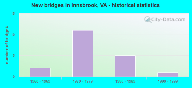
- New bridges - historical statistics
- 21960-1969
- 111970-1979
- 51980-1989
- 11990-1999


- Bridge Condition - Deck
- 25.0%Good
- 50.0%Satisfactory
- 25.0%Fair

- Bridge Condition - Superstructure
- 60.0%Satisfactory
- 40.0%Fair

- Bridge Condition - Substructure
- 20.0%Satisfactory
- 80.0%Fair

- Bridge Condition - Channel
- 14.3%Good
- 28.6%Satisfactory
- 28.6%Fair
- 28.6%Poor
Find on map >> Show street view
Structure Number: 938, Location: 0.0 TO HANOVER COUNTY LIN (Lat: 37.686300, Lng: -77.542864), Route carried "on" structure: US 33, Year Built: 1981, Status: Open, Structure Length: 4.69m (15.39ft), Average Daily Traffic: 8,483 (year 2020), Truck Traffic: 2%, Average Future Daily Traffic: 11,878 (year 2040), Design Load: HS 20+Mod, Features Intersected: CHICKAHOMINY RIVER, Facility Carried by Structure: WBL MOUNTAIN ROAD
Minimum Vertical Clearance: 30+ m (98+ ft), Kilometerpoint: 199.855, Lanes on structure: 2, Base Highway Network: Yes, Owner: State Highway Agency, Approaching Roadway Width: 12.0m (39.4ft), Material/Design: Steel, Design/Construction: Stringer/Multi-beam, Number Of Spans In Main Unit: 2, Length of Maximum Span: 22.7m (74.5ft), Curb-To-Curb Width: 11.7m (38.4ft), Out-to-Out Width: 12.7m (41.7ft)
Condition: Deck: Satisfactory, Superstructure: Fair, Substructure: Fair, Channel: Good, Operating Rating: 79.8 metric tons, Method Used To Determine Operating Rating: Load and Resistance Factor (LRFR), Inventory Rating: 61.7 metric tons, Method Used To Determine Inventory Rating: Load and Resistance Factor (LRFR), Structural Evaluation: Somewhat better than minimum adequacy, Deck Geometry: Better than present minimum criteria, Waterway Adequacy: Equal to present desirable criteria, Approach Roadway Alignment: Equal to present desirable criteria, Designated Inspection Frequency: Every 24 months, Inspection Date: May 2020, Deck Structure Type: Concrete Cast-file-Place, Wearing Surface/Protective System: Deck Protection: Epoxy Coated Reinforcing
Find on map >> Show street view
Structure Number: 9381, Location: 0.0 TO HANOVER COUNTY LIN (Lat: 37.686156, Lng: -77.542978), Route carried "on" structure: US 33, Year Built: 1971, Year Reconstructed: 2003, Status: Open, Structure Length: 3.72m (12.20ft), Average Daily Traffic: 8,483 (year 2020), Truck Traffic: 2%, Average Future Daily Traffic: 11,878 (year 2040), Design Load: HS 20+Mod, Features Intersected: CHICKAHOMINY RIVER, Facility Carried by Structure: EBL MOUNTAIN ROAD
Minimum Vertical Clearance: 30+ m (98+ ft), Kilometerpoint: 199.867, Lanes on structure: 3, Base Highway Network: Yes, Owner: State Highway Agency, Approaching Roadway Width: 14.3m (46.9ft), Material/Design: Steel, Design/Construction: Stringer/Multi-beam, Number Of Spans In Main Unit: 2, Length of Maximum Span: 17.9m (58.7ft), Curb-To-Curb Width: 14.4m (47.2ft), Out-to-Out Width: 15.5m (50.9ft)
Condition: Deck: Satisfactory, Superstructure: Fair, Substructure: Fair, Channel: Poor, Operating Rating: 52.6 metric tons, Method Used To Determine Operating Rating: Load and Resistance Factor (LRFR), Inventory Rating: 40.8 metric tons, Method Used To Determine Inventory Rating: Load and Resistance Factor (LRFR), Structural Evaluation: Somewhat better than minimum adequacy, Deck Geometry: Somewhat better than minimum adequacy, Waterway Adequacy: Equal to present desirable criteria, Approach Roadway Alignment: Equal to present desirable criteria, Length Of Structure Improvement: 4.11m (13.48ft), Designated Inspection Frequency: Every 24 months, Inspection Date: May 2020, Bridge Improvement Cost: $20,000, Roadway Improvement Cost: $35,000, Total Project Cost: $240,000 ( Estimate for 2014), Deck Structure Type: Concrete Cast-file-Place
Find on map >> Show street view
Structure Number: 9601, Location: .25NUCKOL RD &.83DEAD END (Lat: 37.673222, Lng: -77.578261), Route carried "on" structure: County highway , Year Built: 1979, Status: Open, Structure Length: 1.83m (6.00ft), Average Daily Traffic: 1,177 (year 2021), Truck Traffic: 50%, Average Future Daily Traffic: 1,394 (year 2038), Design Load: HS 20+Mod, Features Intersected: ALLEN BRANCH, Facility Carried by Structure: FORD'S COUNTY LA
Minimum Vertical Clearance: 30+ m (98+ ft), Kilometerpoint: 0.000, Lanes on structure: 2, Owner: County Highway Agency, Approaching Roadway Width: 7.3m (24.0ft), Skew: 4 degrees, Material/Design: Concrete, Design/Construction: Culvert, Number Of Spans In Main Unit: 4, Length of Maximum Span: 3.0m (9.8ft)
Condition: Channel: Satisfactory, Culverts: Satisfactory, Operating Rating: 54.4 metric tons, Method Used To Determine Operating Rating: Load Factor (LF), Inventory Rating: 32.7 metric tons, Method Used To Determine Inventory Rating: Load Factor (LF), Structural Evaluation: Equal to present minimum criteria, Waterway Adequacy: Equal to present desirable criteria, Approach Roadway Alignment: Equal to present desirable criteria, Designated Inspection Frequency: Every 24 months, Inspection Date: September 2021
Find on map >> Show street view
Structure Number: 9602, Location: .79NUCKOL RD & .29DEADEND (Lat: 37.675683, Lng: -77.567647), Route carried "on" structure: County highway , Year Built: 1979, Status: Open, Structure Length: 0.88m (2.89ft), Average Daily Traffic: 1,000 (year 2010), Truck Traffic: 5%, Average Future Daily Traffic: 2,500 (year 2031), Design Load: HS 20, Features Intersected: ROOTY BRANCH, Facility Carried by Structure: FORD'S COUNTY LA
Minimum Vertical Clearance: 30+ m (98+ ft), Kilometerpoint: 0.000, Lanes on structure: 2, Owner: County Highway Agency, Approaching Roadway Width: 6.1m (20.0ft), Skew: 4 degrees, Material/Design: Concrete, Design/Construction: Culvert, Number Of Spans In Main Unit: 2, Length of Maximum Span: 3.0m (9.8ft)
Condition: Channel: Good, Culverts: Satisfactory, Operating Rating: 54.4 metric tons, Method Used To Determine Operating Rating: Load Factor (LF), Inventory Rating: 32.7 metric tons, Method Used To Determine Inventory Rating: Load Factor (LF), Structural Evaluation: Equal to present minimum criteria, Waterway Adequacy: Equal to present desirable criteria, Approach Roadway Alignment: Equal to present desirable criteria, Designated Inspection Frequency: Every 24 months, Inspection Date: September 2021
Find on map >> Show street view
Structure Number: 9667, Location: .50 CHURCH RD .35 GASKINS (Lat: 37.633936, Lng: -77.580328), Route carried "on" structure: County highway , Year Built: 1972, Status: Open, Structure Length: 0.98m (3.22ft), Average Daily Traffic: 12,023 (year 2020), Truck Traffic: 1%, Average Future Daily Traffic: 13,225 (year 2040), Design Load: HS 20, Features Intersected: DEEP RUN CREEK, Facility Carried by Structure: THREE CHOPT ROAD
Minimum Vertical Clearance: 30+ m (98+ ft), Kilometerpoint: 2.944, Lanes on structure: 2, Owner: County Highway Agency, Approaching Roadway Width: 7.6m (24.9ft), Material/Design: Concrete, Design/Construction: Culvert, Number Of Spans In Main Unit: 3, Length of Maximum Span: 3.0m (9.8ft)
Condition: Channel: Satisfactory, Culverts: Satisfactory, Operating Rating: 42.6 metric tons, Method Used To Determine Operating Rating: Load and Resistance Factor (LRFR), Inventory Rating: 25.6 metric tons, Method Used To Determine Inventory Rating: Load and Resistance Factor (LRFR), Structural Evaluation: Equal to present minimum criteria, Waterway Adequacy: Equal to present minimum criteria, Approach Roadway Alignment: Equal to present minimum criteria, Designated Inspection Frequency: Every 24 months, Inspection Date: June 2020
Find on map >> Show street view
Structure Number: 9684, Location: .2frSadler & .43 to F-318 (Lat: 37.671164, Lng: -77.581525), Route carried "on" structure: County highway 7706, Year Built: 1980, Status: Open, Structure Length: 15.10m (49.54ft), Average Daily Traffic: 15,538 (year 2020), Average Future Daily Traffic: 21,755 (year 2040), Design Load: HS 20+Mod, Features Intersected: ROUTE 0295, Facility Carried by Structure: NBL NUCKOLS ROAD
Minimum Vertical Clearance: 30+ m (98+ ft), Kilometerpoint: 5.519, Lanes on structure: 3, Lanes under structure: 8, Owner: State Highway Agency, Approaching Roadway Width: 16.2m (53.1ft), Skew: 1 degrees, Material/Design: Steel continuous, Design/Construction: Stringer/Multi-beam, Number Of Spans In Main Unit: 3, Number Of Approach Spans: 2, Length of Maximum Span: 49.7m (163.1ft), Curb-To-Curb Width: 15.4m (50.5ft), Out-to-Out Width: 16.4m (53.8ft)
Condition: Deck: Fair, Superstructure: Satisfactory, Substructure: Fair, Operating Rating: 70.8 metric tons, Method Used To Determine Operating Rating: Load and Resistance Factor (LRFR), Inventory Rating: 54.4 metric tons, Method Used To Determine Inventory Rating: Load and Resistance Factor (LRFR), Structural Evaluation: Somewhat better than minimum adequacy, Deck Geometry: Equal to present minimum criteria, Underclear: Better than present minimum criteria, Approach Roadway Alignment: Equal to present desirable criteria, Designated Inspection Frequency: Every 24 months, Inspection Date: July 2021, Deck Structure Type: Concrete Cast-file-Place, Wearing Surface/Protective System: Deck Protection: Epoxy Coated Reinforcing
Find on map >> Show street view
Structure Number: 9794, Location: .79 fr 295/2.81 to Rte 73 (Lat: 37.648606, Lng: -77.594039), Route carried "on" structure: Interstate 64, Year Built: 1967, Status: Open, Structure Length: 9.02m (29.59ft), Average Daily Traffic: 28,199 (year 2020), Truck Traffic: 3%, Average Future Daily Traffic: 39,479 (year 2040), Design Load: HS 20+Mod, Features Intersected: RTE 250
Minimum Vertical Clearance: 30+ m (98+ ft), Kilometerpoint: 287.786, Lanes on structure: 4, Lanes under structure: 7, Base Highway Network: Yes, Owner: State Highway Agency, Approaching Roadway Width: 21.9m (71.9ft), Skew: 4 degrees, Material/Design: Steel, Design/Construction: Stringer/Multi-beam, Number Of Spans In Main Unit: 4, Length of Maximum Span: 25.0m (82.0ft), Curb or Sidewalk Widths: Left: 0.5m (1.6ft), Right: 0.5m (1.6ft), Curb-To-Curb Width: 21.9m (71.9ft), Out-to-Out Width: 23.0m (75.5ft)
Condition: Deck: Good, Superstructure: Satisfactory, Substructure: Fair, Operating Rating: 75.4 metric tons, Method Used To Determine Operating Rating: Load and Resistance Factor (LRFR), Inventory Rating: 58.2 metric tons, Method Used To Determine Inventory Rating: Load and Resistance Factor (LRFR), Structural Evaluation: Somewhat better than minimum adequacy, Deck Geometry: Better than present minimum criteria, Underclear: Equal to present minimum criteria, Approach Roadway Alignment: Equal to present desirable criteria, Length Of Structure Improvement: 9.02m (29.59ft), Designated Inspection Frequency: Every 24 months, Inspection Date: March 2021, Bridge Improvement Cost: $775,000, Roadway Improvement Cost: $1,000, Total Project Cost: $1,009,000, Deck Structure Type: Concrete Cast-file-Place, Wearing Surface/Protective System: Deck Protection: Epoxy Coated Reinforcing
Find on map >> Show street view
Structure Number: 9827, Location: 0.23FrI-64WBL&0.23ToGask (Lat: 37.634025, Lng: -77.571150), Route carried "on" structure: Ramp Interstate 64, Year Built: 1988, Status: Open, Structure Length: 0.79m (2.59ft), Average Daily Traffic: 7,193 (year 2020), Average Future Daily Traffic: 9,260 (year 2040), Design Load: HS 20+Mod, Features Intersected: UNKNOWN TRIB
Minimum Vertical Clearance: 30+ m (98+ ft), Kilometerpoint: 0.370, Lanes on structure: 1, Base Highway Network: Yes, Owner: State Highway Agency, Approaching Roadway Width: 9.8m (32.2ft), Skew: 3 degrees, Material/Design: Concrete, Design/Construction: Culvert, Number Of Spans In Main Unit: 2, Length of Maximum Span: 3.9m (12.8ft)
Condition: Channel: Satisfactory, Culverts: Satisfactory, Operating Rating: 70.2 metric tons, Method Used To Determine Operating Rating: Load and Resistance Factor (LRFR), Inventory Rating: 54.2 metric tons, Method Used To Determine Inventory Rating: Load and Resistance Factor (LRFR), Structural Evaluation: Equal to present minimum criteria, Waterway Adequacy: Better than present minimum criteria, Approach Roadway Alignment: Equal to present desirable criteria, Designated Inspection Frequency: Every 24 months, Inspection Date: November 2020
Find on map >> Show street view
Structure Number: 9934, Location: .80 TO 64 & .90 TO NUCKOL (Lat: 37.664275, Lng: -77.595222), Route carried "on" structure: Interstate 295, Year Built: 1979, Status: Open, Structure Length: 0.79m (2.59ft), Average Daily Traffic: 25,082 (year 2020), Truck Traffic: 6%, Average Future Daily Traffic: 35,115 (year 2040), Design Load: HS 20+Mod, Features Intersected: ALLENS BRANCH
Minimum Vertical Clearance: 30+ m (98+ ft), Kilometerpoint: 1.352, Lanes on structure: 3, Base Highway Network: Yes, Owner: State Highway Agency, Approaching Roadway Width: 18.3m (60.0ft), Skew: 3 degrees, Material/Design: Concrete, Design/Construction: Culvert, Number Of Spans In Main Unit: 3, Length of Maximum Span: 2.4m (7.9ft)
Condition: Channel: Fair, Culverts: Satisfactory, Operating Rating: 54.4 metric tons, Method Used To Determine Operating Rating: Field evaluation and documented engineering judgment, Inventory Rating: 32.7 metric tons, Method Used To Determine Inventory Rating: Field evaluation and documented engineering judgment, Structural Evaluation: Equal to present minimum criteria, Waterway Adequacy: Better than present minimum criteria, Approach Roadway Alignment: Equal to present desirable criteria, Designated Inspection Frequency: Every 24 months, Inspection Date: October 2021
Find on map >> Show street view
Structure Number: 9937, Location: .20 TO 295 & .25 TO NUCKO (Lat: 37.672864, Lng: -77.578800), Route carried "on" structure: Ramp Interstate 295, Year Built: 1979, Status: Open, Structure Length: 1.62m (5.31ft), Average Daily Traffic: 5,477 (year 2020), Truck Traffic: 4%, Average Future Daily Traffic: 7,668 (year 2040), Design Load: HS 20+Mod, Features Intersected: ALLENS BRANCH
Minimum Vertical Clearance: 30+ m (98+ ft), Kilometerpoint: 0.000, Lanes on structure: 1, Base Highway Network: Yes, Owner: State Highway Agency, Approaching Roadway Width: 9.8m (32.2ft), Skew: 3 degrees, Material/Design: Concrete, Design/Construction: Culvert, Number Of Spans In Main Unit: 4, Length of Maximum Span: 4.0m (13.1ft)
Condition: Channel: Fair, Culverts: Satisfactory, Operating Rating: 54.4 metric tons, Method Used To Determine Operating Rating: Field evaluation and documented engineering judgment, Inventory Rating: 32.7 metric tons, Method Used To Determine Inventory Rating: Field evaluation and documented engineering judgment, Structural Evaluation: Equal to present minimum criteria, Waterway Adequacy: Equal to present minimum criteria, Approach Roadway Alignment: Equal to present desirable criteria, Designated Inspection Frequency: Every 24 months, Inspection Date: September 2021
Find on map >> Show street view
Structure Number: 9938, Location: 0.7 NUCKOLS &1.58 TO 33 (Lat: 37.674278, Lng: -77.568422), Route carried "on" structure: Interstate 295, Year Built: 1979, Status: Open, Structure Length: 0.88m (2.89ft), Average Daily Traffic: 25,092 (year 2020), Truck Traffic: 6%, Average Future Daily Traffic: 35,129 (year 2040), Design Load: HS 20+Mod, Features Intersected: ROOTY BRANCH
Minimum Vertical Clearance: 30+ m (98+ ft), Kilometerpoint: 4.006, Lanes on structure: 3, Base Highway Network: Yes, Owner: State Highway Agency, Approaching Roadway Width: 18.3m (60.0ft), Skew: 4 degrees, Material/Design: Concrete, Design/Construction: Culvert, Number Of Spans In Main Unit: 2, Length of Maximum Span: 4.3m (14.1ft)
Condition: Channel: Poor, Culverts: Satisfactory, Operating Rating: 76.9 metric tons, Method Used To Determine Operating Rating: Load and Resistance Factor (LRFR), Inventory Rating: 59.3 metric tons, Method Used To Determine Inventory Rating: Load and Resistance Factor (LRFR), Structural Evaluation: Equal to present minimum criteria, Waterway Adequacy: Better than present minimum criteria, Approach Roadway Alignment: Equal to present desirable criteria, Designated Inspection Frequency: Every 24 months, Inspection Date: April 2021
Find on map >> Show street view
Structure Number: 9939, Location: 0.8 NUCKOLS & 1.6 TO 33 (Lat: 37.675231, Lng: -77.567853), Route carried "on" structure: Interstate 295, Year Built: 1979, Status: Open, Structure Length: 0.88m (2.89ft), Average Daily Traffic: 26,579 (year 2020), Truck Traffic: 6%, Average Future Daily Traffic: 37,211 (year 2040), Design Load: HS 20+Mod, Features Intersected: ROOTY BRANCH
Minimum Vertical Clearance: 30+ m (98+ ft), Kilometerpoint: 4.039, Lanes on structure: 3, Base Highway Network: Yes, Owner: State Highway Agency, Approaching Roadway Width: 18.3m (60.0ft), Skew: 4 degrees, Material/Design: Concrete, Design/Construction: Culvert, Number Of Spans In Main Unit: 2, Length of Maximum Span: 3.0m (9.8ft)
Condition: Channel: Poor, Culverts: Satisfactory, Operating Rating: 54.4 metric tons, Method Used To Determine Operating Rating: Field evaluation and documented engineering judgment, Inventory Rating: 32.7 metric tons, Method Used To Determine Inventory Rating: Field evaluation and documented engineering judgment, Structural Evaluation: Equal to present minimum criteria, Waterway Adequacy: Better than present minimum criteria, Approach Roadway Alignment: Equal to present desirable criteria, Designated Inspection Frequency: Every 24 months, Inspection Date: April 2021
Find on map >> Show street view
Structure Number: 994, Location: 1.9 NUCKLS RD & .38 TO 33 (Lat: 37.679203, Lng: -77.547044), Route carried "on" structure: Interstate 295, Year Built: 1979, Status: Open, Structure Length: 1.07m (3.51ft), Average Daily Traffic: 25,092 (year 2020), Truck Traffic: 6%, Average Future Daily Traffic: 35,129 (year 2040), Design Load: HS 20+Mod, Features Intersected: MEREDITH BRANCH
Minimum Vertical Clearance: 30+ m (98+ ft), Kilometerpoint: 5.937, Lanes on structure: 3, Base Highway Network: Yes, Owner: State Highway Agency, Approaching Roadway Width: 21.9m (71.9ft), Skew: 3 degrees, Material/Design: Concrete, Design/Construction: Culvert, Number Of Spans In Main Unit: 4, Length of Maximum Span: 2.4m (7.9ft)
Condition: Channel: Fair, Culverts: Satisfactory, Operating Rating: 54.4 metric tons, Method Used To Determine Operating Rating: Field evaluation and documented engineering judgment, Inventory Rating: 32.7 metric tons, Method Used To Determine Inventory Rating: Field evaluation and documented engineering judgment, Structural Evaluation: Equal to present minimum criteria, Waterway Adequacy: Better than present minimum criteria, Approach Roadway Alignment: Equal to present desirable criteria, Designated Inspection Frequency: Every 24 months, Inspection Date: April 2021
Find on map >> Show street view
Structure Number: 9941, Location: 1.39FR Nuckols& .36 TO 33 (Lat: 37.679975, Lng: -77.546775), Route carried "on" structure: Interstate 295, Year Built: 1979, Status: Open, Structure Length: 0.98m (3.22ft), Average Daily Traffic: 26,579 (year 2020), Truck Traffic: 6%, Average Future Daily Traffic: 37,211 (year 2040), Design Load: HS 20+Mod, Features Intersected: MEREDITH BRANCH
Minimum Vertical Clearance: 30+ m (98+ ft), Kilometerpoint: 5.969, Lanes on structure: 3, Base Highway Network: Yes, Owner: State Highway Agency, Approaching Roadway Width: 21.9m (71.9ft), Skew: 1 degrees, Material/Design: Concrete, Design/Construction: Culvert, Number Of Spans In Main Unit: 4, Length of Maximum Span: 2.1m (6.9ft)
Condition: Channel: Fair, Culverts: Satisfactory, Operating Rating: 54.4 metric tons, Method Used To Determine Operating Rating: Field evaluation and documented engineering judgment, Inventory Rating: 32.7 metric tons, Method Used To Determine Inventory Rating: Field evaluation and documented engineering judgment, Structural Evaluation: Equal to present minimum criteria, Waterway Adequacy: Better than present minimum criteria, Approach Roadway Alignment: Equal to present desirable criteria, Designated Inspection Frequency: Every 24 months, Inspection Date: May 2021
Find on map >> Show street view
Structure Number: 9944, Location: 0.25 NUCKOLS & 0.05 I-295 (Lat: 37.672253, Lng: -77.579675), Route carried "on" structure: Ramp Interstate 295, Year Built: 1979, Status: Open, Structure Length: 1.46m (4.79ft), Average Daily Traffic: 2,833 (year 2020), Average Future Daily Traffic: 3,966 (year 2040), Design Load: HS 20+Mod, Features Intersected: ALLENS BRANCH
Minimum Vertical Clearance: 30+ m (98+ ft), Kilometerpoint: 0.000, Lanes on structure: 1, Base Highway Network: Yes, Owner: State Highway Agency, Approaching Roadway Width: 9.8m (32.2ft), Skew: 3 degrees, Material/Design: Concrete, Design/Construction: Culvert, Number Of Spans In Main Unit: 4, Length of Maximum Span: 3.7m (12.1ft)
Condition: Channel: Poor, Culverts: Satisfactory, Structural Evaluation: Equal to present minimum criteria, Waterway Adequacy: Equal to present desirable criteria, Approach Roadway Alignment: Equal to present desirable criteria, Designated Inspection Frequency: Every 24 months, Inspection Date: October 2021
Find on map >> Show street view
Structure Number: 315, Location: 0.08 West of Gaskins Rd (Lat: 37.640861, Lng: -77.573972), Route carried "on" structure: County highway , Year Built: 1990, Status: Open, Structure Length: 1.28m (4.20ft), Average Daily Traffic: 100 (year 2021), Average Future Daily Traffic: 118 (year 2038), Design Load: HS 20+Mod, Features Intersected: Deep Run, Facility Carried by Structure: Mayland Road
Minimum Vertical Clearance: 30+ m (98+ ft), Kilometerpoint: 0.000, Lanes on structure: 2, Owner: County Highway Agency, Approaching Roadway Width: 15.5m (50.9ft), Material/Design: Concrete, Design/Construction: Arch - Deck, Number Of Spans In Main Unit: 1, Length of Maximum Span: 11.6m (38.1ft), Curb-To-Curb Width: 15.5m (50.9ft), Out-to-Out Width: 15.5m (50.9ft)
Condition: Superstructure: Satisfactory, Substructure: Satisfactory, Channel: Satisfactory, Operating Rating: 54.5 metric tons, Method Used To Determine Operating Rating: Load Factor (LF), Inventory Rating: 32.7 metric tons, Method Used To Determine Inventory Rating: Load Factor (LF), Structural Evaluation: Equal to present minimum criteria, Deck Geometry: Superior to present desirable criteria, Waterway Adequacy: Equal to present minimum criteria, Approach Roadway Alignment: Better than present minimum criteria, Designated Inspection Frequency: Every 24 months, Inspection Date: Febuary 2021
Find on map >> Show street view
Structure Number: 9684, Location: .2frSadler & .43 to F-318 (Lat: 37.671164, Lng: -77.581525), Route carried "under" structure: Interstate 295, Year Built: 1980, Structure Length: 0. m, Average Daily Traffic: 50,000 (year 2020), Truck Traffic: 7%, Features Intersected: ROUTE 0295, Facility Carried by Structure: NBL NUCKOLS ROAD
Minimum Vertical Clearance: 5.64m (18.50ft), Kilometerpoint: 2.430, Lanes on structure: 3, Lanes under structure: 8, Material/Design: Steel continuous, Design/Construction: Stringer/Multi-beam, Length of Maximum Span: 49.7m (163.1ft)
Find on map >> Show street view
Structure Number: 9702, Location: 0.40 THR CH RD & 0.60 250 (Lat: 37.634450, Lng: -77.574750), Route carried "under" structure: Interstate 64, Year Built: 1988, Structure Length: 0. m, Average Daily Traffic: 87,000 (year 2017), Truck Traffic: 1%, Features Intersected: ROUTE 0064, Facility Carried by Structure: GASKINS ROAD
Minimum Vertical Clearance: 5.94m (19.49ft), Kilometerpoint: 290.038, Lanes on structure: 6, Lanes under structure: 8, Material/Design: Steel continuous, Design/Construction: Stringer/Multi-beam, Length of Maximum Span: 34.4m (112.9ft)
Find on map >> Show street view
Structure Number: 9794, Location: .79 fr 295/2.81 to Rte 73 (Lat: 37.648606, Lng: -77.594039), Route carried "under" structure: US 250, Year Built: 1967, Structure Length: 0. m, Average Daily Traffic: 43,668 (year 2008), Truck Traffic: 1%, Features Intersected: RTE 250, Facility Carried by Structure: WBL I-64
Minimum Vertical Clearance: 5.46m (17.91ft), Kilometerpoint: 248.076, Lanes on structure: 4, Lanes under structure: 7, Material/Design: Steel, Design/Construction: Stringer/Multi-beam, Length of Maximum Span: 25.0m (82.0ft)