Bridge Statistics for Inglewood, California (CA)
Condition, Traffic, Stress, Structural Evaluation, Project Costs
- National Bridge Inventory (NBI) Statistics
- 55Number of bridges
- 410ft / 125mTotal length
- 5,460,932Total average daily traffic
- 223,381Total average daily truck traffic
- National Bridge Inventory (NBI) Registered Bridges for Inglewood
- No street view available for this location
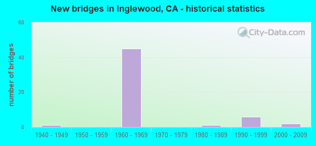
- New bridges - historical statistics
- 11940-1949
- 451960-1969
- 11980-1989
- 61990-1999
- 22000-2009


- Bridge Condition - Deck
- 94.1%Good
- 5.9%Satisfactory

- Bridge Condition - Superstructure
- 88.2%Good
- 5.9%Fair
- 5.9%Poor

- Bridge Condition - Channel
- 50.0%Excellent
- 50.0%Very good
Find on map >> Show street view
Structure Number: 53 0143, Location: 07-LA-027-2.02 (Lat: 34.064089, Lng: -118.586956), Route carried "on" structure: State highway 27, Year Built: 1941, Year Reconstructed: 1989, Status: Open, Structure Length: 3.54m (11.61ft), Average Daily Traffic: 15,950 (year 2014), Truck Traffic: 2%, Average Future Daily Traffic: 16,398 (year 2039), Design Load: HS 20, Features Intersected: TOPANGA CREEK
Minimum Vertical Clearance: 30+ m (98+ ft), Kilometerpoint: 2.020, Lanes on structure: 2, Base Highway Network: Yes (, Subroute: 1), Owner: State Highway Agency, Approaching Roadway Width: 12.2m (40.0ft), Skew: 4 degrees, Material/Design: Concrete, Design/Construction: Tee Beam, Number Of Spans In Main Unit: 1, Length of Maximum Span: 33.4m (109.6ft), Curb-To-Curb Width: 12.2m (40.0ft), Out-to-Out Width: 13.3m (43.6ft)
Condition: Deck: Good, Superstructure: Good, Substructure: Good, Channel: Very good, Operating Rating: 99.8 metric tons, Method Used To Determine Operating Rating: Load Factor (LF), Inventory Rating: 62.5 metric tons, Method Used To Determine Inventory Rating: Load Factor (LF), Structural Evaluation: Better than present minimum criteria, Deck Geometry: Somewhat better than minimum adequacy, Waterway Adequacy: Equal to present desirable criteria, Approach Roadway Alignment: Better than present minimum criteria, Designated Inspection Frequency: Every 24 months, Inspection Date: Febuary 2022, Deck Structure Type: Concrete Cast-file-Place
Find on map >> Show street view
Structure Number: 53 124, Location: 07-LA-405-R20.73-ESEG (Lat: 33.923694, Lng: -118.368364), Route carried "on" structure: Interstate 405, Year Built: 1963, Year Reconstructed: 1989, Status: Open, Structure Length: 4.48m (14.70ft), Average Daily Traffic: 260,800 (year 2012), Truck Traffic: 5%, Average Future Daily Traffic: 304,690 (year 2037), Design Load: HS 20, Features Intersected: 120TH STREET
Minimum Vertical Clearance: 30+ m (98+ ft), Kilometerpoint: 20.730, Lanes on structure: 12, Lanes under structure: 4, Base Highway Network: Yes (Inventory Route: 4, Subroute: 1), Owner: State Highway Agency, Approaching Roadway Width: 50.9m (167.0ft), Skew: 39 degrees, Material/Design: Concrete continuous, Design/Construction: Box Beam or Girders - Multiple, Number Of Spans In Main Unit: 3, Length of Maximum Span: 25.9m (85.0ft), Curb-To-Curb Width: 50.6m (166.0ft), Out-to-Out Width: 52.3m (171.6ft)
Condition: Deck: Good, Superstructure: Good, Substructure: Good, Operating Rating: 53.5 metric tons, Method Used To Determine Operating Rating: Load Factor (LF), Inventory Rating: 32.6 metric tons, Method Used To Determine Inventory Rating: Load Factor (LF), Structural Evaluation: Better than present minimum criteria, Deck Geometry: Better than present minimum criteria, Underclear: Somewhat better than minimum adequacy, Approach Roadway Alignment: Equal to present desirable criteria, Designated Inspection Frequency: Every 24 months, Inspection Date: December 2020, Deck Structure Type: Concrete Cast-file-Place
Find on map >> Show street view
Structure Number: 53 1243, Location: 07-LA-405-22.22-ING (Lat: 33.945139, Lng: -118.367900), Route carried "on" structure: Interstate 405, Year Built: 1963, Status: Open, Structure Length: 5.94m (19.49ft), Average Daily Traffic: 293,500 (year 2019), Truck Traffic: 4%, Average Future Daily Traffic: 385,027 (year 2038), Design Load: HS 20, Features Intersected: CENTURY BLVD
Minimum Vertical Clearance: 30+ m (98+ ft), Kilometerpoint: 22.220, Lanes on structure: 12, Lanes under structure: 7, Base Highway Network: Yes (Inventory Route: 4, Subroute: 1), Owner: State Highway Agency, Approaching Roadway Width: 21.6m (70.9ft), Skew: 20 degrees, Material/Design: Concrete continuous, Design/Construction: Box Beam or Girders - Multiple, Number Of Spans In Main Unit: 3, Length of Maximum Span: 31.4m (103.0ft), Curb or Sidewalk Widths: Left: 0.6m (2.0ft), Right: 0.6m (2.0ft), Curb-To-Curb Width: 91.8m (301.2ft), Out-to-Out Width: 93.5m (306.8ft)
Condition: Deck: Good, Superstructure: Good, Substructure: Good, Operating Rating: 29.8 metric tons, Method Used To Determine Operating Rating: Load and Resistance Factor Rating (LRFR) rating reported by rating factor(RF) method using HL-93 loadings, Inventory Rating: 23.0 metric tons, Method Used To Determine Inventory Rating: Load and Resistance Factor Rating (LRFR) rating reported by rating factor(RF) method using HL-93 loadings, Structural Evaluation: Somewhat better than minimum adequacy, Deck Geometry: Superior to present desirable criteria, Underclear: High priority of corrective action, Approach Roadway Alignment: Equal to present desirable criteria, Designated Inspection Frequency: Every 24 months, Inspection Date: January 2021, Deck Structure Type: Concrete Cast-file-Place
Find on map >> Show street view
Structure Number: 53 1244, Location: 07-LA-405-22.74-ING (Lat: 33.952589, Lng: -118.369956), Route carried "on" structure: City street L666, Year Built: 1963, Status: Open, Structure Length: 12.56m (41.21ft), Average Daily Traffic: 18,537 (year 2019), Truck Traffic: 2%, Average Future Daily Traffic: 23,967 (year 2038), Design Load: HS 20, Features Intersected: ROUTE 405, Facility Carried by Structure: ARBOR VITAE STREET
Minimum Vertical Clearance: 30+ m (98+ ft), Kilometerpoint: 0.000, Lanes on structure: 5, Lanes under structure: 16, Owner: State Highway Agency, Approaching Roadway Width: 19.5m (64.0ft), Material/Design: Prestressed concrete, Design/Construction: Stringer/Multi-beam, Number Of Spans In Main Unit: 1, Number Of Approach Spans: 5, Length of Maximum Span: 31.1m (102.0ft), Curb or Sidewalk Widths: Left: 1.5m (4.9ft), Right: 1.5m (4.9ft), Curb-To-Curb Width: 19.5m (64.0ft), Out-to-Out Width: 23.8m (78.1ft)
Condition: Deck: Good, Superstructure: Good, Substructure: Good, Operating Rating: 44.1 metric tons, Method Used To Determine Operating Rating: Load and Resistance Factor Rating (LRFR) rating reported by rating factor(RF) method using HL-93 loadings, Inventory Rating: 28.2 metric tons, Method Used To Determine Inventory Rating: Load and Resistance Factor Rating (LRFR) rating reported by rating factor(RF) method using HL-93 loadings, Structural Evaluation: Better than present minimum criteria, Deck Geometry: Meets minimum limits, Underclear: High priority of corrective action, Approach Roadway Alignment: Equal to present desirable criteria, Designated Inspection Frequency: Every 24 months, Inspection Date: January 2021, Deck Structure Type: Concrete Cast-file-Place
Find on map >> Show street view
Structure Number: 53 1245, Location: 07-LA-405-23.00-ING (Lat: 33.956267, Lng: -118.369947), Route carried "on" structure: City street Q704, Year Built: 1963, Status: Open, Structure Length: 10.06m (33.01ft), Average Daily Traffic: 10,000 (year 2012), Truck Traffic: 2%, Average Future Daily Traffic: 14,584 (year 2043), Design Load: HS 20, Features Intersected: ROUTE 405, Facility Carried by Structure: HILLCREST BLVD
Minimum Vertical Clearance: 30+ m (98+ ft), Kilometerpoint: 0.000, Lanes on structure: 2, Lanes under structure: 14, Owner: State Highway Agency, Approaching Roadway Width: 11.0m (36.1ft), Skew: 1 degrees, Material/Design: Concrete continuous, Design/Construction: Box Beam or Girders - Multiple, Number Of Spans In Main Unit: 6, Length of Maximum Span: 25.9m (85.0ft), Curb or Sidewalk Widths: Left: 1.5m (4.9ft), Right: 1.5m (4.9ft), Curb-To-Curb Width: 11.0m (36.1ft), Out-to-Out Width: 15.2m (49.9ft)
Condition: Deck: Good, Superstructure: Good, Substructure: Good, Operating Rating: 38.2 metric tons, Method Used To Determine Operating Rating: Load and Resistance Factor Rating (LRFR) rating reported by rating factor(RF) method using HL-93 loadings, Inventory Rating: 29.5 metric tons, Method Used To Determine Inventory Rating: Load and Resistance Factor Rating (LRFR) rating reported by rating factor(RF) method using HL-93 loadings, Structural Evaluation: Better than present minimum criteria, Deck Geometry: Meets minimum limits, Underclear: Meets minimum limits, Approach Roadway Alignment: Superior to present desirable criteria, Designated Inspection Frequency: Every 24 months, Inspection Date: January 2021, Deck Structure Type: Concrete Cast-file-Place
Find on map >> Show street view
Structure Number: 53 1246, Location: 07-LA-405-23.36-ING (Lat: 33.961469, Lng: -118.369703), Route carried "on" structure: City street , Year Built: 1961, Status: Open, Structure Length: 5.97m (19.59ft), Average Daily Traffic: 150,000 (year 2014), Truck Traffic: 5%, Average Future Daily Traffic: 165,667 (year 2043), Design Load: HS 20, Features Intersected: ROUTE 405 & MNCHSTR-N405, Facility Carried by Structure: MANCHESTER BLVD
Minimum Vertical Clearance: 30+ m (98+ ft), Kilometerpoint: 0.000, Lanes on structure: 7, Lanes under structure: 11, Base Highway Network: Yes, Owner: State Highway Agency, Approaching Roadway Width: 24.4m (80.1ft), Skew: 20 degrees, Material/Design: Concrete continuous, Design/Construction: Box Beam or Girders - Multiple, Number Of Spans In Main Unit: 3, Length of Maximum Span: 25.0m (82.0ft), Curb or Sidewalk Widths: Left: 1.8m (5.9ft), Right: 1.8m (5.9ft), Curb-To-Curb Width: 24.4m (80.1ft), Out-to-Out Width: 29.3m (96.1ft)
Condition: Deck: Good, Superstructure: Fair, Substructure: Good, Operating Rating: 35.3 metric tons, Method Used To Determine Operating Rating: Load and Resistance Factor Rating (LRFR) rating reported by rating factor(RF) method using HL-93 loadings, Inventory Rating: 27.2 metric tons, Method Used To Determine Inventory Rating: Load and Resistance Factor Rating (LRFR) rating reported by rating factor(RF) method using HL-93 loadings, Structural Evaluation: Somewhat better than minimum adequacy, Deck Geometry: High priority of replacement, Underclear: High priority of corrective action, Approach Roadway Alignment: Equal to present desirable criteria, Designated Inspection Frequency: Every 24 months, Inspection Date: January 2021, Deck Structure Type: Concrete Cast-file-Place, Wearing Surface/Protective System: Wearing Surface: Other
Find on map >> Show street view
Structure Number: 53 1248, Location: 07-LA-405-23.50-ING (Lat: 33.963436, Lng: -118.370211), Route carried "on" structure: City street L120, Year Built: 1961, Status: Open, Structure Length: 8.17m (26.80ft), Average Daily Traffic: 9,500 (year 2019), Truck Traffic: 2%, Average Future Daily Traffic: 13,856 (year 2038), Design Load: HS 20, Features Intersected: I-405 & NB RAMPS, Facility Carried by Structure: W FLORENCE AVENUE
Minimum Vertical Clearance: 30+ m (98+ ft), Kilometerpoint: 0.000, Lanes on structure: 5, Lanes under structure: 13, Owner: State Highway Agency, Approaching Roadway Width: 17.1m (56.1ft), Skew: 1 degrees, Material/Design: Concrete continuous, Design/Construction: Box Beam or Girders - Multiple, Number Of Spans In Main Unit: 4, Length of Maximum Span: 26.2m (86.0ft), Curb or Sidewalk Widths: Left: 0.9m (3.0ft), Right: 1.8m (5.9ft), Curb-To-Curb Width: 17.1m (56.1ft), Out-to-Out Width: 20.4m (66.9ft)
Condition: Deck: Good, Superstructure: Good, Substructure: Good, Operating Rating: 37.3 metric tons, Method Used To Determine Operating Rating: Load and Resistance Factor Rating (LRFR) rating reported by rating factor(RF) method using HL-93 loadings, Inventory Rating: 28.8 metric tons, Method Used To Determine Inventory Rating: Load and Resistance Factor Rating (LRFR) rating reported by rating factor(RF) method using HL-93 loadings, Structural Evaluation: Better than present minimum criteria, Deck Geometry: High priority of replacement, Underclear: High priority of corrective action, Approach Roadway Alignment: Superior to present desirable criteria, Designated Inspection Frequency: Every 24 months, Inspection Date: January 2021, Deck Structure Type: Concrete Cast-file-Place
Find on map >> Show street view
Structure Number: 53 1249, Location: 07-LA-405-23.64-ING (Lat: 33.964689, Lng: -118.370839), Route carried "on" structure: City street L130, Year Built: 1961, Status: Open, Structure Length: 16.15m (52.99ft), Average Daily Traffic: 45,291 (year 2014), Truck Traffic: 2%, Average Future Daily Traffic: 69,940 (year 2043), Design Load: HS 20, Features Intersected: INTERSTATE 405, Facility Carried by Structure: LA CIENEGA BLVD NB
Minimum Vertical Clearance: 30+ m (98+ ft), Kilometerpoint: 0.000, Lanes on structure: 2, Lanes under structure: 10, Owner: State Highway Agency, Approaching Roadway Width: 8.5m (27.9ft), Skew: 6 degrees, Material/Design: Concrete continuous, Design/Construction: Box Beam or Girders - Multiple, Number Of Spans In Main Unit: 5, Length of Maximum Span: 39.3m (128.9ft), Curb or Sidewalk Widths: Left: 0.6m (2.0ft), Right: 0.6m (2.0ft), Curb-To-Curb Width: 8.5m (27.9ft), Out-to-Out Width: 10.4m (34.1ft)
Condition: Deck: Good, Superstructure: Good, Substructure: Good, Operating Rating: 36.3 metric tons, Method Used To Determine Operating Rating: Load and Resistance Factor Rating (LRFR) rating reported by rating factor(RF) method using HL-93 loadings, Inventory Rating: 26.6 metric tons, Method Used To Determine Inventory Rating: Load and Resistance Factor Rating (LRFR) rating reported by rating factor(RF) method using HL-93 loadings, Structural Evaluation: Equal to present minimum criteria, Deck Geometry: Meets minimum limits, Underclear: High priority of corrective action, Approach Roadway Alignment: Superior to present desirable criteria, Designated Inspection Frequency: Every 24 months, Inspection Date: January 2021, Deck Structure Type: Concrete Cast-file-Place
Find on map >> Show street view
Structure Number: 53 1253, Location: 07-LA-405-25.27-ING (Lat: 33.979506, Lng: -118.392258), Route carried "on" structure: Interstate 405, Year Built: 1963, Year Reconstructed: 1987, Status: Open, Structure Length: 16.25m (53.31ft), Average Daily Traffic: 283,000 (year 2014), Truck Traffic: 4%, Average Future Daily Traffic: 422,349 (year 2043), Design Load: HS 20+Mod, Features Intersected: CENTINELA AVENUE
Minimum Vertical Clearance: 30+ m (98+ ft), Kilometerpoint: 25.270, Lanes on structure: 10, Lanes under structure: 6, Base Highway Network: Yes (Inventory Route: 4, Subroute: 1), Owner: State Highway Agency, Approaching Roadway Width: 48.9m (160.4ft), Skew: 39 degrees, Material/Design: Concrete continuous, Design/Construction: Tee Beam, Number Of Spans In Main Unit: 5, Length of Maximum Span: 34.4m (112.9ft), Curb-To-Curb Width: 48.9m (160.4ft), Out-to-Out Width: 52.4m (171.9ft)
Condition: Deck: Satisfactory, Superstructure: Good, Substructure: Good, Operating Rating: 61.6 metric tons, Method Used To Determine Operating Rating: Load Factor (LF), Inventory Rating: 37.2 metric tons, Method Used To Determine Inventory Rating: Load Factor (LF), Structural Evaluation: Better than present minimum criteria, Deck Geometry: Superior to present desirable criteria, Underclear: High priority of corrective action, Approach Roadway Alignment: Better than present minimum criteria, Designated Inspection Frequency: Every 24 months, Inspection Date: Febuary 2021, Deck Structure Type: Concrete Cast-file-Place
Find on map >> Show street view
Structure Number: 53 1466, Location: 07-LA-405-23.36-ING (Lat: 33.961483, Lng: -118.368819), Route carried "on" structure: City street 6105, Year Built: 1961, Status: Open, Structure Length: 1.31m (4.30ft), Average Daily Traffic: 150,000 (year 2014), Truck Traffic: 5%, Average Future Daily Traffic: 165,667 (year 2043), Design Load: HS 20, Features Intersected: N405-LA CIENEGA OFF RAMP, Facility Carried by Structure: MANCHESTER BLVD
Minimum Vertical Clearance: 30+ m (98+ ft), Kilometerpoint: 0.000, Lanes on structure: 6, Lanes under structure: 2, Base Highway Network: Yes, Owner: State Highway Agency, Approaching Roadway Width: 24.4m (80.1ft), Skew: 20 degrees, Material/Design: Concrete, Design/Construction: Box Beam or Girders - Multiple, Number Of Spans In Main Unit: 1, Length of Maximum Span: 12.2m (40.0ft), Curb or Sidewalk Widths: Left: 1.8m (5.9ft), Right: 1.8m (5.9ft), Curb-To-Curb Width: 23.5m (77.1ft), Out-to-Out Width: 29.3m (96.1ft)
Condition: Deck: Good, Superstructure: Good, Substructure: Good, Operating Rating: 28.2 metric tons, Method Used To Determine Operating Rating: Load and Resistance Factor Rating (LRFR) rating reported by rating factor(RF) method using HL-93 loadings, Inventory Rating: 21.7 metric tons, Method Used To Determine Inventory Rating: Load and Resistance Factor Rating (LRFR) rating reported by rating factor(RF) method using HL-93 loadings, Structural Evaluation: Somewhat better than minimum adequacy, Deck Geometry: Somewhat better than minimum adequacy, Underclear: Equal to present minimum criteria, Approach Roadway Alignment: Equal to present desirable criteria, Designated Inspection Frequency: Every 24 months, Inspection Date: January 2021, Deck Structure Type: Concrete Cast-file-Place, Wearing Surface/Protective System: Wearing Surface: Bituminous
Find on map >> Show street view
Structure Number: 53 1484S, Location: 07-LA-405-23.32-ING (Lat: 33.960864, Lng: -118.368667), Route carried "on" structure: Ramp City street , Year Built: 1963, Status: Open, Structure Length: 1.31m (4.30ft), Average Daily Traffic: 7,100 (year 2014), Truck Traffic: 2%, Average Future Daily Traffic: 8,658 (year 2043), Design Load: HS 20, Features Intersected: N405-LA CIENEGA OFF-RAMP, Facility Carried by Structure: MANCHESTER-N405 ON
Minimum Vertical Clearance: 30+ m (98+ ft), Kilometerpoint: 23.320, Lanes on structure: 2, Lanes under structure: 2, Base Highway Network: Yes, Owner: State Highway Agency, Approaching Roadway Width: 9.8m (32.2ft), Skew: 9 degrees, Material/Design: Concrete, Design/Construction: Box Beam or Girders - Multiple, Number Of Spans In Main Unit: 1, Length of Maximum Span: 12.8m (42.0ft), Curb or Sidewalk Widths: Left: 0.6m (2.0ft), Right: 0.6m (2.0ft), Curb-To-Curb Width: 8.5m (27.9ft), Out-to-Out Width: 10.4m (34.1ft)
Condition: Deck: Good, Superstructure: Good, Substructure: Good, Operating Rating: 82.5 metric tons, Method Used To Determine Operating Rating: Load Factor (LF), Inventory Rating: 49.9 metric tons, Method Used To Determine Inventory Rating: Load Factor (LF), Structural Evaluation: Better than present minimum criteria, Deck Geometry: High priority of corrective action, Underclear: Meets minimum limits, Approach Roadway Alignment: Equal to present minimum criteria, Designated Inspection Frequency: Every 48 months, Inspection Date: January 2021, Deck Structure Type: Concrete Cast-file-Place
Find on map >> Show street view
Structure Number: 53 1522S, Location: 07-LA-405-22.53-ING (Lat: 33.949531, Lng: -118.368142), Route carried "on" structure: Ramp Interstate 405, Year Built: 1963, Status: Open, Structure Length: 4.11m (13.48ft), Average Daily Traffic: 11,200 (year 2019), Truck Traffic: 5%, Average Future Daily Traffic: 13,140 (year 2038), Design Load: HS 20, Features Intersected: N405-MANCHESTER BL OFFRP
Minimum Vertical Clearance: 30+ m (98+ ft), Kilometerpoint: 22.530, Lanes on structure: 3, Lanes under structure: 2, Base Highway Network: Yes (Inventory Route: 4, Subroute: 1), Owner: State Highway Agency, Approaching Roadway Width: 14.9m (48.9ft), Skew: 7 degrees, Material/Design: Concrete, Design/Construction: Slab, Number Of Spans In Main Unit: 1, Length of Maximum Span: 39.0m (128.0ft), Curb-To-Curb Width: 13.9m (45.6ft), Out-to-Out Width: 16.6m (54.5ft)
Condition: Deck: Good, Superstructure: Good, Substructure: Good, Operating Rating: 67.7 metric tons, Method Used To Determine Operating Rating: Load Factor (LF), Inventory Rating: 40.5 metric tons, Method Used To Determine Inventory Rating: Load Factor (LF), Structural Evaluation: Better than present minimum criteria, Deck Geometry: Equal to present minimum criteria, Underclear: Meets minimum limits, Approach Roadway Alignment: Superior to present desirable criteria, Designated Inspection Frequency: Every 24 months, Inspection Date: January 2021
Find on map >> Show street view
Structure Number: 53 251, Location: 07-LA-118-R5.81-LA (Lat: 34.274833, Lng: -118.536069), Route carried "on" structure: City street , Year Built: 1980, Status: Open, Structure Length: 9.85m (32.32ft), Average Daily Traffic: 24,355 (year 2010), Truck Traffic: 2%, Average Future Daily Traffic: 36,191 (year 2040), Design Load: HS 20, Features Intersected: ROUTE 118, Facility Carried by Structure: RESEDA BLVD
Minimum Vertical Clearance: 30+ m (98+ ft), Kilometerpoint: 0.000, Lanes on structure: 6, Lanes under structure: 12, Owner: State Highway Agency, Approaching Roadway Width: 27.4m (89.9ft), Skew: 9 degrees, Material/Design: Concrete continuous, Design/Construction: Box Beam or Girders - Multiple, Number Of Spans In Main Unit: 3, Length of Maximum Span: 36.3m (119.1ft), Curb or Sidewalk Widths: Left: 2.1m (6.9ft), Right: 2.1m (6.9ft), Curb-To-Curb Width: 27.4m (89.9ft), Out-to-Out Width: 32.3m (106.0ft)
Condition: Deck: Good, Superstructure: Poor, Substructure: Good, Operating Rating: 99.8 metric tons, Method Used To Determine Operating Rating: Load Factor (LF), Inventory Rating: 72.9 metric tons, Method Used To Determine Inventory Rating: Load Factor (LF), Structural Evaluation: Meets minimum limits, Deck Geometry: Better than present minimum criteria, Underclear: Meets minimum limits, Approach Roadway Alignment: Equal to present desirable criteria, Designated Inspection Frequency: Every 24 months, Inspection Date: January 2022, Deck Structure Type: Concrete Cast-file-Place
Find on map >> Show street view
Structure Number: 53 2518, Location: 07-LA-105-R4.16-ING (Lat: 33.925083, Lng: -118.336511), Route carried "on" structure: Interstate 105, Year Built: 1993, Status: Open, Structure Length: 5.09m (16.70ft), Average Daily Traffic: 105,000 (year 2009), Truck Traffic: 4%, Average Future Daily Traffic: 256,839 (year 2042), Design Load: HS 20+Mod, Features Intersected: DOMINGUEZ CHANNEL
Minimum Vertical Clearance: 30+ m (98+ ft), Kilometerpoint: 4.160, Lanes on structure: 10, Base Highway Network: Yes (Inventory Route: 1, Subroute: 1), Owner: State Highway Agency, Approaching Roadway Width: 50.7m (166.3ft), Skew: 34 degrees, Material/Design: Prestressed concrete, Design/Construction: Box Beam or Girders - Multiple, Number Of Spans In Main Unit: 1, Length of Maximum Span: 50.9m (167.0ft), Curb-To-Curb Width: 50.7m (166.3ft), Out-to-Out Width: 62.8m (206.0ft)
Condition: Deck: Good, Superstructure: Good, Substructure: Good, Channel: Excellent, Operating Rating: 54.1 metric tons, Method Used To Determine Operating Rating: Assigned rating based on Load Factor Design (LFD) reported in metric tons, Inventory Rating: 32.4 metric tons, Method Used To Determine Inventory Rating: Assigned rating based on Load Factor Design (LFD) reported in metric tons, Structural Evaluation: Better than present minimum criteria, Deck Geometry: Superior to present desirable criteria, Waterway Adequacy: Superior to present desirable criteria, Approach Roadway Alignment: Equal to present desirable criteria, Designated Inspection Frequency: Every 24 months, Inspection Date: April 2020, Deck Structure Type: Concrete Cast-file-Place, Wearing Surface/Protective System: Wearing Surface: Monolithic Concrete
Find on map >> Show street view
Structure Number: 53 2519, Location: 07-LA-105-R4.73-ING (Lat: 33.924861, Lng: -118.327011), Route carried "on" structure: Interstate 105, Year Built: 1992, Status: Open, Structure Length: 8.80m (28.87ft), Average Daily Traffic: 105,000 (year 2009), Truck Traffic: 4%, Average Future Daily Traffic: 256,839 (year 2042), Design Load: HS 20+Mod, Features Intersected: CRENSHAW BLVD
Minimum Vertical Clearance: 30+ m (98+ ft), Kilometerpoint: 4.730, Lanes on structure: 10, Lanes under structure: 8, Base Highway Network: Yes (Inventory Route: 1, Subroute: 1), Owner: State Highway Agency, Approaching Roadway Width: 60.9m (199.8ft), Skew: 30 degrees, Material/Design: Prestressed concrete continuous, Design/Construction: Box Beam or Girders - Multiple, Number Of Spans In Main Unit: 2, Length of Maximum Span: 44.0m (144.4ft), Curb-To-Curb Width: 60.9m (199.8ft), Out-to-Out Width: 76.7m (251.6ft)
Condition: Deck: Good, Superstructure: Good, Substructure: Good, Operating Rating: 54.1 metric tons, Method Used To Determine Operating Rating: Assigned rating based on Load Factor Design (LFD) reported in metric tons, Inventory Rating: 32.4 metric tons, Method Used To Determine Inventory Rating: Assigned rating based on Load Factor Design (LFD) reported in metric tons, Structural Evaluation: Better than present minimum criteria, Deck Geometry: Superior to present desirable criteria, Underclear: Equal to present minimum criteria, Approach Roadway Alignment: Equal to present desirable criteria, Designated Inspection Frequency: Every 24 months, Inspection Date: April 2020, Deck Structure Type: Concrete Cast-file-Place, Wearing Surface/Protective System: Wearing Surface: Monolithic Concrete
Find on map >> Show street view
Structure Number: 53 2594, Location: 07-LA-605-R7.61-NRW (Lat: 33.913672, Lng: -118.104553), Route carried "on" structure: Interstate 605, Year Built: 1993, Status: Open, Structure Length: 8.05m (26.41ft), Average Daily Traffic: 297,000 (year 2012), Truck Traffic: 6%, Average Future Daily Traffic: 305,454 (year 2040), Design Load: HS 20+Mod, Features Intersected: ROUTE 105 & LRT
Minimum Vertical Clearance: 30+ m (98+ ft), Kilometerpoint: 7.610, Lanes on structure: 12, Lanes under structure: 6, Base Highway Network: Yes (Inventory Route: 6, Subroute: 3), Owner: State Highway Agency, Approaching Roadway Width: 48.8m (160.1ft), Skew: 31 degrees, Material/Design: Prestressed concrete continuous, Design/Construction: Box Beam or Girders - Multiple, Number Of Spans In Main Unit: 2, Length of Maximum Span: 44.0m (144.4ft), Curb-To-Curb Width: 53.7m (176.2ft), Out-to-Out Width: 55.4m (181.8ft)
Condition: Deck: Good, Superstructure: Good, Substructure: Good, Operating Rating: 46.3 metric tons, Method Used To Determine Operating Rating: Load and Resistance Factor Rating (LRFR) rating reported by rating factor(RF) method using HL-93 loadings, Inventory Rating: 30.5 metric tons, Method Used To Determine Inventory Rating: Load and Resistance Factor Rating (LRFR) rating reported by rating factor(RF) method using HL-93 loadings, Structural Evaluation: Better than present minimum criteria, Deck Geometry: Superior to present desirable criteria, Underclear: High priority of corrective action, Approach Roadway Alignment: Superior to present desirable criteria, Designated Inspection Frequency: Every 24 months, Inspection Date: August 2021, Deck Structure Type: Concrete Cast-file-Place
Find on map >> Show street view
Structure Number: 53 2598, Location: 07-LA-105-R4.23-ING (Lat: 33.924797, Lng: -118.335383), Route carried "on" structure: Interstate 105, Year Built: 1993, Status: Open, Structure Length: 3.66m (12.01ft), Average Daily Traffic: 105,000 (year 2009), Truck Traffic: 4%, Average Future Daily Traffic: 256,839 (year 2042), Design Load: HS 20+Mod, Features Intersected: YUKON AVENUE
Minimum Vertical Clearance: 30+ m (98+ ft), Kilometerpoint: 4.230, Lanes on structure: 10, Lanes under structure: 1, Base Highway Network: Yes (Inventory Route: 1, Subroute: 1), Owner: State Highway Agency, Approaching Roadway Width: 50.7m (166.3ft), Skew: 31 degrees, Material/Design: Prestressed concrete, Design/Construction: Box Beam or Girders - Multiple, Number Of Spans In Main Unit: 1, Length of Maximum Span: 36.6m (120.1ft), Curb-To-Curb Width: 50.7m (166.3ft), Out-to-Out Width: 62.8m (206.0ft)
Condition: Deck: Good, Superstructure: Good, Substructure: Good, Operating Rating: 54.1 metric tons, Method Used To Determine Operating Rating: Assigned rating based on Load Factor Design (LFD) reported in metric tons, Inventory Rating: 32.4 metric tons, Method Used To Determine Inventory Rating: Assigned rating based on Load Factor Design (LFD) reported in metric tons, Structural Evaluation: Better than present minimum criteria, Deck Geometry: Superior to present desirable criteria, Underclear: Meets minimum limits, Approach Roadway Alignment: Equal to present desirable criteria, Designated Inspection Frequency: Every 24 months, Inspection Date: April 2020, Deck Structure Type: Concrete Cast-file-Place
Find on map >> Show street view
Structure Number: 53 0148, Location: 07-LA-405-23.30-ING (Lat: 33.960722, Lng: -118.369758), Route carried "under" structure: Ramp Interstate 405, Year Built: 1961, Structure Length: 0. m, Average Daily Traffic: 4,500 (year 2011), Truck Traffic: 1%, Features Intersected: ROUTE 405, Facility Carried by Structure: TELEPHONE UTILITY
Minimum Vertical Clearance: 5.41m (17.75ft), Kilometerpoint: 23.300, Lanes under structure: 2, Material/Design: Concrete continuous, Design/Construction: Tee Beam, Length of Maximum Span: 25.6m (84.0ft)
Find on map >> Show street view
Structure Number: 53 0148, Location: 07-LA-405-23.30-ING (Lat: 33.960722, Lng: -118.369758), Route carried "under" structure: Interstate 405, Year Built: 1961, Structure Length: 0. m, Average Daily Traffic: 268,000 (year 2011), Truck Traffic: 4%, Features Intersected: ROUTE 405, Facility Carried by Structure: TELEPHONE UTILITY
Minimum Vertical Clearance: 5.05m (16.57ft), Kilometerpoint: 23.300, Lanes under structure: 9, Material/Design: Concrete continuous, Design/Construction: Tee Beam, Length of Maximum Span: 25.6m (84.0ft)
Find on map >> Show street view
Structure Number: 53 1243, Location: 07-LA-405-22.22-ING (Lat: 33.945139, Lng: -118.367900), Route carried "under" structure: City street L119, Year Built: 1963, Structure Length: 0. m, Average Daily Traffic: 100,000 (year 2015), Truck Traffic: 4%, Features Intersected: CENTURY BLVD, Facility Carried by Structure: INTERSTATE 405
Minimum Vertical Clearance: 4.47m (14.67ft), Kilometerpoint: 0.000, Lanes on structure: 12, Lanes under structure: 7, Material/Design: Concrete continuous, Design/Construction: Box Beam or Girders - Multiple, Length of Maximum Span: 31.4m (103.0ft)
Find on map >> Show street view
Structure Number: 53 1244, Location: 07-LA-405-22.74-ING (Lat: 33.952589, Lng: -118.369956), Route carried "under" structure: Interstate 405, Year Built: 1963, Structure Length: 0. m, Average Daily Traffic: 293,500 (year 2012), Truck Traffic: 4%, Features Intersected: ROUTE 405, Facility Carried by Structure: ARBOR VITAE STREET
Minimum Vertical Clearance: 4.83m (15.85ft), Kilometerpoint: 22.740, Lanes on structure: 5, Lanes under structure: 8, Material/Design: Prestressed concrete, Design/Construction: Stringer/Multi-beam, Length of Maximum Span: 31.1m (102.0ft)
Find on map >> Show street view
Structure Number: 53 1244, Location: 07-LA-405-22.74-ING (Lat: 33.952589, Lng: -118.369956), Route carried "under" structure: Ramp Interstate 405, Year Built: 1963, Structure Length: 0. m, Average Daily Traffic: 1,000 (year 2012), Truck Traffic: 2%, Features Intersected: ROUTE 405, Facility Carried by Structure: ARBOR VITAE STREET
Minimum Vertical Clearance: 5.49m (18.01ft), Kilometerpoint: 22.700, Lanes on structure: 5, Lanes under structure: 2, Material/Design: Prestressed concrete, Design/Construction: Stringer/Multi-beam, Length of Maximum Span: 31.1m (102.0ft)
Find on map >> Show street view
Structure Number: 53 1244, Location: 07-LA-405-22.74-ING (Lat: 33.952589, Lng: -118.369956), Route carried "under" structure: Ramp Interstate 405, Year Built: 1963, Structure Length: 0. m, Average Daily Traffic: 2,500 (year 2012), Truck Traffic: 2%, Features Intersected: ROUTE 405, Facility Carried by Structure: ARBOR VITAE STREET
Minimum Vertical Clearance: 4.88m (16.01ft), Kilometerpoint: 22.400, Lanes on structure: 5, Lanes under structure: 3, Material/Design: Prestressed concrete, Design/Construction: Stringer/Multi-beam, Length of Maximum Span: 31.1m (102.0ft)
Find on map >> Show street view
Structure Number: 53 1244, Location: 07-LA-405-22.74-ING (Lat: 33.952589, Lng: -118.369956), Route carried "under" structure: Ramp Interstate 405, Year Built: 1963, Structure Length: 0. m, Average Daily Traffic: 1,000 (year 2012), Truck Traffic: 2%, Features Intersected: ROUTE 405, Facility Carried by Structure: ARBOR VITAE STREET
Minimum Vertical Clearance: 4.75m (15.58ft), Kilometerpoint: 22.400, Lanes on structure: 5, Lanes under structure: 2, Material/Design: Prestressed concrete, Design/Construction: Stringer/Multi-beam, Length of Maximum Span: 31.1m (102.0ft)
Find on map >> Show street view
Structure Number: 53 1244, Location: 07-LA-405-22.74-ING (Lat: 33.952589, Lng: -118.369956), Route carried "under" structure: Ramp Interstate 405, Year Built: 1963, Structure Length: 0. m, Average Daily Traffic: 1,000 (year 2012), Truck Traffic: 2%, Features Intersected: ROUTE 405, Facility Carried by Structure: ARBOR VITAE STREET
Minimum Vertical Clearance: 4.70m (15.42ft), Kilometerpoint: 22.400, Lanes on structure: 5, Lanes under structure: 1, Material/Design: Prestressed concrete, Design/Construction: Stringer/Multi-beam, Length of Maximum Span: 31.1m (102.0ft)
Find on map >> Show street view
Structure Number: 53 1245, Location: 07-LA-405-23.00-ING (Lat: 33.956267, Lng: -118.369947), Route carried "under" structure: Interstate 405, Year Built: 1963, Structure Length: 0. m, Average Daily Traffic: 268,000 (year 2012), Truck Traffic: 4%, Features Intersected: ROUTE 405, Facility Carried by Structure: HILLCREST BLVD
Minimum Vertical Clearance: 4.59m (15.06ft), Kilometerpoint: 23.000, Lanes on structure: 2, Lanes under structure: 9, Material/Design: Concrete continuous, Design/Construction: Box Beam or Girders - Multiple, Length of Maximum Span: 25.9m (85.0ft)
Find on map >> Show street view
Structure Number: 53 1245, Location: 07-LA-405-23.00-ING (Lat: 33.956267, Lng: -118.369947), Route carried "under" structure: Ramp Interstate 405, Year Built: 1963, Structure Length: 0. m, Average Daily Traffic: 1,200 (year 2012), Truck Traffic: 2%, Features Intersected: ROUTE 405, Facility Carried by Structure: HILLCREST BLVD
Minimum Vertical Clearance: 4.90m (16.08ft), Kilometerpoint: 23.000, Lanes on structure: 2, Lanes under structure: 2, Material/Design: Concrete continuous, Design/Construction: Box Beam or Girders - Multiple, Length of Maximum Span: 25.9m (85.0ft)
Find on map >> Show street view
Structure Number: 53 1245, Location: 07-LA-405-23.00-ING (Lat: 33.956267, Lng: -118.369947), Route carried "under" structure: Ramp Interstate 405, Year Built: 1963, Structure Length: 0. m, Average Daily Traffic: 1,200 (year 2012), Truck Traffic: 2%, Features Intersected: ROUTE 405, Facility Carried by Structure: HILLCREST BLVD
Minimum Vertical Clearance: 4.67m (15.32ft), Kilometerpoint: 23.000, Lanes on structure: 2, Lanes under structure: 3, Material/Design: Concrete continuous, Design/Construction: Box Beam or Girders - Multiple, Length of Maximum Span: 25.9m (85.0ft)
Find on map >> Show street view
Structure Number: 53 1246, Location: 07-LA-405-23.36-ING (Lat: 33.961469, Lng: -118.369703), Route carried "under" structure: Ramp Interstate 405, Year Built: 1961, Structure Length: 0. m, Average Daily Traffic: 268,000 (year 2011), Truck Traffic: 4%, Features Intersected: ROUTE 405 & MNCHSTR-N405, Facility Carried by Structure: MANCHESTER BLVD
Minimum Vertical Clearance: 4.74m (15.55ft), Kilometerpoint: 23.360, Lanes on structure: 7, Lanes under structure: 2, Material/Design: Concrete continuous, Design/Construction: Box Beam or Girders - Multiple, Length of Maximum Span: 25.0m (82.0ft)
Find on map >> Show street view
Structure Number: 53 1246, Location: 07-LA-405-23.36-ING (Lat: 33.961469, Lng: -118.369703), Route carried "under" structure: Interstate 405, Year Built: 1961, Structure Length: 0. m, Average Daily Traffic: 266,000 (year 2011), Truck Traffic: 4%, Features Intersected: ROUTE 405 & MNCHSTR-N405, Facility Carried by Structure: MANCHESTER BLVD
Minimum Vertical Clearance: 4.77m (15.65ft), Kilometerpoint: 23.360, Lanes on structure: 7, Lanes under structure: 9, Material/Design: Concrete continuous, Design/Construction: Box Beam or Girders - Multiple, Length of Maximum Span: 25.0m (82.0ft)
Find on map >> Show street view
Structure Number: 53 1247, Location: 07-LA-405-23.51-ING (Lat: 33.963647, Lng: -118.370275), Route carried "under" structure: Ramp Interstate 405, Year Built: 1961, Structure Length: 0. m, Average Daily Traffic: 35,000 (year 2013), Truck Traffic: 1%, Features Intersected: I-405 & NB RAMPS, Facility Carried by Structure: BNSF RAILWAY
Minimum Vertical Clearance: 5.20m (17.06ft), Kilometerpoint: 23.510, Lanes under structure: 2, Material/Design: Steel, Design/Construction: Stringer/Multi-beam, Length of Maximum Span: 27.1m (88.9ft)
Find on map >> Show street view
Structure Number: 53 1247, Location: 07-LA-405-23.51-ING (Lat: 33.963647, Lng: -118.370275), Route carried "under" structure: Interstate 405, Year Built: 1961, Structure Length: 0. m, Average Daily Traffic: 268,000 (year 2013), Truck Traffic: 4%, Features Intersected: I-405 & NB RAMPS, Facility Carried by Structure: BNSF RAILWAY
Minimum Vertical Clearance: 5.61m (18.41ft), Kilometerpoint: 23.510, Lanes under structure: 9, Material/Design: Steel, Design/Construction: Stringer/Multi-beam, Length of Maximum Span: 27.1m (88.9ft)
Find on map >> Show street view
Structure Number: 53 1247, Location: 07-LA-405-23.51-ING (Lat: 33.963647, Lng: -118.370275), Route carried "under" structure: Ramp Interstate 405, Year Built: 1961, Structure Length: 0. m, Average Daily Traffic: 99 (year 2013), Truck Traffic: 1%, Features Intersected: I-405 & NB RAMPS, Facility Carried by Structure: BNSF RAILWAY
Minimum Vertical Clearance: 5.20m (17.06ft), Kilometerpoint: 23.510, Lanes under structure: 2, Material/Design: Steel, Design/Construction: Stringer/Multi-beam, Length of Maximum Span: 27.1m (88.9ft)
Find on map >> Show street view
Structure Number: 53 1248, Location: 07-LA-405-23.50-ING (Lat: 33.963436, Lng: -118.370211), Route carried "under" structure: Ramp Interstate 405, Year Built: 1961, Structure Length: 0. m, Average Daily Traffic: 1,000 (year 2014), Truck Traffic: 1%, Features Intersected: I-405 & NB RAMPS, Facility Carried by Structure: W FLORENCE AVENUE
Minimum Vertical Clearance: 5.74m (18.83ft), Kilometerpoint: 23.500, Lanes on structure: 5, Lanes under structure: 2, Material/Design: Concrete continuous, Design/Construction: Box Beam or Girders - Multiple, Length of Maximum Span: 26.2m (86.0ft)
Find on map >> Show street view
Structure Number: 53 1248, Location: 07-LA-405-23.50-ING (Lat: 33.963436, Lng: -118.370211), Route carried "under" structure: Ramp Interstate 405, Year Built: 1961, Structure Length: 0. m, Average Daily Traffic: 1,000 (year 2014), Truck Traffic: 1%, Features Intersected: I-405 & NB RAMPS, Facility Carried by Structure: W FLORENCE AVENUE
Minimum Vertical Clearance: 6.48m (21.26ft), Kilometerpoint: 23.500, Lanes on structure: 5, Lanes under structure: 2, Material/Design: Concrete continuous, Design/Construction: Box Beam or Girders - Multiple, Length of Maximum Span: 26.2m (86.0ft)
Find on map >> Show street view
Structure Number: 53 1248, Location: 07-LA-405-23.50-ING (Lat: 33.963436, Lng: -118.370211), Route carried "under" structure: Interstate 405, Year Built: 1961, Structure Length: 0. m, Average Daily Traffic: 266,000 (year 2019), Truck Traffic: 4%, Features Intersected: I-405 & NB RAMPS, Facility Carried by Structure: W FLORENCE AVENUE
Minimum Vertical Clearance: 6.12m (20.08ft), Kilometerpoint: 23.500, Lanes on structure: 5, Lanes under structure: 9, Material/Design: Concrete continuous, Design/Construction: Box Beam or Girders - Multiple, Length of Maximum Span: 26.2m (86.0ft)
Find on map >> Show street view
Structure Number: 53 1249, Location: 07-LA-405-23.64-ING (Lat: 33.964689, Lng: -118.370839), Route carried "under" structure: Ramp Interstate 405, Year Built: 1961, Structure Length: 0. m, Average Daily Traffic: 10,000 (year 2011), Truck Traffic: 1%, Features Intersected: INTERSTATE 405, Facility Carried by Structure: LA CIENEGA BLVD NB
Minimum Vertical Clearance: 4.57m (14.99ft), Kilometerpoint: 23.640, Lanes on structure: 2, Lanes under structure: 1, Material/Design: Concrete continuous, Design/Construction: Box Beam or Girders - Multiple, Length of Maximum Span: 39.3m (128.9ft)
Find on map >> Show street view
Structure Number: 53 1249, Location: 07-LA-405-23.64-ING (Lat: 33.964689, Lng: -118.370839), Route carried "under" structure: Interstate 405, Year Built: 1961, Structure Length: 0. m, Average Daily Traffic: 266,000 (year 2011), Truck Traffic: 4%, Features Intersected: INTERSTATE 405, Facility Carried by Structure: LA CIENEGA BLVD NB
Minimum Vertical Clearance: 5.23m (17.16ft), Kilometerpoint: 23.640, Lanes on structure: 2, Lanes under structure: 8, Material/Design: Concrete continuous, Design/Construction: Box Beam or Girders - Multiple, Length of Maximum Span: 39.3m (128.9ft)
Find on map >> Show street view
Structure Number: 53 125, Location: 07-LA-405-23.71-ING (Lat: 33.966158, Lng: -118.370986), Route carried "under" structure: Ramp Interstate 405, Year Built: 1961, Structure Length: 0. m, Average Daily Traffic: 5,000 (year 2014), Truck Traffic: 1%, Features Intersected: INTERSTATE 405, Facility Carried by Structure: LA CIENEGA BLVD SB
Minimum Vertical Clearance: 5.89m (19.32ft), Kilometerpoint: 23.710, Lanes on structure: 3, Lanes under structure: 1, Material/Design: Concrete continuous, Design/Construction: Box Beam or Girders - Multiple, Length of Maximum Span: 37.5m (123.0ft)
Find on map >> Show street view
Structure Number: 53 125, Location: 07-LA-405-23.71-ING (Lat: 33.966158, Lng: -118.370986), Route carried "under" structure: Interstate 405, Year Built: 1961, Structure Length: 0. m, Average Daily Traffic: 266,000 (year 2011), Truck Traffic: 4%, Features Intersected: INTERSTATE 405, Facility Carried by Structure: LA CIENEGA BLVD SB
Minimum Vertical Clearance: 5.30m (17.39ft), Kilometerpoint: 23.710, Lanes on structure: 3, Lanes under structure: 8, Material/Design: Concrete continuous, Design/Construction: Box Beam or Girders - Multiple, Length of Maximum Span: 37.5m (123.0ft)
Find on map >> Show street view
Structure Number: 53 125, Location: 07-LA-405-23.71-ING (Lat: 33.966158, Lng: -118.370986), Route carried "under" structure: Ramp Interstate 405, Year Built: 1961, Structure Length: 0. m, Average Daily Traffic: 5,000 (year 2014), Truck Traffic: 1%, Features Intersected: INTERSTATE 405, Facility Carried by Structure: LA CIENEGA BLVD SB
Minimum Vertical Clearance: 4.52m (14.83ft), Kilometerpoint: 23.710, Lanes on structure: 3, Lanes under structure: 1, Material/Design: Concrete continuous, Design/Construction: Box Beam or Girders - Multiple, Length of Maximum Span: 37.5m (123.0ft)
Find on map >> Show street view
Structure Number: 53 1465, Location: 07-LA-405-23.52-ING (Lat: 33.963761, Lng: -118.370319), Route carried "under" structure: Ramp Interstate 405, Year Built: 1961, Structure Length: 0. m, Average Daily Traffic: 35,000 (year 2015), Truck Traffic: 2%, Features Intersected: INTERSTATE 405, Facility Carried by Structure: CENTRAL OUTFALL
Minimum Vertical Clearance: 5.23m (17.16ft), Kilometerpoint: 23.520, Lanes under structure: 2, Material/Design: Concrete continuous, Design/Construction: Box Beam or Girders - Multiple, Length of Maximum Span: 27.4m (89.9ft)
Find on map >> Show street view
Structure Number: 53 1465, Location: 07-LA-405-23.52-ING (Lat: 33.963761, Lng: -118.370319), Route carried "under" structure: Interstate 405, Year Built: 1961, Structure Length: 0. m, Average Daily Traffic: 268,000 (year 2015), Truck Traffic: 4%, Features Intersected: INTERSTATE 405, Facility Carried by Structure: CENTRAL OUTFALL
Minimum Vertical Clearance: 6.17m (20.24ft), Kilometerpoint: 23.520, Lanes under structure: 9, Material/Design: Concrete continuous, Design/Construction: Box Beam or Girders - Multiple, Length of Maximum Span: 27.4m (89.9ft)
Find on map >> Show street view
Structure Number: 53 1465, Location: 07-LA-405-23.52-ING (Lat: 33.963761, Lng: -118.370319), Route carried "under" structure: Ramp Interstate 405, Year Built: 1961, Structure Length: 0. m, Average Daily Traffic: 2,000 (year 2015), Truck Traffic: 2%, Features Intersected: INTERSTATE 405, Facility Carried by Structure: CENTRAL OUTFALL
Minimum Vertical Clearance: 5.84m (19.16ft), Kilometerpoint: 23.520, Lanes under structure: 2, Material/Design: Concrete continuous, Design/Construction: Box Beam or Girders - Multiple, Length of Maximum Span: 27.4m (89.9ft)
Find on map >> Show street view
Structure Number: 53 1466, Location: 07-LA-405-23.36-ING (Lat: 33.961483, Lng: -118.368819), Route carried "under" structure: Ramp Interstate 405, Year Built: 1961, Structure Length: 0. m, Average Daily Traffic: 268,000 (year 2011), Truck Traffic: 4%, Features Intersected: N405-LA CIENEGA OFF RAMP, Facility Carried by Structure: MANCHESTER BLVD
Minimum Vertical Clearance: 5.89m (19.32ft), Kilometerpoint: 23.360, Lanes on structure: 6, Lanes under structure: 2, Material/Design: Concrete, Design/Construction: Box Beam or Girders - Multiple, Length of Maximum Span: 12.2m (40.0ft)
Find on map >> Show street view
Structure Number: 53 1484S, Location: 07-LA-405-23.32-ING (Lat: 33.960864, Lng: -118.368667), Route carried "under" structure: Ramp Interstate 405, Year Built: 1963, Structure Length: 0. m, Average Daily Traffic: 19,500 (year 2011), Truck Traffic: 2%, Features Intersected: N405-LA CIENEGA OFF-RAMP
Minimum Vertical Clearance: 4.64m (15.22ft), Kilometerpoint: 23.320, Lanes on structure: 2, Lanes under structure: 2, Material/Design: Concrete, Design/Construction: Box Beam or Girders - Multiple, Length of Maximum Span: 12.8m (42.0ft)
Find on map >> Show street view
Structure Number: 53 1511, Location: 07-LA-405-22.90-ING (Lat: 33.955053, Lng: -118.369947), Route carried "under" structure: Interstate 405, Year Built: 1963, Structure Length: 0. m, Average Daily Traffic: 293,500 (year 2011), Truck Traffic: 4%, Features Intersected: INTERSTATE 405, Facility Carried by Structure: PEDESTRIAN WALKWAY
Minimum Vertical Clearance: 4.59m (15.06ft), Kilometerpoint: 22.900, Lanes under structure: 9, Material/Design: Concrete continuous, Design/Construction: Box Beam or Girders - Multiple, Length of Maximum Span: 37.8m (124.0ft)
Find on map >> Show street view
Structure Number: 53 1511, Location: 07-LA-405-22.90-ING (Lat: 33.955053, Lng: -118.369947), Route carried "under" structure: Ramp Interstate 405, Year Built: 1963, Structure Length: 0. m, Average Daily Traffic: 99 (year 2011), Truck Traffic: 1%, Features Intersected: INTERSTATE 405, Facility Carried by Structure: PEDESTRIAN WALKWAY
Minimum Vertical Clearance: 4.72m (15.49ft), Kilometerpoint: 22.900, Lanes under structure: 2, Material/Design: Concrete continuous, Design/Construction: Box Beam or Girders - Multiple, Length of Maximum Span: 37.8m (124.0ft)
Find on map >> Show street view
Structure Number: 53 1511, Location: 07-LA-405-22.90-ING (Lat: 33.955053, Lng: -118.369947), Route carried "under" structure: Ramp Interstate 405, Year Built: 1963, Structure Length: 0. m, Average Daily Traffic: 99 (year 2011), Features Intersected: INTERSTATE 405, Facility Carried by Structure: PEDESTRIAN WALKWAY
Minimum Vertical Clearance: 4.62m (15.16ft), Kilometerpoint: 22.900, Lanes under structure: 3, Material/Design: Concrete continuous, Design/Construction: Box Beam or Girders - Multiple, Length of Maximum Span: 37.8m (124.0ft)
Find on map >> Show street view
Structure Number: 53 1521K, Location: 07-LA-405-22.55-ING (Lat: 33.949803, Lng: -118.369250), Route carried "under" structure: Ramp Interstate 405, Year Built: 1963, Structure Length: 0. m, Average Daily Traffic: 24,500 (year 2011), Truck Traffic: 5%, Features Intersected: S405-CENTURY BLVD OFF-RP
Minimum Vertical Clearance: 4.72m (15.49ft), Kilometerpoint: 22.550, Lanes on structure: 2, Lanes under structure: 2, Material/Design: Concrete, Design/Construction: Slab, Length of Maximum Span: 39.0m (128.0ft)
Find on map >> Show street view
Structure Number: 53 1522S, Location: 07-LA-405-22.53-ING (Lat: 33.949531, Lng: -118.368142), Route carried "under" structure: Ramp Interstate 405, Year Built: 1963, Structure Length: 0. m, Average Daily Traffic: 15,001 (year 2011), Truck Traffic: 5%, Features Intersected: N405-MANCHESTER BL OFFRP
Minimum Vertical Clearance: 4.59m (15.06ft), Kilometerpoint: 22.530, Lanes on structure: 3, Lanes under structure: 2, Material/Design: Concrete, Design/Construction: Slab, Length of Maximum Span: 39.0m (128.0ft)
Find on map >> Show street view
Structure Number: 53 2519, Location: 07-LA-105-R4.73-ING (Lat: 33.924861, Lng: -118.327011), Route carried "under" structure: City street L036, Year Built: 1992, Structure Length: 0. m, Average Daily Traffic: 30,000 (year 2006), Truck Traffic: 1%, Features Intersected: CRENSHAW BLVD, Facility Carried by Structure: ROUTE 105 & LRT
Minimum Vertical Clearance: 4.80m (15.75ft), Kilometerpoint: 0.000, Lanes on structure: 10, Lanes under structure: 8, Material/Design: Prestressed concrete continuous, Design/Construction: Box Beam or Girders - Multiple, Length of Maximum Span: 44.0m (144.4ft)
Find on map >> Show street view
Structure Number: 53 2598, Location: 07-LA-105-R4.23-ING (Lat: 33.924797, Lng: -118.335383), Route carried "under" structure: City street Q718, Year Built: 1993, Structure Length: 0. m, Average Daily Traffic: 1 (year 2006), Truck Traffic: 1%, Features Intersected: YUKON AVENUE, Facility Carried by Structure: ROUTE 105 & LRT
Minimum Vertical Clearance: 4.62m (15.16ft), Kilometerpoint: 0.000, Lanes on structure: 10, Lanes under structure: 1, Material/Design: Prestressed concrete, Design/Construction: Box Beam or Girders - Multiple, Length of Maximum Span: 36.6m (120.1ft)
Find on map >> Show street view
Structure Number: 53 2894, Location: 07-LA-405-24.90-ING (Lat: 33.976094, Lng: -118.389286), Route carried "under" structure: Ramp Interstate 405, Year Built: 2000, Structure Length: 0. m, Average Daily Traffic: 5,000 (year 2014), Truck Traffic: 1%, Features Intersected: ROUTE 405 ON &OFF-RAMPS, Facility Carried by Structure: CENTER DR
Minimum Vertical Clearance: 5.46m (17.91ft), Kilometerpoint: 24.900, Lanes on structure: 4, Lanes under structure: 2, Material/Design: Prestressed concrete, Design/Construction: Box Beam or Girders - Multiple, Length of Maximum Span: 34.5m (113.2ft)
Find on map >> Show street view
Structure Number: 53 2894, Location: 07-LA-405-24.90-ING (Lat: 33.976094, Lng: -118.389286), Route carried "under" structure: Ramp Interstate 405, Year Built: 2000, Structure Length: 0. m, Average Daily Traffic: 10,000 (year 2014), Truck Traffic: 1%, Features Intersected: ROUTE 405 ON &OFF-RAMPS, Facility Carried by Structure: CENTER DR
Minimum Vertical Clearance: 5.69m (18.67ft), Kilometerpoint: 24.900, Lanes on structure: 4, Lanes under structure: 2, Material/Design: Prestressed concrete, Design/Construction: Box Beam or Girders - Multiple, Length of Maximum Span: 34.5m (113.2ft)