Bridge Statistics for Hopkinton, Rhode Island (RI)
Condition, Traffic, Stress, Structural Evaluation, Project Costs
- National Bridge Inventory (NBI) Statistics
- 14Number of bridges
- 135ft / 40.5mTotal length
- $41,296,000Total costs
- 179,209Total average daily traffic
- 18,546Total average daily truck traffic
- National Bridge Inventory (NBI) Registered Bridges for Hopkinton
- No street view available for this location
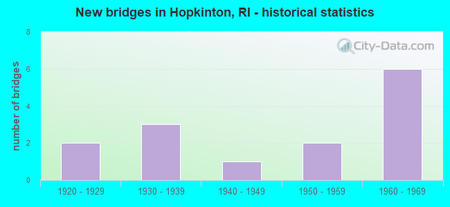
- New bridges - historical statistics
- 21920-1929
- 31930-1939
- 11940-1949
- 21950-1959
- 61960-1969

- Reconstructed bridges - Historical Statistics
- 11930-1939
- 01940-1949
- 01950-1959
- 01960-1969
- 01970-1979
- 01980-1989
- 01990-1999
- 12000-2009


- Bridge Condition - Deck
- 8.3%Very good
- 16.7%Good
- 25.0%Satisfactory
- 41.7%Fair
- 8.3%Poor

- Bridge Condition - Superstructure
- 8.3%Very good
- 41.7%Satisfactory
- 41.7%Fair
- 8.3%Poor

- Bridge Condition - Substructure
- 50.0%Satisfactory
- 50.0%Fair

- Bridge Condition - Channel
- 11.1%Good
- 66.7%Satisfactory
- 22.2%Fair
Find on map >> Show street view
Structure Number: 41, Location: 3.6 Mi S of JCT RI 165 (Lat: 41.540511, Lng: -71.696078), Route carried "on" structure: State highway , Year Built: 1925, Year Reconstructed: 1939, Status: Open, Structure Length: 1.46m (4.79ft), Average Daily Traffic: 573 (year 2014), Truck Traffic: 10%, Average Future Daily Traffic: 688 (year 2036), Design Load: HS 20, Features Intersected: WOOD RIVER, Facility Carried by Structure: ARCADIA RD
Minimum Vertical Clearance: 30+ m (98+ ft), Kilometerpoint: 3.180, Lanes on structure: 2, Owner: State Highway Agency, Approaching Roadway Width: 6.7m (22.0ft), Material/Design: Concrete, Design/Construction: Slab, Number Of Spans In Main Unit: 2, Length of Maximum Span: 5.8m (19.0ft), Curb-To-Curb Width: 6.7m (22.0ft), Out-to-Out Width: 7.3m (24.0ft)
Condition: Deck: Fair, Superstructure: Fair, Substructure: Fair, Channel: Fair, Operating Rating: 32.1 metric tons, Method Used To Determine Operating Rating: Load and Resistance Factor Rating (LRFR) rating reported by rating factor(RF) method using HL-93 loadings, Inventory Rating: 24.6 metric tons, Method Used To Determine Inventory Rating: Load and Resistance Factor Rating (LRFR) rating reported by rating factor(RF) method using HL-93 loadings, Structural Evaluation: Somewhat better than minimum adequacy, Deck Geometry: Meets minimum limits, Waterway Adequacy: Equal to present desirable criteria, Approach Roadway Alignment: Equal to present minimum criteria, Length Of Structure Improvement: 1.46m (4.79ft), Designated Inspection Frequency: Every 24 months, Inspection Date: September 2021, Bridge Improvement Cost: $1,290,000, Roadway Improvement Cost: $129,000, Total Project Cost: $1,935,000, Deck Structure Type: Concrete Cast-file-Place, Wearing Surface/Protective System: Wearing Surface: Bituminous
Find on map >> Show street view
Structure Number: 48, Location: 0.1 Mi E of CONN LINE (Lat: 41.443289, Lng: -71.796256), Route carried "on" structure: State highway , Year Built: 1934, Status: Posted for load-capacity, Structure Length: 1.83m (6.00ft), Average Daily Traffic: 180 (year 2021), Truck Traffic: 19%, Average Future Daily Traffic: 198 (year 2041), Design Load: HS 20, Features Intersected: ASHAWAY RIVER, Facility Carried by Structure: NEW LONDON TRNPK
Minimum Vertical Clearance: 30+ m (98+ ft), Kilometerpoint: 0.042, Lanes on structure: 2, Owner: State Highway Agency, Approaching Roadway Width: 9.8m (32.2ft), Material/Design: Concrete, Design/Construction: Slab, Number Of Spans In Main Unit: 2, Length of Maximum Span: 8.4m (27.6ft), Curb or Sidewalk Widths: Left: 1.5m (4.9ft), Right: 1.5m (4.9ft), Curb-To-Curb Width: 12.3m (40.4ft), Out-to-Out Width: 16.2m (53.1ft)
Condition: Deck: Poor, Superstructure: Poor, Substructure: Fair, Channel: Fair, Operating Rating: 47.9 metric tons, Method Used To Determine Operating Rating: Load and Resistance Factor (LRFR), Inventory Rating: 37.0 metric tons, Method Used To Determine Inventory Rating: Load and Resistance Factor (LRFR), Structural Evaluation: Meets minimum limits, Deck Geometry: Superior to present desirable criteria, Waterway Adequacy: Superior to present desirable criteria, Approach Roadway Alignment: Equal to present desirable criteria, Length Of Structure Improvement: 1.83m (6.00ft), Designated Inspection Frequency: Every 24 months, Other Special Inspection Frequency: Every 12 months, Inspection Date: April 2021, Other Special Inspection Date: April 2021, Bridge Improvement Cost: $1,696,000, Roadway Improvement Cost: $170,000, Total Project Cost: $2,544,000, Deck Structure Type: Concrete Cast-file-Place, Wearing Surface/Protective System: Wearing Surface: Bituminous, Membrane: Built-up
Find on map >> Show street view
Structure Number: 194, Location: 0.5 Mi W of JCT RI 216 (Lat: 41.407442, Lng: -71.748336), Route carried "on" structure: State highway 91, Year Built: 1930, Status: Open, Structure Length: 2.01m (6.59ft), Average Daily Traffic: 6,243 (year 2021), Truck Traffic: 9%, Average Future Daily Traffic: 6,867 (year 2041), Design Load: H 20, Features Intersected: PAWCATUCK RIVER
Minimum Vertical Clearance: 30+ m (98+ ft), Kilometerpoint: 9.683, Lanes on structure: 2, Owner: State Highway Agency, Approaching Roadway Width: 14.0m (45.9ft), Material/Design: Concrete, Design/Construction: Slab, Number Of Spans In Main Unit: 3, Length of Maximum Span: 6.4m (21.0ft), Curb-To-Curb Width: 14.0m (45.9ft), Out-to-Out Width: 15.8m (51.8ft)
Condition: Deck: Fair, Superstructure: Fair, Substructure: Fair, Channel: Satisfactory, Operating Rating: 39.9 metric tons, Method Used To Determine Operating Rating: Load and Resistance Factor Rating (LRFR) rating reported by rating factor(RF) method using HL-93 loadings, Inventory Rating: 30.8 metric tons, Method Used To Determine Inventory Rating: Load and Resistance Factor Rating (LRFR) rating reported by rating factor(RF) method using HL-93 loadings, Structural Evaluation: Somewhat better than minimum adequacy, Deck Geometry: Superior to present desirable criteria, Waterway Adequacy: Superior to present desirable criteria, Approach Roadway Alignment: Better than present minimum criteria, Length Of Structure Improvement: 2.01m (6.59ft), Designated Inspection Frequency: Every 24 months, Underwater Inspection Frequency: Every 48 months, Inspection Date: November 2021, Underwater Inspection Date: November 2021, Total Project Cost: $996,000, Deck Structure Type: Concrete Cast-file-Place, Wearing Surface/Protective System: Wearing Surface: Bituminous
Find on map >> Show street view
Structure Number: 199, Location: 0.5 Mi N of JCT RI 78 (Lat: 41.399392, Lng: -71.799789), Route carried "on" structure: Alternate State highway 3, Year Built: 1924, Status: Open, Structure Length: 2.65m (8.69ft), Average Daily Traffic: 8,452 (year 2021), Truck Traffic: 11%, Average Future Daily Traffic: 9,297 (year 2041), Design Load: HS 20, Features Intersected: PAWCATUCK RIVER
Minimum Vertical Clearance: 30+ m (98+ ft), Kilometerpoint: 4.131, Lanes on structure: 2, Base Highway Network: Yes, Owner: State Highway Agency, Approaching Roadway Width: 9.1m (29.9ft), Skew: 2 degrees, Material/Design: Concrete, Design/Construction: Arch - Deck, Number Of Spans In Main Unit: 1, Length of Maximum Span: 24.4m (80.1ft), Curb or Sidewalk Widths: Left: 2.0m (6.6ft), Right: 2.0m (6.6ft), Curb-To-Curb Width: 9.1m (29.9ft), Out-to-Out Width: 14.2m (46.6ft)
Condition: Deck: Fair, Superstructure: Fair, Substructure: Fair, Channel: Satisfactory, Operating Rating: 82.3 metric tons, Method Used To Determine Operating Rating: Load and Resistance Factor Rating (LRFR) rating reported by rating factor(RF) method using HL-93 loadings, Inventory Rating: 63.5 metric tons, Method Used To Determine Inventory Rating: Load and Resistance Factor Rating (LRFR) rating reported by rating factor(RF) method using HL-93 loadings, Structural Evaluation: Somewhat better than minimum adequacy, Deck Geometry: High priority of corrective action, Waterway Adequacy: Superior to present desirable criteria, Approach Roadway Alignment: Equal to present minimum criteria, Length Of Structure Improvement: 2.44m (8.01ft), Designated Inspection Frequency: Every 24 months, Underwater Inspection Frequency: Every 48 months, Inspection Date: October 2021, Underwater Inspection Date: October 2021, Bridge Improvement Cost: $3,439,000, Roadway Improvement Cost: $344,000, Total Project Cost: $5,159,000, Deck Structure Type: Concrete Cast-file-Place, Wearing Surface/Protective System: Wearing Surface: Bituminous, Membrane: Built-up
Find on map >> Show street view
Structure Number: 261, Location: 2.5 Mi N of JCT RI 216 (Lat: 41.437778, Lng: -71.722333), Route carried "on" structure: State highway 91, Year Built: 1931, Status: Open, Structure Length: 4.64m (15.22ft), Average Daily Traffic: 6,768 (year 2015), Truck Traffic: 10%, Average Future Daily Traffic: 8,122 (year 2036), Design Load: HS 20, Features Intersected: WOOD RIVER
Minimum Vertical Clearance: 30+ m (98+ ft), Kilometerpoint: 14.022, Lanes on structure: 2, Owner: State Highway Agency, Approaching Roadway Width: 12.2m (40.0ft), Material/Design: Concrete, Design/Construction: Slab, Number Of Spans In Main Unit: 6, Length of Maximum Span: 7.4m (24.3ft), Curb or Sidewalk Widths: Left: 1.8m (5.9ft), Right: 1.8m (5.9ft), Curb-To-Curb Width: 12.3m (40.4ft), Out-to-Out Width: 17.7m (58.1ft)
Condition: Deck: Satisfactory, Superstructure: Satisfactory, Substructure: Satisfactory, Channel: Satisfactory, Operating Rating: 59.0 metric tons, Method Used To Determine Operating Rating: Load and Resistance Factor Rating (LRFR) rating reported by rating factor(RF) method using HL-93 loadings, Inventory Rating: 45.4 metric tons, Method Used To Determine Inventory Rating: Load and Resistance Factor Rating (LRFR) rating reported by rating factor(RF) method using HL-93 loadings, Structural Evaluation: Equal to present minimum criteria, Deck Geometry: Somewhat better than minimum adequacy, Waterway Adequacy: Equal to present desirable criteria, Approach Roadway Alignment: Equal to present minimum criteria, Length Of Structure Improvement: 4.75m (15.58ft), Designated Inspection Frequency: Every 24 months, Underwater Inspection Frequency: Every 48 months, Inspection Date: October 2021, Underwater Inspection Date: October 2021, Bridge Improvement Cost: $2,211,000, Roadway Improvement Cost: $221,000, Total Project Cost: $3,317,000, Deck Structure Type: Concrete Cast-file-Place, Wearing Surface/Protective System: Wearing Surface: Bituminous, Membrane: Other
Find on map >> Show street view
Structure Number: 363, Location: 1.3 Mi E of JCT I-95 (Lat: 41.460136, Lng: -71.718633), Route carried "on" structure: City street , Year Built: 1949, Year Reconstructed: 2011, Status: Open, Structure Length: 3.52m (11.55ft), Average Daily Traffic: 850 (year 2021), Truck Traffic: 9%, Average Future Daily Traffic: 935 (year 2041), Design Load: HL 93, Features Intersected: WOOD RIVER, Facility Carried by Structure: WOODVILLE RD
Minimum Vertical Clearance: 5.18m (16.99ft), Kilometerpoint: 5.164, Lanes on structure: 2, Owner: State Highway Agency, Approaching Roadway Width: 7.9m (25.9ft), Skew: 2 degrees, Material/Design: Steel continuous, Design/Construction: Stringer/Multi-beam, Number Of Spans In Main Unit: 4, Length of Maximum Span: 8.6m (28.2ft), Curb or Sidewalk Widths: Left: 1.5m (4.9ft), Right: 0.3m (1.0ft), Curb-To-Curb Width: 7.9m (25.9ft), Out-to-Out Width: 10.4m (34.1ft)
Condition: Deck: Very good, Superstructure: Very good, Substructure: Satisfactory, Channel: Good, Operating Rating: 62.2 metric tons, Method Used To Determine Operating Rating: Load and Resistance Factor Rating (LRFR) rating reported by rating factor(RF) method using HL-93 loadings, Inventory Rating: 48.0 metric tons, Method Used To Determine Inventory Rating: Load and Resistance Factor Rating (LRFR) rating reported by rating factor(RF) method using HL-93 loadings, Structural Evaluation: Equal to present minimum criteria, Deck Geometry: Somewhat better than minimum adequacy, Waterway Adequacy: Better than present minimum criteria, Approach Roadway Alignment: Somewhat better than minimum adequacy, Length Of Structure Improvement: 3.29m (10.79ft), Designated Inspection Frequency: Every 24 months, Underwater Inspection Frequency: Every 48 months, Inspection Date: November 2021, Underwater Inspection Date: November 2021, Bridge Improvement Cost: $156,000, Roadway Improvement Cost: $16,000, Total Project Cost: $234,000, Deck Structure Type: Concrete Cast-file-Place, Wearing Surface/Protective System: Wearing Surface: Bituminous, Membrane: Built-up
Find on map >> Show street view
Structure Number: 404, Location: 0.3 Mi N of Water St (Lat: 41.495150, Lng: -71.716142), Route carried "on" structure: Interstate 95, Year Built: 1953, Status: Open, Structure Length: 8.20m (26.90ft), Average Daily Traffic: 49,247 (year 2015), Truck Traffic: 8%, Average Future Daily Traffic: 59,097 (year 2036), Design Load: HS 20, Features Intersected: WOOD RIVER & MECHANIC ST
Minimum Vertical Clearance: 30+ m (98+ ft), Kilometerpoint: 8.988, Lanes on structure: 4, Lanes under structure: 2, Base Highway Network: Yes, Owner: State Highway Agency, Approaching Roadway Width: 25.9m (85.0ft), Skew: 35 degrees, Material/Design: Concrete continuous, Design/Construction: Tee Beam, Number Of Spans In Main Unit: 4, Length of Maximum Span: 23.2m (76.1ft), Curb-To-Curb Width: 25.9m (85.0ft), Out-to-Out Width: 29.0m (95.1ft)
Condition: Deck: Satisfactory, Superstructure: Satisfactory, Substructure: Satisfactory, Channel: Satisfactory, Operating Rating: 51.2 metric tons, Method Used To Determine Operating Rating: Load and Resistance Factor Rating (LRFR) rating reported by rating factor(RF) method using HL-93 loadings, Inventory Rating: 39.5 metric tons, Method Used To Determine Inventory Rating: Load and Resistance Factor Rating (LRFR) rating reported by rating factor(RF) method using HL-93 loadings, Structural Evaluation: Equal to present minimum criteria, Deck Geometry: Superior to present desirable criteria, Underclear: Better than present minimum criteria, Waterway Adequacy: Superior to present desirable criteria, Approach Roadway Alignment: Better than present minimum criteria, Length Of Structure Improvement: 8.20m (26.90ft), Designated Inspection Frequency: Every 24 months, Inspection Date: December 2021, Bridge Improvement Cost: $13,004,000, Roadway Improvement Cost: $1,300,000, Total Project Cost: $19,506,000, Deck Structure Type: Concrete Cast-file-Place, Wearing Surface/Protective System: Deck Protection: Galvanized Reinforcing
Find on map >> Show street view
Structure Number: 405, Location: 0.3 Mi N of Conn Line (Lat: 41.448414, Lng: -71.786419), Route carried "on" structure: State highway 3, Year Built: 1952, Status: Open, Structure Length: 3.61m (11.84ft), Average Daily Traffic: 9,396 (year 2015), Truck Traffic: 2%, Average Future Daily Traffic: 11,276 (year 2036), Design Load: HS 20, Features Intersected: I-95 NB & SB
Minimum Vertical Clearance: 30+ m (98+ ft), Kilometerpoint: 9.997, Lanes on structure: 2, Lanes under structure: 6, Base Highway Network: Yes, Owner: State Highway Agency, Approaching Roadway Width: 15.2m (49.9ft), Skew: 3 degrees, Material/Design: Concrete continuous, Design/Construction: Frame, Number Of Spans In Main Unit: 2, Length of Maximum Span: 15.1m (49.5ft), Curb or Sidewalk Widths: Left: 1.6m (5.2ft), Right: 1.6m (5.2ft), Curb-To-Curb Width: 15.2m (49.9ft), Out-to-Out Width: 18.6m (61.0ft)
Condition: Deck: Fair, Superstructure: Fair, Substructure: Satisfactory, Operating Rating: 68.7 metric tons, Method Used To Determine Operating Rating: Load and Resistance Factor Rating (LRFR) rating reported by rating factor(RF) method using HL-93 loadings, Inventory Rating: 53.1 metric tons, Method Used To Determine Inventory Rating: Load and Resistance Factor Rating (LRFR) rating reported by rating factor(RF) method using HL-93 loadings, Structural Evaluation: Somewhat better than minimum adequacy, Deck Geometry: Superior to present desirable criteria, Underclear: High priority of corrective action, Approach Roadway Alignment: Equal to present desirable criteria, Length Of Structure Improvement: 3.84m (12.60ft), Designated Inspection Frequency: Every 24 months, Other Special Inspection Frequency: Every 12 months, Inspection Date: October 2021, Other Special Inspection Date: October 2021, Bridge Improvement Cost: $663,000, Roadway Improvement Cost: $66,000, Total Project Cost: $995,000, Deck Structure Type: Concrete Cast-file-Place, Wearing Surface/Protective System: Wearing Surface: Bituminous, Membrane: Preformed Fabric
Find on map >> Show street view
Structure Number: 567, Location: 0.5 Mi S of RI 3 (Lat: 41.485719, Lng: -71.733022), Route carried "on" structure: City street , Year Built: 1969, Status: Open, Structure Length: 4.33m (14.21ft), Average Daily Traffic: 3,600 (year 2021), Truck Traffic: 11%, Average Future Daily Traffic: 3,960 (year 2041), Design Load: HS 20, Features Intersected: I-95 NB & SB, Facility Carried by Structure: Woodville-Alton Rd
Minimum Vertical Clearance: 30+ m (98+ ft), Kilometerpoint: 5.708, Lanes on structure: 2, Lanes under structure: 5, Owner: State Highway Agency, Approaching Roadway Width: 19.5m (64.0ft), Skew: 20 degrees, Material/Design: Steel continuous, Design/Construction: Stringer/Multi-beam, Number Of Spans In Main Unit: 2, Length of Maximum Span: 23.5m (77.1ft), Curb-To-Curb Width: 15.2m (49.9ft), Out-to-Out Width: 20.6m (67.6ft)
Condition: Deck: Satisfactory, Superstructure: Fair, Substructure: Fair, Operating Rating: 40.2 metric tons, Method Used To Determine Operating Rating: Load and Resistance Factor Rating (LRFR) rating reported by rating factor(RF) method using HL-93 loadings, Inventory Rating: 28.8 metric tons, Method Used To Determine Inventory Rating: Load and Resistance Factor Rating (LRFR) rating reported by rating factor(RF) method using HL-93 loadings, Structural Evaluation: Somewhat better than minimum adequacy, Deck Geometry: Superior to present desirable criteria, Underclear: Meets minimum limits, Approach Roadway Alignment: Equal to present desirable criteria, Length Of Structure Improvement: 4.33m (14.21ft), Designated Inspection Frequency: Every 24 months, Inspection Date: December 2021, Bridge Improvement Cost: $1,856,000, Roadway Improvement Cost: $186,000, Total Project Cost: $2,784,000, Deck Structure Type: Concrete Cast-file-Place, Wearing Surface/Protective System: Wearing Surface: Bituminous, Membrane: Preformed Fabric
Find on map >> Show street view
Structure Number: 568, Location: 1.3 Mi N of CONN LINE (Lat: 41.460086, Lng: -71.771850), Route carried "on" structure: City street , Year Built: 1969, Status: Open, Structure Length: 4.94m (16.21ft), Average Daily Traffic: 700 (year 2015), Truck Traffic: 10%, Average Future Daily Traffic: 840 (year 2036), Design Load: HS 20, Features Intersected: I-95 NB & SB, Facility Carried by Structure: WOODVILLE RD
Minimum Vertical Clearance: 30+ m (98+ ft), Kilometerpoint: 0.542, Lanes on structure: 2, Lanes under structure: 4, Owner: State Highway Agency, Approaching Roadway Width: 14.6m (47.9ft), Skew: 3 degrees, Material/Design: Steel continuous, Design/Construction: Stringer/Multi-beam, Number Of Spans In Main Unit: 2, Length of Maximum Span: 24.1m (79.1ft), Curb-To-Curb Width: 14.6m (47.9ft), Out-to-Out Width: 15.7m (51.5ft)
Condition: Deck: Fair, Superstructure: Satisfactory, Substructure: Fair, Operating Rating: 43.4 metric tons, Method Used To Determine Operating Rating: Load and Resistance Factor Rating (LRFR) rating reported by rating factor(RF) method using HL-93 loadings, Inventory Rating: 33.4 metric tons, Method Used To Determine Inventory Rating: Load and Resistance Factor Rating (LRFR) rating reported by rating factor(RF) method using HL-93 loadings, Structural Evaluation: Somewhat better than minimum adequacy, Deck Geometry: Superior to present desirable criteria, Underclear: Meets minimum limits, Approach Roadway Alignment: Better than present minimum criteria, Length Of Structure Improvement: 4.94m (16.21ft), Designated Inspection Frequency: Every 24 months, Inspection Date: August 2021, Bridge Improvement Cost: $1,615,000, Roadway Improvement Cost: $161,000, Total Project Cost: $2,422,000, Deck Structure Type: Concrete Cast-file-Place, Wearing Surface/Protective System: Wearing Surface: Bituminous, Membrane: Preformed Fabric
Find on map >> Show street view
Structure Number: 569, Location: 0.5 Mi N of Conn Line (Lat: 41.442853, Lng: -71.795736), Route carried "on" structure: Interstate 95, Year Built: 1965, Status: Open, Structure Length: 1.68m (5.51ft), Average Daily Traffic: 40,800 (year 2021), Truck Traffic: 16%, Average Future Daily Traffic: 44,880 (year 2041), Design Load: HS 20, Features Intersected: ASHAWAY RIVER
Minimum Vertical Clearance: 30+ m (98+ ft), Kilometerpoint: 0.108, Lanes on structure: 2, Base Highway Network: Yes, Owner: State Highway Agency, Approaching Roadway Width: 11.6m (38.1ft), Material/Design: Prestressed concrete, Design/Construction: Stringer/Multi-beam, Number Of Spans In Main Unit: 1, Length of Maximum Span: 15.5m (50.9ft), Curb-To-Curb Width: 11.6m (38.1ft), Out-to-Out Width: 13.4m (44.0ft)
Condition: Deck: Good, Superstructure: Satisfactory, Substructure: Satisfactory, Channel: Satisfactory, Operating Rating: 68.7 metric tons, Method Used To Determine Operating Rating: Load and Resistance Factor Rating (LRFR) rating reported by rating factor(RF) method using HL-93 loadings, Inventory Rating: 42.1 metric tons, Method Used To Determine Inventory Rating: Load and Resistance Factor Rating (LRFR) rating reported by rating factor(RF) method using HL-93 loadings, Structural Evaluation: Equal to present minimum criteria, Deck Geometry: Equal to present minimum criteria, Waterway Adequacy: Equal to present desirable criteria, Approach Roadway Alignment: Equal to present desirable criteria, Length Of Structure Improvement: 1.65m (5.41ft), Designated Inspection Frequency: Every 24 months, Inspection Date: June 2021, Bridge Improvement Cost: $468,000, Roadway Improvement Cost: $47,000, Total Project Cost: $702,000, Deck Structure Type: Concrete Cast-file-Place, Wearing Surface/Protective System: Wearing Surface: Bituminous, Membrane: Preformed Fabric
Find on map >> Show street view
Structure Number: 5692, Location: 0.5 Mi N of Conn Line (Lat: 41.442997, Lng: -71.795917), Route carried "on" structure: Interstate 95, Year Built: 1965, Status: Open, Structure Length: 1.68m (5.51ft), Average Daily Traffic: 18,300 (year 2021), Truck Traffic: 9%, Average Future Daily Traffic: 20,130 (year 2041), Design Load: HS 20, Features Intersected: ASHAWAY RIVER
Minimum Vertical Clearance: 30+ m (98+ ft), Kilometerpoint: 69.562, Lanes on structure: 2, Base Highway Network: Yes, Owner: State Highway Agency, Approaching Roadway Width: 11.6m (38.1ft), Skew: 10 degrees, Material/Design: Prestressed concrete, Design/Construction: Stringer/Multi-beam, Number Of Spans In Main Unit: 1, Length of Maximum Span: 15.5m (50.9ft), Curb-To-Curb Width: 11.6m (38.1ft), Out-to-Out Width: 13.4m (44.0ft)
Condition: Deck: Good, Superstructure: Satisfactory, Substructure: Satisfactory, Channel: Satisfactory, Operating Rating: 68.7 metric tons, Method Used To Determine Operating Rating: Load and Resistance Factor Rating (LRFR) rating reported by rating factor(RF) method using HL-93 loadings, Inventory Rating: 42.1 metric tons, Method Used To Determine Inventory Rating: Load and Resistance Factor Rating (LRFR) rating reported by rating factor(RF) method using HL-93 loadings, Structural Evaluation: Equal to present minimum criteria, Deck Geometry: Equal to present minimum criteria, Waterway Adequacy: Equal to present desirable criteria, Approach Roadway Alignment: Equal to present desirable criteria, Length Of Structure Improvement: 1.65m (5.41ft), Designated Inspection Frequency: Every 24 months, Inspection Date: June 2021, Bridge Improvement Cost: $468,000, Roadway Improvement Cost: $47,000, Total Project Cost: $702,000, Deck Structure Type: Concrete Cast-file-Place, Wearing Surface/Protective System: Wearing Surface: Bituminous, Membrane: Preformed Fabric
Find on map >> Show street view
Structure Number: 567, Location: 0.5 Mi S of RI 3 (Lat: 41.485719, Lng: -71.733022), Route carried "under" structure: Interstate 95, Year Built: 1969, Structure Length: 0. m, Average Daily Traffic: 3,600 (year 2021), Truck Traffic: 11%, Features Intersected: I-95 NB & SB, Facility Carried by Structure: Woodville-Alton Rd
Minimum Vertical Clearance: 4.92m (16.14ft), Kilometerpoint: 0.000, Lanes on structure: 2, Lanes under structure: 5, Material/Design: Steel continuous, Design/Construction: Stringer/Multi-beam, Length of Maximum Span: 23.5m (77.1ft)
Find on map >> Show street view
Structure Number: 568, Location: 1.3 Mi N of CONN LINE (Lat: 41.460086, Lng: -71.771850), Route carried "under" structure: Interstate 95, Year Built: 1969, Structure Length: 0. m, Average Daily Traffic: 30,500 (year 2008), Truck Traffic: 10%, Features Intersected: I-95 NB & SB, Facility Carried by Structure: WOODVILLE RD
Minimum Vertical Clearance: 4.85m (15.91ft), Kilometerpoint: 0.000, Lanes on structure: 2, Lanes under structure: 4, Material/Design: Steel continuous, Design/Construction: Stringer/Multi-beam, Length of Maximum Span: 24.1m (79.1ft)