Bridge Statistics for Hoffman Estates, Illinois (IL)
Condition, Traffic, Stress, Structural Evaluation, Project Costs
- National Bridge Inventory (NBI) Statistics
- 36Number of bridges
- 299ft / 91.2mTotal length
- $767,000Total costs
- 1,459,800Total average daily traffic
- 142,516Total average daily truck traffic
- National Bridge Inventory (NBI) Registered Bridges for Hoffman Estates
- No street view available for this location
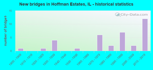
- New bridges - historical statistics
- 11900-1909
- 11920-1929
- 41930-1939
- 11950-1959
- 61970-1979
- 21980-1989
- 71990-1999
- 22000-2009
- 122010-2019

- Reconstructed bridges - Historical Statistics
- 31970-1979
- 01980-1989
- 01990-1999
- 32000-2009
- 12010-2019


- Bridge Condition - Deck
- 30.8%Very good
- 38.5%Good
- 30.8%Satisfactory

- Bridge Condition - Superstructure
- 46.2%Very good
- 15.4%Good
- 30.8%Satisfactory
- 7.7%Fair

- Bridge Condition - Substructure
- 46.2%Very good
- 30.8%Good
- 15.4%Satisfactory
- 7.7%Fair

- Bridge Condition - Channel
- 5.6%Very good
- 27.8%Good
- 55.6%Satisfactory
- 5.6%Fair
- 5.6%Poor

- Bridge Condition - Culverts
- 20.0%Very good
- 20.0%Good
- 40.0%Satisfactory
- 20.0%Fair
Find on map >> Show street view
Structure Number: 160502, Location: .65 M NW IL 59 (Lat: 42.077636, Lng: -88.201192), Route carried "on" structure: State highway 72, Year Built: 1938, Year Reconstructed: 1979, Status: Open, Structure Length: 4.79m (15.72ft), Average Daily Traffic: 19,000 (year 2021), Truck Traffic: 6%, Average Future Daily Traffic: 13,545 (year 2032), Design Load: HS 20, Features Intersected: RR - WI CENTRAL LTD
Minimum Vertical Clearance: 30+ m (98+ ft), Kilometerpoint: 142.053, Lanes on structure: 2, Base Highway Network: Yes, Owner: State Highway Agency, Approaching Roadway Width: 12.8m (42.0ft), Material/Design: Steel continuous, Design/Construction: Stringer/Multi-beam, Number Of Spans In Main Unit: 3, Length of Maximum Span: 18.3m (60.0ft), Curb-To-Curb Width: 12.8m (42.0ft), Out-to-Out Width: 13.8m (45.3ft)
Condition: Deck: Good, Superstructure: Fair, Substructure: Good, Operating Rating: 68.7 metric tons, Method Used To Determine Operating Rating: Load Factor (LF) rating reported by rating factor (RF) method using MS18 loading, Inventory Rating: 41.1 metric tons, Method Used To Determine Inventory Rating: Load Factor (LF) rating reported by rating factor (RF) method using MS18 loading, Structural Evaluation: Somewhat better than minimum adequacy, Deck Geometry: Equal to present desirable criteria, Underclear: Equal to present minimum criteria, Approach Roadway Alignment: Equal to present desirable criteria, Designated Inspection Frequency: Every 24 months, Inspection Date: December 2021, Deck Structure Type: Concrete Cast-file-Place, Wearing Surface/Protective System: Deck Protection: Epoxy Coated Reinforcing
Find on map >> Show street view
Structure Number: 160845, Location: 1.5 M E of IL 59 (Lat: 42.066175, Lng: -88.160428), Route carried "on" structure: State highway 72, Year Built: 2015, Status: Open, Structure Length: 17.89m (58.69ft), Average Daily Traffic: 16,600 (year 2021), Truck Traffic: 5%, Average Future Daily Traffic: 19,250 (year 2040), Design Load: HS 25 or greater, Features Intersected: I- 90 ADAMS TOLLWAY
Minimum Vertical Clearance: 30+ m (98+ ft), Kilometerpoint: 145.609, Lanes on structure: 2, Lanes under structure: 3, Base Highway Network: Yes, Owner: State Highway Agency, Approaching Roadway Width: 14.0m (45.9ft), Skew: 6 degrees, Material/Design: Steel continuous, Design/Construction: Stringer/Multi-beam, Number Of Spans In Main Unit: 2, Length of Maximum Span: 85.3m (279.9ft), Curb-To-Curb Width: 14.0m (45.9ft), Out-to-Out Width: 15.0m (49.2ft)
Condition: Deck: Good, Superstructure: Very good, Substructure: Very good, Operating Rating: 89.1 metric tons, Method Used To Determine Operating Rating: Load and Resistance Factor Rating (LRFR) rating reported by rating factor(RF) method using HL-93 loadings, Inventory Rating: 68.7 metric tons, Method Used To Determine Inventory Rating: Load and Resistance Factor Rating (LRFR) rating reported by rating factor(RF) method using HL-93 loadings, Structural Evaluation: Equal to present desirable criteria, Deck Geometry: Superior to present desirable criteria, Approach Roadway Alignment: Equal to present desirable criteria, Designated Inspection Frequency: Every 24 months, Inspection Date: August 2020, Deck Structure Type: Concrete Cast-file-Place, Wearing Surface/Protective System: Deck Protection: Epoxy Coated Reinforcing
Find on map >> Show street view
Structure Number: 161168, Location: 0.2 M SE I-90 (Lat: 42.064867, Lng: -88.155764), Route carried "on" structure: State highway 72, Year Built: 1939, Year Reconstructed: 1970, Status: Open, Structure Length: 0.73m (2.40ft), Average Daily Traffic: 16,600 (year 2021), Truck Traffic: 5%, Average Future Daily Traffic: 23,587 (year 2032), Design Load: HS 20, Features Intersected: POPLAR CREEK
Minimum Vertical Clearance: 30+ m (98+ ft), Kilometerpoint: 146.060, Lanes on structure: 4, Base Highway Network: Yes, Owner: State Highway Agency, Approaching Roadway Width: 24.4m (80.1ft), Skew: 10 degrees, Material/Design: Concrete continuous, Design/Construction: Culvert, Number Of Spans In Main Unit: 2, Length of Maximum Span: 3.6m (11.8ft), Curb-To-Curb Width: 24.4m (80.1ft), Out-to-Out Width: 42.7m (140.1ft)
Condition: Channel: Satisfactory, Culverts: Satisfactory, Operating Rating: 43.7 metric tons, Method Used To Determine Operating Rating: Load Factor (LF) rating reported by rating factor (RF) method using MS18 loading, Inventory Rating: 26.2 metric tons, Method Used To Determine Inventory Rating: Load Factor (LF) rating reported by rating factor (RF) method using MS18 loading, Structural Evaluation: Equal to present minimum criteria, Deck Geometry: Superior to present desirable criteria, Waterway Adequacy: Equal to present desirable criteria, Approach Roadway Alignment: Equal to present desirable criteria, Designated Inspection Frequency: Every 24 months, Inspection Date: March 2021, Deck Structure Type: Other
Find on map >> Show street view
Structure Number: 161719, Location: 6 M W of IL 53 (Lat: 42.066511, Lng: -88.144647), Route carried "on" structure: Other road , Year Built: 2015, Status: Open, Structure Length: 6.51m (21.36ft), Average Daily Traffic: 32,300 (year 2021), Truck Traffic: 3%, Average Future Daily Traffic: 44,000 (year 2040), Design Load: HS 25 or greater, Features Intersected: I- 90 ADAMS TOLLWAY, Facility Carried by Structure: BARRINGTON RD
Minimum Vertical Clearance: 30+ m (98+ ft), Kilometerpoint: 3.444, Lanes on structure: 8, Lanes under structure: 8, Base Highway Network: Yes, Owner: State Highway Agency, Approaching Roadway Width: 21.9m (71.9ft), Skew: 30 degrees, Material/Design: Prestressed concrete continuous, Design/Construction: Stringer/Multi-beam, Number Of Spans In Main Unit: 2, Length of Maximum Span: 28.3m (92.8ft), Curb or Sidewalk Widths: Left: 3.0m (9.8ft), Right: 3.0m (9.8ft), Curb-To-Curb Width: 29.3m (96.1ft), Out-to-Out Width: 53.4m (175.2ft)
Condition: Deck: Very good, Superstructure: Very good, Substructure: Good, Operating Rating: 51.2 metric tons, Method Used To Determine Operating Rating: Load and Resistance Factor Rating (LRFR) rating reported by rating factor(RF) method using HL-93 loadings, Inventory Rating: 39.5 metric tons, Method Used To Determine Inventory Rating: Load and Resistance Factor Rating (LRFR) rating reported by rating factor(RF) method using HL-93 loadings, Structural Evaluation: Better than present minimum criteria, Deck Geometry: Meets minimum limits, Approach Roadway Alignment: Equal to present desirable criteria, Designated Inspection Frequency: Every 24 months, Inspection Date: August 2019, Deck Structure Type: Concrete Cast-file-Place, Wearing Surface/Protective System: Deck Protection: Epoxy Coated Reinforcing
Find on map >> Show street view
Structure Number: 162087, Location: .06 M W IL 59 (Lat: 42.045447, Lng: -88.195256), Route carried "on" structure: State highway 58, Year Built: 1977, Year Reconstructed: 2008, Status: Open, Structure Length: 2.93m (9.61ft), Average Daily Traffic: 11,500 (year 2021), Truck Traffic: 2%, Average Future Daily Traffic: 13,596 (year 2032), Design Load: HS 20, Features Intersected: POPLAR CREEK
Minimum Vertical Clearance: 30+ m (98+ ft), Kilometerpoint: 5.938, Lanes on structure: 4, Base Highway Network: Yes, Owner: State Highway Agency, Approaching Roadway Width: 7.9m (25.9ft), Skew: 34 degrees, Material/Design: Prestressed concrete, Design/Construction: Box Beam or Girders - Multiple, Number Of Spans In Main Unit: 2, Length of Maximum Span: 13.5m (44.3ft), Curb-To-Curb Width: 17.3m (56.8ft), Out-to-Out Width: 22.6m (74.1ft)
Condition: Deck: Satisfactory, Superstructure: Satisfactory, Substructure: Good, Channel: Good, Operating Rating: 57.3 metric tons, Method Used To Determine Operating Rating: Load Factor (LF) rating reported by rating factor (RF) method using MS18 loading, Inventory Rating: 34.3 metric tons, Method Used To Determine Inventory Rating: Load Factor (LF) rating reported by rating factor (RF) method using MS18 loading, Structural Evaluation: Equal to present minimum criteria, Deck Geometry: Somewhat better than minimum adequacy, Waterway Adequacy: Better than present minimum criteria, Approach Roadway Alignment: Equal to present desirable criteria, Length Of Structure Improvement: 2.93m (9.61ft), Designated Inspection Frequency: Every 24 months, Inspection Date: October 2020, Bridge Improvement Cost: $511,000, Roadway Improvement Cost: $51,000, Total Project Cost: $767,000, Deck Structure Type: Concrete Cast-file-Place, Wearing Surface/Protective System: Wearing Surface: Other, Deck Protection: Epoxy Coated Reinforcing
Find on map >> Show street view
Structure Number: 162088, Location: .01 M S IL 58 (Lat: 42.045161, Lng: -88.194072), Route carried "on" structure: State highway 59, Year Built: 1977, Status: Open, Structure Length: 1.98m (6.50ft), Average Daily Traffic: 35,900 (year 2021), Truck Traffic: 10%, Average Future Daily Traffic: 37,801 (year 2032), Design Load: HS 20, Features Intersected: POPLAR CREEK
Minimum Vertical Clearance: 30+ m (98+ ft), Kilometerpoint: 60.928, Lanes on structure: 4, Base Highway Network: Yes, Owner: State Highway Agency, Approaching Roadway Width: 17.7m (58.1ft), Skew: 31 degrees, Material/Design: Concrete continuous, Design/Construction: Culvert, Number Of Spans In Main Unit: 5, Length of Maximum Span: 4.1m (13.5ft), Curb or Sidewalk Widths: Left: 0.0m, Right: 3.4m (11.2ft)
Condition: Channel: Fair, Culverts: Satisfactory, Operating Rating: 81.6 metric tons, Method Used To Determine Operating Rating: Load Factor (LF) rating reported by rating factor (RF) method using MS18 loading, Inventory Rating: 48.9 metric tons, Method Used To Determine Inventory Rating: Load Factor (LF) rating reported by rating factor (RF) method using MS18 loading, Structural Evaluation: Equal to present minimum criteria, Waterway Adequacy: Equal to present desirable criteria, Approach Roadway Alignment: Equal to present desirable criteria, Designated Inspection Frequency: Every 24 months, Inspection Date: June 2020
Find on map >> Show street view
Structure Number: 162502, Location: 0.2 M E BARRINGTON (Lat: 42.058156, Lng: -88.140461), Route carried "on" structure: State highway 72, Year Built: 1970, Status: Open, Structure Length: 1.23m (4.04ft), Average Daily Traffic: 22,300 (year 2021), Truck Traffic: 3%, Average Future Daily Traffic: 27,192 (year 2032), Design Load: HS 20, Features Intersected: POPLAR CREEK
Minimum Vertical Clearance: 30+ m (98+ ft), Kilometerpoint: 147.525, Lanes on structure: 4, Base Highway Network: Yes, Owner: State Highway Agency, Approaching Roadway Width: 23.6m (77.4ft), Skew: 11 degrees, Material/Design: Concrete continuous, Design/Construction: Culvert, Number Of Spans In Main Unit: 3, Length of Maximum Span: 3.9m (12.8ft), Curb or Sidewalk Widths: Left: 1.5m (4.9ft), Right: 1.5m (4.9ft)
Condition: Channel: Satisfactory, Culverts: Satisfactory, Operating Rating: 94.6 metric tons, Method Used To Determine Operating Rating: Load Factor (LF) rating reported by rating factor (RF) method using MS18 loading, Inventory Rating: 56.7 metric tons, Method Used To Determine Inventory Rating: Load Factor (LF) rating reported by rating factor (RF) method using MS18 loading, Structural Evaluation: Equal to present minimum criteria, Waterway Adequacy: Better than present minimum criteria, Approach Roadway Alignment: Equal to present desirable criteria, Designated Inspection Frequency: Every 24 months, Inspection Date: March 2021
Find on map >> Show street view
Structure Number: 162514, Location: 1 M W IL 59 (Lat: 42.044972, Lng: -88.214572), Route carried "on" structure: State highway 58, Year Built: 1978, Year Reconstructed: 2009, Status: Open, Structure Length: 1.81m (5.94ft), Average Daily Traffic: 11,500 (year 2021), Truck Traffic: 2%, Average Future Daily Traffic: 13,596 (year 2032), Design Load: HS 20, Features Intersected: POPLAR CREEK
Minimum Vertical Clearance: 30+ m (98+ ft), Kilometerpoint: 4.329, Lanes on structure: 2, Base Highway Network: Yes, Owner: State Highway Agency, Approaching Roadway Width: 7.9m (25.9ft), Material/Design: Prestressed concrete, Design/Construction: Box Beam or Girders - Multiple, Number Of Spans In Main Unit: 1, Length of Maximum Span: 16.8m (55.1ft), Curb-To-Curb Width: 25.5m (83.7ft), Out-to-Out Width: 26.5m (86.9ft)
Condition: Deck: Good, Superstructure: Satisfactory, Substructure: Fair, Channel: Satisfactory, Operating Rating: 70.3 metric tons, Method Used To Determine Operating Rating: Load Factor (LF) rating reported by rating factor (RF) method using MS18 loading, Inventory Rating: 42.1 metric tons, Method Used To Determine Inventory Rating: Load Factor (LF) rating reported by rating factor (RF) method using MS18 loading, Structural Evaluation: Somewhat better than minimum adequacy, Deck Geometry: Superior to present desirable criteria, Waterway Adequacy: Better than present minimum criteria, Approach Roadway Alignment: Equal to present desirable criteria, Designated Inspection Frequency: Every 24 months, Other Special Inspection Frequency: Every 24 months, Inspection Date: October 2020, Other Special Inspection Date: October 2020, Deck Structure Type: Concrete Cast-file-Place, Wearing Surface/Protective System: Wearing Surface: Integral Concrete, Deck Protection: Epoxy Coated Reinforcing
Find on map >> Show street view
Structure Number: 162596, Location: .65 M W OF IL 59 (Lat: 42.077636, Lng: -88.201192), Route carried "on" structure: State highway 72, Year Built: 1991, Status: Open, Structure Length: 4.64m (15.22ft), Average Daily Traffic: 19,000 (year 2021), Truck Traffic: 6%, Average Future Daily Traffic: 13,545 (year 2032), Design Load: HS 20, Features Intersected: RR - WI CENTRAL LTD
Minimum Vertical Clearance: 30+ m (98+ ft), Kilometerpoint: 142.053, Lanes on structure: 2, Base Highway Network: Yes, Owner: State Highway Agency, Approaching Roadway Width: 17.1m (56.1ft), Material/Design: Prestressed concrete continuous, Design/Construction: Stringer/Multi-beam, Number Of Spans In Main Unit: 3, Length of Maximum Span: 17.0m (55.8ft), Curb-To-Curb Width: 17.1m (56.1ft), Out-to-Out Width: 18.0m (59.1ft)
Condition: Deck: Good, Superstructure: Very good, Substructure: Very good, Operating Rating: 77.4 metric tons, Method Used To Determine Operating Rating: Load Factor (LF) rating reported by rating factor (RF) method using MS18 loading, Inventory Rating: 47.6 metric tons, Method Used To Determine Inventory Rating: Load Factor (LF) rating reported by rating factor (RF) method using MS18 loading, Structural Evaluation: Equal to present desirable criteria, Deck Geometry: Superior to present desirable criteria, Underclear: Superior to present desirable criteria, Approach Roadway Alignment: Equal to present desirable criteria, Designated Inspection Frequency: Every 48 months, Inspection Date: December 2021, Deck Structure Type: Concrete Cast-file-Place, Wearing Surface/Protective System: Wearing Surface: Bituminous, Deck Protection: Epoxy Coated Reinforcing
Find on map >> Show street view
Structure Number: 162599, Location: 1.5 M N IL 58 (Lat: 42.066831, Lng: -88.192933), Route carried "on" structure: State highway 59, Year Built: 1991, Status: Open, Structure Length: 7.59m (24.90ft), Average Daily Traffic: 30,300 (year 2021), Truck Traffic: 11%, Average Future Daily Traffic: 30,179 (year 2032), Design Load: HS 20, Features Intersected: I- 90 ADAMS TOLL
Minimum Vertical Clearance: 30+ m (98+ ft), Kilometerpoint: 63.342, Lanes on structure: 6, Lanes under structure: 9, Base Highway Network: Yes, Owner: State Highway Agency, Approaching Roadway Width: 45.7m (149.9ft), Skew: 31 degrees, Material/Design: Prestressed concrete continuous, Design/Construction: Stringer/Multi-beam, Number Of Spans In Main Unit: 2, Length of Maximum Span: 39.0m (128.0ft), Curb-To-Curb Width: 36.9m (121.1ft), Out-to-Out Width: 45.7m (149.9ft)
Condition: Deck: Satisfactory, Superstructure: Satisfactory, Substructure: Satisfactory, Operating Rating: 66.1 metric tons, Method Used To Determine Operating Rating: Load Factor (LF) rating reported by rating factor (RF) method using MS18 loading, Inventory Rating: 39.5 metric tons, Method Used To Determine Inventory Rating: Load Factor (LF) rating reported by rating factor (RF) method using MS18 loading, Structural Evaluation: Equal to present minimum criteria, Deck Geometry: Superior to present desirable criteria, Underclear: Somewhat better than minimum adequacy, Approach Roadway Alignment: Equal to present desirable criteria, Designated Inspection Frequency: Every 24 months, Inspection Date: August 2019, Deck Structure Type: Concrete Cast-file-Place, Wearing Surface/Protective System: Deck Protection: Epoxy Coated Reinforcing
Find on map >> Show street view
Structure Number: 162655, Location: 1.5MI W IL-59 (Lat: 42.066450, Lng: -88.223211), Route carried "on" structure: Other road , Year Built: 1995, Status: Open, Structure Length: 7.28m (23.88ft), Average Daily Traffic: 5,350 (year 2018), Truck Traffic: 18%, Average Future Daily Traffic: 9,785 (year 2032), Design Load: HS 20, Features Intersected: I-90, Facility Carried by Structure: BEVERLY ROAD
Minimum Vertical Clearance: 30+ m (98+ ft), Kilometerpoint: 1.641, Lanes on structure: 2, Lanes under structure: 2, Base Highway Network: Yes, Owner: State Toll Authority, Approaching Roadway Width: 29.3m (96.1ft), Skew: 21 degrees, Material/Design: Prestressed concrete, Design/Construction: Stringer/Multi-beam, Number Of Spans In Main Unit: 2, Number Of Approach Spans: 2, Length of Maximum Span: 36.0m (118.1ft), Curb-To-Curb Width: 29.3m (96.1ft), Out-to-Out Width: 30.2m (99.1ft)
Condition: Deck: Good, Superstructure: Good, Substructure: Good, Operating Rating: 57.0 metric tons, Method Used To Determine Operating Rating: Load Factor (LF) rating reported by rating factor (RF) method using MS18 loading, Inventory Rating: 34.3 metric tons, Method Used To Determine Inventory Rating: Load Factor (LF) rating reported by rating factor (RF) method using MS18 loading, Structural Evaluation: Better than present minimum criteria, Deck Geometry: Superior to present desirable criteria, Underclear: Equal to present minimum criteria, Approach Roadway Alignment: Equal to present desirable criteria, Designated Inspection Frequency: Every 24 months, Inspection Date: August 2019, Deck Structure Type: Concrete Cast-file-Place
Find on map >> Show street view
Structure Number: 162762, Location: 0.3 M E IL-72 (Lat: 42.066514, Lng: -88.154933), Route carried "on" structure: Interstate 90, Year Built: 1958, Year Reconstructed: 2015, Status: Open, Structure Length: 0.81m (2.66ft), Average Daily Traffic: 116,700 (year 2020), Truck Traffic: 9%, Average Future Daily Traffic: 223,500 (year 2035), Design Load: HS 20, Features Intersected: POPLAR CREEK
Minimum Vertical Clearance: 30+ m (98+ ft), Kilometerpoint: 99.278, Lanes on structure: 6, Base Highway Network: Yes, Toll: On toll road, Owner: State Toll Authority, Approaching Roadway Width: 36.6m (120.1ft), Skew: 32 degrees, Material/Design: Concrete continuous, Design/Construction: Culvert, Number Of Spans In Main Unit: 2, Length of Maximum Span: 3.6m (11.8ft)
Condition: Channel: Very good, Culverts: Very good, Inventory Rating: 97.2 metric tons, Method Used To Determine Inventory Rating: Load and Resistance Factor Rating (LRFR) rating reported by rating factor(RF) method using HL-93 loadings, Structural Evaluation: Equal to present desirable criteria, Waterway Adequacy: Equal to present desirable criteria, Approach Roadway Alignment: Equal to present desirable criteria, Designated Inspection Frequency: Every 24 months, Inspection Date: August 2019
Find on map >> Show street view
Structure Number: 162765, Location: 0.5 W BARRINGTON RD (Lat: 42.046419, Lng: -88.155781), Route carried "on" structure: State highway 58, Year Built: 2002, Status: Open, Structure Length: 4.27m (14.01ft), Average Daily Traffic: 24,300 (year 2021), Truck Traffic: 2%, Average Future Daily Traffic: 18,540 (year 2032), Design Load: HS 20, Features Intersected: POPLAR CREEK
Minimum Vertical Clearance: 30+ m (98+ ft), Kilometerpoint: 9.205, Lanes on structure: 2, Base Highway Network: Yes, Owner: State Highway Agency, Approaching Roadway Width: 12.0m (39.4ft), Skew: 7 degrees, Material/Design: Concrete continuous, Design/Construction: Culvert, Number Of Spans In Main Unit: 4, Length of Maximum Span: 3.4m (11.2ft), Curb-To-Curb Width: 12.0m (39.4ft), Out-to-Out Width: 14.0m (45.9ft)
Condition: Channel: Satisfactory, Culverts: Fair, Operating Rating: 71.0 metric tons, Method Used To Determine Operating Rating: Load Factor (LF) rating reported by rating factor (RF) method using MS18 loading, Inventory Rating: 42.4 metric tons, Method Used To Determine Inventory Rating: Load Factor (LF) rating reported by rating factor (RF) method using MS18 loading, Structural Evaluation: Somewhat better than minimum adequacy, Deck Geometry: Somewhat better than minimum adequacy, Waterway Adequacy: Better than present minimum criteria, Approach Roadway Alignment: Equal to present desirable criteria, Designated Inspection Frequency: Every 24 months, Inspection Date: September 2020, Deck Structure Type: Concrete Cast-file-Place, Wearing Surface/Protective System: Wearing Surface: Integral Concrete, Deck Protection: Epoxy Coated Reinforcing
Find on map >> Show street view
Structure Number: 162779, Location: 0.5 M S OF IL 72 (Lat: 42.054286, Lng: -88.144586), Route carried "on" structure: Other road , Year Built: 1985, Status: Open, Structure Length: 0.72m (2.36ft), Average Daily Traffic: 34,600 (year 2021), Truck Traffic: 2%, Average Future Daily Traffic: 35,844 (year 2032), Features Intersected: E BRANCH POPLAR CK, Facility Carried by Structure: BARRINGTON RD
Minimum Vertical Clearance: 30+ m (98+ ft), Kilometerpoint: 4.796, Lanes on structure: 4, Base Highway Network: Yes, Owner: State Highway Agency, Approaching Roadway Width: 20.7m (67.9ft), Skew: 33 degrees, Material/Design: Concrete continuous, Design/Construction: Culvert, Number Of Spans In Main Unit: 2, Length of Maximum Span: 3.1m (10.2ft), Curb-To-Curb Width: 20.7m (67.9ft), Out-to-Out Width: 28.3m (92.8ft)
Condition: Channel: Good, Culverts: Satisfactory, Operating Rating: 44.1 metric tons, Method Used To Determine Operating Rating: Load Factor (LF) rating reported by rating factor (RF) method using MS18 loading, Inventory Rating: 32.4 metric tons, Method Used To Determine Inventory Rating: Load Factor (LF) rating reported by rating factor (RF) method using MS18 loading, Structural Evaluation: Equal to present minimum criteria, Deck Geometry: Superior to present desirable criteria, Waterway Adequacy: Equal to present desirable criteria, Approach Roadway Alignment: Equal to present desirable criteria, Designated Inspection Frequency: Every 24 months, Inspection Date: June 2020
Find on map >> Show street view
Structure Number: 16301, Location: 0.4 M N BODE RD P7 (Lat: 42.044750, Lng: -88.179039), Route carried "on" structure: Other road , Year Built: 1936, Year Reconstructed: 1981, Status: Posted for load, Structure Length: 1.31m (4.30ft), Average Daily Traffic: 13,700 (year 2018), Truck Traffic: 4%, Average Future Daily Traffic: 14,523 (year 2032), Design Load: HS 20, Features Intersected: POPLAR CREEK, Facility Carried by Structure: FAU-2537 BARTLETT
Minimum Vertical Clearance: 30+ m (98+ ft), Kilometerpoint: 7.596, Lanes on structure: 4, Base Highway Network: Yes, Owner: County Highway Agency, Approaching Roadway Width: 20.7m (67.9ft), Skew: 20 degrees, Material/Design: Concrete, Design/Construction: Tee Beam, Number Of Spans In Main Unit: 1, Length of Maximum Span: 12.6m (41.3ft), Curb or Sidewalk Widths: Left: 3.4m (11.2ft), Right: 3.0m (9.8ft), Curb-To-Curb Width: 21.9m (71.9ft), Out-to-Out Width: 29.9m (98.1ft)
Condition: Deck: Satisfactory, Superstructure: Satisfactory, Substructure: Satisfactory, Channel: Good, Operating Rating: 36.0 metric tons, Method Used To Determine Operating Rating: Load Factor (LF) rating reported by rating factor (RF) method using MS18 loading, Inventory Rating: 21.7 metric tons, Method Used To Determine Inventory Rating: Load Factor (LF) rating reported by rating factor (RF) method using MS18 loading, Structural Evaluation: Somewhat better than minimum adequacy, Deck Geometry: Superior to present desirable criteria, Waterway Adequacy: Better than present minimum criteria, Approach Roadway Alignment: Equal to present desirable criteria, Bridge Posting: Required (Relationship of Operating Rating to Maximum Legal Load: 30.0 - 39.9% below), Designated Inspection Frequency: Every 24 months, Inspection Date: July 2021, Deck Structure Type: Concrete Cast-file-Place, Wearing Surface/Protective System: Wearing Surface: Latex Concrete
Find on map >> Show street view
Structure Number: 163015, Location: 0.2 MILE W. OF IL 72 (Lat: 42.060933, Lng: -88.152161), Route carried "on" structure: Other road , Year Built: 1937, Status: Open, Structure Length: 0.66m (2.17ft), Average Daily Traffic: 4,600 (year 2018), Truck Traffic: 2%, Average Future Daily Traffic: 13,900 (year 2042), Design Load: H 20, Features Intersected: Poplar Creek, Facility Carried by Structure: Shoe Factory Road
Minimum Vertical Clearance: 30+ m (98+ ft), Kilometerpoint: 9.382, Lanes on structure: 2, Owner: County Highway Agency, Approaching Roadway Width: 9.1m (29.9ft), Skew: 2 degrees, Material/Design: Concrete, Design/Construction: Culvert, Number Of Spans In Main Unit: 2, Length of Maximum Span: 3.0m (9.8ft)
Condition: Channel: Satisfactory, Culverts: Fair, Operating Rating: 62.5 metric tons, Method Used To Determine Operating Rating: Load Factor (LF) rating reported by rating factor (RF) method using MS18 loading, Inventory Rating: 37.3 metric tons, Method Used To Determine Inventory Rating: Load Factor (LF) rating reported by rating factor (RF) method using MS18 loading, Structural Evaluation: Somewhat better than minimum adequacy, Waterway Adequacy: Equal to present desirable criteria, Approach Roadway Alignment: Equal to present desirable criteria, Designated Inspection Frequency: Every 24 months, Inspection Date: April 2021
Find on map >> Show street view
Structure Number: 163263, Location: 0.7 Mi E of IL59 (Lat: 42.066672, Lng: -88.179667), Route carried "on" structure: Other road , Year Built: 2014, Status: Open, Structure Length: 7.51m (24.64ft), Average Daily Traffic: 6,000 (year 2018), Truck Traffic: 9%, Average Future Daily Traffic: 6,283 (year 2032), Design Load: HS 25 or greater, Features Intersected: I-90, Facility Carried by Structure: Bartlett Road
Minimum Vertical Clearance: 30+ m (98+ ft), Kilometerpoint: 5.150, Lanes on structure: 2, Lanes under structure: 6, Owner: County Highway Agency, Approaching Roadway Width: 14.6m (47.9ft), Material/Design: Prestressed concrete continuous, Design/Construction: Stringer/Multi-beam, Number Of Spans In Main Unit: 2, Length of Maximum Span: 39.3m (128.9ft), Curb or Sidewalk Widths: Left: 0.0m, Right: 3.0m (9.8ft), Curb-To-Curb Width: 14.6m (47.9ft), Out-to-Out Width: 14.6m (47.9ft)
Condition: Deck: Very good, Superstructure: Good, Substructure: Very good, Operating Rating: 52.8 metric tons, Method Used To Determine Operating Rating: Load and Resistance Factor Rating (LRFR) rating reported by rating factor(RF) method using HL-93 loadings, Inventory Rating: 40.8 metric tons, Method Used To Determine Inventory Rating: Load and Resistance Factor Rating (LRFR) rating reported by rating factor(RF) method using HL-93 loadings, Structural Evaluation: Better than present minimum criteria, Deck Geometry: Superior to present desirable criteria, Underclear: Equal to present minimum criteria, Approach Roadway Alignment: Equal to present desirable criteria, Designated Inspection Frequency: Every 24 months, Inspection Date: August 2019, Deck Structure Type: Concrete Cast-file-Place, Wearing Surface/Protective System: Deck Protection: Epoxy Coated Reinforcing
Find on map >> Show street view
Structure Number: 166328, Location: 0.3 M E BARGTN RDP2 (Lat: 42.061514, Lng: -88.138933), Route carried "on" structure: Other road , Year Built: 1970, Year Reconstructed: 2013, Status: Open, Structure Length: 1.07m (3.51ft), Average Daily Traffic: 7,300 (year 2018), Truck Traffic: 6%, Average Future Daily Traffic: 30 (year 2032), Design Load: HS 20, Features Intersected: POPLAR CREEK, Facility Carried by Structure: HASSEL RD
Minimum Vertical Clearance: 30+ m (98+ ft), Kilometerpoint: 0.483, Lanes on structure: 4, Owner: City or Municipal Highway Agency, Approaching Roadway Width: 14.3m (46.9ft), Material/Design: Concrete, Design/Construction: Culvert, Number Of Spans In Main Unit: 3, Length of Maximum Span: 3.4m (11.2ft), Curb or Sidewalk Widths: Left: 1.5m (4.9ft), Right: 1.5m (4.9ft)
Condition: Channel: Good, Culverts: Good, Operating Rating: 40.5 metric tons, Method Used To Determine Operating Rating: Field evaluation and documented engineering judgment, Inventory Rating: 24.3 metric tons, Method Used To Determine Inventory Rating: Field evaluation and documented engineering judgment, Structural Evaluation: Equal to present minimum criteria, Waterway Adequacy: Equal to present minimum criteria, Approach Roadway Alignment: Better than present minimum criteria, Designated Inspection Frequency: Every 48 months, Inspection Date: December 2021
Find on map >> Show street view
Structure Number: 166329, Location: 0.25 M S I90 P22 (Lat: 42.062311, Lng: -88.122581), Route carried "on" structure: Other road , Year Built: 1972, Status: Open, Structure Length: 0.85m (2.79ft), Average Daily Traffic: 1,700 (year 2018), Truck Traffic: 3%, Average Future Daily Traffic: 1,854 (year 2032), Features Intersected: POPLAR CREEK, Facility Carried by Structure: HUNTINGTON BLVD
Minimum Vertical Clearance: 30+ m (98+ ft), Kilometerpoint: 0.113, Lanes on structure: 2, Owner: City or Municipal Highway Agency, Approaching Roadway Width: 16.8m (55.1ft), Skew: 30 degrees, Material/Design: Steel, Design/Construction: Culvert, Number Of Spans In Main Unit: 2, Length of Maximum Span: 3.4m (11.2ft), Curb or Sidewalk Widths: Left: 1.2m (3.9ft), Right: 1.2m (3.9ft), Curb-To-Curb Width: 16.8m (55.1ft)
Condition: Channel: Satisfactory, Culverts: Satisfactory, Operating Rating: 40.5 metric tons, Method Used To Determine Operating Rating: Field evaluation and documented engineering judgment, Inventory Rating: 24.3 metric tons, Method Used To Determine Inventory Rating: Field evaluation and documented engineering judgment, Structural Evaluation: Equal to present minimum criteria, Deck Geometry: Superior to present desirable criteria, Waterway Adequacy: Better than present minimum criteria, Approach Roadway Alignment: Equal to present desirable criteria, Designated Inspection Frequency: Every 24 months, Inspection Date: September 2020
Find on map >> Show street view
Structure Number: 166343, Location: 1.3 M E BRNGTN RDP22 (Lat: 42.062342, Lng: -88.126147), Route carried "on" structure: Other road , Year Built: 2013, Status: Open, Structure Length: 0.72m (2.36ft), Average Daily Traffic: 7,300 (year 2018), Truck Traffic: 6%, Average Future Daily Traffic: 4,120 (year 2032), Design Load: HS 25 or greater, Features Intersected: POPLAR CREEK, Facility Carried by Structure: HASSEL ROAD
Minimum Vertical Clearance: 30+ m (98+ ft), Kilometerpoint: 1.497, Lanes on structure: 2, Owner: City or Municipal Highway Agency, Approaching Roadway Width: 9.1m (29.9ft), Material/Design: Concrete, Design/Construction: Culvert, Number Of Spans In Main Unit: 2, Length of Maximum Span: 3.0m (9.8ft), Curb or Sidewalk Widths: Left: 1.5m (4.9ft), Right: 0.0m, Curb-To-Curb Width: 9.1m (29.9ft)
Condition: Channel: Satisfactory, Culverts: Very good, Operating Rating: 42.1 metric tons, Method Used To Determine Operating Rating: Assigned ratings based on Load and Resistance Factor Design (LRFD) reported by rating factor (RF) using HL93 loadings, Inventory Rating: 32.4 metric tons, Method Used To Determine Inventory Rating: Assigned ratings based on Load and Resistance Factor Design (LRFD) reported by rating factor (RF) using HL93 loadings, Structural Evaluation: Equal to present desirable criteria, Deck Geometry: High priority of corrective action, Waterway Adequacy: Better than present minimum criteria, Approach Roadway Alignment: Equal to present desirable criteria, Designated Inspection Frequency: Every 48 months, Inspection Date: September 2020
Find on map >> Show street view
Structure Number: 16635, Location: 0.6 MI W OF IL 59 (Lat: 42.067278, Lng: -88.202831), Route carried "on" structure: City street , Year Built: 1997, Status: Open, Structure Length: 6.48m (21.26ft), Average Daily Traffic: 5,650 (year 2018), Truck Traffic: 4%, Average Future Daily Traffic: 7,219 (year 2032), Design Load: HS 20+Mod, Features Intersected: EJ&E RAILROAD, Facility Carried by Structure: HOFFMAN BLVD
Minimum Vertical Clearance: 30+ m (98+ ft), Kilometerpoint: 1.078, Lanes on structure: 4, Owner: City or Municipal Highway Agency, Approaching Roadway Width: 15.8m (51.8ft), Skew: 1 degrees, Material/Design: Prestressed concrete continuous, Design/Construction: Stringer/Multi-beam, Number Of Spans In Main Unit: 3, Length of Maximum Span: 21.5m (70.5ft), Curb or Sidewalk Widths: Left: 2.0m (6.6ft), Right: 0.0m, Curb-To-Curb Width: 15.8m (51.8ft), Out-to-Out Width: 18.6m (61.0ft)
Condition: Deck: Satisfactory, Superstructure: Very good, Substructure: Very good, Operating Rating: 66.7 metric tons, Method Used To Determine Operating Rating: Load Factor (LF) rating reported by rating factor (RF) method using MS18 loading, Inventory Rating: 36.6 metric tons, Method Used To Determine Inventory Rating: Load Factor (LF) rating reported by rating factor (RF) method using MS18 loading, Structural Evaluation: Equal to present desirable criteria, Deck Geometry: Meets minimum limits, Underclear: Equal to present desirable criteria, Approach Roadway Alignment: Equal to present desirable criteria, Designated Inspection Frequency: Every 48 months, Inspection Date: April 2018, Deck Structure Type: Concrete Cast-file-Place, Wearing Surface/Protective System: Deck Protection: Epoxy Coated Reinforcing
Find on map >> Show street view
Structure Number: 166811, Location: .07M E of Hunters Rg (Lat: 42.045781, Lng: -88.216347), Route carried "on" structure: City street , Year Built: 2001, Status: Open, Structure Length: 0.89m (2.92ft), Average Daily Traffic: 175 (year 2018), Truck Traffic: 7%, Average Future Daily Traffic: 600 (year 2032), Design Load: HS 20, Features Intersected: Trib to Poplar Creek, Facility Carried by Structure: Mallard Lane
Minimum Vertical Clearance: 30+ m (98+ ft), Kilometerpoint: 1.658, Lanes on structure: 2, Owner: City or Municipal Highway Agency, Approaching Roadway Width: 29.3m (96.1ft), Material/Design: Concrete, Design/Construction: Culvert, Number Of Spans In Main Unit: 4, Length of Maximum Span: 1.5m (4.9ft)
Condition: Channel: Satisfactory, Culverts: Satisfactory, Operating Rating: 54.1 metric tons, Method Used To Determine Operating Rating: Field evaluation and documented engineering judgment, Inventory Rating: 32.4 metric tons, Method Used To Determine Inventory Rating: Field evaluation and documented engineering judgment, Structural Evaluation: Equal to present minimum criteria, Waterway Adequacy: Equal to present desirable criteria, Approach Roadway Alignment: Equal to present desirable criteria, Designated Inspection Frequency: Every 24 months, Inspection Date: December 2020
Find on map >> Show street view
Structure Number: 166939, Location: N Sec 017,T41N, R10E (Lat: 42.046806, Lng: -88.120142), Route carried "on" structure: Other road , Year Built: 1990, Status: Open, Structure Length: 0.66m (2.17ft), Average Daily Traffic: 1,300 (year 2018), Truck Traffic: 10%, Average Future Daily Traffic: 2,400 (year 2032), Design Load: HS 20, Features Intersected: Poplar Creek, Facility Carried by Structure: Harmon Blvd
Minimum Vertical Clearance: 30+ m (98+ ft), Kilometerpoint: 1.979, Lanes on structure: 2, Owner: City or Municipal Highway Agency, Approaching Roadway Width: 10.2m (33.5ft), Material/Design: Concrete, Design/Construction: Culvert, Number Of Spans In Main Unit: 2, Length of Maximum Span: 3.0m (9.8ft), Curb or Sidewalk Widths: Left: 1.5m (4.9ft), Right: 0.0m, Curb-To-Curb Width: 10.2m (33.5ft)
Condition: Channel: Satisfactory, Culverts: Good, Operating Rating: 53.8 metric tons, Method Used To Determine Operating Rating: Field evaluation and documented engineering judgment, Inventory Rating: 32.4 metric tons, Method Used To Determine Inventory Rating: Field evaluation and documented engineering judgment, Structural Evaluation: Better than present minimum criteria, Deck Geometry: Somewhat better than minimum adequacy, Waterway Adequacy: Equal to present desirable criteria, Approach Roadway Alignment: Equal to present desirable criteria, Designated Inspection Frequency: Every 48 months, Inspection Date: April 2018
Find on map >> Show street view
Structure Number: 167714, Location: NE Sec 7, T42N, R10E (Lat: 42.042283, Lng: -88.066442), Route carried "on" structure: City street , Year Built: 1989, Status: Open, Structure Length: 0.81m (2.66ft), Average Daily Traffic: 425 (year 2018), Average Future Daily Traffic: 500 (year 2032), Design Load: HS 20, Features Intersected: TRIB of W BR SALT CR, Facility Carried by Structure: BASSWOOD ST
Minimum Vertical Clearance: 30+ m (98+ ft), Kilometerpoint: 0.869, Lanes on structure: 2, Owner: City or Municipal Highway Agency, Approaching Roadway Width: 10.7m (35.1ft), Material/Design: Concrete, Design/Construction: Culvert, Number Of Spans In Main Unit: 3, Length of Maximum Span: 2.4m (7.9ft)
Condition: Channel: Satisfactory, Culverts: Good, Operating Rating: 54.1 metric tons, Method Used To Determine Operating Rating: Field evaluation and documented engineering judgment, Inventory Rating: 32.4 metric tons, Method Used To Determine Inventory Rating: Field evaluation and documented engineering judgment, Structural Evaluation: Better than present minimum criteria, Waterway Adequacy: Equal to present desirable criteria, Approach Roadway Alignment: Equal to present desirable criteria, Designated Inspection Frequency: Every 48 months, Inspection Date: November 2018
Find on map >> Show street view
Structure Number: 167945, Location: 1.12 M W OF IL 59; (Lat: 42.044947, Lng: -88.215717), Route carried "on" structure: State highway 58, Year Built: 1920, Status: Open, Structure Length: 0.78m (2.56ft), Average Daily Traffic: 11,500 (year 2021), Truck Traffic: 2%, Average Future Daily Traffic: 13,596 (year 2032), Features Intersected: TRIB TO POPLAR CR
Minimum Vertical Clearance: 30+ m (98+ ft), Kilometerpoint: 4.232, Lanes on structure: 2, Base Highway Network: Yes, Owner: State Highway Agency, Approaching Roadway Width: 8.2m (26.9ft), Material/Design: Concrete continuous, Design/Construction: Culvert, Number Of Spans In Main Unit: 3, Length of Maximum Span: 2.7m (8.9ft)
Condition: Channel: Poor, Culverts: Fair, Operating Rating: 50.2 metric tons, Method Used To Determine Operating Rating: Load Factor (LF) rating reported by rating factor (RF) method using MS18 loading, Inventory Rating: 30.1 metric tons, Method Used To Determine Inventory Rating: Load Factor (LF) rating reported by rating factor (RF) method using MS18 loading, Structural Evaluation: Somewhat better than minimum adequacy, Waterway Adequacy: Equal to present minimum criteria, Approach Roadway Alignment: Equal to present desirable criteria, Designated Inspection Frequency: Every 24 months, Inspection Date: October 2020
Find on map >> Show street view
Structure Number: 169029, Location: 0.8 Mi. W. of Il 59 (Lat: 42.066464, Lng: -88.208233), Route carried "on" structure: Interstate 90, Year Built: 2016, Status: Open, Structure Length: 2.80m (9.19ft), Average Daily Traffic: 48,300 (year 2020), Truck Traffic: 26%, Average Future Daily Traffic: 62,161 (year 2032), Design Load: HS 25 or greater, Features Intersected: WCL RR
Minimum Vertical Clearance: 30+ m (98+ ft), Kilometerpoint: 95.174, Lanes on structure: 5, Base Highway Network: Yes, Owner: State Toll Authority, Approaching Roadway Width: 28.0m (91.9ft), Skew: 1 degrees, Material/Design: Prestressed concrete, Design/Construction: Stringer/Multi-beam, Number Of Spans In Main Unit: 1, Length of Maximum Span: 26.8m (87.9ft), Curb-To-Curb Width: 28.0m (91.9ft), Out-to-Out Width: 29.0m (95.1ft)
Condition: Deck: Very good, Superstructure: Very good, Substructure: Very good, Operating Rating: 64.5 metric tons, Method Used To Determine Operating Rating: Load and Resistance Factor Rating (LRFR) rating reported by rating factor(RF) method using HL-93 loadings, Inventory Rating: 49.6 metric tons, Method Used To Determine Inventory Rating: Load and Resistance Factor Rating (LRFR) rating reported by rating factor(RF) method using HL-93 loadings, Structural Evaluation: Equal to present desirable criteria, Deck Geometry: Superior to present desirable criteria, Underclear: Better than present minimum criteria, Approach Roadway Alignment: Equal to present desirable criteria, Designated Inspection Frequency: Every 24 months, Inspection Date: August 2019, Deck Structure Type: Concrete Cast-file-Place, Wearing Surface/Protective System: Deck Protection: Epoxy Coated Reinforcing
Find on map >> Show street view
Structure Number: 16903, Location: 0.8 Mi. W. of Il 59 (Lat: 42.066464, Lng: -88.208233), Route carried "on" structure: Interstate 90, Year Built: 2016, Status: Open, Structure Length: 2.80m (9.19ft), Average Daily Traffic: 48,300 (year 2020), Truck Traffic: 26%, Average Future Daily Traffic: 62,161 (year 2032), Design Load: HS 25 or greater, Features Intersected: WCL RR
Minimum Vertical Clearance: 30+ m (98+ ft), Kilometerpoint: 95.174, Lanes on structure: 5, Base Highway Network: Yes, Owner: State Toll Authority, Approaching Roadway Width: 28.0m (91.9ft), Skew: 1 degrees, Material/Design: Prestressed concrete, Design/Construction: Stringer/Multi-beam, Number Of Spans In Main Unit: 1, Length of Maximum Span: 26.8m (87.9ft), Curb-To-Curb Width: 28.0m (91.9ft), Out-to-Out Width: 29.0m (95.1ft)
Condition: Deck: Very good, Superstructure: Very good, Substructure: Very good, Operating Rating: 64.5 metric tons, Method Used To Determine Operating Rating: Load and Resistance Factor Rating (LRFR) rating reported by rating factor(RF) method using HL-93 loadings, Inventory Rating: 49.6 metric tons, Method Used To Determine Inventory Rating: Load and Resistance Factor Rating (LRFR) rating reported by rating factor(RF) method using HL-93 loadings, Structural Evaluation: Equal to present desirable criteria, Deck Geometry: Superior to present desirable criteria, Underclear: Better than present minimum criteria, Approach Roadway Alignment: Equal to present desirable criteria, Designated Inspection Frequency: Every 24 months, Inspection Date: August 2019, Deck Structure Type: Concrete Cast-file-Place, Wearing Surface/Protective System: Deck Protection: Epoxy Coated Reinforcing
Find on map >> Show street view
Structure Number: 169623, Location: 2.5 Mi. E. Ill. 72 (Lat: 42.066506, Lng: -88.111389), Route carried "on" structure: Interstate 90, Year Built: 2016, Status: Open, Structure Length: 0.69m (2.26ft), Average Daily Traffic: 127,000 (year 2020), Truck Traffic: 9%, Average Future Daily Traffic: 122,604 (year 2038), Design Load: HS 25 or greater, Features Intersected: Poplar Creek
Minimum Vertical Clearance: 30+ m (98+ ft), Kilometerpoint: 103.011, Lanes on structure: 8, Base Highway Network: Yes, Toll: On toll road, Owner: State Toll Authority, Approaching Roadway Width: 30.5m (100.1ft), Skew: 3 degrees, Material/Design: Concrete, Design/Construction: Culvert, Number Of Spans In Main Unit: 2, Length of Maximum Span: 3.0m (9.8ft)
Condition: Channel: Good, Culverts: Very good, Inventory Rating: 97.2 metric tons, Method Used To Determine Inventory Rating: Load and Resistance Factor Rating (LRFR) rating reported by rating factor(RF) method using HL-93 loadings, Structural Evaluation: Equal to present desirable criteria, Waterway Adequacy: Superior to present desirable criteria, Approach Roadway Alignment: Equal to present desirable criteria, Designated Inspection Frequency: Every 24 months, Inspection Date: August 2019
Find on map >> Show street view
Structure Number: 160346, Location: 1 M W ILL 59 P7 (Lat: 42.044950, Lng: -88.215292), Route carried "under" structure: State highway 58, Year Built: 1900, Structure Length: 0. m, Average Daily Traffic: 11,500 (year 2021), Truck Traffic: 2%, Features Intersected: ILL 58, Facility Carried by Structure: EJ&E RR
Minimum Vertical Clearance: 4.90m (16.08ft), Kilometerpoint: 4.265, Lanes under structure: 2, Material/Design: Steel, Design/Construction: Girder and Floorbeam System, Length of Maximum Span: 29.6m (97.1ft)
Find on map >> Show street view
Structure Number: 160844, Location: 1.5 M E of IL 59 (Lat: 42.066500, Lng: -88.162003), Route carried "under" structure: Interstate 90, Year Built: 2016, Structure Length: 0. m, Average Daily Traffic: 116,700 (year 2020), Truck Traffic: 9%, Features Intersected: I- 90 ADAMS TOLLWAY, Facility Carried by Structure: IL 72 EB HIGGINS
Minimum Vertical Clearance: 5.08m (16.67ft), Kilometerpoint: 98.698, Lanes on structure: 3, Lanes under structure: 4, Material/Design: Steel continuous, Design/Construction: Stringer/Multi-beam, Length of Maximum Span: 85.3m (279.9ft)
Find on map >> Show street view
Structure Number: 160845, Location: 1.5 M E of IL 59 (Lat: 42.066514, Lng: -88.160925), Route carried "under" structure: Interstate 90, Year Built: 2015, Structure Length: 0. m, Average Daily Traffic: 116,700 (year 2020), Truck Traffic: 9%, Features Intersected: I- 90 ADAMS TOLLWAY, Facility Carried by Structure: IL 72 WB (HIGGINS
Minimum Vertical Clearance: 5.08m (16.67ft), Kilometerpoint: 98.795, Lanes on structure: 2, Lanes under structure: 3, Material/Design: Steel continuous, Design/Construction: Stringer/Multi-beam, Length of Maximum Span: 85.3m (279.9ft)
Find on map >> Show street view
Structure Number: 161719, Location: 6 M W of IL 53 (Lat: 42.066511, Lng: -88.144647), Route carried "under" structure: Interstate 90, Year Built: 2015, Structure Length: 0. m, Average Daily Traffic: 127,000 (year 2020), Truck Traffic: 9%, Features Intersected: I- 90 ADAMS TOLLWAY, Facility Carried by Structure: BARRINGTON RD
Minimum Vertical Clearance: 5.00m (16.40ft), Kilometerpoint: 100.115, Lanes on structure: 8, Lanes under structure: 8, Material/Design: Prestressed concrete continuous, Design/Construction: Stringer/Multi-beam, Length of Maximum Span: 28.3m (92.8ft)
Find on map >> Show street view
Structure Number: 162599, Location: 1.5 M N IL 58 (Lat: 42.066481, Lng: -88.193078), Route carried "under" structure: Interstate 90, Year Built: 1991, Structure Length: 0. m, Average Daily Traffic: 116,700 (year 2020), Truck Traffic: 9%, Features Intersected: I- 90 ADAMS TOLL, Facility Carried by Structure: IL 59 (SUTTON RD)
Minimum Vertical Clearance: 5.41m (17.75ft), Kilometerpoint: 96.091, Lanes on structure: 6, Lanes under structure: 9, Material/Design: Prestressed concrete continuous, Design/Construction: Stringer/Multi-beam, Length of Maximum Span: 39.0m (128.0ft)
Find on map >> Show street view
Structure Number: 162655, Location: 1.5MI W IL-59 (Lat: 42.066450, Lng: -88.223211), Route carried "under" structure: Interstate 90, Year Built: 1995, Structure Length: 0. m, Average Daily Traffic: 48,300 (year 2020), Truck Traffic: 26%, Features Intersected: I-90, Facility Carried by Structure: BEVERLY ROAD
Minimum Vertical Clearance: 5.03m (16.50ft), Kilometerpoint: 93.613, Lanes on structure: 2, Lanes under structure: 2, Material/Design: Prestressed concrete, Design/Construction: Stringer/Multi-beam, Length of Maximum Span: 36.0m (118.1ft)
Find on map >> Show street view
Structure Number: 163263, Location: 0.7 Mi E of IL59 (Lat: 42.066481, Lng: -88.179631), Route carried "under" structure: Interstate 90, Year Built: 2014, Structure Length: 0. m, Average Daily Traffic: 116,700 (year 2020), Truck Traffic: 9%, Features Intersected: I-90, Facility Carried by Structure: Bartlett Road
Minimum Vertical Clearance: 5.13m (16.83ft), Kilometerpoint: 97.218, Lanes on structure: 2, Lanes under structure: 6, Material/Design: Prestressed concrete continuous, Design/Construction: Stringer/Multi-beam, Length of Maximum Span: 39.3m (128.9ft)
Find on map >> Show street view
Structure Number: 169929, Location: 1 Mi E of Ill. 72 (Lat: 42.066506, Lng: -88.142722), Route carried "under" structure: Interstate 90, Year Built: 2018, Structure Length: 0. m, Average Daily Traffic: 127,000 (year 2020), Truck Traffic: 9%, Features Intersected: I-90, Facility Carried by Structure: Pedestrian Walkway
Minimum Vertical Clearance: 5.69m (18.67ft), Kilometerpoint: 100.324, Lanes under structure: 10, Toll: On toll road, Material/Design: Steel continuous, Length of Maximum Span: 37.8m (124.0ft)