Bridge Statistics for Hoboken, New Jersey (NJ)
Condition, Traffic, Stress, Structural Evaluation, Project Costs
- National Bridge Inventory (NBI) Statistics
- 12Number of bridges
- 354ft / 108mTotal length
- $58,148,000Total costs
- 63,787Total average daily traffic
- 2,249Total average daily truck traffic
- National Bridge Inventory (NBI) Registered Bridges for Hoboken
- No street view available for this location
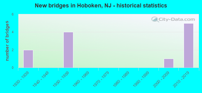
- New bridges - historical statistics
- 21930-1939
- 41950-1959
- 12000-2009
- 52010-2019

- Reconstructed bridges - Historical Statistics
- 11990-1999
- 12000-2009
- 12010-2019


- Bridge Condition - Deck
- 33.3%Good
- 16.7%Satisfactory
- 50.0%Fair

- Bridge Condition - Superstructure
- 33.3%Good
- 66.7%Satisfactory

- Bridge Condition - Substructure
- 50.0%Good
- 50.0%Satisfactory

- Bridge Condition - Channel
- 66.7%Very good
- 33.3%Good
Find on map >> Show street view
Structure Number: 900001, Location: 0.8 MILES SOUTH OF NJ 495 (Lat: 40.756800, Lng: -74.027750), Route carried "on" structure: County highway 677, Year Built: 1958, Year Reconstructed: 1999, Status: Open, Structure Length: 25.85m (84.81ft), Average Daily Traffic: 22,270 (year 2021), Truck Traffic: 3%, Average Future Daily Traffic: 26,724 (year 2041), Features Intersected: HUDS-BERG LR&HARBOR BLVD
Minimum Vertical Clearance: 30.18m (99.02ft), Kilometerpoint: 1.593, Lanes on structure: 2, Lanes under structure: 1, Owner: County Highway Agency, Approaching Roadway Width: 10.1m (33.1ft), Skew: 3 degrees, Material/Design: Steel, Design/Construction: Girder and Floorbeam System, Number Of Spans In Main Unit: 1, Number Of Approach Spans: 13, Length of Maximum Span: 41.8m (137.1ft), Curb or Sidewalk Widths: Left: 0.3m (1.0ft), Right: 1.5m (4.9ft), Curb-To-Curb Width: 10.1m (33.1ft), Out-to-Out Width: 13.4m (44.0ft)
Condition: Deck: Fair, Superstructure: Satisfactory, Substructure: Satisfactory, Operating Rating: 67.1 metric tons, Method Used To Determine Operating Rating: Load Factor (LF), Inventory Rating: 39.9 metric tons, Method Used To Determine Inventory Rating: Load Factor (LF), Structural Evaluation: Equal to present minimum criteria, Deck Geometry: Meets minimum limits, Underclear: High priority of replacement, Approach Roadway Alignment: Equal to present minimum criteria, Length Of Structure Improvement: 26.09m (85.60ft), Designated Inspection Frequency: Every 24 months, Critical Feature Inspection Frequency: Every 24 months, Inspection Date: March 2021, Critical Feature Inspection Date: March 2021, Bridge Improvement Cost: $18,126,000, Roadway Improvement Cost: $1,813,000, Total Project Cost: $28,300,000 ( Estimate for 2021), Deck Structure Type: Concrete Cast-file-Place, Wearing Surface/Protective System: Wearing Surface: Monolithic Concrete
Find on map >> Show street view
Structure Number: 900002, Location: 0.7 MILES SOUTH OF NJ 495 (Lat: 40.756869, Lng: -74.028650), Route carried "on" structure: County highway 675, Year Built: 1935, Status: Open, Structure Length: 22.28m (73.10ft), Average Daily Traffic: 15,949 (year 2021), Truck Traffic: 4%, Average Future Daily Traffic: 19,138 (year 2041), Features Intersected: HUDS-BERG LR & 18TH ST
Minimum Vertical Clearance: 30+ m (98+ ft), Kilometerpoint: 0.000, Lanes on structure: 2, Lanes under structure: 1, Owner: County Highway Agency, Approaching Roadway Width: 12.3m (40.4ft), Material/Design: Steel, Design/Construction: Girder and Floorbeam System, Number Of Spans In Main Unit: 3, Number Of Approach Spans: 19, Length of Maximum Span: 20.7m (67.9ft), Curb or Sidewalk Widths: Left: 0.7m (2.3ft), Right: 0.7m (2.3ft), Curb-To-Curb Width: 12.3m (40.4ft), Out-to-Out Width: 15.9m (52.2ft)
Condition: Deck: Fair, Superstructure: Satisfactory, Substructure: Satisfactory, Operating Rating: 37.2 metric tons, Method Used To Determine Operating Rating: Load Factor (LF), Inventory Rating: 22.7 metric tons, Method Used To Determine Inventory Rating: Load Factor (LF), Structural Evaluation: Somewhat better than minimum adequacy, Deck Geometry: Somewhat better than minimum adequacy, Underclear: High priority of replacement, Approach Roadway Alignment: Equal to present desirable criteria, Length Of Structure Improvement: 22.49m (73.79ft), Designated Inspection Frequency: Every 24 months, Critical Feature Inspection Frequency: Every 24 months, Inspection Date: March 2021, Critical Feature Inspection Date: March 2021, Bridge Improvement Cost: $15,911,000, Roadway Improvement Cost: $1,591,000, Total Project Cost: $23,950,000 ( Estimate for 2021), Deck Structure Type: Concrete Cast-file-Place, Wearing Surface/Protective System: Wearing Surface: Bituminous
Find on map >> Show street view
Structure Number: 900016, Location: AT CR 670 JCT (Lat: 40.754900, Lng: -74.035550), Route carried "on" structure: County highway 670, Year Built: 2014, Status: Open, Structure Length: 36.06m (118.31ft), Average Daily Traffic: 18,953 (year 2021), Truck Traffic: 4%, Average Future Daily Traffic: 22,743 (year 2041), Design Load: HL 93, Features Intersected: HBLTR & LOCAL STREETS, Facility Carried by Structure: 14TH ST VIADUCT
Minimum Vertical Clearance: 30+ m (98+ ft), Kilometerpoint: 0.000, Lanes on structure: 4, Lanes under structure: 6, Owner: County Highway Agency, Approaching Roadway Width: 15.8m (51.8ft), Material/Design: Steel continuous, Design/Construction: Stringer/Multi-beam, Number Of Spans In Main Unit: 8, Length of Maximum Span: 59.4m (194.9ft), Curb or Sidewalk Widths: Left: 0.0m, Right: 1.8m (5.9ft), Curb-To-Curb Width: 15.8m (51.8ft), Out-to-Out Width: 18.4m (60.4ft)
Condition: Deck: Good, Superstructure: Good, Substructure: Good, Operating Rating: 75.5 metric tons, Method Used To Determine Operating Rating: Load and Resistance Factor Rating (LRFR) rating reported by rating factor(RF) method using HL-93 loadings, Inventory Rating: 58.3 metric tons, Method Used To Determine Inventory Rating: Load and Resistance Factor Rating (LRFR) rating reported by rating factor(RF) method using HL-93 loadings, Structural Evaluation: Better than present minimum criteria, Deck Geometry: Meets minimum limits, Underclear: Superior to present desirable criteria, Approach Roadway Alignment: Equal to present desirable criteria, Designated Inspection Frequency: Every 24 months, Inspection Date: March 2021, Deck Structure Type: Concrete Cast-file-Place, Wearing Surface/Protective System: Wearing Surface: Monolithic Concrete, Deck Protection: Epoxy Coated Reinforcing
Find on map >> Show street view
Structure Number: 900036, Location: 0.08 Mi. East of CR 679 (Lat: 40.751961, Lng: -74.023411), Route carried "on" structure: City street , Year Built: 1950, Year Reconstructed: 2011, Status: Open, Structure Length: 9.42m (30.91ft), Average Daily Traffic: 2,024 (year 2021), Truck Traffic: 3%, Average Future Daily Traffic: 2,428 (year 2041), Design Load: Greater than HL93, Features Intersected: Hudson River, Facility Carried by Structure: 12th St/Sinatra Dr
Minimum Vertical Clearance: 30+ m (98+ ft), Kilometerpoint: 0.000, Lanes on structure: 2, Owner: County Highway Agency, Approaching Roadway Width: 9.1m (29.9ft), Material/Design: Concrete, Design/Construction: Slab, Number Of Spans In Main Unit: 24, Length of Maximum Span: 7.0m (23.0ft), Curb or Sidewalk Widths: Left: 0.0m, Right: 3.0m (9.8ft), Curb-To-Curb Width: 8.4m (27.6ft), Out-to-Out Width: 9.1m (29.9ft)
Condition: Deck: Good, Superstructure: Good, Substructure: Good, Channel: Very good, Operating Rating: 69.9 metric tons, Method Used To Determine Operating Rating: Load Factor (LF), Inventory Rating: 41.7 metric tons, Method Used To Determine Inventory Rating: Load Factor (LF), Structural Evaluation: Better than present minimum criteria, Deck Geometry: High priority of corrective action, Waterway Adequacy: Equal to present minimum criteria, Approach Roadway Alignment: Equal to present desirable criteria, Length Of Structure Improvement: 3.66m (12.01ft), Designated Inspection Frequency: Every 24 months, Underwater Inspection Frequency: Every 24 months, Inspection Date: March 2021, Underwater Inspection Date: June 2021, Bridge Improvement Cost: $960,000, Roadway Improvement Cost: $96,000, Total Project Cost: $1,955,000 ( Estimate for 2017), Deck Structure Type: Concrete Cast-file-Place, Wearing Surface/Protective System: Wearing Surface: Bituminous
Find on map >> Show street view
Structure Number: 900037, Location: At 14th St Intersection (Lat: 40.752461, Lng: -74.023469), Route carried "on" structure: City street , Year Built: 1950, Year Reconstructed: 2017, Status: Open, Structure Length: 5.03m (16.50ft), Average Daily Traffic: 2,024 (year 2021), Truck Traffic: 3%, Average Future Daily Traffic: 2,428 (year 2041), Design Load: HS 25 or greater, Features Intersected: Hudson River, Facility Carried by Structure: Sinatra Dr North
Minimum Vertical Clearance: 30+ m (98+ ft), Kilometerpoint: 0.000, Lanes on structure: 2, Owner: County Highway Agency, Approaching Roadway Width: 9.1m (29.9ft), Material/Design: Steel, Design/Construction: Slab, Number Of Spans In Main Unit: 7, Length of Maximum Span: 12.2m (40.0ft), Curb or Sidewalk Widths: Left: 0.0m, Right: 3.0m (9.8ft), Curb-To-Curb Width: 8.6m (28.2ft), Out-to-Out Width: 8.7m (28.5ft)
Condition: Deck: Satisfactory, Superstructure: Satisfactory, Substructure: Satisfactory, Channel: Very good, Operating Rating: 49.0 metric tons, Method Used To Determine Operating Rating: Field evaluation and documented engineering judgment, Inventory Rating: 32.7 metric tons, Method Used To Determine Inventory Rating: Field evaluation and documented engineering judgment, Structural Evaluation: Equal to present minimum criteria, Deck Geometry: Meets minimum limits, Waterway Adequacy: Equal to present desirable criteria, Approach Roadway Alignment: Equal to present desirable criteria, Length Of Structure Improvement: 8.60m (28.22ft), Designated Inspection Frequency: Every 24 months, Underwater Inspection Frequency: Every 24 months, Inspection Date: October 2021, Underwater Inspection Date: June 2021, Bridge Improvement Cost: $2,256,000, Roadway Improvement Cost: $226,000, Total Project Cost: $3,943,000 ( Estimate for 2015), Deck Structure Type: Concrete Precast Panels, Wearing Surface/Protective System: Wearing Surface: Bituminous, Deck Protection: Epoxy Coated Reinforcing
Find on map >> Show street view
Structure Number: 900038, Location: 0.06 MI EAST OF CR 679 (Lat: 40.753281, Lng: -74.023181), Route carried "on" structure: City street , Year Built: 2006, Status: Open, Structure Length: 8.90m (29.20ft), Average Daily Traffic: 530 (year 2021), Truck Traffic: 3%, Average Future Daily Traffic: 636 (year 2041), Features Intersected: Hudson River, Facility Carried by Structure: Sinatra Dr. North
Minimum Vertical Clearance: 30+ m (98+ ft), Kilometerpoint: 0.000, Lanes on structure: 2, Owner: County Highway Agency, Approaching Roadway Width: 9.1m (29.9ft), Material/Design: Concrete, Design/Construction: Slab, Number Of Spans In Main Unit: 14, Length of Maximum Span: 14.0m (45.9ft), Curb or Sidewalk Widths: Left: 3.0m (9.8ft), Right: 9.8m (32.2ft), Curb-To-Curb Width: 9.1m (29.9ft), Out-to-Out Width: 22.3m (73.2ft)
Condition: Deck: Fair, Superstructure: Satisfactory, Substructure: Good, Channel: Good, Operating Rating: 36.3 metric tons, Method Used To Determine Operating Rating: Load and Resistance Factor (LRFR), Inventory Rating: 21.8 metric tons, Method Used To Determine Inventory Rating: Load and Resistance Factor (LRFR), Structural Evaluation: Somewhat better than minimum adequacy, Deck Geometry: Equal to present minimum criteria, Waterway Adequacy: Equal to present minimum criteria, Approach Roadway Alignment: Equal to present desirable criteria, Designated Inspection Frequency: Every 24 months, Underwater Inspection Frequency: Every 24 months, Inspection Date: March 2021, Underwater Inspection Date: June 2021, Deck Structure Type: Concrete Precast Panels, Wearing Surface/Protective System: Wearing Surface: Bituminous, Deck Protection: Epoxy Coated Reinforcing
Find on map >> Show street view
Structure Number: 900001, Location: 0.8 MILES SOUTH OF NJ 495 (Lat: 40.756800, Lng: -74.027750), Route carried "under" structure: City street , Year Built: 1958, Structure Length: 0. m, Average Daily Traffic: 353 (year 2021), Truck Traffic: 1%, Features Intersected: HUDS-BERG LR&HARBOR BLVD, Facility Carried by Structure: PARK AVENUE(CR677)
Minimum Vertical Clearance: 6.71m (22.01ft), Kilometerpoint: 0.000, Lanes on structure: 2, Lanes under structure: 1, Material/Design: Steel, Design/Construction: Girder and Floorbeam System, Length of Maximum Span: 41.8m (137.1ft)
Find on map >> Show street view
Structure Number: 900002, Location: 0.7 MILES SOUTH OF NJ 495 (Lat: 40.756869, Lng: -74.028650), Route carried "under" structure: City street , Year Built: 1935, Structure Length: 0. m, Average Daily Traffic: 32 (year 2021), Features Intersected: HUDS-BERG LR & 18TH ST, Facility Carried by Structure: WILLOW AVE (CR675)
Minimum Vertical Clearance: 3.25m (10.66ft), Kilometerpoint: 0.000, Lanes on structure: 2, Lanes under structure: 1, Material/Design: Steel, Design/Construction: Girder and Floorbeam System, Length of Maximum Span: 20.7m (67.9ft)
Find on map >> Show street view
Structure Number: 900016, Location: AT CR 670 JCT (Lat: 40.754900, Lng: -74.035550), Route carried "under" structure: City street , Year Built: 2014, Structure Length: 0. m, Average Daily Traffic: 696 (year 2021), Truck Traffic: 3%, Features Intersected: HBLTR & LOCAL STREETS, Facility Carried by Structure: 14TH ST VIADUCT
Minimum Vertical Clearance: 6.04m (19.82ft), Kilometerpoint: 0.000, Lanes on structure: 4, Lanes under structure: 1, Material/Design: Steel continuous, Design/Construction: Stringer/Multi-beam, Length of Maximum Span: 59.4m (194.9ft)
Find on map >> Show street view
Structure Number: 900016, Location: AT CR 670 JCT (Lat: 40.754900, Lng: -74.035550), Route carried "under" structure: City street , Year Built: 2014, Structure Length: 0. m, Average Daily Traffic: 343 (year 2021), Truck Traffic: 3%, Features Intersected: HBLTR & LOCAL STREETS, Facility Carried by Structure: 14TH ST VIADUCT
Minimum Vertical Clearance: 14.05m (46.10ft), Kilometerpoint: 0.000, Lanes on structure: 4, Lanes under structure: 2, Material/Design: Steel continuous, Design/Construction: Stringer/Multi-beam, Length of Maximum Span: 59.4m (194.9ft)
Find on map >> Show street view
Structure Number: 900016, Location: AT CR 670 JCT (Lat: 40.754900, Lng: -74.035550), Route carried "under" structure: City street , Year Built: 2014, Structure Length: 0. m, Average Daily Traffic: 270 (year 2021), Truck Traffic: 3%, Features Intersected: HBLTR & LOCAL STREETS, Facility Carried by Structure: 14TH ST VIADUCT
Minimum Vertical Clearance: 17.65m (57.91ft), Kilometerpoint: 2.012, Lanes on structure: 4, Lanes under structure: 2, Material/Design: Steel continuous, Design/Construction: Stringer/Multi-beam, Length of Maximum Span: 59.4m (194.9ft)
Find on map >> Show street view
Structure Number: 900016, Location: AT CR 670 JCT (Lat: 40.754900, Lng: -74.035550), Route carried "under" structure: City street , Year Built: 2014, Structure Length: 0. m, Average Daily Traffic: 343 (year 2021), Truck Traffic: 3%, Features Intersected: HBLTR & LOCAL STREETS, Facility Carried by Structure: 14TH ST VIADUCT
Minimum Vertical Clearance: 9.98m (32.74ft), Kilometerpoint: 0.113, Lanes on structure: 4, Lanes under structure: 1, Material/Design: Steel continuous, Design/Construction: Stringer/Multi-beam, Length of Maximum Span: 59.4m (194.9ft)