Bridge Statistics for Hillside, Illinois (IL)
Condition, Traffic, Stress, Structural Evaluation, Project Costs
- National Bridge Inventory (NBI) Statistics
- 31Number of bridges
- 348ft / 106mTotal length
- $1,044,000Total costs
- 1,592,250Total average daily traffic
- 193,431Total average daily truck traffic
- National Bridge Inventory (NBI) Registered Bridges for Hillside
- No street view available for this location
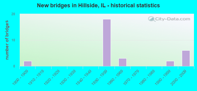
- New bridges - historical statistics
- 21900-1909
- 181950-1959
- 31960-1969
- 21990-1999
- 62000-2009

- Reconstructed bridges - Historical Statistics
- 11970-1979
- 01980-1989
- 01990-1999
- 22000-2009


- Bridge Condition - Deck
- 35.7%Good
- 64.3%Satisfactory

- Bridge Condition - Superstructure
- 7.1%Very good
- 35.7%Good
- 42.9%Satisfactory
- 14.3%Fair

- Bridge Condition - Substructure
- 14.3%Very good
- 28.6%Good
- 35.7%Satisfactory
- 21.4%Fair
Find on map >> Show street view
Structure Number: 160085, Location: 1.5 M W US 45 (Lat: 41.873192, Lng: -87.908469), Route carried "on" structure: Interstate 290, Year Built: 1953, Year Reconstructed: 2000, Status: Open, Structure Length: 9.59m (31.46ft), Average Daily Traffic: 32,700 (year 2021), Truck Traffic: 12%, Average Future Daily Traffic: 56,805 (year 2032), Design Load: HS 20+Mod, Features Intersected: I- 88 EW TOLL
Minimum Vertical Clearance: 30+ m (98+ ft), Kilometerpoint: 25.926, Lanes on structure: 2, Lanes under structure: 4, Base Highway Network: Yes, Owner: State Highway Agency, Approaching Roadway Width: 18.1m (59.4ft), Skew: 5 degrees, Material/Design: Steel continuous, Design/Construction: Stringer/Multi-beam, Number Of Spans In Main Unit: 4, Length of Maximum Span: 26.1m (85.6ft), Curb-To-Curb Width: 17.6m (57.7ft), Out-to-Out Width: 18.5m (60.7ft)
Condition: Deck: Good, Superstructure: Fair, Substructure: Good, Operating Rating: 70.3 metric tons, Method Used To Determine Operating Rating: Load Factor (LF) rating reported by rating factor (RF) method using MS18 loading, Inventory Rating: 42.1 metric tons, Method Used To Determine Inventory Rating: Load Factor (LF) rating reported by rating factor (RF) method using MS18 loading, Structural Evaluation: Somewhat better than minimum adequacy, Deck Geometry: Superior to present desirable criteria, Underclear: High priority of corrective action, Approach Roadway Alignment: Equal to present desirable criteria, Length Of Structure Improvement: 8.93m (29.30ft), Designated Inspection Frequency: Every 24 months, Inspection Date: November 2020, Bridge Improvement Cost: $633,000, Roadway Improvement Cost: $63,000, Total Project Cost: $1,044,000, Deck Structure Type: Concrete Cast-file-Place, Wearing Surface/Protective System: Deck Protection: Epoxy Coated Reinforcing
Find on map >> Show street view
Structure Number: 160086, Location: 1 M W US 45 (Lat: 41.873703, Lng: -87.902894), Route carried "on" structure: Interstate 290, Year Built: 1952, Year Reconstructed: 1984, Status: Open, Structure Length: 5.08m (16.67ft), Average Daily Traffic: 137,800 (year 2021), Truck Traffic: 8%, Average Future Daily Traffic: 213,004 (year 2032), Design Load: HS 20+Mod, Features Intersected: WOLF RD
Minimum Vertical Clearance: 30+ m (98+ ft), Kilometerpoint: 26.441, Lanes on structure: 7, Lanes under structure: 4, Base Highway Network: Yes, Owner: State Highway Agency, Approaching Roadway Width: 36.6m (120.1ft), Skew: 30 degrees, Material/Design: Steel continuous, Design/Construction: Stringer/Multi-beam, Number Of Spans In Main Unit: 3, Length of Maximum Span: 19.5m (64.0ft), Curb-To-Curb Width: 33.8m (110.9ft), Out-to-Out Width: 35.7m (117.1ft)
Condition: Deck: Satisfactory, Superstructure: Satisfactory, Substructure: Satisfactory, Operating Rating: 60.9 metric tons, Method Used To Determine Operating Rating: Load Factor (LF) rating reported by rating factor (RF) method using MS18 loading, Inventory Rating: 36.6 metric tons, Method Used To Determine Inventory Rating: Load Factor (LF) rating reported by rating factor (RF) method using MS18 loading, Structural Evaluation: Equal to present minimum criteria, Deck Geometry: Superior to present desirable criteria, Underclear: High priority of corrective action, Approach Roadway Alignment: Equal to present desirable criteria, Designated Inspection Frequency: Every 24 months, Inspection Date: August 2020, Deck Structure Type: Concrete Cast-file-Place, Wearing Surface/Protective System: Deck Protection: Epoxy Coated Reinforcing
Find on map >> Show street view
Structure Number: 160986, Location: 0.7 M W US 12 (Lat: 41.872231, Lng: -87.896794), Route carried "on" structure: Interstate 290, Year Built: 1952, Status: Open, Structure Length: 1.12m (3.67ft), Average Daily Traffic: 137,800 (year 2021), Truck Traffic: 8%, Average Future Daily Traffic: 213,004 (year 2032), Design Load: HS 20+Mod, Features Intersected: HILLSIDE DR
Minimum Vertical Clearance: 30+ m (98+ ft), Kilometerpoint: 26.972, Lanes on structure: 7, Lanes under structure: 2, Base Highway Network: Yes, Owner: State Highway Agency, Approaching Roadway Width: 25.9m (85.0ft), Skew: 30 degrees, Material/Design: Steel, Design/Construction: Stringer/Multi-beam, Number Of Spans In Main Unit: 1, Length of Maximum Span: 10.9m (35.8ft), Curb-To-Curb Width: 33.8m (110.9ft), Out-to-Out Width: 35.7m (117.1ft)
Condition: Deck: Satisfactory, Superstructure: Satisfactory, Substructure: Satisfactory, Operating Rating: 89.1 metric tons, Method Used To Determine Operating Rating: Load Factor (LF) rating reported by rating factor (RF) method using MS18 loading, Inventory Rating: 59.0 metric tons, Method Used To Determine Inventory Rating: Load Factor (LF) rating reported by rating factor (RF) method using MS18 loading, Structural Evaluation: Equal to present minimum criteria, Deck Geometry: Superior to present desirable criteria, Underclear: High priority of corrective action, Approach Roadway Alignment: Equal to present desirable criteria, Designated Inspection Frequency: Every 24 months, Inspection Date: Febuary 2021, Deck Structure Type: Concrete Cast-file-Place, Wearing Surface/Protective System: Deck Protection: Epoxy Coated Reinforcing
Find on map >> Show street view
Structure Number: 162023, Location: 1.4 M W US 12 (Lat: 41.872889, Lng: -87.909542), Route carried "on" structure: Other road , Year Built: 1952, Year Reconstructed: 2000, Status: Open, Structure Length: 8.78m (28.81ft), Average Daily Traffic: 1,150 (year 2018), Truck Traffic: 15%, Average Future Daily Traffic: 824 (year 2032), Design Load: HS 20, Features Intersected: I- 88 EW TOLL, Facility Carried by Structure: RR AVE/DARMSTADT R
Minimum Vertical Clearance: 30+ m (98+ ft), Kilometerpoint: 0.435, Lanes on structure: 2, Lanes under structure: 4, Owner: State Highway Agency, Approaching Roadway Width: 9.1m (29.9ft), Skew: 5 degrees, Material/Design: Steel continuous, Design/Construction: Stringer/Multi-beam, Number Of Spans In Main Unit: 5, Length of Maximum Span: 21.0m (68.9ft), Curb or Sidewalk Widths: Left: 0.0m, Right: 1.5m (4.9ft), Curb-To-Curb Width: 9.1m (29.9ft), Out-to-Out Width: 11.4m (37.4ft)
Condition: Deck: Good, Superstructure: Fair, Substructure: Good, Operating Rating: 80.7 metric tons, Method Used To Determine Operating Rating: Load Factor (LF) rating reported by rating factor (RF) method using MS18 loading, Inventory Rating: 40.8 metric tons, Method Used To Determine Inventory Rating: Load Factor (LF) rating reported by rating factor (RF) method using MS18 loading, Structural Evaluation: Somewhat better than minimum adequacy, Deck Geometry: Somewhat better than minimum adequacy, Underclear: High priority of corrective action, Approach Roadway Alignment: Equal to present desirable criteria, Designated Inspection Frequency: Every 24 months, Inspection Date: November 2020, Deck Structure Type: Concrete Cast-file-Place, Wearing Surface/Protective System: Deck Protection: Epoxy Coated Reinforcing
Find on map >> Show street view
Structure Number: 162684, Location: 0.5 M N ILL 38 P20 (Lat: 41.869600, Lng: -87.916425), Route carried "on" structure: Other road , Year Built: 1993, Status: Open, Structure Length: 10.82m (35.50ft), Average Daily Traffic: 22,100 (year 2020), Average Future Daily Traffic: 21,012 (year 2032), Design Load: HS 20, Features Intersected: I88, Facility Carried by Structure: I294 COLL-DISTR
Minimum Vertical Clearance: 30+ m (98+ ft), Kilometerpoint: 0.547, Lanes on structure: 2, Lanes under structure: 4, Base Highway Network: Yes (Inventory Route: 10294072, Subroute: 10), Toll: On toll road, Owner: State Toll Authority, Approaching Roadway Width: 14.4m (47.2ft), Material/Design: Steel continuous, Design/Construction: Stringer/Multi-beam, Number Of Spans In Main Unit: 3, Length of Maximum Span: 44.0m (144.4ft), Curb-To-Curb Width: 13.4m (44.0ft), Out-to-Out Width: 14.4m (47.2ft)
Condition: Deck: Satisfactory, Superstructure: Good, Substructure: Fair, Operating Rating: 56.7 metric tons, Method Used To Determine Operating Rating: Load Factor (LF) rating reported by rating factor (RF) method using MS18 loading, Inventory Rating: 34.0 metric tons, Method Used To Determine Inventory Rating: Load Factor (LF) rating reported by rating factor (RF) method using MS18 loading, Structural Evaluation: Somewhat better than minimum adequacy, Deck Geometry: Superior to present desirable criteria, Underclear: High priority of corrective action, Approach Roadway Alignment: Equal to present desirable criteria, Designated Inspection Frequency: Every 24 months, Inspection Date: May 2019, Deck Structure Type: Concrete Cast-file-Place, Wearing Surface/Protective System: Wearing Surface: Bituminous, Membrane: Built-up
Find on map >> Show street view
Structure Number: 162685, Location: .3M SO OF IL56 (Lat: 41.869103, Lng: -87.917464), Route carried "on" structure: Interstate 88, Year Built: 1960, Status: Open, Structure Length: 7.71m (25.30ft), Average Daily Traffic: 81,300 (year 2020), Truck Traffic: 15%, Average Future Daily Traffic: 114,330 (year 2032), Design Load: HS 20, Features Intersected: I294WB & IL38WB RMPS
Minimum Vertical Clearance: 30+ m (98+ ft), Kilometerpoint: 225.028, Lanes on structure: 4, Lanes under structure: 2, Base Highway Network: Yes, Toll: On toll road, Owner: State Toll Authority, Approaching Roadway Width: 11.0m (36.1ft), Material/Design: Concrete continuous, Design/Construction: Frame, Number Of Spans In Main Unit: 2, Length of Maximum Span: 28.0m (91.9ft), Curb-To-Curb Width: 11.0m (36.1ft), Out-to-Out Width: 11.0m (36.1ft)
Condition: Deck: Satisfactory, Superstructure: Satisfactory, Substructure: Satisfactory, Operating Rating: 61.6 metric tons, Method Used To Determine Operating Rating: Load Factor (LF) rating reported by rating factor (RF) method using MS18 loading, Inventory Rating: 36.9 metric tons, Method Used To Determine Inventory Rating: Load Factor (LF) rating reported by rating factor (RF) method using MS18 loading, Structural Evaluation: Equal to present minimum criteria, Deck Geometry: High priority of replacement, Underclear: High priority of corrective action, Approach Roadway Alignment: Better than present minimum criteria, Designated Inspection Frequency: Every 24 months, Inspection Date: May 2019, Deck Structure Type: Concrete Cast-file-Place, Wearing Surface/Protective System: Wearing Surface: Bituminous, Membrane: Built-up
Find on map >> Show street view
Structure Number: 162758, Location: 1 M W US 45 (Lat: 41.873406, Lng: -87.903497), Route carried "on" structure: Other road , Year Built: 2001, Status: Open, Structure Length: 5.12m (16.80ft), Average Daily Traffic: 27,000 (year 2021), Truck Traffic: 15%, Average Future Daily Traffic: 61,079 (year 2032), Design Load: HS 20+Mod, Features Intersected: WOLF RD, Facility Carried by Structure: I-290 EB IKE CD
Minimum Vertical Clearance: 30+ m (98+ ft), Kilometerpoint: 0.064, Lanes on structure: 2, Lanes under structure: 2, Base Highway Network: Yes (Inventory Route: 10290070, Subroute: 20), Owner: State Highway Agency, Approaching Roadway Width: 14.9m (48.9ft), Material/Design: Steel continuous, Design/Construction: Stringer/Multi-beam, Number Of Spans In Main Unit: 3, Length of Maximum Span: 19.6m (64.3ft), Curb-To-Curb Width: 14.9m (48.9ft), Out-to-Out Width: 15.9m (52.2ft)
Condition: Deck: Good, Superstructure: Good, Substructure: Good, Operating Rating: 89.1 metric tons, Method Used To Determine Operating Rating: Load Factor (LF) rating reported by rating factor (RF) method using MS18 loading, Inventory Rating: 68.7 metric tons, Method Used To Determine Inventory Rating: Load Factor (LF) rating reported by rating factor (RF) method using MS18 loading, Structural Evaluation: Better than present minimum criteria, Deck Geometry: Superior to present desirable criteria, Underclear: High priority of corrective action, Approach Roadway Alignment: Equal to present desirable criteria, Designated Inspection Frequency: Every 24 months, Inspection Date: October 2021, Deck Structure Type: Concrete Cast-file-Place, Wearing Surface/Protective System: Deck Protection: Epoxy Coated Reinforcing
Find on map >> Show street view
Structure Number: 162759, Location: 0.7 M W US 12 (Lat: 41.872483, Lng: -87.898019), Route carried "on" structure: Other road , Year Built: 2002, Status: Open, Structure Length: 2.61m (8.56ft), Average Daily Traffic: 27,000 (year 2021), Truck Traffic: 15%, Average Future Daily Traffic: 61,079 (year 2032), Design Load: HS 20+Mod, Features Intersected: HILLSIDE DR, Facility Carried by Structure: I-290 EB IKE CD
Minimum Vertical Clearance: 30+ m (98+ ft), Kilometerpoint: 0.595, Lanes on structure: 2, Lanes under structure: 2, Base Highway Network: Yes (Inventory Route: 10290070, Subroute: 20), Owner: State Highway Agency, Approaching Roadway Width: 12.0m (39.4ft), Material/Design: Steel, Design/Construction: Stringer/Multi-beam, Number Of Spans In Main Unit: 1, Length of Maximum Span: 26.1m (85.6ft), Curb-To-Curb Width: 12.0m (39.4ft), Out-to-Out Width: 13.0m (42.7ft)
Condition: Deck: Good, Superstructure: Very good, Substructure: Very good, Operating Rating: 89.1 metric tons, Method Used To Determine Operating Rating: Load Factor (LF) rating reported by rating factor (RF) method using MS18 loading, Inventory Rating: 73.9 metric tons, Method Used To Determine Inventory Rating: Load Factor (LF) rating reported by rating factor (RF) method using MS18 loading, Structural Evaluation: Equal to present desirable criteria, Deck Geometry: Equal to present minimum criteria, Underclear: Superior to present desirable criteria, Approach Roadway Alignment: Equal to present desirable criteria, Designated Inspection Frequency: Every 24 months, Inspection Date: March 2020, Deck Structure Type: Concrete Cast-file-Place, Wearing Surface/Protective System: Deck Protection: Epoxy Coated Reinforcing
Find on map >> Show street view
Structure Number: 16276, Location: 0.5 M N IL 38 (Lat: 41.870878, Lng: -87.882972), Route carried "on" structure: US 12, Year Built: 2000, Status: Open, Structure Length: 9.14m (29.99ft), Average Daily Traffic: 32,800 (year 2021), Truck Traffic: 9%, Average Future Daily Traffic: 39,037 (year 2032), Features Intersected: I-290 IKE
Minimum Vertical Clearance: 30+ m (98+ ft), Kilometerpoint: 89.171, Lanes on structure: 6, Lanes under structure: 7, Base Highway Network: Yes, Owner: State Highway Agency, Approaching Roadway Width: 32.5m (106.6ft), Skew: 30 degrees, Material/Design: Steel continuous, Design/Construction: Stringer/Multi-beam, Number Of Spans In Main Unit: 3, Number Of Approach Spans: 2, Length of Maximum Span: 26.8m (87.9ft), Curb or Sidewalk Widths: Left: 1.5m (4.9ft), Right: 1.5m (4.9ft), Curb-To-Curb Width: 30.0m (98.4ft), Out-to-Out Width: 38.6m (126.6ft)
Condition: Deck: Good, Superstructure: Good, Substructure: Very good, Operating Rating: 65.8 metric tons, Method Used To Determine Operating Rating: Load Factor (LF) rating reported by rating factor (RF) method using MS18 loading, Inventory Rating: 40.8 metric tons, Method Used To Determine Inventory Rating: Load Factor (LF) rating reported by rating factor (RF) method using MS18 loading, Structural Evaluation: Better than present minimum criteria, Deck Geometry: Superior to present desirable criteria, Underclear: High priority of corrective action, Approach Roadway Alignment: Equal to present desirable criteria, Designated Inspection Frequency: Every 24 months, Other Special Inspection Frequency: Every 72 months, Inspection Date: August 2020, Other Special Inspection Date: September 2016, Deck Structure Type: Concrete Cast-file-Place, Wearing Surface/Protective System: Deck Protection: Epoxy Coated Reinforcing
Find on map >> Show street view
Structure Number: 169803, Location: I294 & ILL 56 P20 (Lat: 41.873475, Lng: -87.918231), Route carried "on" structure: Interstate 294, Year Built: 1958, Status: Open, Structure Length: 2.59m (8.50ft), Average Daily Traffic: 65,850 (year 2020), Truck Traffic: 15%, Average Future Daily Traffic: 69,886 (year 2032), Features Intersected: BUTTERFIELD R ILL 56
Minimum Vertical Clearance: 30+ m (98+ ft), Kilometerpoint: 34.745, Lanes on structure: 3, Lanes under structure: 2, Base Highway Network: Yes, Toll: On toll road, Owner: State Toll Authority, Approaching Roadway Width: 15.8m (51.8ft), Material/Design: Prestressed concrete, Design/Construction: Stringer/Multi-beam, Number Of Spans In Main Unit: 1, Length of Maximum Span: 24.4m (80.1ft), Curb-To-Curb Width: 16.5m (54.1ft), Out-to-Out Width: 21.0m (68.9ft)
Condition: Deck: Satisfactory, Superstructure: Satisfactory, Substructure: Satisfactory, Operating Rating: 97.2 metric tons, Method Used To Determine Operating Rating: Load Factor (LF) rating reported by rating factor (RF) method using MS18 loading, Inventory Rating: 59.6 metric tons, Method Used To Determine Inventory Rating: Load Factor (LF) rating reported by rating factor (RF) method using MS18 loading, Structural Evaluation: Equal to present minimum criteria, Deck Geometry: Equal to present minimum criteria, Underclear: Equal to present minimum criteria, Approach Roadway Alignment: Equal to present desirable criteria, Designated Inspection Frequency: Every 24 months, Inspection Date: April 2021, Deck Structure Type: Concrete Cast-file-Place, Wearing Surface/Protective System: Wearing Surface: Bituminous, Membrane: Built-up
Find on map >> Show street view
Structure Number: 169804, Location: 0.5 M N ILL 38 P20 (Lat: 41.869197, Lng: -87.917231), Route carried "on" structure: Interstate 294, Year Built: 1958, Status: Open, Structure Length: 14.20m (46.59ft), Average Daily Traffic: 65,850 (year 2020), Truck Traffic: 15%, Average Future Daily Traffic: 69,886 (year 2032), Features Intersected: IS 88 (E-W TOLL)
Minimum Vertical Clearance: 30+ m (98+ ft), Kilometerpoint: 35.131, Lanes on structure: 3, Lanes under structure: 4, Base Highway Network: Yes, Toll: On toll road, Owner: State Toll Authority, Approaching Roadway Width: 15.8m (51.8ft), Skew: 2 degrees, Material/Design: Steel, Design/Construction: Stringer/Multi-beam, Number Of Spans In Main Unit: 6, Length of Maximum Span: 24.4m (80.1ft), Curb-To-Curb Width: 14.2m (46.6ft), Out-to-Out Width: 15.5m (50.9ft)
Condition: Deck: Satisfactory, Superstructure: Good, Substructure: Satisfactory, Operating Rating: 63.2 metric tons, Method Used To Determine Operating Rating: Load Factor (LF) rating reported by rating factor (RF) method using MS18 loading, Inventory Rating: 37.9 metric tons, Method Used To Determine Inventory Rating: Load Factor (LF) rating reported by rating factor (RF) method using MS18 loading, Structural Evaluation: Equal to present minimum criteria, Deck Geometry: Meets minimum limits, Underclear: Equal to present minimum criteria, Approach Roadway Alignment: Equal to present desirable criteria, Designated Inspection Frequency: Every 24 months, Inspection Date: May 2019, Deck Structure Type: Concrete Cast-file-Place, Wearing Surface/Protective System: Wearing Surface: Bituminous, Membrane: Built-up
Find on map >> Show street view
Structure Number: 169805, Location: 0.5 M N ILL 38 P20 (Lat: 41.869061, Lng: -87.917197), Route carried "on" structure: Interstate 294, Year Built: 1958, Status: Open, Structure Length: 14.20m (46.59ft), Average Daily Traffic: 57,700 (year 2020), Truck Traffic: 22%, Average Future Daily Traffic: 62,933 (year 2032), Features Intersected: IS 88 (E-W TOLL)
Minimum Vertical Clearance: 30+ m (98+ ft), Kilometerpoint: 35.147, Lanes on structure: 3, Lanes under structure: 4, Base Highway Network: Yes, Toll: On toll road, Owner: State Toll Authority, Approaching Roadway Width: 15.8m (51.8ft), Skew: 2 degrees, Material/Design: Steel, Number Of Spans In Main Unit: 6, Length of Maximum Span: 24.4m (80.1ft), Curb-To-Curb Width: 14.2m (46.6ft), Out-to-Out Width: 15.5m (50.9ft)
Condition: Deck: Satisfactory, Superstructure: Good, Substructure: Good, Operating Rating: 64.5 metric tons, Method Used To Determine Operating Rating: Load Factor (LF) rating reported by rating factor (RF) method using MS18 loading, Inventory Rating: 38.6 metric tons, Method Used To Determine Inventory Rating: Load Factor (LF) rating reported by rating factor (RF) method using MS18 loading, Structural Evaluation: Better than present minimum criteria, Deck Geometry: Meets minimum limits, Underclear: High priority of corrective action, Approach Roadway Alignment: Equal to present desirable criteria, Designated Inspection Frequency: Every 24 months, Inspection Date: May 2019, Deck Structure Type: Concrete Cast-file-Place, Wearing Surface/Protective System: Wearing Surface: Bituminous, Membrane: Built-up
Find on map >> Show street view
Structure Number: 169996, Location: 0.2 M N ILL 38 P20 (Lat: 41.864725, Lng: -87.917767), Route carried "on" structure: Interstate 294, Year Built: 1958, Status: Open, Structure Length: 7.56m (24.80ft), Average Daily Traffic: 57,700 (year 2020), Truck Traffic: 22%, Average Future Daily Traffic: 62,933 (year 2032), Design Load: HS 20, Features Intersected: EB IL-38 TO EB.I-290
Minimum Vertical Clearance: 30+ m (98+ ft), Kilometerpoint: 35.823, Lanes on structure: 3, Lanes under structure: 2, Base Highway Network: Yes, Toll: On toll road, Owner: State Toll Authority, Approaching Roadway Width: 15.8m (51.8ft), Skew: 5 degrees, Material/Design: Steel, Design/Construction: Stringer/Multi-beam, Number Of Spans In Main Unit: 3, Length of Maximum Span: 36.3m (119.1ft), Curb-To-Curb Width: 14.2m (46.6ft), Out-to-Out Width: 18.6m (61.0ft)
Condition: Deck: Satisfactory, Superstructure: Satisfactory, Substructure: Fair, Operating Rating: 86.5 metric tons, Method Used To Determine Operating Rating: Load Factor (LF) rating reported by rating factor (RF) method using MS18 loading, Inventory Rating: 51.8 metric tons, Method Used To Determine Inventory Rating: Load Factor (LF) rating reported by rating factor (RF) method using MS18 loading, Structural Evaluation: Somewhat better than minimum adequacy, Deck Geometry: Meets minimum limits, Underclear: High priority of corrective action, Approach Roadway Alignment: Better than present minimum criteria, Designated Inspection Frequency: Every 24 months, Inspection Date: May 2020, Deck Structure Type: Concrete Cast-file-Place, Wearing Surface/Protective System: Wearing Surface: Bituminous, Membrane: Built-up
Find on map >> Show street view
Structure Number: 169997, Location: 0.2 M N ILL 38 P20 (Lat: 41.864556, Lng: -87.917822), Route carried "on" structure: Interstate 294, Year Built: 1958, Status: Open, Structure Length: 7.56m (24.80ft), Average Daily Traffic: 57,700 (year 2020), Truck Traffic: 22%, Average Future Daily Traffic: 62,933 (year 2032), Design Load: HS 20, Features Intersected: EB IL-38 TO EB I-290
Minimum Vertical Clearance: 30+ m (98+ ft), Kilometerpoint: 35.839, Lanes on structure: 3, Lanes under structure: 2, Base Highway Network: Yes, Toll: On toll road, Owner: State Toll Authority, Approaching Roadway Width: 19.5m (64.0ft), Skew: 5 degrees, Material/Design: Steel, Design/Construction: Stringer/Multi-beam, Number Of Spans In Main Unit: 3, Length of Maximum Span: 36.3m (119.1ft), Curb-To-Curb Width: 16.5m (54.1ft), Out-to-Out Width: 20.7m (67.9ft)
Condition: Deck: Satisfactory, Superstructure: Satisfactory, Substructure: Fair, Operating Rating: 87.8 metric tons, Method Used To Determine Operating Rating: Load Factor (LF) rating reported by rating factor (RF) method using MS18 loading, Inventory Rating: 52.5 metric tons, Method Used To Determine Inventory Rating: Load Factor (LF) rating reported by rating factor (RF) method using MS18 loading, Structural Evaluation: Somewhat better than minimum adequacy, Deck Geometry: Equal to present minimum criteria, Underclear: High priority of corrective action, Approach Roadway Alignment: Better than present minimum criteria, Designated Inspection Frequency: Every 24 months, Inspection Date: May 2020, Deck Structure Type: Concrete Cast-file-Place, Wearing Surface/Protective System: Wearing Surface: Bituminous, Membrane: Built-up
Find on map >> Show street view
Structure Number: 160085, Location: 1.5 M W US 45 (Lat: 41.873192, Lng: -87.908469), Route carried "under" structure: Interstate 88, Year Built: 1953, Structure Length: 0. m, Average Daily Traffic: 81,300 (year 2020), Truck Traffic: 15%, Features Intersected: I- 88 EW TOLL, Facility Carried by Structure: I-290 EB
Minimum Vertical Clearance: 4.60m (15.09ft), Kilometerpoint: 225.881, Lanes on structure: 2, Lanes under structure: 4, Material/Design: Steel continuous, Design/Construction: Stringer/Multi-beam, Length of Maximum Span: 26.1m (85.6ft)
Find on map >> Show street view
Structure Number: 160086, Location: 1 M W US 45 (Lat: 41.873678, Lng: -87.902539), Route carried "under" structure: Other road , Year Built: 1952, Structure Length: 0. m, Average Daily Traffic: 11,700 (year 2021), Truck Traffic: 5%, Features Intersected: WOLF RD, Facility Carried by Structure: I-290 IKE
Minimum Vertical Clearance: 4.57m (14.99ft), Kilometerpoint: 1.738, Lanes on structure: 7, Lanes under structure: 4, Material/Design: Steel continuous, Design/Construction: Stringer/Multi-beam, Length of Maximum Span: 19.5m (64.0ft)
Find on map >> Show street view
Structure Number: 160683, Location: 0.3 M N ILL 56 P20 (Lat: 41.881803, Lng: -87.903314), Route carried "under" structure: Other road , Year Built: 1900, Structure Length: 0. m, Average Daily Traffic: 8,550 (year 2021), Truck Traffic: 4%, Features Intersected: WOLF RD, Facility Carried by Structure: C&NW RR (ABANDONED
Minimum Vertical Clearance: 4.17m (13.68ft), Kilometerpoint: 0.837, Lanes under structure: 2, Material/Design: Steel, Length of Maximum Span: 15.2m (49.9ft)
Find on map >> Show street view
Structure Number: 160684, Location: 0.29 M N ILL 56 P20 (Lat: 41.881494, Lng: -87.903311), Route carried "under" structure: Other road , Year Built: 1900, Structure Length: 0. m, Average Daily Traffic: 8,550 (year 2021), Truck Traffic: 4%, Features Intersected: WOLF RD, Facility Carried by Structure: CAZE RR (ABANDONED
Minimum Vertical Clearance: 4.11m (13.48ft), Kilometerpoint: 0.869, Lanes under structure: 2, Material/Design: Steel, Design/Construction: Stringer/Multi-beam, Length of Maximum Span: 14.0m (45.9ft)
Find on map >> Show street view
Structure Number: 160986, Location: 0.7 M W US 12 (Lat: 41.872153, Lng: -87.896628), Route carried "under" structure: City street , Year Built: 1952, Structure Length: 0. m, Average Daily Traffic: 3,500 (year 2018), Truck Traffic: 5%, Features Intersected: HILLSIDE DR, Facility Carried by Structure: I-290 IKE
Minimum Vertical Clearance: 4.60m (15.09ft), Kilometerpoint: 0.064, Lanes on structure: 7, Lanes under structure: 2, Material/Design: Steel, Design/Construction: Stringer/Multi-beam, Length of Maximum Span: 10.9m (35.8ft)
Find on map >> Show street view
Structure Number: 162023, Location: 1.4 M W US 12 (Lat: 41.872889, Lng: -87.909542), Route carried "under" structure: Interstate 88, Year Built: 1952, Structure Length: 0. m, Average Daily Traffic: 81,300 (year 2020), Truck Traffic: 15%, Features Intersected: I- 88 EW TOLL, Facility Carried by Structure: RR AVE/DARMSTADT R
Minimum Vertical Clearance: 4.75m (15.58ft), Kilometerpoint: 225.688, Lanes on structure: 2, Lanes under structure: 4, Material/Design: Steel continuous, Design/Construction: Stringer/Multi-beam, Length of Maximum Span: 21.0m (68.9ft)
Find on map >> Show street view
Structure Number: 162024, Location: 0.3 M S I-290 (Lat: 41.865369, Lng: -87.882689), Route carried "under" structure: US 12, Year Built: 1967, Structure Length: 0. m, Average Daily Traffic: 32,800 (year 2021), Truck Traffic: 9%, Features Intersected: US 12,20,45 MANNHEIM, Facility Carried by Structure: RR - CN
Minimum Vertical Clearance: 4.52m (14.83ft), Kilometerpoint: 89.783, Lanes under structure: 6, Material/Design: Steel, Design/Construction: Girder and Floorbeam System, Length of Maximum Span: 18.9m (62.0ft)
Find on map >> Show street view
Structure Number: 162084, Location: 1.4 M W US 12 P20 (Lat: 41.873136, Lng: -87.908697), Route carried "under" structure: Interstate 88, Year Built: 1952, Structure Length: 0. m, Average Daily Traffic: 81,300 (year 2020), Truck Traffic: 15%, Features Intersected: I-88 E-W TOLL, Facility Carried by Structure: CC RR
Minimum Vertical Clearance: 4.50m (14.76ft), Kilometerpoint: 225.849, Lanes under structure: 4, Material/Design: Steel continuous, Design/Construction: Girder and Floorbeam System, Length of Maximum Span: 19.5m (64.0ft)
Find on map >> Show street view
Structure Number: 162684, Location: 0.5 M N ILL 38 P20 (Lat: 41.869600, Lng: -87.916425), Route carried "under" structure: Interstate 88, Year Built: 1993, Structure Length: 0. m, Average Daily Traffic: 81,300 (year 2020), Truck Traffic: 15%, Features Intersected: I88, Facility Carried by Structure: I294 COLL-DISTR
Minimum Vertical Clearance: 4.50m (14.76ft), Kilometerpoint: 225.125, Lanes on structure: 2, Lanes under structure: 4, Toll: On toll road, Material/Design: Steel continuous, Design/Construction: Stringer/Multi-beam, Length of Maximum Span: 44.0m (144.4ft)
Find on map >> Show street view
Structure Number: 162685, Location: .3M SO OF IL56 (Lat: 41.869267, Lng: -87.917092), Route carried "under" structure: Other road , Year Built: 1960, Structure Length: 0. m, Average Daily Traffic: 34,000 (year 2018), Features Intersected: I294WB & IL38WB RMPS, Facility Carried by Structure: I-88
Minimum Vertical Clearance: 4.62m (15.16ft), Kilometerpoint: 0.467, Lanes on structure: 4, Lanes under structure: 2, Toll: On toll road, Material/Design: Concrete continuous, Design/Construction: Frame, Length of Maximum Span: 28.0m (91.9ft)
Find on map >> Show street view
Structure Number: 162758, Location: 1 M W US 45 (Lat: 41.873383, Lng: -87.902522), Route carried "under" structure: Other road , Year Built: 2001, Structure Length: 0. m, Average Daily Traffic: 11,700 (year 2021), Truck Traffic: 5%, Features Intersected: WOLF RD, Facility Carried by Structure: I-290 EB IKE CD
Minimum Vertical Clearance: 5.13m (16.83ft), Kilometerpoint: 1.786, Lanes on structure: 2, Lanes under structure: 2, Material/Design: Steel continuous, Design/Construction: Stringer/Multi-beam, Length of Maximum Span: 19.6m (64.3ft)
Find on map >> Show street view
Structure Number: 162759, Location: 0.7 M W US 12 (Lat: 41.872039, Lng: -87.896717), Route carried "under" structure: City street , Year Built: 2002, Structure Length: 0. m, Average Daily Traffic: 3,500 (year 2018), Truck Traffic: 5%, Features Intersected: HILLSIDE DR, Facility Carried by Structure: I-290 EB IKE CD
Minimum Vertical Clearance: 4.55m (14.93ft), Kilometerpoint: 0.113, Lanes on structure: 2, Lanes under structure: 2, Material/Design: Steel, Design/Construction: Stringer/Multi-beam, Length of Maximum Span: 26.1m (85.6ft)
Find on map >> Show street view
Structure Number: 16276, Location: 0.5 M N IL 38 (Lat: 41.869744, Lng: -87.883022), Route carried "under" structure: Interstate 290, Year Built: 2000, Structure Length: 0. m, Average Daily Traffic: 131,300 (year 2021), Truck Traffic: 6%, Features Intersected: I-290 IKE, Facility Carried by Structure: US 12,20,45 MANNHE
Minimum Vertical Clearance: 4.45m (14.60ft), Kilometerpoint: 28.195, Lanes on structure: 6, Lanes under structure: 7, Material/Design: Steel continuous, Design/Construction: Stringer/Multi-beam, Length of Maximum Span: 26.8m (87.9ft)
Find on map >> Show street view
Structure Number: 169804, Location: 0.5 M N ILL 38 P20 (Lat: 41.869464, Lng: -87.916700), Route carried "under" structure: Interstate 88, Year Built: 1958, Structure Length: 0. m, Average Daily Traffic: 81,300 (year 2020), Truck Traffic: 15%, Features Intersected: IS 88 (E-W TOLL), Facility Carried by Structure: I-294 NB
Minimum Vertical Clearance: 4.65m (15.26ft), Kilometerpoint: 225.109, Lanes on structure: 3, Lanes under structure: 4, Toll: On toll road, Material/Design: Steel, Design/Construction: Stringer/Multi-beam, Length of Maximum Span: 24.4m (80.1ft)
Find on map >> Show street view
Structure Number: 169805, Location: 0.5 M N ILL 38 P20 (Lat: 41.869267, Lng: -87.917092), Route carried "under" structure: Interstate 88, Year Built: 1958, Structure Length: 0. m, Average Daily Traffic: 81,300 (year 2020), Truck Traffic: 15%, Features Intersected: IS 88 (E-W TOLL), Facility Carried by Structure: I-294 SB
Minimum Vertical Clearance: 4.65m (15.26ft), Kilometerpoint: 225.077, Lanes on structure: 3, Lanes under structure: 4, Toll: On toll road, Material/Design: Steel, Length of Maximum Span: 24.4m (80.1ft)
Find on map >> Show street view
Structure Number: 169996, Location: 0.2 M N ILL 38 P20 (Lat: 41.864556, Lng: -87.917822), Route carried "under" structure: Other road , Year Built: 1958, Structure Length: 0. m, Average Daily Traffic: 27,200 (year 2020), Features Intersected: EB IL-38 TO EB.I-290, Facility Carried by Structure: I-294 NB
Minimum Vertical Clearance: 4.50m (14.76ft), Kilometerpoint: 0.322, Lanes on structure: 3, Lanes under structure: 2, Toll: On toll road, Material/Design: Steel, Design/Construction: Stringer/Multi-beam, Length of Maximum Span: 36.3m (119.1ft)
Find on map >> Show street view
Structure Number: 169997, Location: 0.2 M N ILL 38 P20 (Lat: 41.864522, Lng: -87.917875), Route carried "under" structure: Other road , Year Built: 1958, Structure Length: 0. m, Average Daily Traffic: 27,200 (year 2020), Features Intersected: EB IL-38 TO EB I-290, Facility Carried by Structure: I-294 SB
Minimum Vertical Clearance: 4.72m (15.49ft), Kilometerpoint: 0.290, Lanes on structure: 3, Lanes under structure: 2, Toll: On toll road, Material/Design: Steel, Design/Construction: Stringer/Multi-beam, Length of Maximum Span: 36.3m (119.1ft)