Bridge Statistics for Highlands Ranch, Colorado (CO)
Condition, Traffic, Stress, Structural Evaluation, Project Costs
- National Bridge Inventory (NBI) Statistics
- 27Number of bridges
- 289ft / 87.8mTotal length
- $1,089,000Total costs
- 916,302Total average daily traffic
- 31,542Total average daily truck traffic
- National Bridge Inventory (NBI) Registered Bridges for Highlands Ranch
- No street view available for this location
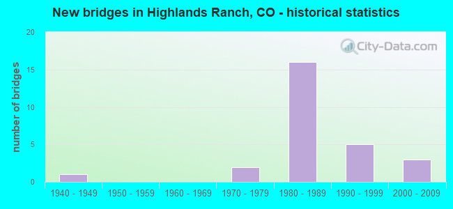
- New bridges - historical statistics
- 11940-1949
- 21970-1979
- 161980-1989
- 51990-1999
- 32000-2009

- Reconstructed bridges - Historical Statistics
- 11970-1979
- 01980-1989
- 11990-1999
- 12000-2009
- 42010-2019
- 12020-2022


- Bridge Condition - Deck
- 14.3%Very good
- 64.3%Good
- 21.4%Satisfactory

- Bridge Condition - Superstructure
- 14.3%Very good
- 42.9%Good
- 42.9%Satisfactory

- Bridge Condition - Substructure
- 92.9%Good
- 7.1%Satisfactory

- Bridge Condition - Channel
- 50.0%Very good
- 30.0%Good
- 10.0%Satisfactory
- 10.0%Fair

- Bridge Condition - Culverts
- 33.3%Good
- 50.0%Satisfactory
- 16.7%Fair
Find on map >> Show street view
Structure Number: DOU003-06.40A, Location: 1.8 MI NORTH OF TITAN RD (Lat: 39.529222, Lng: -105.054572), Route carried "on" structure: County highway , Year Built: 1993, Year Reconstructed: 2020, Status: Open, Structure Length: 0.69m (2.26ft), Average Daily Traffic: 1,046 (year 2021), Truck Traffic: 2%, Average Future Daily Traffic: 1,401 (year 2041), Design Load: HS 20, Features Intersected: HIGHLINE CANAL, Facility Carried by Structure: ROXBOROUGH PARK RD
Minimum Vertical Clearance: 30+ m (98+ ft), Kilometerpoint: 9.720, Lanes on structure: 2, Owner: County Highway Agency, Approaching Roadway Width: 11.6m (38.1ft), Material/Design: Concrete, Design/Construction: Frame, Number Of Spans In Main Unit: 1, Length of Maximum Span: 6.1m (20.0ft), Curb or Sidewalk Widths: Left: 3.6m (11.8ft), Right: 0.0m, Curb-To-Curb Width: 11.6m (38.1ft), Out-to-Out Width: 18.3m (60.0ft)
Condition: Deck: Satisfactory, Superstructure: Satisfactory, Substructure: Good, Channel: Very good, Operating Rating: 86.0 metric tons, Method Used To Determine Operating Rating: Load Factor (LF), Inventory Rating: 51.5 metric tons, Method Used To Determine Inventory Rating: Load Factor (LF), Structural Evaluation: Equal to present minimum criteria, Deck Geometry: Equal to present minimum criteria, Waterway Adequacy: Equal to present desirable criteria, Approach Roadway Alignment: Equal to present desirable criteria, Designated Inspection Frequency: Every 24 months, Inspection Date: January 2021, Deck Structure Type: Concrete Cast-file-Place, Wearing Surface/Protective System: Wearing Surface: Bituminous, Membrane: Built-up, Deck Protection: Epoxy Coated Reinforcing
Find on map >> Show street view
Structure Number: DOU004-00.1, Location: 0.5 MILES SOUTH OF C-470 (Lat: 39.557361, Lng: -104.988922), Route carried "on" structure: County highway , Year Built: 1985, Status: Open, Structure Length: 0.81m (2.66ft), Average Daily Traffic: 35,365 (year 2020), Truck Traffic: 6%, Average Future Daily Traffic: 47,389 (year 2040), Design Load: HS 20+Mod, Features Intersected: UNNAMED DRAW, Facility Carried by Structure: BROADWAY
Minimum Vertical Clearance: 30+ m (98+ ft), Kilometerpoint: 3.996, Lanes on structure: 6, Owner: County Highway Agency, Approaching Roadway Width: 30.2m (99.1ft), Skew: 2 degrees, Material/Design: Aluminum, Iron, Design/Construction: Culvert, Number Of Spans In Main Unit: 2, Length of Maximum Span: 3.4m (11.2ft), Curb or Sidewalk Widths: Left: 3.0m (9.8ft), Right: 3.0m (9.8ft), Out-to-Out Width: 92.0m (301.8ft)
Condition: Channel: Good, Culverts: Satisfactory, Structural Evaluation: Equal to present minimum criteria, Waterway Adequacy: Equal to present desirable criteria, Approach Roadway Alignment: Equal to present desirable criteria, Designated Inspection Frequency: Every 24 months, Inspection Date: January 2021
Find on map >> Show street view
Structure Number: DOU007-05.24A, Location: 0.3 MI WEST OF SANTA FE (Lat: 39.507267, Lng: -105.024364), Route carried "on" structure: County highway , Year Built: 1996, Status: Open, Structure Length: 7.74m (25.39ft), Average Daily Traffic: 19,747 (year 2022), Truck Traffic: 9%, Average Future Daily Traffic: 26,461 (year 2042), Design Load: HS 20, Features Intersected: PLUM CREEK, Facility Carried by Structure: TITAN ROAD
Minimum Vertical Clearance: 30+ m (98+ ft), Kilometerpoint: 4.128, Lanes on structure: 5, Owner: County Highway Agency, Approaching Roadway Width: 24.4m (80.1ft), Material/Design: Prestressed concrete, Design/Construction: Tee Beam, Number Of Spans In Main Unit: 4, Length of Maximum Span: 18.7m (61.4ft), Curb-To-Curb Width: 24.4m (80.1ft), Out-to-Out Width: 25.1m (82.3ft)
Condition: Deck: Good, Superstructure: Satisfactory, Substructure: Good, Channel: Very good, Operating Rating: 68.3 metric tons, Method Used To Determine Operating Rating: Load Factor (LF), Inventory Rating: 41.0 metric tons, Method Used To Determine Inventory Rating: Load Factor (LF), Structural Evaluation: Equal to present minimum criteria, Deck Geometry: Superior to present desirable criteria, Waterway Adequacy: Equal to present desirable criteria, Approach Roadway Alignment: Equal to present desirable criteria, Designated Inspection Frequency: Every 24 months, Inspection Date: January 2021, Deck Structure Type: Concrete Cast-file-Place, Wearing Surface/Protective System: Wearing Surface: Bituminous, Membrane: Built-up, Deck Protection: Epoxy Coated Reinforcing
Find on map >> Show street view
Structure Number: DOU007-05.55, Location: 0.1 MI WEST OF SANTA FE (Lat: 39.508661, Lng: -105.019414), Route carried "on" structure: County highway , Year Built: 2002, Status: Open, Structure Length: 8.13m (26.67ft), Average Daily Traffic: 18,542 (year 2021), Truck Traffic: 6%, Average Future Daily Traffic: 24,846 (year 2041), Design Load: HS 25 or greater, Features Intersected: RAILROAD, Facility Carried by Structure: TITAN ROAD
Minimum Vertical Clearance: 30+ m (98+ ft), Kilometerpoint: 0.206, Lanes on structure: 4, Owner: County Highway Agency, Approaching Roadway Width: 24.4m (80.1ft), Skew: 2 degrees, Material/Design: Prestressed concrete continuous, Design/Construction: Stringer/Multi-beam, Number Of Spans In Main Unit: 3, Length of Maximum Span: 34.9m (114.5ft), Curb-To-Curb Width: 24.4m (80.1ft), Out-to-Out Width: 25.3m (83.0ft)
Condition: Deck: Very good, Superstructure: Satisfactory, Substructure: Good, Operating Rating: 66.9 metric tons, Method Used To Determine Operating Rating: Load Factor (LF), Inventory Rating: 40.1 metric tons, Method Used To Determine Inventory Rating: Load Factor (LF), Structural Evaluation: Equal to present minimum criteria, Deck Geometry: Superior to present desirable criteria, Underclear: Better than present minimum criteria, Approach Roadway Alignment: Equal to present desirable criteria, Designated Inspection Frequency: Every 24 months, Inspection Date: January 2021, Deck Structure Type: Concrete Cast-file-Place, Wearing Surface/Protective System: Wearing Surface: Bituminous, Membrane: Built-up, Deck Protection: Epoxy Coated Reinforcing
Find on map >> Show street view
Structure Number: DOU007-05.95, Location: JUST WEST OF SANTA FE (Lat: 39.509517, Lng: -105.018042), Route carried "on" structure: County highway , Year Built: 2002, Status: Open, Structure Length: 6.35m (20.83ft), Average Daily Traffic: 18,542 (year 2021), Truck Traffic: 6%, Average Future Daily Traffic: 24,846 (year 2041), Design Load: HS 25 or greater, Features Intersected: RAILROAD, Facility Carried by Structure: TITAN ROAD
Minimum Vertical Clearance: 30+ m (98+ ft), Kilometerpoint: 0.392, Lanes on structure: 4, Owner: County Highway Agency, Approaching Roadway Width: 24.3m (79.7ft), Material/Design: Prestressed concrete continuous, Design/Construction: Stringer/Multi-beam, Number Of Spans In Main Unit: 2, Length of Maximum Span: 35.2m (115.5ft), Curb-To-Curb Width: 24.3m (79.7ft), Out-to-Out Width: 25.2m (82.7ft)
Condition: Deck: Very good, Superstructure: Satisfactory, Substructure: Good, Operating Rating: 66.8 metric tons, Method Used To Determine Operating Rating: Load Factor (LF), Inventory Rating: 40.1 metric tons, Method Used To Determine Inventory Rating: Load Factor (LF), Structural Evaluation: Equal to present minimum criteria, Deck Geometry: Superior to present desirable criteria, Underclear: Superior to present desirable criteria, Approach Roadway Alignment: Equal to present desirable criteria, Designated Inspection Frequency: Every 24 months, Inspection Date: January 2021, Deck Structure Type: Concrete Cast-file-Place, Wearing Surface/Protective System: Wearing Surface: Bituminous, Membrane: Built-up, Deck Protection: Epoxy Coated Reinforcing
Find on map >> Show street view
Structure Number: DOU086-00.12A, Location: .25 MI WEST OF US 85 (Lat: 39.550814, Lng: -105.041625), Route carried "on" structure: County highway , Year Built: 1995, Status: Open, Structure Length: 0.76m (2.49ft), Average Daily Traffic: 1,414 (year 2021), Truck Traffic: 20%, Average Future Daily Traffic: 1,895 (year 2041), Design Load: HS 25 or greater, Features Intersected: HIGHLINE CANAL, Facility Carried by Structure: CARDER CT
Minimum Vertical Clearance: 30+ m (98+ ft), Kilometerpoint: 0.063, Lanes on structure: 2, Owner: County Highway Agency, Approaching Roadway Width: 7.3m (24.0ft), Skew: 3 degrees, Material/Design: Concrete, Design/Construction: Culvert, Number Of Spans In Main Unit: 1, Length of Maximum Span: 7.6m (24.9ft), Curb-To-Curb Width: 10.9m (35.8ft), Out-to-Out Width: 16.2m (53.1ft)
Condition: Channel: Very good, Culverts: Satisfactory, Operating Rating: 65.4 metric tons, Method Used To Determine Operating Rating: Load Factor (LF), Inventory Rating: 39.3 metric tons, Method Used To Determine Inventory Rating: Load Factor (LF), Structural Evaluation: Equal to present minimum criteria, Deck Geometry: Equal to present minimum criteria, Waterway Adequacy: Equal to present desirable criteria, Approach Roadway Alignment: Equal to present desirable criteria, Designated Inspection Frequency: Every 24 months, Inspection Date: Febuary 2021, Deck Structure Type: Other, Wearing Surface/Protective System: Wearing Surface: Bituminous, Membrane: Built-up
Find on map >> Show street view
Structure Number: DOU08E-01.15, Location: .3 MI SW OF LUCENT BLVD (Lat: 39.541100, Lng: -105.011572), Route carried "on" structure: County highway , Year Built: 1986, Status: Open, Structure Length: 0.94m (3.08ft), Average Daily Traffic: 25,364 (year 2021), Truck Traffic: 4%, Average Future Daily Traffic: 33,988 (year 2041), Design Load: HS 20+Mod, Features Intersected: MARCY GULCH, Facility Carried by Structure: HIGHLANDS RAN PY
Minimum Vertical Clearance: 30+ m (98+ ft), Kilometerpoint: 2.686, Lanes on structure: 4, Owner: County Highway Agency, Approaching Roadway Width: 23.8m (78.1ft), Skew: 1 degrees, Material/Design: Aluminum, Iron, Design/Construction: Culvert, Number Of Spans In Main Unit: 3, Length of Maximum Span: 2.5m (8.2ft), Curb or Sidewalk Widths: Left: 1.7m (5.6ft), Right: 1.7m (5.6ft), Out-to-Out Width: 54.0m (177.2ft)
Condition: Channel: Good, Culverts: Satisfactory, Structural Evaluation: Equal to present minimum criteria, Waterway Adequacy: Equal to present desirable criteria, Approach Roadway Alignment: Equal to present desirable criteria, Designated Inspection Frequency: Every 24 months, Inspection Date: January 2021
Find on map >> Show street view
Structure Number: DOU29A-00.6, Location: 0.6 MI W OF SOUTH QUEBEC (Lat: 39.553900, Lng: -104.919636), Route carried "on" structure: County highway , Year Built: 1985, Status: Open, Structure Length: 1.18m (3.87ft), Average Daily Traffic: 4,091 (year 2022), Truck Traffic: 4%, Average Future Daily Traffic: 5,482 (year 2042), Design Load: HS 20+Mod, Features Intersected: BIG DRY CREEK, Facility Carried by Structure: GLENEAGLES VILLAGE
Minimum Vertical Clearance: 30.45m (99.90ft), Kilometerpoint: 0.842, Lanes on structure: 2, Owner: County Highway Agency, Approaching Roadway Width: 12.2m (40.0ft), Material/Design: Steel, Design/Construction: Culvert, Number Of Spans In Main Unit: 3, Length of Maximum Span: 2.9m (9.5ft), Curb or Sidewalk Widths: Left: 1.7m (5.6ft), Right: 1.7m (5.6ft), Out-to-Out Width: 41.1m (134.8ft)
Condition: Channel: Satisfactory, Culverts: Good, Structural Evaluation: Better than present minimum criteria, Waterway Adequacy: Better than present minimum criteria, Approach Roadway Alignment: Equal to present desirable criteria, Designated Inspection Frequency: Every 24 months, Inspection Date: January 2021
Find on map >> Show street view
Structure Number: F-16-IC, Location: JCT US 85 and SH 470 (Lat: 39.564203, Lng: -105.033383), Route carried "on" structure: US 85B, Year Built: 1970, Year Reconstructed: 1996, Status: Open, Structure Length: 7.10m (23.29ft), Average Daily Traffic: 42,000 (year 2020), Truck Traffic: 6%, Average Future Daily Traffic: 52,080 (year 2040), Design Load: HS 20, Features Intersected: SH 470 ML, Facility Carried by Structure: US 85 ML
Minimum Vertical Clearance: 30+ m (98+ ft), Kilometerpoint: 25.235, Lanes on structure: 7, Lanes under structure: 4, Base Highway Network: Yes, Owner: State Highway Agency, Approaching Roadway Width: 25.0m (82.0ft), Skew: 2 degrees, Material/Design: Prestressed concrete, Design/Construction: Box Beam or Girders - Single/Spread, Number Of Spans In Main Unit: 2, Length of Maximum Span: 36.0m (118.1ft), Curb-To-Curb Width: 25.6m (84.0ft), Out-to-Out Width: 26.3m (86.3ft)
Condition: Deck: Satisfactory, Superstructure: Satisfactory, Substructure: Good, Operating Rating: 53.5 metric tons, Method Used To Determine Operating Rating: Load Factor (LF), Inventory Rating: 32.7 metric tons, Method Used To Determine Inventory Rating: Load Factor (LF), Structural Evaluation: Equal to present minimum criteria, Deck Geometry: Meets minimum limits, Underclear: Somewhat better than minimum adequacy, Approach Roadway Alignment: Equal to present desirable criteria, Length Of Structure Improvement: 7.10m (23.29ft), Designated Inspection Frequency: Every 24 months, Inspection Date: August 2020, Bridge Improvement Cost: $726,000, Roadway Improvement Cost: $73,000, Total Project Cost: $1,089,000, Deck Structure Type: Concrete Cast-file-Place, Wearing Surface/Protective System: Wearing Surface: Bituminous, Membrane: Preformed Fabric, Deck Protection: Epoxy Coated Reinforcing
Find on map >> Show street view
Structure Number: F-16-KS, Location: 0.8 MI SO OF JCT SH 470 (Lat: 39.553078, Lng: -105.036411), Route carried "on" structure: US 85B, Year Built: 1983, Status: Open, Structure Length: 0.61m (2.00ft), Average Daily Traffic: 32,000 (year 2020), Truck Traffic: 6%, Average Future Daily Traffic: 39,680 (year 2040), Design Load: HS 20, Features Intersected: HIGHLINE CANAL, Facility Carried by Structure: US 85 ML
Minimum Vertical Clearance: 30+ m (98+ ft), Kilometerpoint: 23.921, Lanes on structure: 4, Base Highway Network: Yes, Owner: State Highway Agency, Approaching Roadway Width: 23.2m (76.1ft), Skew: 20 degrees, Material/Design: Concrete, Design/Construction: Culvert, Number Of Spans In Main Unit: 1, Length of Maximum Span: 6.1m (20.0ft), Out-to-Out Width: 37.8m (124.0ft)
Condition: Channel: Good, Culverts: Good, Operating Rating: 36.3 metric tons, Method Used To Determine Operating Rating: Field evaluation and documented engineering judgment, Inventory Rating: 32.7 metric tons, Method Used To Determine Inventory Rating: Field evaluation and documented engineering judgment, Structural Evaluation: Better than present minimum criteria, Waterway Adequacy: Equal to present desirable criteria, Approach Roadway Alignment: Equal to present desirable criteria, Designated Inspection Frequency: Every 24 months, Inspection Date: December 2021
Find on map >> Show street view
Structure Number: F-16-V, Location: .56 MI S of JCT SH 470 (Lat: 39.556808, Lng: -105.036431), Route carried "on" structure: US 85B, Year Built: 1948, Year Reconstructed: 1983, Status: Open, Structure Length: 0.99m (3.25ft), Average Daily Traffic: 32,000 (year 2020), Truck Traffic: 6%, Average Future Daily Traffic: 39,680 (year 2040), Design Load: H 20, Features Intersected: MARCEY GULCH, Facility Carried by Structure: US 85 ML
Minimum Vertical Clearance: 30+ m (98+ ft), Kilometerpoint: 24.335, Lanes on structure: 4, Base Highway Network: Yes, Owner: State Highway Agency, Approaching Roadway Width: 20.4m (66.9ft), Skew: 25 degrees, Material/Design: Concrete, Design/Construction: Culvert, Number Of Spans In Main Unit: 2, Length of Maximum Span: 4.8m (15.7ft), Out-to-Out Width: 41.3m (135.5ft)
Condition: Channel: Fair, Culverts: Fair, Operating Rating: 89.8 metric tons, Method Used To Determine Operating Rating: Field evaluation and documented engineering judgment, Inventory Rating: 89.8 metric tons, Method Used To Determine Inventory Rating: Field evaluation and documented engineering judgment, Structural Evaluation: Somewhat better than minimum adequacy, Waterway Adequacy: Better than present minimum criteria, Approach Roadway Alignment: Equal to present desirable criteria, Length Of Structure Improvement: 5.40m (17.72ft), Designated Inspection Frequency: Every 24 months, Inspection Date: December 2021
Find on map >> Show street view
Structure Number: F-17-HJ, Location: 2.4 MI WEST OF JCT I 25 (Lat: 39.563528, Lng: -104.904211), Route carried "on" structure: City street , Year Built: 1984, Year Reconstructed: 2014, Status: Open, Structure Length: 6.45m (21.16ft), Average Daily Traffic: 42,306 (year 2021), Truck Traffic: 2%, Average Future Daily Traffic: 56,690 (year 2041), Design Load: HL 93, Features Intersected: SH 470 ML, Facility Carried by Structure: QUEBEC STREET
Minimum Vertical Clearance: 30+ m (98+ ft), Kilometerpoint: 5.268, Lanes on structure: 8, Lanes under structure: 9, Base Highway Network: Yes, Owner: State Highway Agency, Approaching Roadway Width: 34.0m (111.5ft), Material/Design: Prestressed concrete continuous, Design/Construction: Box Beam or Girders - Multiple, Number Of Spans In Main Unit: 2, Length of Maximum Span: 31.9m (104.7ft), Curb-To-Curb Width: 33.8m (110.9ft), Out-to-Out Width: 35.0m (114.8ft)
Condition: Deck: Good, Superstructure: Good, Substructure: Good, Operating Rating: 21.1 metric tons, Method Used To Determine Operating Rating: Load and Resistance Factor Rating (LRFR) rating reported by rating factor(RF) method using HL-93 loadings, Inventory Rating: 16.2 metric tons, Method Used To Determine Inventory Rating: Load and Resistance Factor Rating (LRFR) rating reported by rating factor(RF) method using HL-93 loadings, Structural Evaluation: Meets minimum limits, Deck Geometry: Equal to present minimum criteria, Underclear: Better than present minimum criteria, Approach Roadway Alignment: Equal to present desirable criteria, Designated Inspection Frequency: Every 24 months, Inspection Date: December 2021, Deck Structure Type: Concrete Cast-file-Place, Wearing Surface/Protective System: Wearing Surface: Bituminous, Membrane: Preformed Fabric
Find on map >> Show street view
Structure Number: F-17-HP, Location: 4 M E OF JCT US 85 (Lat: 39.563144, Lng: -104.960886), Route carried "on" structure: State highway 470A, Year Built: 1984, Year Reconstructed: 2019, Status: Open, Structure Length: 5.81m (19.06ft), Average Daily Traffic: 48,500 (year 2020), Truck Traffic: 2%, Average Future Daily Traffic: 65,475 (year 2040), Design Load: HS 20+Mod, Features Intersected: SH 177-UNIVERSITY BLVD, Facility Carried by Structure: SH 470 ML EBND
Minimum Vertical Clearance: 30+ m (98+ ft), Kilometerpoint: 34.022, Lanes on structure: 4, Lanes under structure: 8, Base Highway Network: Yes, Owner: State Highway Agency, Approaching Roadway Width: 22.6m (74.1ft), Skew: 30 degrees, Material/Design: Prestressed concrete continuous, Design/Construction: Stringer/Multi-beam, Number Of Spans In Main Unit: 2, Length of Maximum Span: 29.4m (96.5ft), Curb-To-Curb Width: 22.6m (74.1ft), Out-to-Out Width: 23.5m (77.1ft)
Condition: Deck: Good, Superstructure: Good, Substructure: Good, Operating Rating: 53.0 metric tons, Method Used To Determine Operating Rating: Load Factor (LF), Inventory Rating: 27.7 metric tons, Method Used To Determine Inventory Rating: Load Factor (LF), Structural Evaluation: Equal to present minimum criteria, Deck Geometry: Superior to present desirable criteria, Underclear: Meets minimum limits, Approach Roadway Alignment: Equal to present desirable criteria, Designated Inspection Frequency: Every 24 months, Inspection Date: April 2021, Deck Structure Type: Concrete Cast-file-Place, Wearing Surface/Protective System: Wearing Surface: Bituminous, Membrane: Preformed Fabric, Deck Protection: Epoxy Coated Reinforcing
Find on map >> Show street view
Structure Number: F-17-HQ, Location: 5.2 MI W OF JCT I 25 (Lat: 39.563347, Lng: -104.960886), Route carried "on" structure: State highway 470A, Year Built: 1984, Year Reconstructed: 2019, Status: Open, Structure Length: 5.81m (19.06ft), Average Daily Traffic: 48,500 (year 2020), Truck Traffic: 2%, Average Future Daily Traffic: 65,475 (year 2040), Design Load: HS 20+Mod, Features Intersected: SH 177-UNIVERSITY BLVD, Facility Carried by Structure: SH 470 ML WBND
Minimum Vertical Clearance: 30+ m (98+ ft), Kilometerpoint: 34.019, Lanes on structure: 4, Lanes under structure: 7, Base Highway Network: Yes, Owner: State Highway Agency, Approaching Roadway Width: 22.6m (74.1ft), Skew: 30 degrees, Material/Design: Prestressed concrete continuous, Design/Construction: Stringer/Multi-beam, Number Of Spans In Main Unit: 2, Length of Maximum Span: 29.4m (96.5ft), Curb-To-Curb Width: 22.6m (74.1ft), Out-to-Out Width: 23.5m (77.1ft)
Condition: Deck: Good, Superstructure: Good, Substructure: Good, Operating Rating: 52.6 metric tons, Method Used To Determine Operating Rating: Load Factor (LF), Inventory Rating: 27.2 metric tons, Method Used To Determine Inventory Rating: Load Factor (LF), Structural Evaluation: Equal to present minimum criteria, Deck Geometry: Superior to present desirable criteria, Underclear: Meets minimum limits, Approach Roadway Alignment: Equal to present desirable criteria, Designated Inspection Frequency: Every 24 months, Inspection Date: April 2021, Deck Structure Type: Concrete Cast-file-Place, Wearing Surface/Protective System: Wearing Surface: Bituminous, Membrane: Preformed Fabric, Deck Protection: Epoxy Coated Reinforcing
Find on map >> Show street view
Structure Number: F-17-HR, Location: 5.1 M E OF JCT US 85 (Lat: 39.560728, Lng: -104.941842), Route carried "on" structure: City street , Year Built: 1984, Status: Open, Structure Length: 7.09m (23.26ft), Average Daily Traffic: 16,739 (year 2021), Truck Traffic: 2%, Average Future Daily Traffic: 22,431 (year 2041), Design Load: HS 20+Mod, Features Intersected: SH 470 ML, Facility Carried by Structure: COLORADO BLVD
Minimum Vertical Clearance: 30+ m (98+ ft), Kilometerpoint: 2.013, Lanes on structure: 4, Lanes under structure: 7, Owner: State Highway Agency, Approaching Roadway Width: 19.5m (64.0ft), Skew: 2 degrees, Material/Design: Prestressed concrete continuous, Design/Construction: Box Beam or Girders - Multiple, Number Of Spans In Main Unit: 2, Length of Maximum Span: 36.0m (118.1ft), Curb or Sidewalk Widths: Left: 1.5m (4.9ft), Right: 0.0m, Curb-To-Curb Width: 18.3m (60.0ft), Out-to-Out Width: 20.8m (68.2ft)
Condition: Deck: Satisfactory, Superstructure: Satisfactory, Substructure: Satisfactory, Operating Rating: 64.0 metric tons, Method Used To Determine Operating Rating: Load Factor (LF), Inventory Rating: 38.4 metric tons, Method Used To Determine Inventory Rating: Load Factor (LF), Structural Evaluation: Equal to present minimum criteria, Deck Geometry: Somewhat better than minimum adequacy, Underclear: Superior to present desirable criteria, Approach Roadway Alignment: Equal to present desirable criteria, Designated Inspection Frequency: Every 24 months, Inspection Date: April 2021, Deck Structure Type: Concrete Cast-file-Place, Wearing Surface/Protective System: Wearing Surface: Bituminous, Membrane: Preformed Fabric, Deck Protection: Epoxy Coated Reinforcing
Find on map >> Show street view
Structure Number: F-17-HS, Location: 1.96 MI E OF JCT SH 177 (Lat: 39.562311, Lng: -104.925483), Route carried "on" structure: State highway 470A, Year Built: 1984, Status: Open, Structure Length: 3.98m (13.06ft), Average Daily Traffic: 49,000 (year 2020), Truck Traffic: 2%, Average Future Daily Traffic: 65,170 (year 2040), Design Load: HS 20, Features Intersected: BIG DRY CREEK, Facility Carried by Structure: SH 470 ML EBND
Minimum Vertical Clearance: 30+ m (98+ ft), Kilometerpoint: 37.165, Lanes on structure: 4, Base Highway Network: Yes, Owner: State Highway Agency, Approaching Roadway Width: 23.0m (75.5ft), Skew: 10 degrees, Material/Design: Prestressed concrete, Design/Construction: Stringer/Multi-beam, Number Of Spans In Main Unit: 1, Length of Maximum Span: 39.0m (128.0ft), Curb-To-Curb Width: 23.0m (75.5ft), Out-to-Out Width: 23.9m (78.4ft)
Condition: Deck: Good, Superstructure: Very good, Substructure: Good, Channel: Very good, Operating Rating: 51.7 metric tons, Method Used To Determine Operating Rating: Load Factor (LF), Inventory Rating: 30.9 metric tons, Method Used To Determine Inventory Rating: Load Factor (LF), Structural Evaluation: Better than present minimum criteria, Deck Geometry: Superior to present desirable criteria, Waterway Adequacy: Superior to present desirable criteria, Approach Roadway Alignment: Equal to present desirable criteria, Designated Inspection Frequency: Every 24 months, Inspection Date: December 2021, Deck Structure Type: Concrete Cast-file-Place, Wearing Surface/Protective System: Wearing Surface: Bituminous, Membrane: Preformed Fabric, Deck Protection: Epoxy Coated Reinforcing
Find on map >> Show street view
Structure Number: F-17-HT, Location: 3.2 M W OF JCT I25 (Lat: 39.562506, Lng: -104.925550), Route carried "on" structure: State highway 470A, Year Built: 1984, Status: Open, Structure Length: 3.98m (13.06ft), Average Daily Traffic: 49,000 (year 2020), Truck Traffic: 2%, Average Future Daily Traffic: 65,170 (year 2040), Design Load: HS 20, Features Intersected: BIG DRY CREEK, Facility Carried by Structure: SH 470 ML WBND
Minimum Vertical Clearance: 30+ m (98+ ft), Kilometerpoint: 37.168, Lanes on structure: 3, Base Highway Network: Yes, Owner: State Highway Agency, Approaching Roadway Width: 11.6m (38.1ft), Skew: 10 degrees, Material/Design: Prestressed concrete, Design/Construction: Stringer/Multi-beam, Number Of Spans In Main Unit: 1, Length of Maximum Span: 39.0m (128.0ft), Curb-To-Curb Width: 9.0m (29.5ft), Out-to-Out Width: 12.6m (41.3ft)
Condition: Deck: Good, Superstructure: Very good, Substructure: Good, Channel: Very good, Operating Rating: 51.7 metric tons, Method Used To Determine Operating Rating: Load Factor (LF), Inventory Rating: 30.9 metric tons, Method Used To Determine Inventory Rating: Load Factor (LF), Structural Evaluation: Better than present minimum criteria, Deck Geometry: High priority of replacement, Waterway Adequacy: Equal to present desirable criteria, Approach Roadway Alignment: Equal to present desirable criteria, Designated Inspection Frequency: Every 24 months, Inspection Date: December 2021, Deck Structure Type: Concrete Cast-file-Place, Wearing Surface/Protective System: Wearing Surface: Bituminous, Membrane: Preformed Fabric, Deck Protection: Epoxy Coated Reinforcing
Find on map >> Show street view
Structure Number: F-17-HW, Location: 2.5 MI E OF JCT US 85 (Lat: 39.564025, Lng: -104.988108), Route carried "on" structure: State highway 470A, Year Built: 1984, Year Reconstructed: 2019, Status: Open, Structure Length: 5.84m (19.16ft), Average Daily Traffic: 41,000 (year 2020), Truck Traffic: 2%, Average Future Daily Traffic: 54,940 (year 2040), Design Load: HS 20+Mod, Features Intersected: BROADWAY, Facility Carried by Structure: SH 470 ML EBND
Minimum Vertical Clearance: 30+ m (98+ ft), Kilometerpoint: 31.651, Lanes on structure: 3, Lanes under structure: 10, Base Highway Network: Yes, Owner: State Highway Agency, Approaching Roadway Width: 22.6m (74.1ft), Skew: 11 degrees, Material/Design: Prestressed concrete continuous, Design/Construction: Stringer/Multi-beam, Number Of Spans In Main Unit: 2, Length of Maximum Span: 29.9m (98.1ft), Curb-To-Curb Width: 22.6m (74.1ft), Out-to-Out Width: 23.5m (77.1ft)
Condition: Deck: Good, Superstructure: Good, Substructure: Good, Operating Rating: 52.3 metric tons, Method Used To Determine Operating Rating: Load Factor (LF), Inventory Rating: 31.4 metric tons, Method Used To Determine Inventory Rating: Load Factor (LF), Structural Evaluation: Better than present minimum criteria, Deck Geometry: Superior to present desirable criteria, Underclear: Better than present minimum criteria, Approach Roadway Alignment: Equal to present desirable criteria, Designated Inspection Frequency: Every 24 months, Inspection Date: April 2021, Deck Structure Type: Concrete Cast-file-Place, Wearing Surface/Protective System: Wearing Surface: Bituminous, Membrane: Preformed Fabric, Deck Protection: Epoxy Coated Reinforcing
Find on map >> Show street view
Structure Number: F-17-HX, Location: 1.5 MI W OF JCT SH 177 (Lat: 39.564194, Lng: -104.988261), Route carried "on" structure: State highway 470A, Year Built: 1985, Year Reconstructed: 2019, Status: Open, Structure Length: 6.26m (20.54ft), Average Daily Traffic: 41,000 (year 2020), Truck Traffic: 2%, Average Future Daily Traffic: 54,940 (year 2040), Design Load: HS 20+Mod, Features Intersected: BROADWAY, Facility Carried by Structure: SH 470 ML WBND
Minimum Vertical Clearance: 30+ m (98+ ft), Kilometerpoint: 31.646, Lanes on structure: 4, Lanes under structure: 10, Base Highway Network: Yes, Owner: State Highway Agency, Approaching Roadway Width: 22.6m (74.1ft), Skew: 31 degrees, Material/Design: Prestressed concrete continuous, Design/Construction: Stringer/Multi-beam, Number Of Spans In Main Unit: 2, Length of Maximum Span: 32.3m (106.0ft), Curb-To-Curb Width: 22.6m (74.1ft), Out-to-Out Width: 23.5m (77.1ft)
Condition: Deck: Good, Superstructure: Good, Substructure: Good, Operating Rating: 55.3 metric tons, Method Used To Determine Operating Rating: Load Factor (LF), Inventory Rating: 32.7 metric tons, Method Used To Determine Inventory Rating: Load Factor (LF), Structural Evaluation: Better than present minimum criteria, Deck Geometry: Superior to present desirable criteria, Underclear: Better than present minimum criteria, Approach Roadway Alignment: Equal to present desirable criteria, Designated Inspection Frequency: Every 24 months, Inspection Date: April 2021, Deck Structure Type: Concrete Cast-file-Place, Wearing Surface/Protective System: Wearing Surface: Bituminous, Membrane: Preformed Fabric, Deck Protection: Epoxy Coated Reinforcing
Find on map >> Show street view
Structure Number: F-17-KQ, Location: LUCENT BLVD (Lat: 39.559558, Lng: -105.007811), Route carried "on" structure: City street , Year Built: 1997, Status: Open, Structure Length: 7.23m (23.72ft), Average Daily Traffic: 19,553 (year 2021), Truck Traffic: 3%, Average Future Daily Traffic: 26,202 (year 2041), Design Load: HS 20+Mod, Features Intersected: C470 ML, Facility Carried by Structure: LUCENT BLVD
Minimum Vertical Clearance: 30+ m (98+ ft), Kilometerpoint: 2.324, Lanes on structure: 7, Lanes under structure: 8, Owner: State Highway Agency, Approaching Roadway Width: 27.4m (89.9ft), Skew: 31 degrees, Material/Design: Steel continuous, Design/Construction: Box Beam or Girders - Single/Spread, Number Of Spans In Main Unit: 2, Length of Maximum Span: 37.9m (124.3ft), Curb or Sidewalk Widths: Left: 1.6m (5.2ft), Right: 1.6m (5.2ft), Curb-To-Curb Width: 29.4m (96.5ft), Out-to-Out Width: 36.3m (119.1ft)
Condition: Deck: Good, Superstructure: Good, Substructure: Good, Operating Rating: 46.4 metric tons, Method Used To Determine Operating Rating: Load Factor (LF), Inventory Rating: 27.9 metric tons, Method Used To Determine Inventory Rating: Load Factor (LF), Structural Evaluation: Better than present minimum criteria, Deck Geometry: Somewhat better than minimum adequacy, Underclear: Better than present minimum criteria, Approach Roadway Alignment: Equal to present desirable criteria, Designated Inspection Frequency: Every 24 months, Inspection Date: April 2021, Deck Structure Type: Concrete Cast-file-Place, Wearing Surface/Protective System: Wearing Surface: Monolithic Concrete, Deck Protection: Epoxy Coated Reinforcing
Find on map >> Show street view
Structure Number: F-16-IC, Location: JCT US 85 and SH 470 (Lat: 39.564203, Lng: -105.033383), Route carried "under" structure: State highway 470A, Year Built: 1970, Structure Length: 0. m, Average Daily Traffic: 73,000 (year 2011), Truck Traffic: 2%, Features Intersected: SH 470 ML, Facility Carried by Structure: US 85 ML
Minimum Vertical Clearance: 5.08m (16.67ft), Kilometerpoint: 27.353, Lanes on structure: 7, Lanes under structure: 4, Material/Design: Prestressed concrete, Design/Construction: Box Beam or Girders - Single/Spread, Length of Maximum Span: 36.0m (118.1ft)
Find on map >> Show street view
Structure Number: F-16-JB, Location: IN DOUGLAS COUNTY (Lat: 39.509794, Lng: -105.017394), Route carried "under" structure: US 85B, Year Built: 2003, Structure Length: 0. m, Average Daily Traffic: 10,026 (year 2017), Truck Traffic: 6%, Features Intersected: SH 85 ML, Facility Carried by Structure: TITAN PARKWAY
Minimum Vertical Clearance: 30+ m (98+ ft), Kilometerpoint: 0.444, Lanes on structure: 2, Lanes under structure: 4, Material/Design: Prestressed concrete continuous, Design/Construction: Stringer/Multi-beam, Length of Maximum Span: 32.0m (105.0ft)
Find on map >> Show street view
Structure Number: F-17-HJ, Location: 2.4 MI WEST OF JCT I 25 (Lat: 39.563528, Lng: -104.904211), Route carried "under" structure: State highway 470A, Year Built: 1984, Structure Length: 0. m, Average Daily Traffic: 52,735 (year 2017), Truck Traffic: 5%, Features Intersected: SH 470 ML, Facility Carried by Structure: QUEBEC STREET
Minimum Vertical Clearance: 5.56m (18.24ft), Kilometerpoint: 5.268, Lanes on structure: 8, Lanes under structure: 9, Material/Design: Prestressed concrete continuous, Design/Construction: Box Beam or Girders - Multiple, Length of Maximum Span: 31.9m (104.7ft)
Find on map >> Show street view
Structure Number: F-17-HP, Location: 4 M E OF JCT US 85 (Lat: 39.563144, Lng: -104.960886), Route carried "under" structure: State highway 177A, Year Built: 1984, Structure Length: 0. m, Average Daily Traffic: 34,000 (year 2011), Truck Traffic: 2%, Features Intersected: SH 177-UNIVERSITY BLVD, Facility Carried by Structure: SH 470 ML EBND
Minimum Vertical Clearance: 5.76m (18.90ft), Kilometerpoint: 0.002, Lanes on structure: 4, Lanes under structure: 8, Material/Design: Prestressed concrete continuous, Design/Construction: Stringer/Multi-beam, Length of Maximum Span: 29.4m (96.5ft)
Find on map >> Show street view
Structure Number: F-17-HQ, Location: 5.2 MI W OF JCT I 25 (Lat: 39.563347, Lng: -104.960886), Route carried "under" structure: State highway 177A, Year Built: 1984, Structure Length: 0. m, Average Daily Traffic: 113,000 (year 2018), Truck Traffic: 2%, Features Intersected: SH 177-UNIVERSITY BLVD, Facility Carried by Structure: SH 470 ML WBND
Minimum Vertical Clearance: 5.54m (18.18ft), Kilometerpoint: 34.020, Lanes on structure: 4, Lanes under structure: 7, Material/Design: Prestressed concrete continuous, Design/Construction: Stringer/Multi-beam, Length of Maximum Span: 29.4m (96.5ft)
Find on map >> Show street view
Structure Number: F-17-HR, Location: 5.1 M E OF JCT US 85 (Lat: 39.560728, Lng: -104.941842), Route carried "under" structure: State highway 470A, Year Built: 1984, Structure Length: 0. m, Average Daily Traffic: 23,110 (year 2017), Truck Traffic: 5%, Features Intersected: SH 470 ML, Facility Carried by Structure: COLORADO BLVD
Minimum Vertical Clearance: 5.97m (19.59ft), Kilometerpoint: 2.012, Lanes on structure: 4, Lanes under structure: 4, Material/Design: Prestressed concrete continuous, Design/Construction: Box Beam or Girders - Multiple, Length of Maximum Span: 36.0m (118.1ft)
Find on map >> Show street view
Structure Number: F-17-KQ, Location: LUCENT BLVD (Lat: 39.559558, Lng: -105.007811), Route carried "under" structure: State highway 470A, Year Built: 1997, Structure Length: 0. m, Average Daily Traffic: 24,722 (year 2017), Truck Traffic: 6%, Features Intersected: C470 ML, Facility Carried by Structure: LUCENT BLVD
Minimum Vertical Clearance: 18.17m (59.61ft), Kilometerpoint: 2.324, Lanes on structure: 7, Lanes under structure: 4, Material/Design: Steel continuous, Design/Construction: Box Beam or Girders - Single/Spread, Length of Maximum Span: 37.9m (124.3ft)