Bridge Statistics for Highland Springs, Virginia (VA)
Condition, Traffic, Stress, Structural Evaluation, Project Costs
- National Bridge Inventory (NBI) Statistics
- 14Number of bridges
- 118ft / 36.1mTotal length
- 278,731Total average daily traffic
- 13,484Total average daily truck traffic
- National Bridge Inventory (NBI) Registered Bridges for Highland Springs
- No street view available for this location
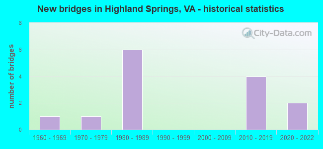
- New bridges - historical statistics
- 11960-1969
- 11970-1979
- 61980-1989
- 42010-2019
- 22020-2022


- Bridge Condition - Deck
- 20.0%Very good
- 40.0%Good
- 40.0%Fair

- Bridge Condition - Superstructure
- 60.0%Very good
- 20.0%Satisfactory
- 20.0%Fair

- Bridge Condition - Substructure
- 20.0%Very good
- 40.0%Good
- 40.0%Fair

- Bridge Condition - Channel
- 33.3%Satisfactory
- 50.0%Fair
- 16.7%Poor

- Bridge Condition - Culverts
- 60.0%Satisfactory
- 40.0%Fair
Find on map >> Show street view
Structure Number: 9416, Location: 0.0 to Henrico Co Line (Lat: 37.551692, Lng: -77.271267), Route carried "on" structure: State highway 156, Year Built: 1976, Status: Open, Structure Length: 7.85m (25.75ft), Average Daily Traffic: 5,317 (year 2020), Truck Traffic: 2%, Average Future Daily Traffic: 7,444 (year 2040), Design Load: HS 20+Mod, Features Intersected: Chickahominy River, Facility Carried by Structure: Cold Harbor Road
Minimum Vertical Clearance: 30+ m (98+ ft), Kilometerpoint: 82.304, Lanes on structure: 2, Owner: State Highway Agency, Approaching Roadway Width: 11.6m (38.1ft), Material/Design: Steel, Design/Construction: Stringer/Multi-beam, Number Of Spans In Main Unit: 3, Length of Maximum Span: 25.6m (84.0ft), Curb-To-Curb Width: 11.6m (38.1ft), Out-to-Out Width: 12.8m (42.0ft)
Condition: Deck: Fair, Superstructure: Fair, Substructure: Fair, Channel: Satisfactory, Operating Rating: 82.6 metric tons, Method Used To Determine Operating Rating: Load and Resistance Factor (LRFR), Inventory Rating: 63.8 metric tons, Method Used To Determine Inventory Rating: Load and Resistance Factor (LRFR), Structural Evaluation: Somewhat better than minimum adequacy, Deck Geometry: Somewhat better than minimum adequacy, Waterway Adequacy: Equal to present desirable criteria, Approach Roadway Alignment: Equal to present desirable criteria, Designated Inspection Frequency: Every 24 months, Inspection Date: May 2020, Deck Structure Type: Concrete Cast-file-Place
Find on map >> Show street view
Structure Number: 9866, Location: 0.83HANOVE CO & 2.12 TO33 (Lat: 37.549517, Lng: -77.286528), Route carried "on" structure: State highway 156, Year Built: 1980, Status: Open, Structure Length: 11.04m (36.22ft), Average Daily Traffic: 4,253 (year 2020), Truck Traffic: 3%, Average Future Daily Traffic: 5,954 (year 2040), Design Load: HS 20+Mod, Features Intersected: RTE I 295, Facility Carried by Structure: AIRPORT DRIVE NORT
Minimum Vertical Clearance: 30+ m (98+ ft), Kilometerpoint: 80.855, Lanes on structure: 6, Lanes under structure: 10, Owner: State Highway Agency, Approaching Roadway Width: 31.2m (102.4ft), Skew: 21 degrees, Material/Design: Steel continuous, Design/Construction: Stringer/Multi-beam, Number Of Spans In Main Unit: 2, Length of Maximum Span: 54.6m (179.1ft), Curb-To-Curb Width: 31.2m (102.4ft), Out-to-Out Width: 32.3m (106.0ft)
Condition: Deck: Fair, Superstructure: Satisfactory, Substructure: Fair, Operating Rating: 67.9 metric tons, Method Used To Determine Operating Rating: Load and Resistance Factor (LRFR), Inventory Rating: 52.4 metric tons, Method Used To Determine Inventory Rating: Load and Resistance Factor (LRFR), Structural Evaluation: Somewhat better than minimum adequacy, Deck Geometry: Superior to present desirable criteria, Underclear: Better than present minimum criteria, Approach Roadway Alignment: Equal to present desirable criteria, Designated Inspection Frequency: Every 24 months, Inspection Date: July 2021, Deck Structure Type: Concrete Cast-file-Place, Wearing Surface/Protective System: Deck Protection: Epoxy Coated Reinforcing
Find on map >> Show street view
Structure Number: 9869, Location: .39 TO 295 & .46 TO 043CL (Lat: 37.549756, Lng: -77.278797), Route carried "on" structure: State highway 156, Year Built: 1980, Status: Open, Structure Length: 0.98m (3.22ft), Average Daily Traffic: 4,253 (year 2020), Truck Traffic: 2%, Average Future Daily Traffic: 5,954 (year 2040), Design Load: HS 20+Mod, Features Intersected: TRIB OF CHICKAHOMNY RV, Facility Carried by Structure: AIRPORT DRIVE N.
Minimum Vertical Clearance: 30+ m (98+ ft), Kilometerpoint: 81.551, Lanes on structure: 4, Owner: State Highway Agency, Approaching Roadway Width: 14.6m (47.9ft), Skew: 22 degrees, Material/Design: Concrete, Design/Construction: Culvert, Number Of Spans In Main Unit: 4, Length of Maximum Span: 2.1m (6.9ft)
Condition: Channel: Fair, Culverts: Satisfactory, Operating Rating: 54.4 metric tons, Method Used To Determine Operating Rating: Field evaluation and documented engineering judgment, Inventory Rating: 32.7 metric tons, Method Used To Determine Inventory Rating: Field evaluation and documented engineering judgment, Structural Evaluation: Equal to present minimum criteria, Waterway Adequacy: Equal to present desirable criteria, Approach Roadway Alignment: Equal to present desirable criteria, Designated Inspection Frequency: Every 24 months, Inspection Date: September 2021
Find on map >> Show street view
Structure Number: 987, Location: 0.34 TO 295 & 1.76 TO 33 (Lat: 37.548614, Lng: -77.291758), Route carried "on" structure: State highway 156, Year Built: 1980, Status: Open, Structure Length: 1.17m (3.84ft), Average Daily Traffic: 13,109 (year 2020), Truck Traffic: 2%, Average Future Daily Traffic: 18,152 (year 2040), Design Load: HS 20+Mod, Features Intersected: BROAD WATER SWAMP, Facility Carried by Structure: AIRPORT DRIVE N.
Minimum Vertical Clearance: 30+ m (98+ ft), Kilometerpoint: 80.374, Lanes on structure: 4, Owner: State Highway Agency, Approaching Roadway Width: 21.9m (71.9ft), Skew: 23 degrees, Material/Design: Concrete, Design/Construction: Culvert, Number Of Spans In Main Unit: 3, Length of Maximum Span: 3.7m (12.1ft)
Condition: Channel: Fair, Culverts: Satisfactory, Operating Rating: 54.4 metric tons, Method Used To Determine Operating Rating: Field evaluation and documented engineering judgment, Inventory Rating: 32.7 metric tons, Method Used To Determine Inventory Rating: Field evaluation and documented engineering judgment, Structural Evaluation: Equal to present minimum criteria, Waterway Adequacy: Equal to present desirable criteria, Approach Roadway Alignment: Equal to present desirable criteria, Designated Inspection Frequency: Every 24 months, Inspection Date: October 2021
Find on map >> Show street view
Structure Number: 9871, Location: 0.69E WASH ST & .34 TO 33 (Lat: 37.540222, Lng: -77.315419), Route carried "on" structure: State highway 156, Year Built: 1960, Status: Open, Structure Length: 0.67m (2.20ft), Average Daily Traffic: 13,109 (year 2020), Truck Traffic: 6%, Average Future Daily Traffic: 18,152 (year 2040), Design Load: HS 20, Features Intersected: TUCKERS BRANCH, Facility Carried by Structure: N. AIRPORT DRIVE
Minimum Vertical Clearance: 30+ m (98+ ft), Kilometerpoint: 78.030, Lanes on structure: 4, Owner: State Highway Agency, Approaching Roadway Width: 16.8m (55.1ft), Skew: 24 degrees, Material/Design: Concrete, Design/Construction: Culvert, Number Of Spans In Main Unit: 2, Length of Maximum Span: 3.2m (10.5ft)
Condition: Channel: Satisfactory, Culverts: Fair, Operating Rating: 54.4 metric tons, Method Used To Determine Operating Rating: Field evaluation and documented engineering judgment, Inventory Rating: 32.7 metric tons, Method Used To Determine Inventory Rating: Field evaluation and documented engineering judgment, Structural Evaluation: Somewhat better than minimum adequacy, Waterway Adequacy: Equal to present desirable criteria, Approach Roadway Alignment: Equal to present desirable criteria, Designated Inspection Frequency: Every 24 months, Inspection Date: November 2020
Find on map >> Show street view
Structure Number: 9947, Location: 0.20 Fr 295 & 0.15 TO 156 (Lat: 37.550831, Lng: -77.288814), Route carried "on" structure: Ramp Interstate 295, Year Built: 1980, Status: Open, Structure Length: 1.47m (4.82ft), Average Daily Traffic: 6,375 (year 2020), Average Future Daily Traffic: 8,527 (year 2040), Design Load: HS 20+Mod, Features Intersected: BROADWATER SWAMP
Minimum Vertical Clearance: 30+ m (98+ ft), Kilometerpoint: 0.000, Lanes on structure: 1, Base Highway Network: Yes, Owner: State Highway Agency, Approaching Roadway Width: 9.8m (32.2ft), Skew: 4 degrees, Material/Design: Concrete, Design/Construction: Culvert, Number Of Spans In Main Unit: 4, Length of Maximum Span: 3.4m (11.2ft)
Condition: Channel: Poor, Culverts: Satisfactory, Operating Rating: 54.4 metric tons, Method Used To Determine Operating Rating: Field evaluation and documented engineering judgment, Inventory Rating: 32.7 metric tons, Method Used To Determine Inventory Rating: Field evaluation and documented engineering judgment, Structural Evaluation: Equal to present minimum criteria, Waterway Adequacy: Better than present minimum criteria, Approach Roadway Alignment: Equal to present desirable criteria, Designated Inspection Frequency: Every 24 months, Inspection Date: October 2021
Find on map >> Show street view
Structure Number: 9948, Location: 3.10 fr 615 & .19 to 156 (Lat: 37.551756, Lng: -77.287794), Route carried "on" structure: Interstate 295, Year Built: 1980, Status: Open, Structure Length: 1.08m (3.54ft), Average Daily Traffic: 60,023 (year 2020), Truck Traffic: 1%, Average Future Daily Traffic: 84,032 (year 2040), Design Load: HS 20+Mod, Features Intersected: BROAD WATER SWAMP
Minimum Vertical Clearance: 30+ m (98+ ft), Kilometerpoint: 34.368, Lanes on structure: 9, Base Highway Network: Yes, Owner: State Highway Agency, Approaching Roadway Width: 41.5m (136.2ft), Skew: 21 degrees, Material/Design: Concrete, Design/Construction: Culvert, Number Of Spans In Main Unit: 4, Length of Maximum Span: 2.5m (8.2ft)
Condition: Channel: Fair, Culverts: Fair, Operating Rating: 54.4 metric tons, Method Used To Determine Operating Rating: Field evaluation and documented engineering judgment, Inventory Rating: 32.7 metric tons, Method Used To Determine Inventory Rating: Field evaluation and documented engineering judgment, Structural Evaluation: Somewhat better than minimum adequacy, Waterway Adequacy: Equal to present desirable criteria, Approach Roadway Alignment: Equal to present desirable criteria, Designated Inspection Frequency: Every 24 months, Inspection Date: November 2021
Find on map >> Show street view
Structure Number: 30208, Location: 0.79 MI FR 156 & 2.33 295 (Lat: 37.529189, Lng: -77.312006), Route carried "on" structure: Interstate 64, Year Built: 2016, Status: Open, Structure Length: 3.62m (11.88ft), Average Daily Traffic: 16,154 (year 2020), Truck Traffic: 4%, Average Future Daily Traffic: 22,616 (year 2040), Design Load: HS 20+Mod, Features Intersected: ROUTE 33
Minimum Vertical Clearance: 4.65m (15.26ft), Kilometerpoint: 0.000, Lanes on structure: 2, Lanes under structure: 2, Base Highway Network: Yes, Owner: State Highway Agency, Approaching Roadway Width: 7.3m (24.0ft), Skew: 3 degrees, Material/Design: Steel, Design/Construction: Stringer/Multi-beam, Number Of Spans In Main Unit: 1, Length of Maximum Span: 34.1m (111.9ft), Curb-To-Curb Width: 19.0m (62.3ft), Out-to-Out Width: 19.5m (64.0ft)
Condition: Deck: Good, Superstructure: Very good, Substructure: Good, Operating Rating: 87.1 metric tons, Method Used To Determine Operating Rating: Load and Resistance Factor (LRFR), Inventory Rating: 67.1 metric tons, Method Used To Determine Inventory Rating: Load and Resistance Factor (LRFR), Structural Evaluation: Better than present minimum criteria, Deck Geometry: Superior to present desirable criteria, Underclear: Equal to present minimum criteria, Approach Roadway Alignment: Equal to present desirable criteria, Designated Inspection Frequency: Every 24 months, Inspection Date: December 2020, Deck Structure Type: Concrete Cast-file-Place, Wearing Surface/Protective System: Wearing Surface: Monolithic Concrete, Deck Protection: Other Coated Reinforcing
Find on map >> Show street view
Structure Number: 30209, Location: 2.33 I-295 & 0.80 to 156 (Lat: 37.529500, Lng: -77.312200), Route carried "on" structure: Interstate 64, Year Built: 2016, Status: Open, Structure Length: 3.62m (11.88ft), Average Daily Traffic: 15,392 (year 2020), Truck Traffic: 4%, Average Future Daily Traffic: 21,549 (year 2040), Design Load: HS 20+Mod, Features Intersected: ROUTE 33
Minimum Vertical Clearance: 30+ m (98+ ft), Kilometerpoint: 0.000, Lanes on structure: 2, Lanes under structure: 2, Base Highway Network: Yes, Owner: State Highway Agency, Approaching Roadway Width: 7.3m (24.0ft), Skew: 3 degrees, Material/Design: Steel, Design/Construction: Stringer/Multi-beam, Number Of Spans In Main Unit: 1, Length of Maximum Span: 34.1m (111.9ft), Curb-To-Curb Width: 19.0m (62.3ft), Out-to-Out Width: 19.5m (64.0ft)
Condition: Deck: Good, Superstructure: Very good, Substructure: Good, Operating Rating: 87.1 metric tons, Method Used To Determine Operating Rating: Load and Resistance Factor (LRFR), Inventory Rating: 67.1 metric tons, Method Used To Determine Inventory Rating: Load and Resistance Factor (LRFR), Structural Evaluation: Better than present minimum criteria, Deck Geometry: Superior to present desirable criteria, Underclear: Better than present minimum criteria, Approach Roadway Alignment: Equal to present minimum criteria, Designated Inspection Frequency: Every 24 months, Inspection Date: December 2020, Deck Structure Type: Concrete Cast-file-Place, Wearing Surface/Protective System: Wearing Surface: Monolithic Concrete, Deck Protection: Other Coated Reinforcing
Find on map >> Show street view
Structure Number: 30233, Location: 1.9 FR 7555, 2.6 to 295 (Lat: 37.529828, Lng: -77.327211), Route carried "on" structure: Interstate 64, Year Built: 2020, Status: Open, Structure Length: 4.61m (15.12ft), Average Daily Traffic: 31,546 (year 2020), Truck Traffic: 4%, Average Future Daily Traffic: 33,820 (year 2040), Design Load: HL 93, Features Intersected: RTE. 156 AIRPORT DR.
Minimum Vertical Clearance: 30+ m (98+ ft), Kilometerpoint: 318.457, Lanes on structure: 5, Lanes under structure: 4, Owner: State Highway Agency, Approaching Roadway Width: 43.9m (144.0ft), Skew: 31 degrees, Material/Design: Steel, Design/Construction: Stringer/Multi-beam, Number Of Spans In Main Unit: 2, Length of Maximum Span: 22.3m (73.2ft), Curb-To-Curb Width: 43.9m (144.0ft), Out-to-Out Width: 45.8m (150.3ft)
Condition: Deck: Very good, Superstructure: Very good, Substructure: Very good, Operating Rating: 69.7 metric tons, Method Used To Determine Operating Rating: Load and Resistance Factor (LRFR), Inventory Rating: 53.8 metric tons, Method Used To Determine Inventory Rating: Load and Resistance Factor (LRFR), Structural Evaluation: Equal to present desirable criteria, Deck Geometry: Superior to present desirable criteria, Underclear: Meets minimum limits, Approach Roadway Alignment: Somewhat better than minimum adequacy, Designated Inspection Frequency: Every 24 months, Inspection Date: July 2020, Deck Structure Type: Concrete Cast-file-Place, Wearing Surface/Protective System: Wearing Surface: Latex Concrete, Deck Protection: Other Coated Reinforcing
Find on map >> Show street view
Structure Number: 9866, Location: 0.83HANOVE CO & 2.12 TO33 (Lat: 37.549517, Lng: -77.286528), Route carried "under" structure: Interstate 295, Year Built: 1980, Structure Length: 0. m, Average Daily Traffic: 60,000 (year 2020), Truck Traffic: 11%, Features Intersected: RTE I 295, Facility Carried by Structure: AIRPORT DRIVE NORT
Minimum Vertical Clearance: 5.79m (19.00ft), Kilometerpoint: 35.205, Lanes on structure: 6, Lanes under structure: 8, Material/Design: Steel continuous, Design/Construction: Stringer/Multi-beam, Length of Maximum Span: 54.6m (179.1ft)
Find on map >> Show street view
Structure Number: 30208, Location: 0.79 MI FR 156 & 2.33 295 (Lat: 37.529189, Lng: -77.312006), Route carried "under" structure: State highway 33, Year Built: 2016, Structure Length: 0. m, Average Daily Traffic: 1,600 (year 2019), Truck Traffic: 3%, Features Intersected: ROUTE 33, Facility Carried by Structure: I-64 EBL
Minimum Vertical Clearance: 4.65m (15.26ft), Kilometerpoint: 0.000, Lanes on structure: 2, Lanes under structure: 2, Material/Design: Steel, Design/Construction: Stringer/Multi-beam, Length of Maximum Span: 34.1m (111.9ft)
Find on map >> Show street view
Structure Number: 30209, Location: 2.33 I-295 & 0.80 to 156 (Lat: 37.529500, Lng: -77.312200), Route carried "under" structure: Interstate 64, Year Built: 2016, Structure Length: 0. m, Average Daily Traffic: 1,600 (year 2019), Truck Traffic: 3%, Features Intersected: ROUTE 33
Minimum Vertical Clearance: 4.72m (15.49ft), Kilometerpoint: 0.000, Lanes on structure: 2, Lanes under structure: 2, Material/Design: Steel, Design/Construction: Stringer/Multi-beam, Length of Maximum Span: 34.1m (111.9ft)
Find on map >> Show street view
Structure Number: 30233, Location: 1.9 FR 7555, 2.6 to 295 (Lat: 37.529828, Lng: -77.327211), Route carried "under" structure: State highway 156, Year Built: 2020, Structure Length: 0. m, Average Daily Traffic: 46,000 (year 2020), Truck Traffic: 5%, Features Intersected: RTE. 156 AIRPORT DR., Facility Carried by Structure: Route 00064
Minimum Vertical Clearance: 5.41m (17.75ft), Kilometerpoint: 76.412, Lanes on structure: 5, Lanes under structure: 4, Material/Design: Steel, Design/Construction: Stringer/Multi-beam, Length of Maximum Span: 22.3m (73.2ft)