Bridge Statistics for Hanover Park, Illinois (IL)
Condition, Traffic, Stress, Structural Evaluation, Project Costs
- National Bridge Inventory (NBI) Statistics
- 13Number of bridges
- 354ft / 108mTotal length
- 265,200Total average daily traffic
- 19,458Total average daily truck traffic
- National Bridge Inventory (NBI) Registered Bridges for Hanover Park
- No street view available for this location
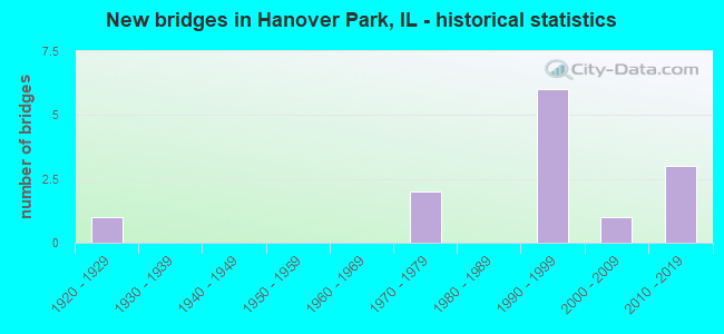
- New bridges - historical statistics
- 11920-1929
- 21970-1979
- 61990-1999
- 12000-2009
- 32010-2019


- Bridge Condition - Deck
- 33.3%Good
- 16.7%Satisfactory
- 33.3%Fair
- 16.7%Poor

- Bridge Condition - Superstructure
- 50.0%Very good
- 16.7%Good
- 16.7%Fair
- 16.7%Critical

- Bridge Condition - Substructure
- 16.7%Very good
- 33.3%Good
- 16.7%Satisfactory
- 16.7%Fair
- 16.7%Critical

- Bridge Condition - Channel
- 12.5%Excellent
- 25.0%Very good
- 37.5%Good
- 25.0%Poor

- Bridge Condition - Culverts
- 66.7%Good
- 33.3%Satisfactory
Find on map >> Show street view
Structure Number: 162565, Location: .8M E OF US 20 (Lat: 41.988389, Lng: -88.128058), Route carried "on" structure: State highway 390, Year Built: 1993, Status: Open, Structure Length: 46.89m (153.84ft), Average Daily Traffic: 28,600 (year 2017), Truck Traffic: 8%, Average Future Daily Traffic: 17,613 (year 2032), Design Load: HS 20, Features Intersected: RR - METRA, WETLANDS
Minimum Vertical Clearance: 30+ m (98+ ft), Kilometerpoint: 1.239, Lanes on structure: 2, Base Highway Network: Yes, Toll: On toll road, Owner: State Toll Authority, Approaching Roadway Width: 17.1m (56.1ft), Material/Design: Steel continuous, Design/Construction: Stringer/Multi-beam, Number Of Spans In Main Unit: 12, Length of Maximum Span: 46.3m (151.9ft), Curb-To-Curb Width: 17.1m (56.1ft), Out-to-Out Width: 18.0m (59.1ft)
Condition: Deck: Fair, Superstructure: Very good, Substructure: Satisfactory, Channel: Very good, Operating Rating: 66.7 metric tons, Method Used To Determine Operating Rating: Load Factor (LF) rating reported by rating factor (RF) method using MS18 loading, Inventory Rating: 40.2 metric tons, Method Used To Determine Inventory Rating: Load Factor (LF) rating reported by rating factor (RF) method using MS18 loading, Structural Evaluation: Equal to present minimum criteria, Deck Geometry: Superior to present desirable criteria, Underclear: High priority of corrective action, Waterway Adequacy: Equal to present desirable criteria, Approach Roadway Alignment: Equal to present desirable criteria, Designated Inspection Frequency: Every 24 months, Inspection Date: May 2019, Deck Structure Type: Concrete Cast-file-Place, Wearing Surface/Protective System: Deck Protection: Epoxy Coated Reinforcing
Find on map >> Show street view
Structure Number: 162566, Location: .8 M E OF US 20 (Lat: 41.988106, Lng: -88.128431), Route carried "on" structure: State highway 390, Year Built: 1993, Status: Open, Structure Length: 42.78m (140.35ft), Average Daily Traffic: 28,600 (year 2017), Truck Traffic: 8%, Average Future Daily Traffic: 17,613 (year 2032), Design Load: HS 20, Features Intersected: RR - METRA, WETLANDS
Minimum Vertical Clearance: 30+ m (98+ ft), Kilometerpoint: 1.207, Lanes on structure: 2, Base Highway Network: Yes, Toll: On toll road, Owner: State Toll Authority, Approaching Roadway Width: 17.1m (56.1ft), Material/Design: Steel continuous, Design/Construction: Stringer/Multi-beam, Number Of Spans In Main Unit: 11, Length of Maximum Span: 46.3m (151.9ft), Curb-To-Curb Width: 17.1m (56.1ft), Out-to-Out Width: 18.0m (59.1ft)
Condition: Deck: Good, Superstructure: Very good, Substructure: Good, Channel: Excellent, Operating Rating: 59.9 metric tons, Method Used To Determine Operating Rating: Load Factor (LF) rating reported by rating factor (RF) method using MS18 loading, Inventory Rating: 36.0 metric tons, Method Used To Determine Inventory Rating: Load Factor (LF) rating reported by rating factor (RF) method using MS18 loading, Structural Evaluation: Better than present minimum criteria, Deck Geometry: Superior to present desirable criteria, Underclear: High priority of corrective action, Waterway Adequacy: Superior to present desirable criteria, Approach Roadway Alignment: Equal to present desirable criteria, Designated Inspection Frequency: Every 24 months, Inspection Date: May 2019, Deck Structure Type: Concrete Cast-file-Place, Wearing Surface/Protective System: Deck Protection: Epoxy Coated Reinforcing
Find on map >> Show street view
Structure Number: 166046, Location: S. OF IL RTE 19 (Lat: 42.000692, Lng: -88.136097), Route carried "on" structure: City street , Year Built: 2013, Status: Open, Structure Length: 0.76m (2.49ft), Average Daily Traffic: 600 (year 2018), Truck Traffic: 4%, Average Future Daily Traffic: 318 (year 2032), Design Load: HS 25 or greater, Features Intersected: W Br DuPage River, Facility Carried by Structure: MS-1170
Minimum Vertical Clearance: 30+ m (98+ ft), Kilometerpoint: 0.370, Lanes on structure: 2, Owner: City or Municipal Highway Agency, Approaching Roadway Width: 7.9m (25.9ft), Material/Design: Concrete continuous, Design/Construction: Culvert, Number Of Spans In Main Unit: 2, Length of Maximum Span: 4.0m (13.1ft), Curb or Sidewalk Widths: Left: 3.7m (12.1ft), Right: 0.0m, Curb-To-Curb Width: 8.5m (27.9ft), Out-to-Out Width: 13.7m (44.9ft)
Condition: Channel: Very good, Culverts: Good, Operating Rating: 42.1 metric tons, Method Used To Determine Operating Rating: Assigned ratings based on Load and Resistance Factor Design (LRFD) reported by rating factor (RF) using HL93 loadings, Inventory Rating: 32.4 metric tons, Method Used To Determine Inventory Rating: Assigned ratings based on Load and Resistance Factor Design (LRFD) reported by rating factor (RF) using HL93 loadings, Structural Evaluation: Better than present minimum criteria, Deck Geometry: Somewhat better than minimum adequacy, Waterway Adequacy: Superior to present desirable criteria, Approach Roadway Alignment: Equal to present desirable criteria, Designated Inspection Frequency: Every 48 months, Inspection Date: October 2019, Deck Structure Type: Concrete Cast-file-Place, Wearing Surface/Protective System: Wearing Surface: Bituminous, Deck Protection: Epoxy Coated Reinforcing
Find on map >> Show street view
Structure Number: 16633, Location: .6 M S/RTE 19 (Lat: 41.995714, Lng: -88.137633), Route carried "on" structure: City street , Year Built: 1979, Status: Open, Structure Length: 1.00m (3.28ft), Average Daily Traffic: 2,550 (year 2018), Truck Traffic: 3%, Average Future Daily Traffic: 3,202 (year 2032), Design Load: HS 20, Features Intersected: W BRANCH OF DUPAGE, Facility Carried by Structure: WALNUT AVE.
Minimum Vertical Clearance: 30+ m (98+ ft), Kilometerpoint: 2.253, Lanes on structure: 2, Owner: City or Municipal Highway Agency, Approaching Roadway Width: 7.9m (25.9ft), Material/Design: Concrete continuous, Design/Construction: Culvert, Number Of Spans In Main Unit: 3, Length of Maximum Span: 3.3m (10.8ft), Curb or Sidewalk Widths: Left: 1.8m (5.9ft), Right: 0.0m, Curb-To-Curb Width: 7.9m (25.9ft), Out-to-Out Width: 12.2m (40.0ft)
Condition: Channel: Good, Culverts: Good, Operating Rating: 89.1 metric tons, Method Used To Determine Operating Rating: Load Factor (LF) rating reported by rating factor (RF) method using MS18 loading, Inventory Rating: 67.4 metric tons, Method Used To Determine Inventory Rating: Load Factor (LF) rating reported by rating factor (RF) method using MS18 loading, Structural Evaluation: Better than present minimum criteria, Deck Geometry: High priority of corrective action, Waterway Adequacy: Superior to present desirable criteria, Approach Roadway Alignment: Equal to present desirable criteria, Designated Inspection Frequency: Every 48 months, Inspection Date: April 2019, Wearing Surface/Protective System: Wearing Surface: Bituminous
Find on map >> Show street view
Structure Number: 220205, Location: EAST OF LAKE STREET (Lat: 41.983847, Lng: -88.134042), Route carried "on" structure: State highway 390, Year Built: 1992, Status: Open, Structure Length: 1.07m (3.51ft), Average Daily Traffic: 28,600 (year 2017), Truck Traffic: 4%, Average Future Daily Traffic: 10,360 (year 2032), Design Load: HS 20, Features Intersected: W BR DU PAGE RIVER
Minimum Vertical Clearance: 30+ m (98+ ft), Kilometerpoint: 0.612, Lanes on structure: 2, Base Highway Network: Yes, Toll: On toll road, Owner: State Toll Authority, Approaching Roadway Width: 36.6m (120.1ft), Skew: 13 degrees, Material/Design: Concrete continuous, Design/Construction: Culvert, Number Of Spans In Main Unit: 2, Length of Maximum Span: 2.3m (7.5ft)
Condition: Channel: Poor, Culverts: Satisfactory, Operating Rating: 51.2 metric tons, Method Used To Determine Operating Rating: Load Factor (LF) rating reported by rating factor (RF) method using MS18 loading, Inventory Rating: 30.8 metric tons, Method Used To Determine Inventory Rating: Load Factor (LF) rating reported by rating factor (RF) method using MS18 loading, Structural Evaluation: Equal to present minimum criteria, Waterway Adequacy: Equal to present desirable criteria, Approach Roadway Alignment: Equal to present desirable criteria, Designated Inspection Frequency: Every 24 months, Inspection Date: April 2021
Find on map >> Show street view
Structure Number: 220208, Location: EAST OF BARRINGTON R (Lat: 41.981575, Lng: -88.139319), Route carried "on" structure: US 20, Year Built: 1992, Status: Open, Structure Length: 7.35m (24.11ft), Average Daily Traffic: 33,400 (year 2021), Truck Traffic: 9%, Average Future Daily Traffic: 19,105 (year 2032), Features Intersected: IL 390 ELGIN-OHARE
Minimum Vertical Clearance: 4.95m (16.24ft), Kilometerpoint: 246.078, Lanes on structure: 2, Lanes under structure: 2, Base Highway Network: Yes, Toll: On toll road, Owner: State Highway Agency, Approaching Roadway Width: 39.8m (130.6ft), Skew: 30 degrees, Material/Design: Steel continuous, Design/Construction: Stringer/Multi-beam, Number Of Spans In Main Unit: 2, Length of Maximum Span: 39.9m (130.9ft), Curb-To-Curb Width: 23.6m (77.4ft), Out-to-Out Width: 41.9m (137.5ft)
Condition: Deck: Satisfactory, Superstructure: Good, Substructure: Good, Operating Rating: 64.5 metric tons, Method Used To Determine Operating Rating: Load Factor (LF) rating reported by rating factor (RF) method using MS18 loading, Inventory Rating: 38.6 metric tons, Method Used To Determine Inventory Rating: Load Factor (LF) rating reported by rating factor (RF) method using MS18 loading, Structural Evaluation: Better than present minimum criteria, Deck Geometry: Superior to present desirable criteria, Underclear: Meets minimum limits, Approach Roadway Alignment: Better than present minimum criteria, Designated Inspection Frequency: Every 24 months, Inspection Date: April 2021, Deck Structure Type: Concrete Cast-file-Place, Wearing Surface/Protective System: Deck Protection: Epoxy Coated Reinforcing
Find on map >> Show street view
Structure Number: 220548, Location: 0.18 M E Greenbrook (Lat: 41.978325, Lng: -88.133192), Route carried "on" structure: US 20, Year Built: 2017, Status: Open, Structure Length: 2.59m (8.50ft), Average Daily Traffic: 33,400 (year 2021), Truck Traffic: 9%, Average Future Daily Traffic: 35,500 (year 2042), Design Load: HS 25 or greater, Features Intersected: W BR DU PAGE RIVER
Minimum Vertical Clearance: 32.69m (107.25ft), Kilometerpoint: 246.690, Lanes on structure: 4, Base Highway Network: Yes, Owner: State Highway Agency, Approaching Roadway Width: 27.4m (89.9ft), Skew: 23 degrees, Material/Design: Prestressed concrete, Design/Construction: Stringer/Multi-beam, Number Of Spans In Main Unit: 1, Length of Maximum Span: 24.5m (80.4ft), Curb or Sidewalk Widths: Left: 2.3m (7.5ft), Right: 3.0m (9.8ft), Curb-To-Curb Width: 28.7m (94.2ft), Out-to-Out Width: 34.8m (114.2ft)
Condition: Deck: Good, Superstructure: Very good, Substructure: Very good, Channel: Good, Operating Rating: 62.2 metric tons, Method Used To Determine Operating Rating: Load and Resistance Factor Rating (LRFR) rating reported by rating factor(RF) method using HL-93 loadings, Inventory Rating: 48.0 metric tons, Method Used To Determine Inventory Rating: Load and Resistance Factor Rating (LRFR) rating reported by rating factor(RF) method using HL-93 loadings, Structural Evaluation: Equal to present desirable criteria, Deck Geometry: Superior to present desirable criteria, Waterway Adequacy: Equal to present desirable criteria, Approach Roadway Alignment: Equal to present desirable criteria, Designated Inspection Frequency: Every 24 months, Inspection Date: December 2021, Deck Structure Type: Concrete Cast-file-Place, Wearing Surface/Protective System: Deck Protection: Epoxy Coated Reinforcing
Find on map >> Show street view
Structure Number: 227451, Location: 0.5M S US-20 (Lat: 41.974944, Lng: -88.138772), Route carried "on" structure: Other road , Year Built: 1971, Status: Posted for load, Structure Length: 3.22m (10.56ft), Average Daily Traffic: 2,350 (year 2020), Truck Traffic: 3%, Average Future Daily Traffic: 5,068 (year 2032), Design Load: HS 20, Features Intersected: W BRANCH DUPAGE RIV, Facility Carried by Structure: ARLINGTON Drive
Minimum Vertical Clearance: 30+ m (98+ ft), Kilometerpoint: 10.525, Lanes on structure: 4, Owner: City or Municipal Highway Agency, Approaching Roadway Width: 18.3m (60.0ft), Skew: 24 degrees, Material/Design: Prestressed concrete, Design/Construction: Box Beam or Girders - Multiple, Number Of Spans In Main Unit: 3, Length of Maximum Span: 9.8m (32.2ft), Curb or Sidewalk Widths: Left: 2.0m (6.6ft), Right: 2.4m (7.9ft), Curb-To-Curb Width: 10.5m (34.4ft), Out-to-Out Width: 18.3m (60.0ft)
Condition: Deck: Poor, Superstructure: Critical, Substructure: Critical, Channel: Poor, Operating Rating: 6.5 metric tons, Method Used To Determine Operating Rating: Allowable Stress (AS) rating reported by rating factor (RF) method using MS18 loading, Structural Evaluation: High priority of replacement, Deck Geometry: High priority of replacement, Waterway Adequacy: Better than present minimum criteria, Approach Roadway Alignment: Better than present minimum criteria, Bridge Posting: Required (Relationship of Operating Rating to Maximum Legal Load: > 39.9% below), Designated Inspection Frequency: Every 24 months, Other Special Inspection Frequency: Every 3 months, Inspection Date: March 2021, Other Special Inspection Date: Febuary 2022, Deck Structure Type: Concrete Precast Panels, Wearing Surface/Protective System: Wearing Surface: Integral Concrete, Deck Protection: Epoxy Coated Reinforcing
Find on map >> Show street view
Structure Number: 227452, Location: 0.5 MI S Sterns Rd (Lat: 41.966856, Lng: -88.151614), Route carried "on" structure: Other road , Year Built: 1929, Year Reconstructed: 1989, Status: Open, Structure Length: 2.16m (7.09ft), Average Daily Traffic: 17,100 (year 2020), Truck Traffic: 5%, Average Future Daily Traffic: 12,755 (year 2032), Design Load: HS 20, Features Intersected: W BRANCH DU PAGE RIV, Facility Carried by Structure: COUNTY FARM RD
Minimum Vertical Clearance: 30+ m (98+ ft), Kilometerpoint: 2.430, Lanes on structure: 4, Base Highway Network: Yes, Owner: County Highway Agency, Approaching Roadway Width: 15.8m (51.8ft), Skew: 2 degrees, Material/Design: Prestressed concrete, Design/Construction: Box Beam or Girders - Multiple, Number Of Spans In Main Unit: 1, Length of Maximum Span: 20.1m (65.9ft), Curb or Sidewalk Widths: Left: 1.6m (5.2ft), Right: 1.6m (5.2ft), Curb-To-Curb Width: 15.8m (51.8ft), Out-to-Out Width: 19.6m (64.3ft)
Condition: Deck: Fair, Superstructure: Fair, Substructure: Fair, Channel: Good, Operating Rating: 72.9 metric tons, Method Used To Determine Operating Rating: Load Factor (LF) rating reported by rating factor (RF) method using MS18 loading, Inventory Rating: 43.7 metric tons, Method Used To Determine Inventory Rating: Load Factor (LF) rating reported by rating factor (RF) method using MS18 loading, Structural Evaluation: Somewhat better than minimum adequacy, Deck Geometry: Meets minimum limits, Waterway Adequacy: Equal to present desirable criteria, Approach Roadway Alignment: Equal to present desirable criteria, Designated Inspection Frequency: Every 24 months, Inspection Date: August 2020, Deck Structure Type: Concrete Precast Panels, Wearing Surface/Protective System: Wearing Surface: Bituminous, Membrane: Built-up
Find on map >> Show street view
Structure Number: 162828, Location: .9M E OF BRRNGTN RD (Lat: 41.988222, Lng: -88.145086), Route carried "under" structure: US 20, Year Built: 2002, Structure Length: 0. m, Average Daily Traffic: 38,400 (year 2021), Truck Traffic: 11%, Features Intersected: US-20 (LAKE ST), Facility Carried by Structure: SOO RR
Minimum Vertical Clearance: 4.95m (16.24ft), Kilometerpoint: 245.112, Lanes under structure: 4, Length of Maximum Span: 20.1m (65.9ft)
Find on map >> Show street view
Structure Number: 220208, Location: EAST OF BARRINGTON R (Lat: 41.981575, Lng: -88.139319), Route carried "under" structure: State highway 390, Year Built: 1992, Structure Length: 0. m, Average Daily Traffic: 22,400 (year 2020), Truck Traffic: 4%, Features Intersected: IL 390 ELGIN-OHARE, Facility Carried by Structure: US 20
Minimum Vertical Clearance: 4.95m (16.24ft), Kilometerpoint: 0.000, Lanes on structure: 2, Lanes under structure: 2, Toll: On toll road, Material/Design: Steel continuous, Design/Construction: Stringer/Multi-beam, Length of Maximum Span: 39.9m (130.9ft)
Find on map >> Show street view
Structure Number: 223106, Location: .06 MI S IL-20 (Lat: 41.988083, Lng: -88.147175), Route carried "under" structure: Other road , Year Built: 1990, Structure Length: 0. m, Average Daily Traffic: 12,100 (year 2020), Truck Traffic: 6%, Features Intersected: COUNTY FARM ROAD, Facility Carried by Structure: SOO LINE/METRA RR
Minimum Vertical Clearance: 4.42m (14.50ft), Kilometerpoint: 0.016, Lanes under structure: 5, Material/Design: Steel, Design/Construction: Stringer/Multi-beam, Length of Maximum Span: 17.5m (57.4ft)
Find on map >> Show street view
Structure Number: 223186, Location: 075 MI N SCHICK RD (Lat: 41.962364, Lng: -88.151647), Route carried "under" structure: Other road , Year Built: 2016, Structure Length: 0. m, Average Daily Traffic: 17,100 (year 2020), Truck Traffic: 5%, Features Intersected: COUNTY FARM RD, Facility Carried by Structure: NCENTRAL DUPAGE TR
Minimum Vertical Clearance: 5.26m (17.26ft), Kilometerpoint: 2.929, Lanes under structure: 4, Material/Design: Steel, Length of Maximum Span: 48.8m (160.1ft)