Bridge Statistics for Hampton, Georgia (GA)
Condition, Traffic, Stress, Structural Evaluation, Project Costs
- National Bridge Inventory (NBI) Statistics
- 21Number of bridges
- 243ft / 74.0mTotal length
- $14,113,000Total costs
- 115,584Total average daily traffic
- 1,508Total average daily truck traffic
- National Bridge Inventory (NBI) Registered Bridges for Hampton
- No street view available for this location
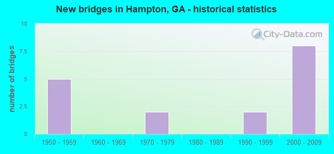
- New bridges - historical statistics
- 51950-1959
- 21970-1979
- 21990-1999
- 82000-2009


- Bridge Condition - Deck
- 80.0%Good
- 10.0%Satisfactory
- 10.0%Fair

- Bridge Condition - Superstructure
- 90.0%Good
- 10.0%Fair

- Bridge Condition - Substructure
- 70.0%Good
- 10.0%Satisfactory
- 20.0%Fair

- Bridge Condition - Channel
- 53.8%Very good
- 38.5%Good
- 7.7%Satisfactory
Find on map >> Show street view
Structure Number: 1510001, Location: .5 MI S OF HAMPTON (Lat: 33.365625, Lng: -84.293017), Route carried "on" structure: County highway 2009, Year Built: 1979, Status: Open, Structure Length: 5.97m (19.59ft), Average Daily Traffic: 4,120 (year 2011), Truck Traffic: 1%, Average Future Daily Traffic: 6,180 (year 2031), Design Load: HS 20+Mod, Features Intersected: CR 241- NOR-SOU RR
Minimum Vertical Clearance: 30+ m (98+ ft), Kilometerpoint: 1.609, Lanes on structure: 2, Lanes under structure: 2, Base Highway Network: Yes, Owner: County Highway Agency, Approaching Roadway Width: 7.3m (24.0ft), Skew: 3 degrees, Material/Design: Prestressed concrete, Design/Construction: Stringer/Multi-beam, Number Of Spans In Main Unit: 4, Length of Maximum Span: 17.7m (58.1ft), Curb-To-Curb Width: 13.4m (44.0ft), Out-to-Out Width: 14.4m (47.2ft)
Condition: Deck: Good, Superstructure: Good, Substructure: Good, Operating Rating: 64.4 metric tons, Method Used To Determine Operating Rating: Load Factor (LF), Inventory Rating: 36.2 metric tons, Method Used To Determine Inventory Rating: Load Factor (LF), Structural Evaluation: Better than present minimum criteria, Deck Geometry: Better than present minimum criteria, Underclear: Somewhat better than minimum adequacy, Approach Roadway Alignment: Better than present minimum criteria, Designated Inspection Frequency: Every 24 months, Inspection Date: October 2020, Bridge Improvement Cost: $766,000, Roadway Improvement Cost: $77,000, Total Project Cost: $1,149,000, Deck Structure Type: Concrete Cast-file-Place
Find on map >> Show street view
Structure Number: 1510002, Location: IN HAMPTON (Lat: 33.383542, Lng: -84.303150), Route carried "on" structure: US 19, Year Built: 1953, Status: Open, Structure Length: 0.98m (3.22ft), Average Daily Traffic: 21,580 (year 2011), Truck Traffic: 1%, Average Future Daily Traffic: 32,370 (year 2031), Design Load: H 15, Features Intersected: BEAR CREEK
Minimum Vertical Clearance: 30+ m (98+ ft), Kilometerpoint: 3.219, Lanes on structure: 5, Base Highway Network: Yes, Owner: State Highway Agency, Approaching Roadway Width: 18.3m (60.0ft), Skew: 10 degrees, Material/Design: Concrete, Design/Construction: Culvert, Number Of Spans In Main Unit: 3, Length of Maximum Span: 3.0m (9.8ft)
Condition: Channel: Very good, Culverts: Good, Structural Evaluation: Better than present minimum criteria, Waterway Adequacy: Equal to present minimum criteria, Approach Roadway Alignment: Better than present minimum criteria, Designated Inspection Frequency: Every 24 months, Inspection Date: October 2020, Bridge Improvement Cost: $227,000, Roadway Improvement Cost: $23,000, Total Project Cost: $341,000
Find on map >> Show street view
Structure Number: 1510051, Location: IN WESTSIDE OF HAMPTON (Lat: 33.381819, Lng: -84.305947), Route carried "on" structure: County highway 1070, Year Built: 1993, Status: Open, Structure Length: 1.34m (4.40ft), Average Daily Traffic: 6,680 (year 2012), Truck Traffic: 1%, Average Future Daily Traffic: 10,020 (year 2032), Design Load: H 15, Features Intersected: BEAR CREEK, Facility Carried by Structure: RICHARD PETTY BLVD
Minimum Vertical Clearance: 30+ m (98+ ft), Kilometerpoint: 1.609, Lanes on structure: 4, Base Highway Network: Yes, Owner: County Highway Agency, Approaching Roadway Width: 18.3m (60.0ft), Material/Design: Steel, Design/Construction: Culvert, Number Of Spans In Main Unit: 4, Length of Maximum Span: 2.4m (7.9ft)
Condition: Channel: Good, Culverts: Good, Operating Rating: 41.7 metric tons, Method Used To Determine Operating Rating: Field evaluation and documented engineering judgment, Inventory Rating: 24.4 metric tons, Method Used To Determine Inventory Rating: Field evaluation and documented engineering judgment, Structural Evaluation: Equal to present minimum criteria, Waterway Adequacy: Equal to present desirable criteria, Approach Roadway Alignment: Equal to present minimum criteria, Designated Inspection Frequency: Every 24 months, Underwater Inspection Frequency: Every 60 months, Inspection Date: October 2020, Underwater Inspection Date: December 2019, Bridge Improvement Cost: $266,000, Roadway Improvement Cost: $27,000, Total Project Cost: $399,000
Find on map >> Show street view
Structure Number: 1510053, Location: 2.5 MI E OF HAMPTON (Lat: 33.376275, Lng: -84.232447), Route carried "on" structure: County highway 1577, Year Built: 1950, Status: Posted for load, Structure Length: 4.11m (13.48ft), Average Daily Traffic: 4,480 (year 2011), Truck Traffic: 1%, Average Future Daily Traffic: 6,720 (year 2031), Design Load: H 10, Features Intersected: TOWALIGA RIVER, Facility Carried by Structure: HAMPTON ROAD
Minimum Vertical Clearance: 30+ m (98+ ft), Kilometerpoint: 4.828, Lanes on structure: 2, Base Highway Network: Yes, Owner: County Highway Agency, Approaching Roadway Width: 6.1m (20.0ft), Skew: 3 degrees, Material/Design: Steel continuous, Design/Construction: Stringer/Multi-beam, Number Of Spans In Main Unit: 5, Length of Maximum Span: 8.2m (26.9ft), Curb or Sidewalk Widths: Left: 0.2m (0.7ft), Right: 0.2m (0.7ft), Curb-To-Curb Width: 6.6m (21.7ft), Out-to-Out Width: 7.7m (25.3ft)
Condition: Deck: Satisfactory, Superstructure: Good, Substructure: Good, Channel: Very good, Operating Rating: 36.2 metric tons, Method Used To Determine Operating Rating: Load Factor (LF), Inventory Rating: 20.8 metric tons, Method Used To Determine Inventory Rating: Load Factor (LF), Structural Evaluation: Somewhat better than minimum adequacy, Deck Geometry: High priority of replacement, Waterway Adequacy: Equal to present minimum criteria, Approach Roadway Alignment: Better than present minimum criteria, Length Of Structure Improvement: 10.55m (34.61ft), Designated Inspection Frequency: Every 24 months, Inspection Date: October 2020, Bridge Improvement Cost: $527,000, Roadway Improvement Cost: $53,000, Total Project Cost: $791,000, Deck Structure Type: Concrete Cast-file-Place
Find on map >> Show street view
Structure Number: 1515028, Location: 1 MI E OF HAMPTON (Lat: 33.377611, Lng: -84.240172), Route carried "on" structure: County highway 285, Year Built: 1978, Year Reconstructed: 2011, Status: Open, Structure Length: 0.73m (2.40ft), Average Daily Traffic: 3,160 (year 2011), Truck Traffic: 1%, Average Future Daily Traffic: 4,740 (year 2031), Design Load: HS 20+Mod, Features Intersected: TOWALIGA RIVER, Facility Carried by Structure: ROCKY CREEK RD
Minimum Vertical Clearance: 30+ m (98+ ft), Kilometerpoint: 3.219, Lanes on structure: 3, Base Highway Network: Yes, Owner: County Highway Agency, Approaching Roadway Width: 6.1m (20.0ft), Skew: 3 degrees, Material/Design: Concrete, Design/Construction: Culvert, Number Of Spans In Main Unit: 2, Length of Maximum Span: 3.7m (12.1ft)
Condition: Channel: Very good, Culverts: Good, Operating Rating: 55.3 metric tons, Method Used To Determine Operating Rating: Field evaluation and documented engineering judgment, Inventory Rating: 32.6 metric tons, Method Used To Determine Inventory Rating: Field evaluation and documented engineering judgment, Structural Evaluation: Better than present minimum criteria, Waterway Adequacy: Equal to present desirable criteria, Approach Roadway Alignment: Equal to present desirable criteria, Designated Inspection Frequency: Every 24 months, Inspection Date: October 2020, Bridge Improvement Cost: $119,000, Roadway Improvement Cost: $12,000, Total Project Cost: $179,000
Find on map >> Show street view
Structure Number: 1515054, Location: CITY OF HAMPTON (Lat: 33.389889, Lng: -84.305350), Route carried "on" structure: City street 544, Year Built: 1991, Status: Open, Structure Length: 1.01m (3.31ft), Average Daily Traffic: 3,270 (year 2011), Truck Traffic: 1%, Average Future Daily Traffic: 4,905 (year 2031), Design Load: H 15, Features Intersected: BEAR CREEK, Facility Carried by Structure: OAK STREET
Minimum Vertical Clearance: 30+ m (98+ ft), Kilometerpoint: 1.609, Lanes on structure: 2, Base Highway Network: Yes, Owner: City or Municipal Highway Agency, Approaching Roadway Width: 6.1m (20.0ft), Material/Design: Steel, Design/Construction: Culvert, Number Of Spans In Main Unit: 3, Length of Maximum Span: 3.0m (9.8ft), Curb or Sidewalk Widths: Left: 0.0m, Right: 0.9m (3.0ft)
Condition: Channel: Good, Culverts: Good, Operating Rating: 41.7 metric tons, Method Used To Determine Operating Rating: Field evaluation and documented engineering judgment, Inventory Rating: 24.4 metric tons, Method Used To Determine Inventory Rating: Field evaluation and documented engineering judgment, Structural Evaluation: Equal to present minimum criteria, Waterway Adequacy: Better than present minimum criteria, Approach Roadway Alignment: Equal to present minimum criteria, Designated Inspection Frequency: Every 24 months, Inspection Date: October 2020, Bridge Improvement Cost: $129,000, Roadway Improvement Cost: $13,000, Total Project Cost: $193,000
Find on map >> Show street view
Structure Number: 1515069, Location: 1 MI W OF HAMPTON (Lat: 33.395917, Lng: -84.308397), Route carried "on" structure: County highway 2299, Year Built: 2003, Status: Open, Structure Length: 1.31m (4.30ft), Average Daily Traffic: 1,940 (year 2011), Truck Traffic: 1%, Average Future Daily Traffic: 2,910 (year 2031), Design Load: HS 20+Mod, Features Intersected: BEAR CREEK, Facility Carried by Structure: REVOLUTIONARY DR
Minimum Vertical Clearance: 30+ m (98+ ft), Kilometerpoint: 0.000, Lanes on structure: 2, Base Highway Network: Yes, Owner: County Highway Agency, Approaching Roadway Width: 8.2m (26.9ft), Material/Design: Concrete, Design/Construction: Culvert, Number Of Spans In Main Unit: 4, Length of Maximum Span: 3.0m (9.8ft), Curb or Sidewalk Widths: Left: 0.2m (0.7ft), Right: 0.2m (0.7ft)
Condition: Channel: Very good, Culverts: Good, Operating Rating: 55.3 metric tons, Method Used To Determine Operating Rating: Field evaluation and documented engineering judgment, Inventory Rating: 32.6 metric tons, Method Used To Determine Inventory Rating: Field evaluation and documented engineering judgment, Structural Evaluation: Better than present minimum criteria, Waterway Adequacy: Equal to present desirable criteria, Approach Roadway Alignment: Superior to present desirable criteria, Designated Inspection Frequency: Every 24 months, Inspection Date: October 2020, Bridge Improvement Cost: $168,000, Roadway Improvement Cost: $17,000, Total Project Cost: $252,000
Find on map >> Show street view
Structure Number: 1515077, Location: 2.5 MI W OF HAMPTON (Lat: 33.369100, Lng: -84.349208), Route carried "on" structure: County highway 1070, Year Built: 2004, Status: Open, Structure Length: 1.34m (4.40ft), Average Daily Traffic: 2,420 (year 2011), Truck Traffic: 1%, Average Future Daily Traffic: 3,630 (year 2031), Design Load: HS 20+Mod, Features Intersected: BEAR CREEK TRIB, Facility Carried by Structure: LOWER WOOLSEY RD
Minimum Vertical Clearance: 30+ m (98+ ft), Kilometerpoint: 0.000, Lanes on structure: 2, Base Highway Network: Yes, Owner: County Highway Agency, Approaching Roadway Width: 6.1m (20.0ft), Material/Design: Concrete, Design/Construction: Culvert, Number Of Spans In Main Unit: 4, Length of Maximum Span: 3.0m (9.8ft)
Condition: Channel: Very good, Culverts: Good, Operating Rating: 55.3 metric tons, Method Used To Determine Operating Rating: Field evaluation and documented engineering judgment, Inventory Rating: 32.6 metric tons, Method Used To Determine Inventory Rating: Field evaluation and documented engineering judgment, Structural Evaluation: Better than present minimum criteria, Waterway Adequacy: Equal to present desirable criteria, Approach Roadway Alignment: Superior to present desirable criteria, Designated Inspection Frequency: Every 24 months, Inspection Date: October 2020, Bridge Improvement Cost: $172,000, Roadway Improvement Cost: $17,000, Total Project Cost: $258,000
Find on map >> Show street view
Structure Number: 1515078, Location: 1.5 MI EAST OF HAMPTON (Lat: 33.394689, Lng: -84.252928), Route carried "on" structure: State highway 20, Year Built: 2004, Status: Open, Structure Length: 6.10m (20.01ft), Average Daily Traffic: 11,140 (year 2011), Truck Traffic: 1%, Average Future Daily Traffic: 16,710 (year 2031), Design Load: HS 20+Mod, Features Intersected: TOWALIGA RIVER
Minimum Vertical Clearance: 30+ m (98+ ft), Kilometerpoint: 25.750, Lanes on structure: 2, Base Highway Network: Yes, Owner: State Highway Agency, Approaching Roadway Width: 10.1m (33.1ft), Skew: 14 degrees, Material/Design: Prestressed concrete, Design/Construction: Stringer/Multi-beam, Number Of Spans In Main Unit: 3, Length of Maximum Span: 30.5m (100.1ft), Curb-To-Curb Width: 11.6m (38.1ft), Out-to-Out Width: 12.6m (41.3ft)
Condition: Deck: Good, Superstructure: Good, Substructure: Good, Channel: Very good, Operating Rating: 51.7 metric tons, Method Used To Determine Operating Rating: Allowable Stress (AS), Inventory Rating: 32.6 metric tons, Method Used To Determine Inventory Rating: Allowable Stress (AS), Structural Evaluation: Better than present minimum criteria, Deck Geometry: Better than present minimum criteria, Waterway Adequacy: Superior to present desirable criteria, Approach Roadway Alignment: Superior to present desirable criteria, Designated Inspection Frequency: Every 24 months, Inspection Date: November 2020, Bridge Improvement Cost: $781,000, Roadway Improvement Cost: $78,000, Total Project Cost: $1,172,000, Deck Structure Type: Concrete Cast-file-Place
Find on map >> Show street view
Structure Number: 1515079, Location: 1.5 MI EAST OF HAMPTON (Lat: 33.394528, Lng: -84.252758), Route carried "on" structure: State highway 20, Year Built: 2004, Status: Open, Structure Length: 6.10m (20.01ft), Average Daily Traffic: 11,140 (year 2011), Truck Traffic: 1%, Average Future Daily Traffic: 16,710 (year 2031), Design Load: HS 20+Mod, Features Intersected: TOWALIGA RIVER
Minimum Vertical Clearance: 30+ m (98+ ft), Kilometerpoint: 25.750, Lanes on structure: 2, Base Highway Network: Yes, Owner: State Highway Agency, Approaching Roadway Width: 10.1m (33.1ft), Skew: 14 degrees, Material/Design: Prestressed concrete, Design/Construction: Stringer/Multi-beam, Number Of Spans In Main Unit: 3, Length of Maximum Span: 30.5m (100.1ft), Curb-To-Curb Width: 11.6m (38.1ft), Out-to-Out Width: 12.6m (41.3ft)
Condition: Deck: Good, Superstructure: Good, Substructure: Good, Channel: Very good, Operating Rating: 51.7 metric tons, Method Used To Determine Operating Rating: Allowable Stress (AS), Inventory Rating: 32.6 metric tons, Method Used To Determine Inventory Rating: Allowable Stress (AS), Structural Evaluation: Better than present minimum criteria, Deck Geometry: Better than present minimum criteria, Waterway Adequacy: Superior to present desirable criteria, Approach Roadway Alignment: Superior to present desirable criteria, Designated Inspection Frequency: Every 24 months, Inspection Date: November 2020, Bridge Improvement Cost: $781,000, Roadway Improvement Cost: $78,000, Total Project Cost: $1,172,000, Deck Structure Type: Concrete Cast-file-Place
Find on map >> Show street view
Structure Number: 151508, Location: 0.9 MI WEST OF HAMPTON (Lat: 33.377019, Lng: -84.293469), Route carried "on" structure: State highway 20, Year Built: 2005, Status: Open, Structure Length: 13.75m (45.11ft), Average Daily Traffic: 13,920 (year 2011), Truck Traffic: 1%, Average Future Daily Traffic: 20,880 (year 2031), Design Load: HS 20+Mod, Features Intersected: COUNTY RD 241 - NS RR
Minimum Vertical Clearance: 30+ m (98+ ft), Kilometerpoint: 30.578, Lanes on structure: 2, Lanes under structure: 2, Base Highway Network: Yes, Owner: State Highway Agency, Approaching Roadway Width: 10.1m (33.1ft), Skew: 15 degrees, Material/Design: Prestressed concrete, Design/Construction: Stringer/Multi-beam, Number Of Spans In Main Unit: 4, Length of Maximum Span: 40.2m (131.9ft), Curb-To-Curb Width: 11.6m (38.1ft), Out-to-Out Width: 12.6m (41.3ft)
Condition: Deck: Good, Superstructure: Good, Substructure: Good, Operating Rating: 51.7 metric tons, Method Used To Determine Operating Rating: Allowable Stress (AS), Inventory Rating: 32.6 metric tons, Method Used To Determine Inventory Rating: Allowable Stress (AS), Structural Evaluation: Better than present minimum criteria, Deck Geometry: Better than present minimum criteria, Underclear: Superior to present desirable criteria, Approach Roadway Alignment: Superior to present desirable criteria, Designated Inspection Frequency: Every 24 months, Inspection Date: November 2020, Bridge Improvement Cost: $1,762,000, Roadway Improvement Cost: $176,000, Total Project Cost: $2,643,000, Deck Structure Type: Concrete Cast-file-Place
Find on map >> Show street view
Structure Number: 1515081, Location: 2.5 MI WEST FROM HAMPTON (Lat: 33.376869, Lng: -84.308569), Route carried "on" structure: County highway 652, Year Built: 2005, Status: Open, Structure Length: 1.37m (4.49ft), Average Daily Traffic: 2,420 (year 2011), Truck Traffic: 1%, Average Future Daily Traffic: 3,630 (year 2031), Design Load: HS 20+Mod, Features Intersected: BEAR CREEK, Facility Carried by Structure: LOWER WOOLSEY ROAD
Minimum Vertical Clearance: 30+ m (98+ ft), Kilometerpoint: 4.828, Lanes on structure: 5, Base Highway Network: Yes, Owner: County Highway Agency, Approaching Roadway Width: 25.9m (85.0ft), Skew: 1 degrees, Material/Design: Concrete, Design/Construction: Culvert, Number Of Spans In Main Unit: 4, Length of Maximum Span: 3.0m (9.8ft)
Condition: Channel: Satisfactory, Culverts: Good, Structural Evaluation: Better than present minimum criteria, Waterway Adequacy: Equal to present desirable criteria, Approach Roadway Alignment: Equal to present desirable criteria, Designated Inspection Frequency: Every 24 months, Inspection Date: October 2020, Bridge Improvement Cost: $320,000, Roadway Improvement Cost: $32,000, Total Project Cost: $480,000
Find on map >> Show street view
Structure Number: 1515083, Location: 0.9 MI WEST OF HAMPTON (Lat: 33.376608, Lng: -84.293789), Route carried "on" structure: State highway 20, Year Built: 2005, Status: Open, Structure Length: 13.75m (45.11ft), Average Daily Traffic: 13,920 (year 2011), Truck Traffic: 1%, Average Future Daily Traffic: 20,880 (year 2031), Design Load: HS 20+Mod, Features Intersected: COUNTY RD 241 - NS RR
Minimum Vertical Clearance: 30+ m (98+ ft), Kilometerpoint: 30.578, Lanes on structure: 2, Lanes under structure: 2, Base Highway Network: Yes, Owner: State Highway Agency, Approaching Roadway Width: 10.1m (33.1ft), Skew: 15 degrees, Material/Design: Prestressed concrete, Design/Construction: Stringer/Multi-beam, Number Of Spans In Main Unit: 4, Length of Maximum Span: 40.2m (131.9ft), Curb-To-Curb Width: 11.6m (38.1ft), Out-to-Out Width: 12.6m (41.3ft)
Condition: Deck: Good, Superstructure: Good, Substructure: Good, Operating Rating: 51.7 metric tons, Method Used To Determine Operating Rating: Allowable Stress (AS), Inventory Rating: 32.6 metric tons, Method Used To Determine Inventory Rating: Allowable Stress (AS), Structural Evaluation: Better than present minimum criteria, Deck Geometry: Better than present minimum criteria, Underclear: Superior to present desirable criteria, Approach Roadway Alignment: Superior to present desirable criteria, Designated Inspection Frequency: Every 24 months, Inspection Date: November 2020, Other Special Inspection Date: Febuary 2022, Bridge Improvement Cost: $1,762,000, Roadway Improvement Cost: $176,000, Total Project Cost: $2,643,000, Deck Structure Type: Concrete Cast-file-Place
Find on map >> Show street view
Structure Number: 1515084, Location: 0.9 MI WEST OF HAMPTON (Lat: 33.375858, Lng: -84.294119), Route carried "on" structure: Ramp State highway 20, Year Built: 2005, Status: Open, Structure Length: 12.44m (40.81ft), Average Daily Traffic: 2,740 (year 2011), Truck Traffic: 1%, Average Future Daily Traffic: 4,110 (year 2031), Design Load: HS 20+Mod, Features Intersected: COUNTY RD 241 - NS RR
Minimum Vertical Clearance: 30+ m (98+ ft), Kilometerpoint: 30.578, Lanes on structure: 1, Lanes under structure: 2, Base Highway Network: Yes, Owner: State Highway Agency, Approaching Roadway Width: 10.4m (34.1ft), Skew: 5 degrees, Material/Design: Prestressed concrete, Design/Construction: Stringer/Multi-beam, Number Of Spans In Main Unit: 4, Length of Maximum Span: 39.3m (128.9ft), Curb-To-Curb Width: 10.4m (34.1ft), Out-to-Out Width: 11.4m (37.4ft)
Condition: Deck: Good, Superstructure: Good, Substructure: Good, Operating Rating: 56.2 metric tons, Method Used To Determine Operating Rating: Allowable Stress (AS), Inventory Rating: 29.0 metric tons, Method Used To Determine Inventory Rating: Allowable Stress (AS), Structural Evaluation: Better than present minimum criteria, Deck Geometry: Superior to present desirable criteria, Underclear: Superior to present desirable criteria, Approach Roadway Alignment: Superior to present desirable criteria, Designated Inspection Frequency: Every 24 months, Inspection Date: November 2020, Bridge Improvement Cost: $1,159,000, Roadway Improvement Cost: $116,000, Total Project Cost: $1,739,000, Deck Structure Type: Concrete Cast-file-Place
Find on map >> Show street view
Structure Number: 2555026, Location: 2 MI E OF SUNNY SIDE (Lat: 33.347767, Lng: -84.263933), Route carried "on" structure: County highway 143, Year Built: 1956, Status: Posted for load, Structure Length: 1.22m (4.00ft), Average Daily Traffic: 110 (year 2011), Truck Traffic: 1%, Average Future Daily Traffic: 165 (year 2031), Design Load: H 15, Features Intersected: TOWALIGA RIVER TRIB, Facility Carried by Structure: NORTH POMONA RD
Minimum Vertical Clearance: 30+ m (98+ ft), Kilometerpoint: 0.000, Lanes on structure: 2, Base Highway Network: Yes, Owner: County Highway Agency, Approaching Roadway Width: 6.1m (20.0ft), Material/Design: Concrete, Design/Construction: Slab, Number Of Spans In Main Unit: 2, Length of Maximum Span: 6.1m (20.0ft), Curb or Sidewalk Widths: Left: 0.2m (0.7ft), Right: 0.2m (0.7ft), Curb-To-Curb Width: 7.3m (24.0ft), Out-to-Out Width: 7.8m (25.6ft)
Condition: Deck: Good, Superstructure: Good, Substructure: Satisfactory, Channel: Good, Operating Rating: 1.8 metric tons, Method Used To Determine Operating Rating: Allowable Stress (AS), Inventory Rating: 0.9 metric tons, Method Used To Determine Inventory Rating: Allowable Stress (AS), Structural Evaluation: High priority of replacement, Deck Geometry: Somewhat better than minimum adequacy, Waterway Adequacy: Better than present minimum criteria, Approach Roadway Alignment: Equal to present minimum criteria, Bridge Posting: Required (Relationship of Operating Rating to Maximum Legal Load: 30.0 - 39.9% below), Length Of Structure Improvement: 41.45m (135.99ft), Designated Inspection Frequency: Every 24 months, Inspection Date: August 2020, Bridge Improvement Cost: $156,000, Roadway Improvement Cost: $16,000, Total Project Cost: $234,000, Deck Structure Type: Concrete Precast Panels, Wearing Surface/Protective System: Wearing Surface: Bituminous
Find on map >> Show street view
Structure Number: 2555027, Location: 6 MI NW OF GRIFFIN (Lat: 33.348608, Lng: -84.339958), Route carried "on" structure: County highway 159, Year Built: 1956, Status: Temporarily open, Structure Length: 1.22m (4.00ft), Average Daily Traffic: 520 (year 2011), Truck Traffic: 1%, Average Future Daily Traffic: 780 (year 2031), Design Load: H 15, Features Intersected: BEAR CREEK TRIB, Facility Carried by Structure: STELLE ROAD
Minimum Vertical Clearance: 30+ m (98+ ft), Kilometerpoint: 1.609, Lanes on structure: 2, Base Highway Network: Yes, Owner: County Highway Agency, Approaching Roadway Width: 6.1m (20.0ft), Material/Design: Concrete, Design/Construction: Slab, Number Of Spans In Main Unit: 2, Length of Maximum Span: 6.1m (20.0ft), Curb or Sidewalk Widths: Left: 0.2m (0.7ft), Right: 0.2m (0.7ft), Curb-To-Curb Width: 7.3m (24.0ft), Out-to-Out Width: 7.8m (25.6ft)
Condition: Deck: Fair, Superstructure: Fair, Substructure: Fair, Channel: Good, Structural Evaluation: High priority of replacement, Deck Geometry: Meets minimum limits, Waterway Adequacy: Better than present minimum criteria, Approach Roadway Alignment: Equal to present minimum criteria, Length Of Structure Improvement: 41.45m (135.99ft), Designated Inspection Frequency: Every 24 months, Inspection Date: August 2020, Bridge Improvement Cost: $156,000, Roadway Improvement Cost: $16,000, Total Project Cost: $234,000, Deck Structure Type: Concrete Precast Panels
Find on map >> Show street view
Structure Number: 2555042, Location: AT HENRY CO. LINE (Lat: 33.335939, Lng: -84.247319), Route carried "on" structure: County highway 328, Year Built: 1959, Status: Temporarily open, Structure Length: 1.22m (4.00ft), Average Daily Traffic: 1,740 (year 2011), Truck Traffic: 1%, Average Future Daily Traffic: 2,610 (year 2031), Design Load: H 15, Features Intersected: TOWALIGA RIVER TRIB, Facility Carried by Structure: JORDAN HILL ROAD
Minimum Vertical Clearance: 30+ m (98+ ft), Kilometerpoint: 0.000, Lanes on structure: 2, Base Highway Network: Yes, Owner: County Highway Agency, Approaching Roadway Width: 6.4m (21.0ft), Material/Design: Concrete, Design/Construction: Slab, Number Of Spans In Main Unit: 2, Length of Maximum Span: 6.1m (20.0ft), Curb-To-Curb Width: 7.3m (24.0ft), Out-to-Out Width: 7.8m (25.6ft)
Condition: Deck: Good, Superstructure: Good, Substructure: Fair, Channel: Good, Operating Rating: 1.8 metric tons, Method Used To Determine Operating Rating: Load Factor (LF), Inventory Rating: 0.9 metric tons, Method Used To Determine Inventory Rating: Load Factor (LF), Structural Evaluation: High priority of replacement, Deck Geometry: Meets minimum limits, Waterway Adequacy: Equal to present minimum criteria, Approach Roadway Alignment: Better than present minimum criteria, Length Of Structure Improvement: 41.45m (135.99ft), Designated Inspection Frequency: Every 24 months, Inspection Date: August 2020, Bridge Improvement Cost: $156,000, Roadway Improvement Cost: $16,000, Total Project Cost: $234,000, Deck Structure Type: Concrete Precast Panels
Find on map >> Show street view
Structure Number: 1510001, Location: .5 MI S OF HAMPTON (Lat: 33.365625, Lng: -84.293017), Route carried "under" structure: County highway 241, Structure Length: 0. m, Average Daily Traffic: 4,284 (year 1999), Truck Traffic: 1%, Features Intersected: FAS 2009, Facility Carried by Structure: FAS 2009
Minimum Vertical Clearance: 5.08m (16.67ft), Kilometerpoint: 1.609, Lanes on structure: 2, Length of Maximum Span: 0.0m
Find on map >> Show street view
Structure Number: 151508, Location: 0.9 MI WEST OF HAMPTON (Lat: 33.377019, Lng: -84.293469), Route carried "under" structure: County highway 20, Structure Length: 0. m, Average Daily Traffic: 2,500 (year 2003), Truck Traffic: 7%, Features Intersected: COUNTY ROAD 241
Minimum Vertical Clearance: 8.33m (27.33ft), Kilometerpoint: 3.219, Lanes on structure: 2, Length of Maximum Span: 0.0m
Find on map >> Show street view
Structure Number: 1515083, Location: 0.9 MI WEST OF HAMPTON (Lat: 33.376608, Lng: -84.293789), Route carried "under" structure: State highway 20, Structure Length: 0. m, Average Daily Traffic: 2,500 (year 2003), Truck Traffic: 7%, Features Intersected: COUNTY ROAD 241
Minimum Vertical Clearance: 8.91m (29.23ft), Kilometerpoint: 3.219, Lanes on structure: 2, Length of Maximum Span: 0.0m
Find on map >> Show street view
Structure Number: 1515084, Location: 0.9 MI WEST OF HAMPTON (Lat: 33.375858, Lng: -84.294119), Route carried "under" structure: Ramp State highway 20, Structure Length: 0. m, Average Daily Traffic: 1,000 (year 2003), Truck Traffic: 7%, Features Intersected: COUNTY ROAD 241
Minimum Vertical Clearance: 7.92m (25.98ft), Kilometerpoint: 3.219, Lanes on structure: 1, Length of Maximum Span: 0.0m