Bridge Statistics for Hamilton Square, New Jersey (NJ)
Condition, Traffic, Stress, Structural Evaluation, Project Costs
- National Bridge Inventory (NBI) Statistics
- 11Number of bridges
- 92ft / 28.5mTotal length
- 343,497Total average daily traffic
- 26,389Total average daily truck traffic
- National Bridge Inventory (NBI) Registered Bridges for Hamilton Square
- No street view available for this location
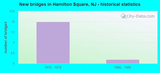
- New bridges - historical statistics
- 101970-1979
- 11980-1989


- Bridge Condition - Deck
- 66.7%Good
- 16.7%Satisfactory
- 16.7%Fair

- Bridge Condition - Superstructure
- 16.7%Very good
- 66.7%Good
- 16.7%Fair

- Bridge Condition - Substructure
- 50.0%Good
- 50.0%Satisfactory

- Bridge Condition - Channel
- 50.0%Very good
- 50.0%Fair
Find on map >> Show street view
Structure Number: 1106417, Location: 1.26 MI.N.OF COUNTY RT533 (Lat: 40.247169, Lng: -74.668731), Route carried "on" structure: County highway 535, Year Built: 1971, Status: Open, Structure Length: 1.46m (4.79ft), Average Daily Traffic: 7,460 (year 2021), Truck Traffic: 4%, Average Future Daily Traffic: 9,100 (year 2041), Design Load: HS 20+Mod, Features Intersected: MIRY RUN
Minimum Vertical Clearance: 30+ m (98+ ft), Kilometerpoint: 7.564, Lanes on structure: 4, Owner: County Highway Agency, Approaching Roadway Width: 16.5m (54.1ft), Material/Design: Prestressed concrete, Design/Construction: Box Beam or Girders - Multiple, Number Of Spans In Main Unit: 1, Length of Maximum Span: 14.3m (46.9ft), Curb or Sidewalk Widths: Left: 2.6m (8.5ft), Right: 2.6m (8.5ft), Curb-To-Curb Width: 16.5m (54.1ft), Out-to-Out Width: 23.8m (78.1ft)
Condition: Deck: Fair, Superstructure: Fair, Substructure: Satisfactory, Channel: Fair, Operating Rating: 29.9 metric tons, Method Used To Determine Operating Rating: Load Factor (LF), Inventory Rating: 16.3 metric tons, Method Used To Determine Inventory Rating: Load Factor (LF), Structural Evaluation: Meets minimum limits, Deck Geometry: Meets minimum limits, Waterway Adequacy: Better than present minimum criteria, Approach Roadway Alignment: Equal to present desirable criteria, Designated Inspection Frequency: Every 24 months, Inspection Date: March 2021, Deck Structure Type: Concrete Precast Panels, Wearing Surface/Protective System: Wearing Surface: Bituminous
Find on map >> Show street view
Structure Number: 1109411, Location: 1.0 MI WEST OF CO. 535 (Lat: 40.240011, Lng: -74.639589), Route carried "on" structure: City street , Year Built: 1988, Status: Open, Structure Length: 1.95m (6.40ft), Average Daily Traffic: 896 (year 2021), Truck Traffic: 3%, Average Future Daily Traffic: 1,075 (year 2041), Design Load: HS 20, Features Intersected: MIRY RUN, Facility Carried by Structure: COMBS ROAD
Minimum Vertical Clearance: 30+ m (98+ ft), Kilometerpoint: 2.237, Lanes on structure: 2, Owner: County Highway Agency, Approaching Roadway Width: 11.0m (36.1ft), Material/Design: Concrete, Design/Construction: Culvert, Number Of Spans In Main Unit: 3, Length of Maximum Span: 6.1m (20.0ft), Curb or Sidewalk Widths: Left: 0.3m (1.0ft), Right: 0.3m (1.0ft), Curb-To-Curb Width: 11.0m (36.1ft), Out-to-Out Width: 24.4m (80.1ft)
Condition: Channel: Very good, Culverts: Good, Operating Rating: 81.6 metric tons, Method Used To Determine Operating Rating: Load Factor (LF), Inventory Rating: 49.0 metric tons, Method Used To Determine Inventory Rating: Load Factor (LF), Structural Evaluation: Better than present minimum criteria, Deck Geometry: Better than present minimum criteria, Waterway Adequacy: Better than present minimum criteria, Approach Roadway Alignment: Equal to present desirable criteria, Designated Inspection Frequency: Every 24 months, Inspection Date: Febuary 2021
Find on map >> Show street view
Structure Number: 1134158, Location: 0.8 MI WEST OF US 130 JCT (Lat: 40.202200, Lng: -74.650689), Route carried "on" structure: Interstate 195, Year Built: 1973, Status: Open, Structure Length: 3.23m (10.60ft), Average Daily Traffic: 36,283 (year 2021), Truck Traffic: 9%, Average Future Daily Traffic: 43,724 (year 2041), Design Load: HS 20, Features Intersected: KLOCKNER ROAD
Minimum Vertical Clearance: 30+ m (98+ ft), Kilometerpoint: 6.614, Lanes on structure: 2, Lanes under structure: 4, Base Highway Network: Yes, Owner: State Highway Agency, Approaching Roadway Width: 12.8m (42.0ft), Skew: 1 degrees, Material/Design: Steel, Design/Construction: Stringer/Multi-beam, Number Of Spans In Main Unit: 1, Length of Maximum Span: 31.1m (102.0ft), Curb-To-Curb Width: 13.0m (42.7ft), Out-to-Out Width: 14.2m (46.6ft)
Condition: Deck: Good, Superstructure: Very good, Substructure: Satisfactory, Operating Rating: 89.8 metric tons, Method Used To Determine Operating Rating: Load Factor (LF), Inventory Rating: 53.5 metric tons, Method Used To Determine Inventory Rating: Load Factor (LF), Structural Evaluation: Equal to present minimum criteria, Deck Geometry: Superior to present desirable criteria, Underclear: Meets minimum limits, Approach Roadway Alignment: Equal to present desirable criteria, Designated Inspection Frequency: Every 24 months, Inspection Date: April 2021, Deck Structure Type: Concrete Cast-file-Place, Wearing Surface/Protective System: Wearing Surface: Monolithic Concrete
Find on map >> Show street view
Structure Number: 1134159, Location: 0.8MI WEST OF US130 (Lat: 40.202669, Lng: -74.650019), Route carried "on" structure: Interstate 195, Year Built: 1973, Status: Open, Structure Length: 3.23m (10.60ft), Average Daily Traffic: 37,368 (year 2021), Truck Traffic: 9%, Average Future Daily Traffic: 45,597 (year 2041), Design Load: HS 20, Features Intersected: KLOCKNER ROAD
Minimum Vertical Clearance: 30+ m (98+ ft), Kilometerpoint: 6.614, Lanes on structure: 2, Lanes under structure: 4, Base Highway Network: Yes, Owner: State Highway Agency, Approaching Roadway Width: 12.8m (42.0ft), Skew: 1 degrees, Material/Design: Steel, Design/Construction: Stringer/Multi-beam, Number Of Spans In Main Unit: 1, Length of Maximum Span: 31.1m (102.0ft), Curb or Sidewalk Widths: Left: 0.2m (0.7ft), Right: 0.2m (0.7ft), Curb-To-Curb Width: 13.0m (42.7ft), Out-to-Out Width: 14.2m (46.6ft)
Condition: Deck: Good, Superstructure: Good, Substructure: Satisfactory, Inventory Rating: 53.5 metric tons, Method Used To Determine Inventory Rating: Load Factor (LF), Structural Evaluation: Equal to present minimum criteria, Deck Geometry: Superior to present desirable criteria, Underclear: Meets minimum limits, Approach Roadway Alignment: Equal to present desirable criteria, Designated Inspection Frequency: Every 24 months, Inspection Date: April 2021, Deck Structure Type: Concrete Cast-file-Place, Wearing Surface/Protective System: Wearing Surface: Monolithic Concrete, Deck Protection: Epoxy Coated Reinforcing
Find on map >> Show street view
Structure Number: 1134161, Location: 0.65 mi W of US 130 (Lat: 40.203269, Lng: -74.646831), Route carried "on" structure: Interstate 195, Year Built: 1973, Status: Open, Structure Length: 5.91m (19.39ft), Average Daily Traffic: 37,380 (year 2021), Truck Traffic: 9%, Average Future Daily Traffic: 44,260 (year 2041), Design Load: HS 20, Features Intersected: CONRAIL (Abandoned)
Minimum Vertical Clearance: 30+ m (98+ ft), Kilometerpoint: 6.840, Lanes on structure: 2, Base Highway Network: Yes, Owner: State Highway Agency, Approaching Roadway Width: 12.8m (42.0ft), Skew: 5 degrees, Material/Design: Steel, Design/Construction: Stringer/Multi-beam, Number Of Spans In Main Unit: 3, Length of Maximum Span: 22.3m (73.2ft), Curb or Sidewalk Widths: Left: 0.2m (0.7ft), Right: 0.2m (0.7ft), Curb-To-Curb Width: 13.0m (42.7ft), Out-to-Out Width: 14.2m (46.6ft)
Condition: Deck: Good, Superstructure: Good, Substructure: Good, Operating Rating: 88.0 metric tons, Method Used To Determine Operating Rating: Load Factor (LF), Inventory Rating: 52.6 metric tons, Method Used To Determine Inventory Rating: Load Factor (LF), Structural Evaluation: Better than present minimum criteria, Deck Geometry: Superior to present desirable criteria, Approach Roadway Alignment: Better than present minimum criteria, Designated Inspection Frequency: Every 24 months, Inspection Date: April 2021, Deck Structure Type: Concrete Cast-file-Place, Wearing Surface/Protective System: Wearing Surface: Monolithic Concrete
Find on map >> Show street view
Structure Number: 1134163, Location: JCT US 130 (Lat: 40.202239, Lng: -74.635781), Route carried "on" structure: Interstate 195, Year Built: 1972, Status: Open, Structure Length: 6.34m (20.80ft), Average Daily Traffic: 71,900 (year 2020), Truck Traffic: 9%, Average Future Daily Traffic: 85,163 (year 2040), Design Load: HS 20+Mod, Features Intersected: US 130
Minimum Vertical Clearance: 30+ m (98+ ft), Kilometerpoint: 7.886, Lanes on structure: 3, Lanes under structure: 6, Base Highway Network: Yes, Owner: State Highway Agency, Approaching Roadway Width: 15.8m (51.8ft), Skew: 2 degrees, Material/Design: Steel, Design/Construction: Stringer/Multi-beam, Number Of Spans In Main Unit: 2, Length of Maximum Span: 30.8m (101.0ft), Curb or Sidewalk Widths: Left: 0.2m (0.7ft), Right: 0.2m (0.7ft), Curb-To-Curb Width: 15.8m (51.8ft), Out-to-Out Width: 17.1m (56.1ft)
Condition: Deck: Good, Superstructure: Good, Substructure: Good, Operating Rating: 68.0 metric tons, Method Used To Determine Operating Rating: Load Factor (LF), Inventory Rating: 40.8 metric tons, Method Used To Determine Inventory Rating: Load Factor (LF), Structural Evaluation: Better than present minimum criteria, Deck Geometry: Somewhat better than minimum adequacy, Underclear: Better than present minimum criteria, Approach Roadway Alignment: Equal to present desirable criteria, Designated Inspection Frequency: Every 24 months, Inspection Date: June 2020, Deck Structure Type: Concrete Cast-file-Place
Find on map >> Show street view
Structure Number: 1134164, Location: 1.9 MI WEST OF NJTPK JCT (Lat: 40.202181, Lng: -74.635300), Route carried "on" structure: Interstate 195, Year Built: 1972, Status: Open, Structure Length: 6.34m (20.80ft), Average Daily Traffic: 71,903 (year 2020), Truck Traffic: 9%, Average Future Daily Traffic: 86,283 (year 2040), Design Load: HS 20+Mod, Features Intersected: US 130
Minimum Vertical Clearance: 30+ m (98+ ft), Kilometerpoint: 7.918, Lanes on structure: 3, Lanes under structure: 6, Base Highway Network: Yes, Owner: State Highway Agency, Approaching Roadway Width: 15.8m (51.8ft), Skew: 2 degrees, Material/Design: Steel, Design/Construction: Stringer/Multi-beam, Number Of Spans In Main Unit: 2, Length of Maximum Span: 30.8m (101.0ft), Curb-To-Curb Width: 15.8m (51.8ft), Out-to-Out Width: 17.1m (56.1ft)
Condition: Deck: Satisfactory, Superstructure: Good, Substructure: Good, Operating Rating: 59.9 metric tons, Method Used To Determine Operating Rating: Load Factor (LF), Inventory Rating: 35.4 metric tons, Method Used To Determine Inventory Rating: Load Factor (LF), Structural Evaluation: Better than present minimum criteria, Deck Geometry: Somewhat better than minimum adequacy, Underclear: Equal to present minimum criteria, Approach Roadway Alignment: Equal to present desirable criteria, Designated Inspection Frequency: Every 24 months, Inspection Date: June 2020, Deck Structure Type: Concrete Cast-file-Place, Wearing Surface/Protective System: Wearing Surface: Latex Concrete
Find on map >> Show street view
Structure Number: 1134158, Location: 0.8 MI WEST OF US 130 JCT (Lat: 40.202200, Lng: -74.650689), Route carried "under" structure: City street , Year Built: 1973, Structure Length: 0. m, Average Daily Traffic: 3,977 (year 2021), Truck Traffic: 3%, Features Intersected: KLOCKNER ROAD, Facility Carried by Structure: I-195 EB
Minimum Vertical Clearance: 4.97m (16.31ft), Kilometerpoint: 0.386, Lanes on structure: 2, Lanes under structure: 4, Material/Design: Steel, Design/Construction: Stringer/Multi-beam, Length of Maximum Span: 31.1m (102.0ft)
Find on map >> Show street view
Structure Number: 1134159, Location: 0.8MI WEST OF US130 (Lat: 40.202669, Lng: -74.650019), Route carried "under" structure: County highway , Year Built: 1973, Structure Length: 0. m, Average Daily Traffic: 4,015 (year 2021), Truck Traffic: 3%, Features Intersected: KLOCKNER ROAD, Facility Carried by Structure: I-195 WB
Minimum Vertical Clearance: 4.75m (15.58ft), Kilometerpoint: 0.386, Lanes on structure: 2, Lanes under structure: 4, Material/Design: Steel, Design/Construction: Stringer/Multi-beam, Length of Maximum Span: 31.1m (102.0ft)
Find on map >> Show street view
Structure Number: 1134163, Location: JCT US 130 (Lat: 40.202239, Lng: -74.635781), Route carried "under" structure: US 130, Year Built: 1972, Structure Length: 0. m, Average Daily Traffic: 32,750 (year 2020), Truck Traffic: 4%, Features Intersected: US 130, Facility Carried by Structure: I-195 EB
Minimum Vertical Clearance: 5.18m (16.99ft), Kilometerpoint: 98.765, Lanes on structure: 3, Lanes under structure: 6, Material/Design: Steel, Design/Construction: Stringer/Multi-beam, Length of Maximum Span: 30.8m (101.0ft)
Find on map >> Show street view
Structure Number: 1134164, Location: 1.9 MI WEST OF NJTPK JCT (Lat: 40.202181, Lng: -74.635300), Route carried "under" structure: US 130, Year Built: 1972, Structure Length: 0. m, Average Daily Traffic: 39,565 (year 2020), Truck Traffic: 4%, Features Intersected: US 130, Facility Carried by Structure: I-195 WB
Minimum Vertical Clearance: 4.67m (15.32ft), Kilometerpoint: 98.765, Lanes on structure: 3, Lanes under structure: 6, Material/Design: Steel, Design/Construction: Stringer/Multi-beam, Length of Maximum Span: 30.8m (101.0ft)