Bridge Statistics for Haddonfield, New Jersey (NJ)
Condition, Traffic, Stress, Structural Evaluation, Project Costs
- National Bridge Inventory (NBI) Statistics
- 24Number of bridges
- 180ft / 55.3mTotal length
- $1,972,000Total costs
- 534,685Total average daily traffic
- 50,231Total average daily truck traffic
- National Bridge Inventory (NBI) Registered Bridges for Haddonfield
- No street view available for this location
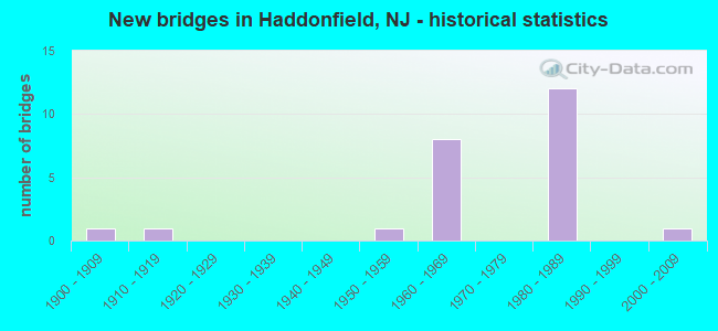
- New bridges - historical statistics
- 11900-1909
- 11910-1919
- 11950-1959
- 81960-1969
- 121980-1989
- 12000-2009

- Reconstructed bridges - Historical Statistics
- 11960-1969
- 21970-1979


- Bridge Condition - Deck
- 7.1%Very good
- 21.4%Good
- 57.1%Satisfactory
- 7.1%Fair
- 7.1%Poor

- Bridge Condition - Superstructure
- 6.7%Very good
- 13.3%Good
- 53.3%Satisfactory
- 26.7%Fair

- Bridge Condition - Substructure
- 6.7%Very good
- 6.7%Good
- 80.0%Satisfactory
- 6.7%Fair

- Bridge Condition - Channel
- 14.3%Good
- 42.9%Satisfactory
- 42.9%Fair

- Bridge Condition - Culverts
- 33.3%Good
- 33.3%Satisfactory
- 33.3%Fair
Find on map >> Show street view
Structure Number: 404152, Location: 1.2 MI NE OF RT 30 (Lat: 39.897711, Lng: -75.048611), Route carried "on" structure: City street , Year Built: 1965, Status: Open, Structure Length: 0.82m (2.69ft), Average Daily Traffic: 520 (year 2019), Truck Traffic: 1%, Average Future Daily Traffic: 624 (year 2039), Design Load: HS 20, Features Intersected: Main Branch Newton Creek, Facility Carried by Structure: Graisbury Ave
Minimum Vertical Clearance: 30+ m (98+ ft), Kilometerpoint: 1.127, Lanes on structure: 2, Owner: County Highway Agency, Maintenance Responsibility: Town or Township Highway Agency, Approaching Roadway Width: 8.8m (28.9ft), Skew: 5 degrees, Material/Design: Aluminum, Iron, Design/Construction: Culvert, Number Of Spans In Main Unit: 4, Length of Maximum Span: 1.2m (3.9ft), Curb or Sidewalk Widths: Left: 0.0m, Right: 1.7m (5.6ft)
Condition: Channel: Fair, Culverts: Fair, Operating Rating: 50.8 metric tons, Method Used To Determine Operating Rating: Field evaluation and documented engineering judgment, Inventory Rating: 30.8 metric tons, Method Used To Determine Inventory Rating: Field evaluation and documented engineering judgment, Structural Evaluation: Somewhat better than minimum adequacy, Waterway Adequacy: Better than present minimum criteria, Approach Roadway Alignment: Equal to present desirable criteria, Designated Inspection Frequency: Every 24 months, Inspection Date: March 2021
Find on map >> Show street view
Structure Number: 429152, Location: 3.2 MI SOUTH OF RT 70 (Lat: 39.875050, Lng: -75.017569), Route carried "on" structure: Interstate 295, Year Built: 1962, Year Reconstructed: 1982, Status: Open, Structure Length: 1.28m (4.20ft), Average Daily Traffic: 145,003 (year 2020), Truck Traffic: 9%, Average Future Daily Traffic: 176,931 (year 2040), Design Load: HS 20, Features Intersected: COOPER RIVER
Minimum Vertical Clearance: 30.45m (99.90ft), Kilometerpoint: 51.193, Lanes on structure: 8, Base Highway Network: Yes, Owner: State Highway Agency, Approaching Roadway Width: 39.0m (128.0ft), Skew: 21 degrees, Material/Design: Concrete, Design/Construction: Culvert, Number Of Spans In Main Unit: 2, Length of Maximum Span: 6.1m (20.0ft)
Condition: Channel: Satisfactory, Culverts: Good, Structural Evaluation: Better than present minimum criteria, Waterway Adequacy: Equal to present desirable criteria, Approach Roadway Alignment: Equal to present desirable criteria, Designated Inspection Frequency: Every 24 months, Inspection Date: Febuary 2020
Find on map >> Show street view
Structure Number: 429163, Location: .66 MILES SOUTH OF RT 561 (Lat: 39.872261, Lng: -75.017039), Route carried "on" structure: Ramp Interstate 295, Year Built: 1982, Status: Open, Structure Length: 9.20m (30.18ft), Average Daily Traffic: 8,511 (year 2020), Truck Traffic: 9%, Average Future Daily Traffic: 10,315 (year 2040), Design Load: HS 20+Mod, Features Intersected: COOPER RIVER
Minimum Vertical Clearance: 30+ m (98+ ft), Kilometerpoint: 51.081, Lanes on structure: 4, Owner: State Highway Agency, Approaching Roadway Width: 18.0m (59.1ft), Material/Design: Steel, Design/Construction: Stringer/Multi-beam, Number Of Spans In Main Unit: 4, Length of Maximum Span: 22.3m (73.2ft), Curb-To-Curb Width: 17.8m (58.4ft), Out-to-Out Width: 18.8m (61.7ft)
Condition: Deck: Good, Superstructure: Good, Substructure: Satisfactory, Channel: Fair, Operating Rating: 74.4 metric tons, Method Used To Determine Operating Rating: Load Factor (LF), Inventory Rating: 44.5 metric tons, Method Used To Determine Inventory Rating: Load Factor (LF), Structural Evaluation: Equal to present minimum criteria, Deck Geometry: Better than present minimum criteria, Waterway Adequacy: Superior to present desirable criteria, Approach Roadway Alignment: Equal to present desirable criteria, Designated Inspection Frequency: Every 24 months, Critical Feature Inspection Frequency: Every 24 months, Inspection Date: August 2020, Critical Feature Inspection Date: August 2020, Deck Structure Type: Concrete Cast-file-Place, Wearing Surface/Protective System: Wearing Surface: Monolithic Concrete, Deck Protection: Epoxy Coated Reinforcing
Find on map >> Show street view
Structure Number: 429164, Location: 0.8 MILES SOUTH ROUTE 561 (Lat: 37.875661, Lng: -75.017331), Route carried "on" structure: Ramp Interstate 295, Year Built: 1981, Status: Open, Structure Length: 1.40m (4.59ft), Average Daily Traffic: 4,899 (year 2020), Truck Traffic: 9%, Average Future Daily Traffic: 5,878 (year 2040), Design Load: HS 20+Mod, Features Intersected: COOPER RIVER
Minimum Vertical Clearance: 30.45m (99.90ft), Kilometerpoint: 51.193, Lanes on structure: 2, Owner: State Highway Agency, Approaching Roadway Width: 17.1m (56.1ft), Skew: 30 degrees, Material/Design: Concrete, Design/Construction: Culvert, Number Of Spans In Main Unit: 2, Length of Maximum Span: 6.7m (22.0ft)
Condition: Channel: Satisfactory, Culverts: Satisfactory, Structural Evaluation: Equal to present minimum criteria, Waterway Adequacy: Better than present minimum criteria, Approach Roadway Alignment: Somewhat better than minimum adequacy, Designated Inspection Frequency: Every 24 months, Inspection Date: March 2020
Find on map >> Show street view
Structure Number: 429165, Location: .7 MI SOUTH OF RT 561 (Lat: 39.873769, Lng: -75.018250), Route carried "on" structure: Interstate 295, Year Built: 1982, Status: Open, Structure Length: 4.82m (15.81ft), Average Daily Traffic: 73,225 (year 2020), Truck Traffic: 9%, Average Future Daily Traffic: 87,870 (year 2040), Design Load: HS 20+Mod, Features Intersected: I-295 RAMPS A & B
Minimum Vertical Clearance: 30+ m (98+ ft), Kilometerpoint: 51.081, Lanes on structure: 3, Lanes under structure: 2, Base Highway Network: Yes, Owner: State Highway Agency, Approaching Roadway Width: 19.8m (65.0ft), Skew: 1 degrees, Material/Design: Steel, Design/Construction: Stringer/Multi-beam, Number Of Spans In Main Unit: 2, Length of Maximum Span: 24.1m (79.1ft), Curb-To-Curb Width: 19.8m (65.0ft), Out-to-Out Width: 21.9m (71.9ft)
Condition: Deck: Good, Superstructure: Satisfactory, Substructure: Satisfactory, Inventory Rating: 64.4 metric tons, Method Used To Determine Inventory Rating: Load Factor (LF), Structural Evaluation: Equal to present minimum criteria, Deck Geometry: Superior to present desirable criteria, Underclear: Somewhat better than minimum adequacy, Approach Roadway Alignment: Equal to present desirable criteria, Designated Inspection Frequency: Every 24 months, Inspection Date: Febuary 2020, Deck Structure Type: Concrete Cast-file-Place, Wearing Surface/Protective System: Wearing Surface: Monolithic Concrete, Deck Protection: Epoxy Coated Reinforcing
Find on map >> Show street view
Structure Number: 429166, Location: .7 MILES SOUTH OF RT 561 (Lat: 39.874361, Lng: -75.017911), Route carried "on" structure: Interstate 295, Year Built: 1982, Status: Open, Structure Length: 4.88m (16.01ft), Average Daily Traffic: 68,836 (year 2020), Truck Traffic: 9%, Average Future Daily Traffic: 82,604 (year 2040), Design Load: HS 20+Mod, Features Intersected: I-295 RAMPS A&B
Minimum Vertical Clearance: 30+ m (98+ ft), Kilometerpoint: 51.081, Lanes on structure: 4, Lanes under structure: 2, Base Highway Network: Yes, Owner: State Highway Agency, Approaching Roadway Width: 23.5m (77.1ft), Skew: 1 degrees, Material/Design: Steel, Design/Construction: Stringer/Multi-beam, Number Of Spans In Main Unit: 2, Length of Maximum Span: 24.1m (79.1ft), Curb-To-Curb Width: 25.0m (82.0ft), Out-to-Out Width: 25.6m (84.0ft)
Condition: Deck: Good, Superstructure: Good, Substructure: Satisfactory, Operating Rating: 70.8 metric tons, Method Used To Determine Operating Rating: Load Factor (LF), Inventory Rating: 42.6 metric tons, Method Used To Determine Inventory Rating: Load Factor (LF), Structural Evaluation: Equal to present minimum criteria, Deck Geometry: Superior to present desirable criteria, Underclear: Somewhat better than minimum adequacy, Approach Roadway Alignment: Equal to present desirable criteria, Designated Inspection Frequency: Every 24 months, Inspection Date: June 2020, Deck Structure Type: Concrete Cast-file-Place, Wearing Surface/Protective System: Wearing Surface: Monolithic Concrete, Deck Protection: Epoxy Coated Reinforcing
Find on map >> Show street view
Structure Number: 44D006, Location: 0.48 MI N OF NJ154 JCT (Lat: 39.895050, Lng: -75.024250), Route carried "on" structure: County highway 561, Year Built: 1980, Status: Open, Structure Length: 2.07m (6.79ft), Average Daily Traffic: 12,780 (year 2021), Truck Traffic: 4%, Average Future Daily Traffic: 15,336 (year 2041), Design Load: HS 20, Features Intersected: COOPER RIVER
Minimum Vertical Clearance: 30+ m (98+ ft), Kilometerpoint: 72.131, Lanes on structure: 4, Base Highway Network: Yes, Owner: County Highway Agency, Approaching Roadway Width: 15.2m (49.9ft), Skew: 20 degrees, Material/Design: Prestressed concrete, Design/Construction: Box Beam or Girders - Multiple, Number Of Spans In Main Unit: 1, Length of Maximum Span: 20.1m (65.9ft), Curb or Sidewalk Widths: Left: 1.5m (4.9ft), Right: 1.5m (4.9ft), Curb-To-Curb Width: 15.4m (50.5ft), Out-to-Out Width: 20.8m (68.2ft)
Condition: Deck: Satisfactory, Superstructure: Satisfactory, Substructure: Good, Channel: Satisfactory, Operating Rating: 54.4 metric tons, Method Used To Determine Operating Rating: Load Factor (LF), Inventory Rating: 32.7 metric tons, Method Used To Determine Inventory Rating: Load Factor (LF), Structural Evaluation: Equal to present minimum criteria, Deck Geometry: Meets minimum limits, Waterway Adequacy: Equal to present minimum criteria, Approach Roadway Alignment: Meets minimum limits, Designated Inspection Frequency: Every 24 months, Inspection Date: March 2021, Deck Structure Type: Concrete Cast-file-Place, Wearing Surface/Protective System: Wearing Surface: Bituminous
Find on map >> Show street view
Structure Number: 44D009, Location: 1.09 MI S OF RT 70 JCT (Lat: 39.903369, Lng: -75.022181), Route carried "on" structure: County highway 41, Year Built: 1915, Status: Open, Structure Length: 1.46m (4.79ft), Average Daily Traffic: 10,486 (year 2021), Truck Traffic: 4%, Average Future Daily Traffic: 12,584 (year 2041), Design Load: H 20, Features Intersected: COOPER RIVER
Minimum Vertical Clearance: 30+ m (98+ ft), Kilometerpoint: 15.691, Lanes on structure: 2, Owner: County Highway Agency, Approaching Roadway Width: 14.0m (45.9ft), Material/Design: Concrete, Design/Construction: Arch - Deck, Number Of Spans In Main Unit: 1, Length of Maximum Span: 9.8m (32.2ft), Curb or Sidewalk Widths: Left: 1.8m (5.9ft), Right: 1.8m (5.9ft), Curb-To-Curb Width: 14.2m (46.6ft), Out-to-Out Width: 18.4m (60.4ft)
Condition: Superstructure: Fair, Substructure: Satisfactory, Channel: Fair, Structural Evaluation: Somewhat better than minimum adequacy, Deck Geometry: Superior to present desirable criteria, Waterway Adequacy: Superior to present desirable criteria, Approach Roadway Alignment: Better than present minimum criteria, Designated Inspection Frequency: Every 24 months, Inspection Date: March 2021, Wearing Surface/Protective System: Wearing Surface: Bituminous
Find on map >> Show street view
Structure Number: 45916, Location: 0.05 mi South of CR 561 (Lat: 39.901739, Lng: -75.039389), Route carried "on" structure: City street 9045, Year Built: 1969, Status: Open, Structure Length: 1.71m (5.61ft), Average Daily Traffic: 2,000 (year 2020), Truck Traffic: 1%, Average Future Daily Traffic: 2,400 (year 2040), Design Load: H 20, Features Intersected: DRPA/PATCO RR & NJT RR, Facility Carried by Structure: MT VERNON AVE
Minimum Vertical Clearance: 30+ m (98+ ft), Kilometerpoint: 14.613, Lanes on structure: 2, Owner: State Toll Authority, Maintenance Responsibility: Railroad, Approaching Roadway Width: 9.1m (29.9ft), Skew: 7 degrees, Material/Design: Steel, Design/Construction: Stringer/Multi-beam, Number Of Spans In Main Unit: 1, Length of Maximum Span: 16.2m (53.1ft), Curb or Sidewalk Widths: Left: 1.5m (4.9ft), Right: 1.5m (4.9ft), Curb-To-Curb Width: 9.1m (29.9ft), Out-to-Out Width: 12.8m (42.0ft)
Condition: Deck: Satisfactory, Superstructure: Satisfactory, Substructure: Satisfactory, Operating Rating: 89.8 metric tons, Method Used To Determine Operating Rating: Load and Resistance Factor (LRFR), Inventory Rating: 89.8 metric tons, Method Used To Determine Inventory Rating: Load and Resistance Factor (LRFR), Structural Evaluation: Equal to present minimum criteria, Deck Geometry: Somewhat better than minimum adequacy, Underclear: High priority of corrective action, Approach Roadway Alignment: Better than present minimum criteria, Designated Inspection Frequency: Every 24 months, Inspection Date: June 2020, Roadway Improvement Cost: $1,000, Total Project Cost: $12,000 ( Estimate for 2018), Deck Structure Type: Concrete Cast-file-Place, Wearing Surface/Protective System: Wearing Surface: Monolithic Concrete
Find on map >> Show street view
Structure Number: 459161, Location: 0.1 mi South of CR 561 (Lat: 39.900731, Lng: -75.038600), Route carried "on" structure: City street 9045, Year Built: 1969, Status: Open, Structure Length: 1.77m (5.81ft), Average Daily Traffic: 2,000 (year 2020), Truck Traffic: 1%, Average Future Daily Traffic: 2,400 (year 2040), Design Load: H 20, Features Intersected: DRPA/PATCO RR & NJT RR, Facility Carried by Structure: REDMAN AVE
Minimum Vertical Clearance: 30+ m (98+ ft), Kilometerpoint: 14.758, Lanes on structure: 2, Owner: State Toll Authority, Maintenance Responsibility: Railroad, Approaching Roadway Width: 9.1m (29.9ft), Skew: 7 degrees, Material/Design: Steel, Design/Construction: Stringer/Multi-beam, Number Of Spans In Main Unit: 1, Length of Maximum Span: 16.8m (55.1ft), Curb or Sidewalk Widths: Left: 1.5m (4.9ft), Right: 1.5m (4.9ft), Curb-To-Curb Width: 9.1m (29.9ft), Out-to-Out Width: 12.8m (42.0ft)
Condition: Deck: Satisfactory, Superstructure: Satisfactory, Substructure: Satisfactory, Operating Rating: 89.8 metric tons, Method Used To Determine Operating Rating: Load and Resistance Factor (LRFR), Inventory Rating: 89.8 metric tons, Method Used To Determine Inventory Rating: Load and Resistance Factor (LRFR), Structural Evaluation: Equal to present minimum criteria, Deck Geometry: Somewhat better than minimum adequacy, Underclear: High priority of corrective action, Approach Roadway Alignment: Better than present minimum criteria, Designated Inspection Frequency: Every 24 months, Inspection Date: June 2020, Roadway Improvement Cost: $2,000, Total Project Cost: $2,000 ( Estimate for 2018), Deck Structure Type: Concrete Cast-file-Place, Wearing Surface/Protective System: Wearing Surface: Monolithic Concrete
Find on map >> Show street view
Structure Number: 459162, Location: 0.15 mi South of CR 561 (Lat: 39.898961, Lng: -75.037581), Route carried "on" structure: City street 9045, Year Built: 1969, Status: Open, Structure Length: 1.83m (6.00ft), Average Daily Traffic: 2,000 (year 2020), Truck Traffic: 1%, Average Future Daily Traffic: 2,400 (year 2040), Design Load: H 20, Features Intersected: DRPA/PATCO RR & NJT RR, Facility Carried by Structure: EUCLID AVENUE
Minimum Vertical Clearance: 30+ m (98+ ft), Kilometerpoint: 14.951, Lanes on structure: 2, Owner: State Toll Authority, Maintenance Responsibility: Railroad, Approaching Roadway Width: 11.0m (36.1ft), Skew: 6 degrees, Material/Design: Steel, Design/Construction: Stringer/Multi-beam, Number Of Spans In Main Unit: 1, Length of Maximum Span: 18.3m (60.0ft), Curb or Sidewalk Widths: Left: 2.4m (7.9ft), Right: 2.4m (7.9ft), Curb-To-Curb Width: 11.0m (36.1ft), Out-to-Out Width: 16.4m (53.8ft)
Condition: Deck: Poor, Superstructure: Fair, Substructure: Satisfactory, Operating Rating: 89.8 metric tons, Method Used To Determine Operating Rating: Load and Resistance Factor (LRFR), Inventory Rating: 89.8 metric tons, Method Used To Determine Inventory Rating: Load and Resistance Factor (LRFR), Structural Evaluation: Somewhat better than minimum adequacy, Deck Geometry: Equal to present minimum criteria, Underclear: High priority of corrective action, Approach Roadway Alignment: Equal to present desirable criteria, Designated Inspection Frequency: Every 24 months, Inspection Date: June 2020, Roadway Improvement Cost: $10,000, Total Project Cost: $26,000 ( Estimate for 2018), Deck Structure Type: Concrete Cast-file-Place, Wearing Surface/Protective System: Wearing Surface: Monolithic Concrete
Find on map >> Show street view
Structure Number: 459163, Location: 0.1 mi West of NJ 41 (Lat: 39.896781, Lng: -75.036281), Route carried "on" structure: ServiceOther road 9045, Year Built: 1969, Status: Open, Structure Length: 2.10m (6.89ft), Average Daily Traffic: 1,392 (year 2020), Truck Traffic: 1%, Average Future Daily Traffic: 1,670 (year 2040), Design Load: H 20, Features Intersected: DRPA/PATCO RR & NJT RR, Facility Carried by Structure: Haddonfield Park'g
Minimum Vertical Clearance: 30+ m (98+ ft), Kilometerpoint: 15.128, Lanes on structure: 2, Owner: State Toll Authority, Maintenance Responsibility: Railroad, Approaching Roadway Width: 9.1m (29.9ft), Skew: 1 degrees, Material/Design: Steel, Design/Construction: Stringer/Multi-beam, Number Of Spans In Main Unit: 1, Length of Maximum Span: 21.0m (68.9ft), Curb or Sidewalk Widths: Left: 1.8m (5.9ft), Right: 1.8m (5.9ft), Curb-To-Curb Width: 9.2m (30.2ft), Out-to-Out Width: 13.5m (44.3ft)
Condition: Deck: Satisfactory, Superstructure: Satisfactory, Substructure: Satisfactory, Operating Rating: 89.8 metric tons, Method Used To Determine Operating Rating: Load and Resistance Factor (LRFR), Inventory Rating: 89.8 metric tons, Method Used To Determine Inventory Rating: Load and Resistance Factor (LRFR), Structural Evaluation: Equal to present minimum criteria, Deck Geometry: Somewhat better than minimum adequacy, Underclear: High priority of corrective action, Approach Roadway Alignment: Meets minimum limits, Designated Inspection Frequency: Every 24 months, Inspection Date: June 2020, Bridge Improvement Cost: $1,000, Roadway Improvement Cost: $1,000, Total Project Cost: $2,000 ( Estimate for 2018), Deck Structure Type: Concrete Cast-file-Place, Wearing Surface/Protective System: Wearing Surface: Bituminous
Find on map >> Show street view
Structure Number: 459164, Location: 0.1 mi North of Warwick R (Lat: 39.896200, Lng: -75.035919), Route carried "on" structure: State highway 9045, Year Built: 1969, Status: Open, Structure Length: 1.80m (5.91ft), Average Daily Traffic: 12,434 (year 2020), Truck Traffic: 1%, Average Future Daily Traffic: 14,921 (year 2040), Design Load: H 20, Features Intersected: DRPA/PATCO RR & NJT RR, Facility Carried by Structure: KINGS HWY (NJ 41)
Minimum Vertical Clearance: 30+ m (98+ ft), Kilometerpoint: 14.227, Lanes on structure: 2, Base Highway Network: Yes, Owner: State Toll Authority, Maintenance Responsibility: Railroad, Approaching Roadway Width: 12.8m (42.0ft), Skew: 1 degrees, Material/Design: Steel, Design/Construction: Stringer/Multi-beam, Number Of Spans In Main Unit: 1, Length of Maximum Span: 18.0m (59.1ft), Curb or Sidewalk Widths: Left: 3.7m (12.1ft), Right: 3.0m (9.8ft), Curb-To-Curb Width: 14.6m (47.9ft), Out-to-Out Width: 21.9m (71.9ft)
Condition: Deck: Fair, Superstructure: Satisfactory, Substructure: Satisfactory, Operating Rating: 89.8 metric tons, Method Used To Determine Operating Rating: Load and Resistance Factor (LRFR), Inventory Rating: 89.8 metric tons, Method Used To Determine Inventory Rating: Load and Resistance Factor (LRFR), Structural Evaluation: Equal to present minimum criteria, Deck Geometry: Superior to present desirable criteria, Underclear: High priority of corrective action, Approach Roadway Alignment: Equal to present minimum criteria, Designated Inspection Frequency: Every 24 months, Inspection Date: June 2020, Roadway Improvement Cost: $128,000, Total Project Cost: $128,000 ( Estimate for 2018), Deck Structure Type: Concrete Cast-file-Place, Wearing Surface/Protective System: Wearing Surface: Monolithic Concrete
Find on map >> Show street view
Structure Number: 459165, Location: 0.1 mi East of NJ 41 (Lat: 39.894231, Lng: -75.034889), Route carried "on" structure: City street 9045, Year Built: 1969, Status: Open, Structure Length: 1.74m (5.71ft), Average Daily Traffic: 2,000 (year 2020), Truck Traffic: 1%, Average Future Daily Traffic: 2,400 (year 2040), Design Load: H 20, Features Intersected: DRPA/PATCO RR & NJT RR, Facility Carried by Structure: LINCOLN AVE
Minimum Vertical Clearance: 30+ m (98+ ft), Kilometerpoint: 15.546, Lanes on structure: 2, Owner: State Toll Authority, Maintenance Responsibility: Railroad, Approaching Roadway Width: 11.0m (36.1ft), Skew: 7 degrees, Material/Design: Steel, Design/Construction: Stringer/Multi-beam, Number Of Spans In Main Unit: 1, Length of Maximum Span: 17.4m (57.1ft), Curb or Sidewalk Widths: Left: 1.5m (4.9ft), Right: 1.5m (4.9ft), Curb-To-Curb Width: 11.0m (36.1ft), Out-to-Out Width: 14.6m (47.9ft)
Condition: Deck: Satisfactory, Superstructure: Satisfactory, Substructure: Satisfactory, Operating Rating: 89.8 metric tons, Method Used To Determine Operating Rating: Load and Resistance Factor (LRFR), Inventory Rating: 89.8 metric tons, Method Used To Determine Inventory Rating: Load and Resistance Factor (LRFR), Structural Evaluation: Equal to present minimum criteria, Deck Geometry: Equal to present minimum criteria, Underclear: High priority of corrective action, Approach Roadway Alignment: Equal to present desirable criteria, Designated Inspection Frequency: Every 24 months, Inspection Date: June 2020, Roadway Improvement Cost: $4,000, Total Project Cost: $4,000 ( Estimate for 2018), Deck Structure Type: Concrete Cast-file-Place, Wearing Surface/Protective System: Wearing Surface: Monolithic Concrete
Find on map >> Show street view
Structure Number: 46616, Location: 0.13 MI.EAST OF RT 561 (Lat: 39.907931, Lng: -75.042839), Route carried "on" structure: County highway 642, Year Built: 2004, Status: Open, Structure Length: 3.75m (12.30ft), Average Daily Traffic: 4,218 (year 2020), Truck Traffic: 4%, Average Future Daily Traffic: 5,062 (year 2040), Design Load: HS 20+Mod, Features Intersected: ATLANTIC CITY LINE
Minimum Vertical Clearance: 30+ m (98+ ft), Kilometerpoint: 1.239, Lanes on structure: 2, Owner: State Agenciy, Approaching Roadway Width: 6.7m (22.0ft), Material/Design: Prestressed concrete, Design/Construction: Box Beam or Girders - Multiple, Number Of Spans In Main Unit: 3, Length of Maximum Span: 18.0m (59.1ft), Curb or Sidewalk Widths: Left: 1.8m (5.9ft), Right: 1.8m (5.9ft), Curb-To-Curb Width: 6.7m (22.0ft), Out-to-Out Width: 11.0m (36.1ft)
Condition: Deck: Very good, Superstructure: Very good, Substructure: Very good, Operating Rating: 55.3 metric tons, Method Used To Determine Operating Rating: Load Factor (LF), Inventory Rating: 32.7 metric tons, Method Used To Determine Inventory Rating: Load Factor (LF), Structural Evaluation: Equal to present desirable criteria, Deck Geometry: High priority of replacement, Underclear: Meets minimum limits, Approach Roadway Alignment: Better than present minimum criteria, Length Of Structure Improvement: 3.75m (12.30ft), Designated Inspection Frequency: Every 24 months, Inspection Date: September 2020, Bridge Improvement Cost: $356,000, Roadway Improvement Cost: $71,000, Total Project Cost: $755,000 ( Estimate for 2020), Deck Structure Type: Concrete Cast-file-Place, Wearing Surface/Protective System: Wearing Surface: Monolithic Concrete, Deck Protection: Epoxy Coated Reinforcing
Find on map >> Show street view
Structure Number: 466161, Location: 0.81 MI. N. OF Kings HWY. (Lat: 39.905711, Lng: -75.042811), Route carried "on" structure: County highway 561, Year Built: 1900, Year Reconstructed: 1968, Status: Open, Structure Length: 2.35m (7.71ft), Average Daily Traffic: 13,565 (year 2020), Truck Traffic: 4%, Average Future Daily Traffic: 16,278 (year 2040), Design Load: H 20, Features Intersected: ATLANTIC CITY LINE
Minimum Vertical Clearance: 30+ m (98+ ft), Kilometerpoint: 74.159, Lanes on structure: 2, Owner: State Agenciy, Approaching Roadway Width: 11.9m (39.0ft), Skew: 3 degrees, Material/Design: Prestressed concrete, Design/Construction: Box Beam or Girders - Multiple, Number Of Spans In Main Unit: 1, Length of Maximum Span: 20.4m (66.9ft), Curb or Sidewalk Widths: Left: 1.2m (3.9ft), Right: 1.2m (3.9ft), Curb-To-Curb Width: 12.0m (39.4ft), Out-to-Out Width: 15.0m (49.2ft)
Condition: Deck: Satisfactory, Superstructure: Fair, Substructure: Fair, Operating Rating: 71.7 metric tons, Method Used To Determine Operating Rating: Load Factor (LF), Inventory Rating: 42.6 metric tons, Method Used To Determine Inventory Rating: Load Factor (LF), Structural Evaluation: Somewhat better than minimum adequacy, Deck Geometry: Somewhat better than minimum adequacy, Underclear: High priority of corrective action, Approach Roadway Alignment: Equal to present desirable criteria, Length Of Structure Improvement: 2.35m (7.71ft), Designated Inspection Frequency: Every 24 months, Inspection Date: September 2020, Bridge Improvement Cost: $494,000, Roadway Improvement Cost: $165,000, Total Project Cost: $1,043,000 ( Estimate for 2020), Deck Structure Type: Concrete Cast-file-Place, Wearing Surface/Protective System: Wearing Surface: Bituminous
Find on map >> Show street view
Structure Number: M0292, Location: NEAR WOODCREST STATION (Lat: 39.872906, Lng: -75.017875), Route carried "on" structure: Other road NJTPK, Year Built: 1982, Status: Open, Structure Length: 6.19m (20.31ft), Average Daily Traffic: 65,204 (year 2020), Truck Traffic: 11%, Average Future Daily Traffic: 79,562 (year 2040), Design Load: HS 20, Features Intersected: I-295 RAMPS AD, B, & C, Facility Carried by Structure: NJ TURNPIKE
Minimum Vertical Clearance: 30+ m (98+ ft), Kilometerpoint: 47.299, Lanes on structure: 4, Lanes under structure: 4, Base Highway Network: Yes, Toll: On toll road, Owner: State Toll Authority, Approaching Roadway Width: 38.1m (125.0ft), Skew: 30 degrees, Material/Design: Steel, Design/Construction: Stringer/Multi-beam, Number Of Spans In Main Unit: 2, Length of Maximum Span: 31.4m (103.0ft), Curb-To-Curb Width: 38.1m (125.0ft), Out-to-Out Width: 40.5m (132.9ft)
Condition: Deck: Satisfactory, Superstructure: Satisfactory, Substructure: Satisfactory, Operating Rating: 43.4 metric tons, Method Used To Determine Operating Rating: Load and Resistance Factor Rating (LRFR) rating reported by rating factor(RF) method using HL-93 loadings, Inventory Rating: 33.4 metric tons, Method Used To Determine Inventory Rating: Load and Resistance Factor Rating (LRFR) rating reported by rating factor(RF) method using HL-93 loadings, Structural Evaluation: Equal to present minimum criteria, Deck Geometry: Superior to present desirable criteria, Underclear: Meets minimum limits, Approach Roadway Alignment: Equal to present desirable criteria, Designated Inspection Frequency: Every 24 months, Inspection Date: April 2020, Deck Structure Type: Concrete Cast-file-Place, Wearing Surface/Protective System: Wearing Surface: Bituminous, Membrane: Preformed Fabric
Find on map >> Show street view
Structure Number: M02924, Location: 5.2 MI SOUTH OF EXIT 4 (Lat: 39.873372, Lng: -7.836317), Route carried "on" structure: Other road NJTPK, Year Built: 1950, Year Reconstructed: 1982, Status: Open, Structure Length: 6.13m (20.11ft), Average Daily Traffic: 66,515 (year 2020), Truck Traffic: 16%, Average Future Daily Traffic: 81,161 (year 2040), Design Load: HS 20, Features Intersected: COOPER CREEK, Facility Carried by Structure: NJ TURNPIKE
Minimum Vertical Clearance: 30+ m (98+ ft), Kilometerpoint: 47.411, Lanes on structure: 4, Base Highway Network: Yes, Toll: On toll road, Owner: State Toll Authority, Approaching Roadway Width: 38.1m (125.0ft), Skew: 30 degrees, Material/Design: Steel continuous, Design/Construction: Stringer/Multi-beam, Number Of Spans In Main Unit: 3, Length of Maximum Span: 22.9m (75.1ft), Curb-To-Curb Width: 38.4m (126.0ft), Out-to-Out Width: 40.4m (132.5ft)
Condition: Deck: Satisfactory, Superstructure: Fair, Substructure: Satisfactory, Channel: Good, Operating Rating: 37.3 metric tons, Method Used To Determine Operating Rating: Load and Resistance Factor Rating (LRFR) rating reported by rating factor(RF) method using HL-93 loadings, Inventory Rating: 28.5 metric tons, Method Used To Determine Inventory Rating: Load and Resistance Factor Rating (LRFR) rating reported by rating factor(RF) method using HL-93 loadings, Structural Evaluation: Somewhat better than minimum adequacy, Deck Geometry: Superior to present desirable criteria, Waterway Adequacy: Equal to present desirable criteria, Approach Roadway Alignment: Equal to present desirable criteria, Designated Inspection Frequency: Every 24 months, Inspection Date: March 2020, Deck Structure Type: Concrete Cast-file-Place, Wearing Surface/Protective System: Wearing Surface: Bituminous, Membrane: Other
Find on map >> Show street view
Structure Number: 429165, Location: .7 MI SOUTH OF RT 561 (Lat: 39.873769, Lng: -75.018250), Route carried "under" structure: Ramp Interstate 295, Year Built: 1982, Structure Length: 0. m, Average Daily Traffic: 6,288 (year 2020), Truck Traffic: 9%, Features Intersected: I-295 RAMPS A & B
Minimum Vertical Clearance: 6.02m (19.75ft), Kilometerpoint: 51.081, Lanes on structure: 3, Lanes under structure: 1, Material/Design: Steel, Design/Construction: Stringer/Multi-beam, Length of Maximum Span: 24.1m (79.1ft)
Find on map >> Show street view
Structure Number: 429165, Location: .7 MI SOUTH OF RT 561 (Lat: 39.873769, Lng: -75.018250), Route carried "under" structure: Ramp Interstate 295, Year Built: 1982, Structure Length: 0. m, Average Daily Traffic: 7,430 (year 2020), Truck Traffic: 9%, Features Intersected: I-295 RAMPS A & B
Minimum Vertical Clearance: 5.79m (19.00ft), Kilometerpoint: 51.081, Lanes on structure: 3, Lanes under structure: 1, Material/Design: Steel, Design/Construction: Stringer/Multi-beam, Length of Maximum Span: 24.1m (79.1ft)
Find on map >> Show street view
Structure Number: 429166, Location: .7 MILES SOUTH OF RT 561 (Lat: 39.874361, Lng: -75.017911), Route carried "under" structure: Ramp Interstate 295, Year Built: 1982, Structure Length: 0. m, Average Daily Traffic: 3,357 (year 2020), Truck Traffic: 9%, Features Intersected: I-295 RAMPS A&B
Minimum Vertical Clearance: 5.43m (17.81ft), Kilometerpoint: 0.000, Lanes on structure: 4, Lanes under structure: 1, Material/Design: Steel, Design/Construction: Stringer/Multi-beam, Length of Maximum Span: 24.1m (79.1ft)
Find on map >> Show street view
Structure Number: 429166, Location: .7 MILES SOUTH OF RT 561 (Lat: 39.874361, Lng: -75.017911), Route carried "under" structure: Ramp Interstate 295, Year Built: 1982, Structure Length: 0. m, Average Daily Traffic: 3,343 (year 2020), Truck Traffic: 9%, Features Intersected: I-295 RAMPS A&B
Minimum Vertical Clearance: 5.05m (16.57ft), Kilometerpoint: 0.000, Lanes on structure: 4, Lanes under structure: 1, Material/Design: Steel, Design/Construction: Stringer/Multi-beam, Length of Maximum Span: 24.1m (79.1ft)
Find on map >> Show street view
Structure Number: M0292, Location: NEAR WOODCREST STATION (Lat: 39.872906, Lng: -75.017875), Route carried "under" structure: Ramp Interstate 295, Year Built: 1982, Structure Length: 0. m, Average Daily Traffic: 9,310 (year 2020), Truck Traffic: 9%, Features Intersected: I-295 RAMPS AD, B, & C, Facility Carried by Structure: NJ TURNPIKE
Minimum Vertical Clearance: 5.49m (18.01ft), Kilometerpoint: 51.081, Lanes on structure: 4, Lanes under structure: 2, Material/Design: Steel, Design/Construction: Stringer/Multi-beam, Length of Maximum Span: 31.4m (103.0ft)
Find on map >> Show street view
Structure Number: M0292, Location: NEAR WOODCREST STATION (Lat: 39.872906, Lng: -75.017875), Route carried "under" structure: Ramp Interstate 295, Year Built: 1982, Structure Length: 0. m, Average Daily Traffic: 9,369 (year 2020), Truck Traffic: 9%, Features Intersected: I-295 RAMPS AD, B, & C, Facility Carried by Structure: NJ TURNPIKE
Minimum Vertical Clearance: 4.88m (16.01ft), Kilometerpoint: 51.081, Lanes on structure: 4, Lanes under structure: 2, Material/Design: Steel, Design/Construction: Stringer/Multi-beam, Length of Maximum Span: 31.4m (103.0ft)