Bridge Statistics for Hackettstown, New Jersey (NJ)
Condition, Traffic, Stress, Structural Evaluation, Project Costs
- National Bridge Inventory (NBI) Statistics
- 15Number of bridges
- 89ft / 27.1mTotal length
- $4,135,000Total costs
- 133,132Total average daily traffic
- 4,937Total average daily truck traffic
- 160,814Total future (year 2040) average daily traffic
- National Bridge Inventory (NBI) Registered Bridges for Hackettstown
- No street view available for this location
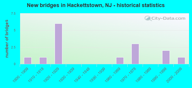
- New bridges - historical statistics
- 11900-1909
- 11910-1919
- 61920-1929
- 11960-1969
- 31970-1979
- 21990-1999
- 12000-2009

- Reconstructed bridges - Historical Statistics
- 11940-1949
- 11950-1959
- 01960-1969
- 01970-1979
- 31980-1989
- 21990-1999
- 22000-2009


- Bridge Condition - Deck
- 23.1%Good
- 46.2%Satisfactory
- 30.8%Fair

- Bridge Condition - Superstructure
- 7.7%Very good
- 15.4%Good
- 30.8%Satisfactory
- 46.2%Fair

- Bridge Condition - Substructure
- 23.1%Good
- 53.8%Satisfactory
- 23.1%Fair

- Bridge Condition - Channel
- 7.7%Very good
- 23.1%Good
- 53.8%Satisfactory
- 15.4%Fair

- Bridge Condition - Culverts
- 50.0%Good
- 50.0%Satisfactory
Find on map >> Show street view
Structure Number: 1401048, Location: JUNCT.AT RT.WARREN CO.604 (Lat: 40.880711, Lng: -74.807489), Route carried "on" structure: Other road , Year Built: 1900, Year Reconstructed: 1961, Status: Open, Structure Length: 2.44m (8.01ft), Average Daily Traffic: 111 (year 2021), Truck Traffic: 3%, Average Future Daily Traffic: 136 (year 2041), Features Intersected: MUSCONETCONG RIVER, Facility Carried by Structure: WATERLOO VALLEY RD
Minimum Vertical Clearance: 30+ m (98+ ft), Kilometerpoint: 0.032, Lanes on structure: 1, Owner: County Highway Agency, Approaching Roadway Width: 4.9m (16.1ft), Material/Design: Prestressed concrete, Design/Construction: Box Beam or Girders - Multiple, Number Of Spans In Main Unit: 3, Length of Maximum Span: 8.2m (26.9ft), Curb-To-Curb Width: 5.0m (16.4ft), Out-to-Out Width: 5.6m (18.4ft)
Condition: Deck: Fair, Superstructure: Fair, Substructure: Fair, Channel: Satisfactory, Operating Rating: 51.7 metric tons, Method Used To Determine Operating Rating: Field evaluation and documented engineering judgment, Inventory Rating: 30.8 metric tons, Method Used To Determine Inventory Rating: Field evaluation and documented engineering judgment, Structural Evaluation: Somewhat better than minimum adequacy, Deck Geometry: High priority of replacement, Waterway Adequacy: Equal to present desirable criteria, Approach Roadway Alignment: Meets minimum limits, Length Of Structure Improvement: 2.44m (8.01ft), Designated Inspection Frequency: Every 24 months, Inspection Date: July 2021, Bridge Improvement Cost: $771,000, Roadway Improvement Cost: $78,000, Total Project Cost: $1,193,000 ( Estimate for 2021), Deck Structure Type: Concrete Precast Panels, Wearing Surface/Protective System: Wearing Surface: Bituminous
Find on map >> Show street view
Structure Number: 140109, Location: .2 miles south of US 46 (Lat: 40.841561, Lng: -74.801639), Route carried "on" structure: City street , Year Built: 1970, Status: Open, Structure Length: 0.70m (2.30ft), Average Daily Traffic: 1,106 (year 2021), Truck Traffic: 1%, Average Future Daily Traffic: 1,350 (year 2041), Design Load: HS 20, Features Intersected: TRIBUTARY OF MINE BROOK, Facility Carried by Structure: RESERVOIR ROAD
Minimum Vertical Clearance: 30+ m (98+ ft), Kilometerpoint: 0.000, Lanes on structure: 2, Owner: County Highway Agency, Approaching Roadway Width: 7.7m (25.3ft), Skew: 2 degrees, Material/Design: Steel, Design/Construction: Culvert, Number Of Spans In Main Unit: 2, Length of Maximum Span: 3.4m (11.2ft)
Condition: Channel: Satisfactory, Culverts: Satisfactory, Operating Rating: 47.2 metric tons, Method Used To Determine Operating Rating: Load Factor (LF), Inventory Rating: 39.9 metric tons, Method Used To Determine Inventory Rating: Load Factor (LF), Structural Evaluation: Equal to present minimum criteria, Waterway Adequacy: Better than present minimum criteria, Approach Roadway Alignment: Equal to present minimum criteria, Designated Inspection Frequency: Every 24 months, Inspection Date: August 2021
Find on map >> Show street view
Structure Number: 1401195, Location: 0.1 MILE EAST OF NJ RT182 (Lat: 40.841961, Lng: -74.821531), Route carried "on" structure: City street , Year Built: 1967, Status: Open, Structure Length: 1.77m (5.81ft), Average Daily Traffic: 14,375 (year 2021), Truck Traffic: 3%, Average Future Daily Traffic: 17,541 (year 2041), Features Intersected: MUSCONETCONG RIVER, Facility Carried by Structure: EAST AVE
Minimum Vertical Clearance: 30+ m (98+ ft), Kilometerpoint: 0.982, Lanes on structure: 2, Owner: County Highway Agency, Approaching Roadway Width: 8.2m (26.9ft), Material/Design: Prestressed concrete, Design/Construction: Box Beam or Girders - Multiple, Number Of Spans In Main Unit: 1, Length of Maximum Span: 16.2m (53.1ft), Curb or Sidewalk Widths: Left: 1.2m (3.9ft), Right: 1.2m (3.9ft), Curb-To-Curb Width: 8.7m (28.5ft), Out-to-Out Width: 11.1m (36.4ft)
Condition: Deck: Fair, Superstructure: Fair, Substructure: Satisfactory, Channel: Satisfactory, Operating Rating: 46.3 metric tons, Method Used To Determine Operating Rating: Load Factor (LF), Inventory Rating: 27.2 metric tons, Method Used To Determine Inventory Rating: Load Factor (LF), Structural Evaluation: Somewhat better than minimum adequacy, Deck Geometry: High priority of replacement, Waterway Adequacy: Equal to present desirable criteria, Approach Roadway Alignment: Equal to present minimum criteria, Length Of Structure Improvement: 1.77m (5.81ft), Designated Inspection Frequency: Every 24 months, Underwater Inspection Frequency: Every 48 months, Inspection Date: July 2021, Underwater Inspection Date: August 2021, Bridge Improvement Cost: $80,000, Roadway Improvement Cost: $8,000, Total Project Cost: $121,000 ( Estimate for 2021), Deck Structure Type: Concrete Precast Panels, Wearing Surface/Protective System: Wearing Surface: Bituminous
Find on map >> Show street view
Structure Number: 1401236, Location: 0.2 mile south of US 46 (Lat: 40.841569, Lng: -74.811650), Route carried "on" structure: Other road , Year Built: 2002, Status: Open, Structure Length: 1.92m (6.30ft), Average Daily Traffic: 1,205 (year 2021), Truck Traffic: 1%, Average Future Daily Traffic: 1,470 (year 2041), Features Intersected: MINE BROOK, Facility Carried by Structure: HERON DRIVE
Minimum Vertical Clearance: 30+ m (98+ ft), Kilometerpoint: 0.000, Lanes on structure: 2, Owner: County Highway Agency, Approaching Roadway Width: 7.9m (25.9ft), Skew: 2 degrees, Material/Design: Concrete, Design/Construction: Culvert, Number Of Spans In Main Unit: 3, Length of Maximum Span: 4.6m (15.1ft), Curb or Sidewalk Widths: Left: 1.2m (3.9ft), Right: 0.0m
Condition: Channel: Very good, Culverts: Good, Operating Rating: 59.9 metric tons, Method Used To Determine Operating Rating: Field evaluation and documented engineering judgment, Inventory Rating: 36.3 metric tons, Method Used To Determine Inventory Rating: Field evaluation and documented engineering judgment, Structural Evaluation: Better than present minimum criteria, Waterway Adequacy: Equal to present desirable criteria, Approach Roadway Alignment: Equal to present desirable criteria, Designated Inspection Frequency: Every 24 months, Inspection Date: July 2021
Find on map >> Show street view
Structure Number: 140715, Location: 0.21 MI E OF CR 604 (Lat: 40.848369, Lng: -74.820669), Route carried "on" structure: US 46, Year Built: 1921, Year Reconstructed: 1952, Status: Open, Structure Length: 0.79m (2.59ft), Average Daily Traffic: 12,865 (year 2021), Truck Traffic: 4%, Average Future Daily Traffic: 15,438 (year 2041), Features Intersected: MILL RACE
Minimum Vertical Clearance: 30+ m (98+ ft), Kilometerpoint: 35.212, Lanes on structure: 2, Base Highway Network: Yes, Owner: State Highway Agency, Approaching Roadway Width: 9.1m (29.9ft), Material/Design: Steel, Design/Construction: Stringer/Multi-beam, Number Of Spans In Main Unit: 1, Length of Maximum Span: 6.7m (22.0ft), Curb or Sidewalk Widths: Left: 0.0m, Right: 2.4m (7.9ft), Curb-To-Curb Width: 9.0m (29.5ft), Out-to-Out Width: 12.2m (40.0ft)
Condition: Deck: Fair, Superstructure: Fair, Substructure: Fair, Channel: Satisfactory, Operating Rating: 59.0 metric tons, Method Used To Determine Operating Rating: Load Factor (LF), Inventory Rating: 35.4 metric tons, Method Used To Determine Inventory Rating: Load Factor (LF), Structural Evaluation: Somewhat better than minimum adequacy, Deck Geometry: High priority of replacement, Waterway Adequacy: Equal to present desirable criteria, Approach Roadway Alignment: Equal to present desirable criteria, Length Of Structure Improvement: 0.79m (2.59ft), Designated Inspection Frequency: Every 24 months, Inspection Date: May 2021, Bridge Improvement Cost: $32,000, Roadway Improvement Cost: $126,000, Total Project Cost: $208,000 ( Estimate for 2021), Deck Structure Type: Concrete Cast-file-Place, Wearing Surface/Protective System: Wearing Surface: Bituminous
Find on map >> Show street view
Structure Number: 1407152, Location: 0.79 MI E OF CR 604 (Lat: 40.844475, Lng: -74.810931), Route carried "on" structure: US 46, Year Built: 1921, Year Reconstructed: 1986, Status: Open, Structure Length: 1.10m (3.61ft), Average Daily Traffic: 13,920 (year 2021), Truck Traffic: 4%, Average Future Daily Traffic: 16,985 (year 2041), Design Load: HS 20, Features Intersected: MINE BROOK
Minimum Vertical Clearance: 30+ m (98+ ft), Kilometerpoint: 36.065, Lanes on structure: 6, Base Highway Network: Yes, Owner: State Highway Agency, Approaching Roadway Width: 24.7m (81.0ft), Material/Design: Steel, Design/Construction: Stringer/Multi-beam, Number Of Spans In Main Unit: 1, Length of Maximum Span: 9.8m (32.2ft), Curb or Sidewalk Widths: Left: 1.4m (4.6ft), Right: 1.8m (5.9ft), Curb-To-Curb Width: 24.5m (80.4ft), Out-to-Out Width: 28.8m (94.5ft)
Condition: Deck: Satisfactory, Superstructure: Fair, Substructure: Satisfactory, Channel: Satisfactory, Operating Rating: 59.9 metric tons, Method Used To Determine Operating Rating: Load Factor (LF), Inventory Rating: 35.4 metric tons, Method Used To Determine Inventory Rating: Load Factor (LF), Structural Evaluation: Somewhat better than minimum adequacy, Deck Geometry: Somewhat better than minimum adequacy, Waterway Adequacy: Equal to present minimum criteria, Approach Roadway Alignment: Equal to present desirable criteria, Length Of Structure Improvement: 1.10m (3.61ft), Designated Inspection Frequency: Every 24 months, Inspection Date: March 2021, Bridge Improvement Cost: $452,000, Total Project Cost: $452,000 ( Estimate for 2021), Deck Structure Type: Concrete Cast-file-Place, Wearing Surface/Protective System: Wearing Surface: Bituminous
Find on map >> Show street view
Structure Number: 1407153, Location: 0.93 MI E OF CR 604 (Lat: 40.843339, Lng: -74.808539), Route carried "on" structure: US 46, Year Built: 1921, Year Reconstructed: 1986, Status: Open, Structure Length: 1.16m (3.81ft), Average Daily Traffic: 8,053 (year 2021), Truck Traffic: 4%, Average Future Daily Traffic: 8,493 (year 2041), Features Intersected: BRANCH MINE BROOK
Minimum Vertical Clearance: 30+ m (98+ ft), Kilometerpoint: 36.355, Lanes on structure: 2, Base Highway Network: Yes, Owner: State Highway Agency, Approaching Roadway Width: 9.1m (29.9ft), Skew: 4 degrees, Material/Design: Steel, Design/Construction: Stringer/Multi-beam, Number Of Spans In Main Unit: 1, Length of Maximum Span: 9.8m (32.2ft), Curb-To-Curb Width: 9.1m (29.9ft), Out-to-Out Width: 10.2m (33.5ft)
Condition: Deck: Satisfactory, Superstructure: Fair, Substructure: Satisfactory, Channel: Satisfactory, Operating Rating: 75.3 metric tons, Method Used To Determine Operating Rating: Load Factor (LF), Inventory Rating: 45.4 metric tons, Method Used To Determine Inventory Rating: Load Factor (LF), Structural Evaluation: Somewhat better than minimum adequacy, Deck Geometry: Meets minimum limits, Waterway Adequacy: Equal to present minimum criteria, Approach Roadway Alignment: Better than present minimum criteria, Length Of Structure Improvement: 1.16m (3.81ft), Designated Inspection Frequency: Every 24 months, Inspection Date: March 2021, Bridge Improvement Cost: $347,000, Total Project Cost: $347,000 ( Estimate for 2021), Deck Structure Type: Concrete Cast-file-Place, Wearing Surface/Protective System: Wearing Surface: Monolithic Concrete, Deck Protection: Epoxy Coated Reinforcing
Find on map >> Show street view
Structure Number: 1407154, Location: 1.1 MI E OF CR 604 (Lat: 40.842589, Lng: -74.805600), Route carried "on" structure: US 46, Year Built: 1921, Year Reconstructed: 1986, Status: Open, Structure Length: 1.13m (3.71ft), Average Daily Traffic: 21,975 (year 2021), Truck Traffic: 4%, Average Future Daily Traffic: 26,812 (year 2041), Design Load: HS 20+Mod, Features Intersected: BRANCH OF MINE BROOK
Minimum Vertical Clearance: 30+ m (98+ ft), Kilometerpoint: 36.661, Lanes on structure: 2, Base Highway Network: Yes, Owner: State Highway Agency, Approaching Roadway Width: 9.4m (30.8ft), Skew: 4 degrees, Material/Design: Steel, Design/Construction: Stringer/Multi-beam, Number Of Spans In Main Unit: 1, Length of Maximum Span: 9.8m (32.2ft), Curb-To-Curb Width: 9.3m (30.5ft), Out-to-Out Width: 10.2m (33.5ft)
Condition: Deck: Satisfactory, Superstructure: Satisfactory, Substructure: Satisfactory, Channel: Fair, Operating Rating: 56.2 metric tons, Method Used To Determine Operating Rating: Load Factor (LF), Inventory Rating: 33.6 metric tons, Method Used To Determine Inventory Rating: Load Factor (LF), Structural Evaluation: Equal to present minimum criteria, Deck Geometry: Meets minimum limits, Waterway Adequacy: Equal to present minimum criteria, Approach Roadway Alignment: Equal to present minimum criteria, Designated Inspection Frequency: Every 24 months, Inspection Date: March 2021, Deck Structure Type: Concrete Cast-file-Place, Wearing Surface/Protective System: Wearing Surface: Monolithic Concrete, Deck Protection: Epoxy Coated Reinforcing
Find on map >> Show street view
Structure Number: 2100806, Location: 50 FT.SOUTH OF NJ RT 57 (Lat: 40.834511, Lng: -74.822839), Route carried "on" structure: County highway 517, Year Built: 1996, Status: Open, Structure Length: 3.29m (10.79ft), Average Daily Traffic: 10,107 (year 2021), Truck Traffic: 3%, Average Future Daily Traffic: 12,332 (year 2041), Design Load: HS 20+Mod, Features Intersected: MUSCONETCONG RIVER
Minimum Vertical Clearance: 30+ m (98+ ft), Kilometerpoint: 23.255, Lanes on structure: 4, Owner: County Highway Agency, Approaching Roadway Width: 15.2m (49.9ft), Skew: 1 degrees, Material/Design: Prestressed concrete, Design/Construction: Slab, Number Of Spans In Main Unit: 2, Length of Maximum Span: 15.8m (51.8ft), Curb or Sidewalk Widths: Left: 1.9m (6.2ft), Right: 1.9m (6.2ft), Curb-To-Curb Width: 15.2m (49.9ft), Out-to-Out Width: 19.7m (64.6ft)
Condition: Deck: Satisfactory, Superstructure: Satisfactory, Substructure: Good, Channel: Good, Operating Rating: 65.3 metric tons, Method Used To Determine Operating Rating: Load Factor (LF), Inventory Rating: 39.0 metric tons, Method Used To Determine Inventory Rating: Load Factor (LF), Structural Evaluation: Equal to present minimum criteria, Deck Geometry: High priority of corrective action, Waterway Adequacy: Superior to present desirable criteria, Approach Roadway Alignment: Equal to present desirable criteria, Designated Inspection Frequency: Every 24 months, Inspection Date: March 2021, Deck Structure Type: Concrete Cast-file-Place, Wearing Surface/Protective System: Wearing Surface: Monolithic Concrete, Deck Protection: Epoxy Coated Reinforcing
Find on map >> Show street view
Structure Number: 210081A, Location: 0.2 MI SW OF US 46 JCT (Lat: 40.853261, Lng: -74.835931), Route carried "on" structure: City street , Year Built: 1973, Year Reconstructed: 2014, Status: Open, Structure Length: 1.01m (3.31ft), Average Daily Traffic: 2,230 (year 2021), Truck Traffic: 1%, Average Future Daily Traffic: 2,680 (year 2041), Design Load: HL 93, Features Intersected: TROUT BROOK, Facility Carried by Structure: CHARLES STREET
Minimum Vertical Clearance: 30+ m (98+ ft), Kilometerpoint: 0.000, Lanes on structure: 2, Owner: County Highway Agency, Approaching Roadway Width: 9.4m (30.8ft), Skew: 1 degrees, Material/Design: Prestressed concrete, Design/Construction: Slab, Number Of Spans In Main Unit: 1, Length of Maximum Span: 9.4m (30.8ft), Curb or Sidewalk Widths: Left: 1.9m (6.2ft), Right: 0.2m (0.7ft), Curb-To-Curb Width: 8.8m (28.9ft), Out-to-Out Width: 11.9m (39.0ft)
Condition: Deck: Good, Superstructure: Very good, Substructure: Good, Channel: Fair, Operating Rating: 62.9 metric tons, Method Used To Determine Operating Rating: Load and Resistance Factor Rating (LRFR) rating reported by rating factor(RF) method using HL-93 loadings, Inventory Rating: 48.6 metric tons, Method Used To Determine Inventory Rating: Load and Resistance Factor Rating (LRFR) rating reported by rating factor(RF) method using HL-93 loadings, Structural Evaluation: Better than present minimum criteria, Deck Geometry: Meets minimum limits, Waterway Adequacy: Better than present minimum criteria, Approach Roadway Alignment: Equal to present desirable criteria, Designated Inspection Frequency: Every 24 months, Inspection Date: March 2021, Deck Structure Type: Concrete Cast-file-Place, Wearing Surface/Protective System: Deck Protection: Galvanized Reinforcing
Find on map >> Show street view
Structure Number: 2106165, Location: 0.5 MI SW OF RT24&182 JCT (Lat: 40.829531, Lng: -74.831189), Route carried "on" structure: State highway 57, Year Built: 1924, Year Reconstructed: 2002, Status: Open, Structure Length: 0.73m (2.40ft), Average Daily Traffic: 25,006 (year 2020), Truck Traffic: 4%, Average Future Daily Traffic: 30,513 (year 2040), Design Load: H 20, Features Intersected: TROUT BROOK
Minimum Vertical Clearance: 30.45m (99.90ft), Kilometerpoint: 33.056, Lanes on structure: 3, Base Highway Network: Yes, Owner: State Highway Agency, Approaching Roadway Width: 16.5m (54.1ft), Skew: 2 degrees, Material/Design: Steel, Design/Construction: Stringer/Multi-beam, Number Of Spans In Main Unit: 1, Length of Maximum Span: 6.7m (22.0ft), Curb-To-Curb Width: 16.6m (54.5ft), Out-to-Out Width: 17.8m (58.4ft)
Condition: Deck: Satisfactory, Superstructure: Good, Substructure: Satisfactory, Channel: Good, Operating Rating: 86.2 metric tons, Method Used To Determine Operating Rating: Load Factor (LF), Inventory Rating: 51.7 metric tons, Method Used To Determine Inventory Rating: Load Factor (LF), Structural Evaluation: Equal to present minimum criteria, Deck Geometry: Equal to present desirable criteria, Waterway Adequacy: Equal to present desirable criteria, Approach Roadway Alignment: Equal to present desirable criteria, Designated Inspection Frequency: Every 24 months, Inspection Date: June 2020, Deck Structure Type: Concrete Cast-file-Place, Wearing Surface/Protective System: Wearing Surface: Bituminous
Find on map >> Show street view
Structure Number: 2108162, Location: 0.15 MI EAST OF CR 604 (Lat: 40.848481, Lng: -74.821919), Route carried "on" structure: US 46, Year Built: 1924, Year Reconstructed: 2014, Status: Open, Structure Length: 3.93m (12.89ft), Average Daily Traffic: 13,920 (year 2021), Truck Traffic: 4%, Average Future Daily Traffic: 16,985 (year 2041), Design Load: HL 93, Features Intersected: MUSCONETCONG RIVER
Minimum Vertical Clearance: 30+ m (98+ ft), Kilometerpoint: 35.132, Lanes on structure: 2, Base Highway Network: Yes, Owner: State Highway Agency, Approaching Roadway Width: 9.1m (29.9ft), Material/Design: Prestressed concrete, Design/Construction: Tee Beam, Number Of Spans In Main Unit: 2, Length of Maximum Span: 18.6m (61.0ft), Curb or Sidewalk Widths: Left: 0.0m, Right: 1.8m (5.9ft), Curb-To-Curb Width: 9.1m (29.9ft), Out-to-Out Width: 12.1m (39.7ft)
Condition: Deck: Good, Superstructure: Good, Substructure: Good, Channel: Good, Operating Rating: 65.8 metric tons, Method Used To Determine Operating Rating: Load and Resistance Factor Rating (LRFR) rating reported by rating factor(RF) method using HL-93 loadings, Inventory Rating: 50.5 metric tons, Method Used To Determine Inventory Rating: Load and Resistance Factor Rating (LRFR) rating reported by rating factor(RF) method using HL-93 loadings, Structural Evaluation: Better than present minimum criteria, Deck Geometry: High priority of corrective action, Waterway Adequacy: Superior to present desirable criteria, Approach Roadway Alignment: Equal to present desirable criteria, Length Of Structure Improvement: 3.93m (12.89ft), Designated Inspection Frequency: Every 24 months, Inspection Date: April 2021, Bridge Improvement Cost: $175,000, Roadway Improvement Cost: $35,000, Total Project Cost: $1,052,000 ( Estimate for 2021), Deck Structure Type: Concrete Precast Panels, Wearing Surface/Protective System: Wearing Surface: Bituminous, Membrane: Other, Deck Protection: Epoxy Coated Reinforcing
Find on map >> Show street view
Structure Number: 215417, Location: 1.25 MI North RT 57 (Lat: 40.837111, Lng: -74.849811), Route carried "on" structure: City street , Year Built: 1913, Year Reconstructed: 1990, Status: Open, Structure Length: 1.10m (3.61ft), Average Daily Traffic: 1,580 (year 2020), Truck Traffic: 4%, Average Future Daily Traffic: 1,930 (year 2040), Design Load: HS 20+Mod, Features Intersected: WASHINGTON SEC (NS), Facility Carried by Structure: ALLEN ROAD
Minimum Vertical Clearance: 30+ m (98+ ft), Kilometerpoint: 2.012, Lanes on structure: 2, Maintenance Responsibility: State Highway Agency, Approaching Roadway Width: 6.1m (20.0ft), Material/Design: Wood or Timber, Design/Construction: Slab, Number Of Spans In Main Unit: 1, Length of Maximum Span: 10.1m (33.1ft), Curb-To-Curb Width: 6.2m (20.3ft), Out-to-Out Width: 6.7m (22.0ft)
Condition: Deck: Satisfactory, Superstructure: Satisfactory, Substructure: Satisfactory, Operating Rating: 50.8 metric tons, Method Used To Determine Operating Rating: Allowable Stress (AS), Inventory Rating: 33.6 metric tons, Method Used To Determine Inventory Rating: Allowable Stress (AS), Structural Evaluation: Equal to present minimum criteria, Deck Geometry: High priority of replacement, Underclear: High priority of corrective action, Approach Roadway Alignment: Somewhat better than minimum adequacy, Length Of Structure Improvement: 1.10m (3.61ft), Designated Inspection Frequency: Every 24 months, Inspection Date: October 2020, Bridge Improvement Cost: $49,000, Roadway Improvement Cost: $113,000, Total Project Cost: $417,000 ( Estimate for 2020), Deck Structure Type: Wood or Timber, Wearing Surface/Protective System: Wearing Surface: Bituminous
Find on map >> Show street view
Structure Number: 2154171, Location: 1.3MI NE US46&CR517 JCT (Lat: 40.869119, Lng: -74.815300), Route carried "on" structure: County highway 665, Year Built: 1973, Status: Open, Structure Length: 4.05m (13.29ft), Average Daily Traffic: 6,573 (year 2021), Truck Traffic: 4%, Average Future Daily Traffic: 8,020 (year 2041), Design Load: HS 20, Features Intersected: WASHINGTON SECONDARY
Minimum Vertical Clearance: 30+ m (98+ ft), Kilometerpoint: 0.515, Lanes on structure: 2, Maintenance Responsibility: State Highway Agency, Approaching Roadway Width: 10.7m (35.1ft), Skew: 3 degrees, Material/Design: Prestressed concrete, Design/Construction: Box Beam or Girders - Multiple, Number Of Spans In Main Unit: 3, Length of Maximum Span: 13.1m (43.0ft), Curb or Sidewalk Widths: Left: 0.4m (1.3ft), Right: 1.2m (3.9ft), Curb-To-Curb Width: 8.6m (28.2ft), Out-to-Out Width: 11.1m (36.4ft)
Condition: Deck: Fair, Superstructure: Fair, Substructure: Fair, Operating Rating: 49.0 metric tons, Method Used To Determine Operating Rating: Load Factor (LF), Inventory Rating: 29.0 metric tons, Method Used To Determine Inventory Rating: Load Factor (LF), Structural Evaluation: Somewhat better than minimum adequacy, Deck Geometry: High priority of replacement, Underclear: Equal to present minimum criteria, Approach Roadway Alignment: Equal to present minimum criteria, Length Of Structure Improvement: 4.05m (13.29ft), Designated Inspection Frequency: Every 24 months, Inspection Date: September 2021, Bridge Improvement Cost: $175,000, Roadway Improvement Cost: $53,000, Total Project Cost: $190,000 ( Estimate for 2021), Deck Structure Type: Concrete Precast Panels, Wearing Surface/Protective System: Wearing Surface: Bituminous
Find on map >> Show street view
Structure Number: 330515, Location: 3.6 MI SW OF RT80&206 JCT (Lat: 40.873269, Lng: -74.806331), Route carried "on" structure: State lands road , Year Built: 1998, Status: Open, Structure Length: 2.01m (6.59ft), Average Daily Traffic: 106 (year 2021), Truck Traffic: 3%, Average Future Daily Traffic: 129 (year 2041), Design Load: HS 20, Features Intersected: MUSCONETCONG RIVER, Facility Carried by Structure: PARK ROAD
Minimum Vertical Clearance: 30+ m (98+ ft), Kilometerpoint: 0.000, Lanes on structure: 1, Owner: State Agenciy, Approaching Roadway Width: 4.0m (13.1ft), Material/Design: Steel, Design/Construction: Stringer/Multi-beam, Number Of Spans In Main Unit: 2, Length of Maximum Span: 8.8m (28.9ft), Curb-To-Curb Width: 4.8m (15.7ft), Out-to-Out Width: 5.1m (16.7ft)
Condition: Deck: Good, Superstructure: Satisfactory, Substructure: Satisfactory, Channel: Satisfactory, Operating Rating: 58.1 metric tons, Method Used To Determine Operating Rating: Load Factor (LF), Inventory Rating: 34.5 metric tons, Method Used To Determine Inventory Rating: Load Factor (LF), Structural Evaluation: Equal to present minimum criteria, Deck Geometry: High priority of corrective action, Waterway Adequacy: Better than present minimum criteria, Approach Roadway Alignment: Meets minimum limits, Length Of Structure Improvement: 2.01m (6.59ft), Designated Inspection Frequency: Every 24 months, Inspection Date: September 2021, Bridge Improvement Cost: $99,000, Roadway Improvement Cost: $20,000, Total Project Cost: $155,000 ( Estimate for 2021), Deck Structure Type: Wood or Timber