Bridge Statistics for Hackensack, New Jersey (NJ)
Condition, Traffic, Stress, Structural Evaluation, Project Costs
- National Bridge Inventory (NBI) Statistics
- 47Number of bridges
- 646ft / 197mTotal length
- $64,842,000Total costs
- 2,146,855Total average daily traffic
- 138,001Total average daily truck traffic
- National Bridge Inventory (NBI) Registered Bridges for Hackensack
- No street view available for this location
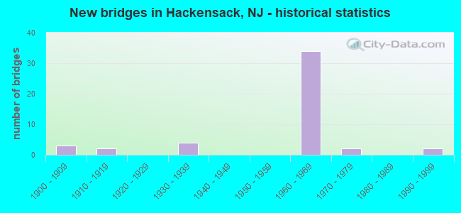
- New bridges - historical statistics
- 31900-1909
- 21910-1919
- 41930-1939
- 341960-1969
- 21970-1979
- 21990-1999

- Reconstructed bridges - Historical Statistics
- 11950-1959
- 01960-1969
- 01970-1979
- 21980-1989
- 81990-1999
- 42000-2009


- Bridge Condition - Deck
- 9.1%Very good
- 36.4%Good
- 36.4%Satisfactory
- 9.1%Fair
- 9.1%Poor

- Bridge Condition - Superstructure
- 12.0%Very good
- 32.0%Good
- 28.0%Satisfactory
- 24.0%Fair
- 4.0%Poor

- Bridge Condition - Substructure
- 24.0%Good
- 48.0%Satisfactory
- 28.0%Fair

- Bridge Condition - Channel
- 23.1%Very good
- 38.5%Good
- 23.1%Satisfactory
- 15.4%Fair
Find on map >> Show street view
Structure Number: 20004A, Location: HACKENSACK R 1MI N OF I80 (Lat: 40.879100, Lng: -74.040281), Route carried "on" structure: County highway 56, Year Built: 1908, Year Reconstructed: 2012, Status: Open, Structure Length: 9.60m (31.50ft), Average Daily Traffic: 18,936 (year 2020), Truck Traffic: 4%, Average Future Daily Traffic: 23,106 (year 2040), Design Load: HS 25 or greater, Features Intersected: HACKENSACK RIVER
Minimum Vertical Clearance: 4.80m (15.75ft), Kilometerpoint: 8.739, Lanes on structure: 2, Owner: County Highway Agency, Approaching Roadway Width: 9.1m (29.9ft), Navigation Control: Yes ( Vertical Clearance: 1.2m (3.9ft), Horizontal Clearance: 17.4m (57.1ft)), Material/Design: Steel, Design/Construction: Movable - Swing, Number Of Spans In Main Unit: 2, Number Of Approach Spans: 2, Length of Maximum Span: 26.5m (86.9ft), Curb or Sidewalk Widths: Left: 1.5m (4.9ft), Right: 1.5m (4.9ft), Curb-To-Curb Width: 9.1m (29.9ft), Out-to-Out Width: 10.4m (34.1ft)
Condition: Deck: Good, Superstructure: Good, Substructure: Good, Channel: Good, Operating Rating: 72.6 metric tons, Method Used To Determine Operating Rating: Load Factor (LF), Inventory Rating: 43.5 metric tons, Method Used To Determine Inventory Rating: Load Factor (LF), Structural Evaluation: Better than present minimum criteria, Deck Geometry: Meets minimum limits, Waterway Adequacy: Better than present minimum criteria, Approach Roadway Alignment: Equal to present desirable criteria, Designated Inspection Frequency: Every 24 months, Critical Feature Inspection Frequency: Every 24 months, Underwater Inspection Frequency: Every 48 months, Inspection Date: June 2020, Critical Feature Inspection Date: June 2020, Underwater Inspection Date: September 2020, Deck Structure Type: Concrete Cast-file-Place, Wearing Surface/Protective System: Wearing Surface: Monolithic Concrete, Deck Protection: Epoxy Coated Reinforcing
Find on map >> Show street view
Structure Number: 20023A, Location: 0.36 MI E OF CR 62 (Lat: 40.891919, Lng: -74.036781), Route carried "on" structure: County highway 60, Year Built: 1971, Status: Posted for load, Structure Length: 9.27m (30.41ft), Average Daily Traffic: 18,945 (year 2020), Truck Traffic: 4%, Average Future Daily Traffic: 23,116 (year 2040), Design Load: HS 20, Features Intersected: HACKENSACK RIVER
Minimum Vertical Clearance: 30+ m (98+ ft), Kilometerpoint: 0.579, Lanes on structure: 4, Owner: County Highway Agency, Approaching Roadway Width: 15.8m (51.8ft), Skew: 20 degrees, Navigation Control: Yes ( Vertical Clearance: 2.7m (8.9ft), Horizontal Clearance: 14.9m (48.9ft)), Material/Design: Prestressed concrete, Design/Construction: Box Beam or Girders - Multiple, Number Of Spans In Main Unit: 6, Length of Maximum Span: 14.9m (48.9ft), Curb or Sidewalk Widths: Left: 1.5m (4.9ft), Right: 1.5m (4.9ft), Curb-To-Curb Width: 15.8m (51.8ft), Out-to-Out Width: 22.6m (74.1ft)
Condition: Deck: Poor, Superstructure: Poor, Substructure: Fair, Channel: Good, Operating Rating: 7.3 metric tons, Method Used To Determine Operating Rating: Load Factor (LF), Inventory Rating: 4.5 metric tons, Method Used To Determine Inventory Rating: Load Factor (LF), Structural Evaluation: High priority of replacement, Deck Geometry: Meets minimum limits, Waterway Adequacy: Superior to present desirable criteria, Approach Roadway Alignment: Equal to present desirable criteria, Bridge Posting: Required (Relationship of Operating Rating to Maximum Legal Load: > 39.9% below), Length Of Structure Improvement: 9.27m (30.41ft), Designated Inspection Frequency: Every 24 months, Underwater Inspection Frequency: Every 48 months, Other Special Inspection Frequency: Every 12 months, Inspection Date: April 2020, Underwater Inspection Date: May 2018, Other Special Inspection Date: April 2021, Bridge Improvement Cost: $11,158,000, Roadway Improvement Cost: $175,000, Total Project Cost: $16,810,000 ( Estimate for 2020), Deck Structure Type: Concrete Precast Panels, Wearing Surface/Protective System: Wearing Surface: Bituminous
Find on map >> Show street view
Structure Number: 20023B, Location: 100 FT S OF NJ 4 (Lat: 40.910969, Lng: -74.039831), Route carried "on" structure: City street , Year Built: 1900, Year Reconstructed: 1994, Status: Open, Structure Length: 1.77m (5.81ft), Average Daily Traffic: 5,076 (year 2020), Truck Traffic: 3%, Average Future Daily Traffic: 6,193 (year 2040), Design Load: HS 25 or greater, Features Intersected: COLES BROOK, Facility Carried by Structure: MAIN STREET
Minimum Vertical Clearance: 30+ m (98+ ft), Kilometerpoint: 1.143, Lanes on structure: 1, Owner: County Highway Agency, Approaching Roadway Width: 6.7m (22.0ft), Skew: 9 degrees, Material/Design: Steel, Design/Construction: Stringer/Multi-beam, Number Of Spans In Main Unit: 2, Length of Maximum Span: 8.8m (28.9ft), Curb or Sidewalk Widths: Left: 3.9m (12.8ft), Right: 6.8m (22.3ft), Curb-To-Curb Width: 6.7m (22.0ft), Out-to-Out Width: 19.5m (64.0ft)
Condition: Deck: Satisfactory, Superstructure: Fair, Substructure: Fair, Channel: Good, Operating Rating: 81.6 metric tons, Method Used To Determine Operating Rating: Load Factor (LF), Inventory Rating: 49.0 metric tons, Method Used To Determine Inventory Rating: Load Factor (LF), Structural Evaluation: Somewhat better than minimum adequacy, Deck Geometry: High priority of replacement, Waterway Adequacy: Equal to present minimum criteria, Approach Roadway Alignment: Somewhat better than minimum adequacy, Length Of Structure Improvement: 1.77m (5.81ft), Designated Inspection Frequency: Every 24 months, Inspection Date: April 2020, Roadway Improvement Cost: $31,000, Total Project Cost: $408,000 ( Estimate for 2020), Deck Structure Type: Concrete Cast-file-Place, Wearing Surface/Protective System: Wearing Surface: Monolithic Concrete, Deck Protection: Epoxy Coated Reinforcing
Find on map >> Show street view
Structure Number: 20023C, Location: .06 MI. S OF CENTRAL AVE (Lat: 40.890731, Lng: -74.056281), Route carried "on" structure: County highway 57, Year Built: 1911, Status: Open, Structure Length: 1.83m (6.00ft), Average Daily Traffic: 24,376 (year 2020), Truck Traffic: 4%, Average Future Daily Traffic: 29,743 (year 2040), Features Intersected: NYS & W RAILROAD
Minimum Vertical Clearance: 30+ m (98+ ft), Kilometerpoint: 0.789, Lanes on structure: 2, Owner: County Highway Agency, Approaching Roadway Width: 12.2m (40.0ft), Skew: 2 degrees, Material/Design: Concrete, Design/Construction: Arch - Deck, Number Of Spans In Main Unit: 1, Length of Maximum Span: 18.3m (60.0ft), Curb or Sidewalk Widths: Left: 1.5m (4.9ft), Right: 1.5m (4.9ft), Curb-To-Curb Width: 12.2m (40.0ft), Out-to-Out Width: 17.0m (55.8ft)
Condition: Superstructure: Satisfactory, Substructure: Satisfactory, Operating Rating: 89.8 metric tons, Method Used To Determine Operating Rating: Field evaluation and documented engineering judgment, Inventory Rating: 89.8 metric tons, Method Used To Determine Inventory Rating: Field evaluation and documented engineering judgment, Structural Evaluation: Equal to present minimum criteria, Deck Geometry: Somewhat better than minimum adequacy, Underclear: Meets minimum limits, Approach Roadway Alignment: Equal to present desirable criteria, Designated Inspection Frequency: Every 24 months, Inspection Date: May 2020
Find on map >> Show street view
Structure Number: 20023E, Location: JUST SOUTH OF NJ 4 (Lat: 40.910539, Lng: -74.039639), Route carried "on" structure: City street , Year Built: 1916, Status: Open, Structure Length: 1.01m (3.31ft), Average Daily Traffic: 2,618 (year 2020), Truck Traffic: 1%, Average Future Daily Traffic: 3,195 (year 2040), Features Intersected: COLES BROOK, Facility Carried by Structure: GRAND AVE
Minimum Vertical Clearance: 30+ m (98+ ft), Kilometerpoint: 0.000, Lanes on structure: 2, Owner: County Highway Agency, Approaching Roadway Width: 13.7m (44.9ft), Skew: 3 degrees, Material/Design: Concrete continuous, Design/Construction: Slab, Number Of Spans In Main Unit: 2, Length of Maximum Span: 4.9m (16.1ft), Curb or Sidewalk Widths: Left: 1.5m (4.9ft), Right: 1.2m (3.9ft), Curb-To-Curb Width: 13.7m (44.9ft), Out-to-Out Width: 22.9m (75.1ft)
Condition: Superstructure: Satisfactory, Substructure: Fair, Channel: Fair, Operating Rating: 33.6 metric tons, Method Used To Determine Operating Rating: Load Factor (LF), Inventory Rating: 20.0 metric tons, Method Used To Determine Inventory Rating: Load Factor (LF), Structural Evaluation: Somewhat better than minimum adequacy, Deck Geometry: Superior to present desirable criteria, Waterway Adequacy: Meets minimum limits, Approach Roadway Alignment: Equal to present desirable criteria, Designated Inspection Frequency: Every 24 months, Inspection Date: June 2020, Deck Structure Type: Concrete Cast-file-Place, Wearing Surface/Protective System: Wearing Surface: Bituminous
Find on map >> Show street view
Structure Number: 20023F, Location: 0.3 MI N OF NJ 4 (Lat: 40.910969, Lng: -74.033169), Route carried "on" structure: County highway 503, Year Built: 1979, Status: Open, Structure Length: 1.34m (4.40ft), Average Daily Traffic: 17,084 (year 2020), Truck Traffic: 4%, Average Future Daily Traffic: 20,846 (year 2040), Design Load: HS 20+Mod, Features Intersected: COLES BROOK
Minimum Vertical Clearance: 30+ m (98+ ft), Kilometerpoint: 11.941, Lanes on structure: 6, Base Highway Network: Yes, Owner: County Highway Agency, Approaching Roadway Width: 22.6m (74.1ft), Skew: 30 degrees, Material/Design: Prestressed concrete, Design/Construction: Box Beam or Girders - Multiple, Number Of Spans In Main Unit: 1, Length of Maximum Span: 12.5m (41.0ft), Curb or Sidewalk Widths: Left: 1.2m (3.9ft), Right: 1.2m (3.9ft), Curb-To-Curb Width: 22.6m (74.1ft), Out-to-Out Width: 28.3m (92.8ft)
Condition: Deck: Satisfactory, Superstructure: Satisfactory, Substructure: Satisfactory, Channel: Satisfactory, Operating Rating: 26.3 metric tons, Method Used To Determine Operating Rating: Load Factor (LF), Inventory Rating: 15.4 metric tons, Method Used To Determine Inventory Rating: Load Factor (LF), Structural Evaluation: High priority of corrective action, Deck Geometry: Meets minimum limits, Waterway Adequacy: Equal to present desirable criteria, Approach Roadway Alignment: Somewhat better than minimum adequacy, Length Of Structure Improvement: 1.34m (4.40ft), Designated Inspection Frequency: Every 24 months, Inspection Date: April 2020, Bridge Improvement Cost: $1,475,000, Roadway Improvement Cost: $70,000, Total Project Cost: $2,100,000 ( Estimate for 2020), Deck Structure Type: Other, Wearing Surface/Protective System: Wearing Surface: Bituminous
Find on map >> Show street view
Structure Number: 20023G, Location: 0.36 MI E OF CR 59 (Lat: 40.909050, Lng: -74.052119), Route carried "on" structure: City street , Year Built: 1962, Status: Open, Structure Length: 0.70m (2.30ft), Average Daily Traffic: 23,383 (year 2020), Truck Traffic: 4%, Average Future Daily Traffic: 28,532 (year 2040), Features Intersected: COLES BROOK, Facility Carried by Structure: SPRING VALLEY AVE
Minimum Vertical Clearance: 30+ m (98+ ft), Kilometerpoint: 1.802, Lanes on structure: 2, Owner: County Highway Agency, Approaching Roadway Width: 11.3m (37.1ft), Material/Design: Concrete, Design/Construction: Slab, Number Of Spans In Main Unit: 1, Length of Maximum Span: 6.4m (21.0ft), Curb or Sidewalk Widths: Left: 2.6m (8.5ft), Right: 2.6m (8.5ft), Curb-To-Curb Width: 12.2m (40.0ft), Out-to-Out Width: 18.0m (59.1ft)
Condition: Deck: Satisfactory, Superstructure: Satisfactory, Substructure: Good, Channel: Satisfactory, Operating Rating: 51.7 metric tons, Method Used To Determine Operating Rating: Load Factor (LF), Inventory Rating: 30.8 metric tons, Method Used To Determine Inventory Rating: Load Factor (LF), Structural Evaluation: Equal to present minimum criteria, Deck Geometry: Somewhat better than minimum adequacy, Waterway Adequacy: Equal to present minimum criteria, Approach Roadway Alignment: Equal to present desirable criteria, Designated Inspection Frequency: Every 24 months, Inspection Date: May 2020, Deck Structure Type: Concrete Cast-file-Place, Wearing Surface/Protective System: Wearing Surface: Monolithic Concrete
Find on map >> Show street view
Structure Number: 206163, Location: 2.1 MI E OF 4-17 JCT (Lat: 40.909039, Lng: -74.036569), Route carried "on" structure: State highway 4, Year Built: 1931, Year Reconstructed: 1998, Status: Open, Structure Length: 7.56m (24.80ft), Average Daily Traffic: 121,410 (year 2020), Truck Traffic: 5%, Average Future Daily Traffic: 145,692 (year 2040), Design Load: HS 25 or greater, Features Intersected: KNDRKMCK RD,RR&COLES BRK
Minimum Vertical Clearance: 30+ m (98+ ft), Kilometerpoint: 8.674, Lanes on structure: 8, Lanes under structure: 2, Base Highway Network: Yes, Owner: State Highway Agency, Approaching Roadway Width: 29.0m (95.1ft), Skew: 32 degrees, Material/Design: Prestressed concrete, Design/Construction: Stringer/Multi-beam, Number Of Spans In Main Unit: 3, Length of Maximum Span: 32.6m (107.0ft), Curb or Sidewalk Widths: Left: 1.8m (5.9ft), Right: 1.8m (5.9ft), Curb-To-Curb Width: 29.0m (95.1ft), Out-to-Out Width: 34.1m (111.9ft)
Condition: Deck: Good, Superstructure: Very good, Substructure: Satisfactory, Channel: Satisfactory, Operating Rating: 74.4 metric tons, Method Used To Determine Operating Rating: Load Factor (LF), Inventory Rating: 44.5 metric tons, Method Used To Determine Inventory Rating: Load Factor (LF), Structural Evaluation: Equal to present minimum criteria, Deck Geometry: High priority of corrective action, Underclear: Somewhat better than minimum adequacy, Waterway Adequacy: Superior to present desirable criteria, Approach Roadway Alignment: Better than present minimum criteria, Designated Inspection Frequency: Every 24 months, Inspection Date: May 2020, Deck Structure Type: Concrete Cast-file-Place, Wearing Surface/Protective System: Wearing Surface: Monolithic Concrete, Deck Protection: Epoxy Coated Reinforcing
Find on map >> Show street view
Structure Number: 206165, Location: 3.06 MI SOUTH OF NJ 17 (Lat: 40.905600, Lng: -74.033181), Route carried "on" structure: County highway 503, Year Built: 1998, Status: Open, Structure Length: 5.82m (19.09ft), Average Daily Traffic: 36,380 (year 2020), Truck Traffic: 4%, Average Future Daily Traffic: 43,656 (year 2040), Design Load: HS 25 or greater, Features Intersected: NJ 4
Minimum Vertical Clearance: 30+ m (98+ ft), Kilometerpoint: 11.346, Lanes on structure: 6, Lanes under structure: 8, Base Highway Network: Yes, Owner: State Highway Agency, Approaching Roadway Width: 23.2m (76.1ft), Skew: 24 degrees, Material/Design: Steel, Design/Construction: Stringer/Multi-beam, Number Of Spans In Main Unit: 2, Length of Maximum Span: 27.7m (90.9ft), Curb or Sidewalk Widths: Left: 1.8m (5.9ft), Right: 1.8m (5.9ft), Curb-To-Curb Width: 23.2m (76.1ft), Out-to-Out Width: 28.7m (94.2ft)
Condition: Deck: Good, Superstructure: Good, Substructure: Satisfactory, Inventory Rating: 74.4 metric tons, Method Used To Determine Inventory Rating: Load Factor (LF), Structural Evaluation: Equal to present minimum criteria, Deck Geometry: Meets minimum limits, Underclear: High priority of corrective action, Approach Roadway Alignment: Equal to present desirable criteria, Length Of Structure Improvement: 2.87m (9.42ft), Designated Inspection Frequency: Every 24 months, Inspection Date: March 2020, Roadway Improvement Cost: $62,000, Total Project Cost: $72,000 ( Estimate for 2020), Deck Structure Type: Concrete Cast-file-Place, Wearing Surface/Protective System: Wearing Surface: Monolithic Concrete, Deck Protection: Epoxy Coated Reinforcing
Find on map >> Show street view
Structure Number: 206166, Location: 2.5 MI SE OF NJ4&NJ17 JCT (Lat: 40.903050, Lng: -74.030631), Route carried "on" structure: State highway 4, Year Built: 1931, Year Reconstructed: 1962, Status: Open, Structure Length: 16.64m (54.59ft), Average Daily Traffic: 90,262 (year 2021), Truck Traffic: 5%, Average Future Daily Traffic: 110,136 (year 2041), Features Intersected: HACKENSACK RIVR & ROAD
Minimum Vertical Clearance: 30+ m (98+ ft), Kilometerpoint: 9.560, Lanes on structure: 6, Lanes under structure: 2, Base Highway Network: Yes, Owner: State Highway Agency, Approaching Roadway Width: 21.3m (69.9ft), Skew: 30 degrees, Navigation Control: Yes ( Vertical Clearance: 5.8m (19.0ft), Horizontal Clearance: 22.9m (75.1ft)), Material/Design: Steel, Design/Construction: Girder and Floorbeam System, Number Of Spans In Main Unit: 8, Length of Maximum Span: 28.3m (92.8ft), Curb or Sidewalk Widths: Left: 1.2m (3.9ft), Right: 1.2m (3.9ft), Curb-To-Curb Width: 21.3m (69.9ft), Out-to-Out Width: 22.6m (74.1ft)
Condition: Deck: Poor, Superstructure: Fair, Substructure: Fair, Channel: Good, Operating Rating: 44.5 metric tons, Method Used To Determine Operating Rating: Load Factor (LF), Inventory Rating: 26.3 metric tons, Method Used To Determine Inventory Rating: Load Factor (LF), Structural Evaluation: Somewhat better than minimum adequacy, Deck Geometry: High priority of replacement, Underclear: High priority of replacement, Waterway Adequacy: Superior to present desirable criteria, Approach Roadway Alignment: Equal to present desirable criteria, Length Of Structure Improvement: 17.80m (58.40ft), Designated Inspection Frequency: Every 24 months, Critical Feature Inspection Frequency: Every 24 months, Underwater Inspection Frequency: Every 24 months, Inspection Date: March 2021, Critical Feature Inspection Date: March 2021, Underwater Inspection Date: May 2021, Bridge Improvement Cost: $20,475,000, Roadway Improvement Cost: $4,502,000, Total Project Cost: $37,466,000 ( Estimate for 2021), Deck Structure Type: Concrete Cast-file-Place, Wearing Surface/Protective System: Wearing Surface: Bituminous, Membrane: Preformed Fabric
Find on map >> Show street view
Structure Number: 206188, Location: 0.06 MI SOUTH OF NJ 4 (Lat: 40.909189, Lng: -74.038381), Route carried "on" structure: City street , Year Built: 1964, Status: Open, Structure Length: 1.22m (4.00ft), Average Daily Traffic: 11,481 (year 2020), Truck Traffic: 4%, Average Future Daily Traffic: 14,007 (year 2040), Design Load: HS 20, Features Intersected: COLES BROOK, Facility Carried by Structure: JOHNSON AVE
Minimum Vertical Clearance: 30.45m (99.90ft), Kilometerpoint: 0.241, Lanes on structure: 2, Owner: State Highway Agency, Approaching Roadway Width: 13.7m (44.9ft), Skew: 1 degrees, Material/Design: Prestressed concrete, Design/Construction: Slab, Number Of Spans In Main Unit: 1, Length of Maximum Span: 11.0m (36.1ft), Curb or Sidewalk Widths: Left: 4.3m (14.1ft), Right: 2.4m (7.9ft), Curb-To-Curb Width: 13.8m (45.3ft), Out-to-Out Width: 22.5m (73.8ft)
Condition: Deck: Satisfactory, Superstructure: Satisfactory, Substructure: Good, Channel: Fair, Operating Rating: 78.9 metric tons, Method Used To Determine Operating Rating: Load Factor (LF), Inventory Rating: 33.6 metric tons, Method Used To Determine Inventory Rating: Load Factor (LF), Structural Evaluation: Equal to present minimum criteria, Deck Geometry: Superior to present desirable criteria, Waterway Adequacy: Equal to present minimum criteria, Approach Roadway Alignment: Equal to present desirable criteria, Designated Inspection Frequency: Every 24 months, Inspection Date: March 2020, Deck Structure Type: Concrete Cast-file-Place, Wearing Surface/Protective System: Wearing Surface: Monolithic Concrete
Find on map >> Show street view
Structure Number: 21415, Location: 0.70 MI N OF NJ 17&46 JCT (Lat: 40.875781, Lng: -74.063050), Route carried "on" structure: State highway 17, Year Built: 1962, Year Reconstructed: 2011, Status: Open, Structure Length: 13.90m (45.60ft), Average Daily Traffic: 51,283 (year 2020), Truck Traffic: 5%, Average Future Daily Traffic: 62,565 (year 2040), Design Load: HL 93, Features Intersected: I-80 & RAMP K
Minimum Vertical Clearance: 6.10m (20.01ft), Kilometerpoint: 14.709, Lanes on structure: 4, Lanes under structure: 9, Base Highway Network: Yes, Owner: State Highway Agency, Approaching Roadway Width: 18.9m (62.0ft), Skew: 9 degrees, Material/Design: Steel, Design/Construction: Stringer/Multi-beam, Number Of Spans In Main Unit: 5, Length of Maximum Span: 36.3m (119.1ft), Curb-To-Curb Width: 18.9m (62.0ft), Out-to-Out Width: 20.0m (65.6ft)
Condition: Deck: Very good, Superstructure: Very good, Substructure: Good, Operating Rating: 43.7 metric tons, Method Used To Determine Operating Rating: Load and Resistance Factor Rating (LRFR) rating reported by rating factor(RF) method using HL-93 loadings, Inventory Rating: 33.7 metric tons, Method Used To Determine Inventory Rating: Load and Resistance Factor Rating (LRFR) rating reported by rating factor(RF) method using HL-93 loadings, Structural Evaluation: Better than present minimum criteria, Deck Geometry: Meets minimum limits, Underclear: Meets minimum limits, Approach Roadway Alignment: Better than present minimum criteria, Designated Inspection Frequency: Every 24 months, Inspection Date: April 2020, Deck Structure Type: Concrete Cast-file-Place, Wearing Surface/Protective System: Deck Protection: Epoxy Coated Reinforcing
Find on map >> Show street view
Structure Number: 214151, Location: INTERSECTION I-80 (Lat: 40.878789, Lng: -74.063589), Route carried "on" structure: County highway 57, Year Built: 1963, Year Reconstructed: 2012, Status: Open, Structure Length: 2.77m (9.09ft), Average Daily Traffic: 18,797 (year 2020), Truck Traffic: 4%, Average Future Daily Traffic: 22,556 (year 2040), Design Load: HS 25 or greater, Features Intersected: NJ 17 NB, Facility Carried by Structure: SOUTH SUMMIT AVE
Minimum Vertical Clearance: 30+ m (98+ ft), Kilometerpoint: 2.350, Lanes on structure: 4, Lanes under structure: 3, Owner: State Highway Agency, Approaching Roadway Width: 14.0m (45.9ft), Skew: 1 degrees, Material/Design: Steel, Design/Construction: Stringer/Multi-beam, Number Of Spans In Main Unit: 1, Length of Maximum Span: 26.5m (86.9ft), Curb or Sidewalk Widths: Left: 2.4m (7.9ft), Right: 2.4m (7.9ft), Curb-To-Curb Width: 14.0m (45.9ft), Out-to-Out Width: 19.7m (64.6ft)
Condition: Deck: Very good, Superstructure: Satisfactory, Substructure: Satisfactory, Inventory Rating: 66.2 metric tons, Method Used To Determine Inventory Rating: Load Factor (LF), Structural Evaluation: Equal to present minimum criteria, Deck Geometry: High priority of replacement, Underclear: High priority of corrective action, Approach Roadway Alignment: Equal to present desirable criteria, Length Of Structure Improvement: 2.77m (9.09ft), Designated Inspection Frequency: Every 24 months, Inspection Date: Febuary 2020, Bridge Improvement Cost: $113,000, Total Project Cost: $153,000 ( Estimate for 2018), Deck Structure Type: Concrete Cast-file-Place, Wearing Surface/Protective System: Deck Protection: Epoxy Coated Reinforcing
Find on map >> Show street view
Structure Number: 226152, Location: 0.35 MI W OF POLIFY RD (Lat: 40.877400, Lng: -74.064550), Route carried "on" structure: County highway 57, Year Built: 1962, Year Reconstructed: 2013, Status: Open, Structure Length: 15.67m (51.41ft), Average Daily Traffic: 20,144 (year 2021), Truck Traffic: 4%, Average Future Daily Traffic: 24,172 (year 2041), Design Load: HS 25 or greater, Features Intersected: I-80, RAMP L & NJ17 SB
Minimum Vertical Clearance: 30+ m (98+ ft), Kilometerpoint: 2.317, Lanes on structure: 4, Lanes under structure: 12, Owner: State Highway Agency, Approaching Roadway Width: 14.0m (45.9ft), Skew: 4 degrees, Material/Design: Steel, Design/Construction: Stringer/Multi-beam, Number Of Spans In Main Unit: 6, Length of Maximum Span: 33.2m (108.9ft), Curb or Sidewalk Widths: Left: 2.4m (7.9ft), Right: 2.4m (7.9ft), Curb-To-Curb Width: 14.0m (45.9ft), Out-to-Out Width: 19.5m (64.0ft)
Condition: Deck: Good, Superstructure: Fair, Substructure: Satisfactory, Operating Rating: 74.4 metric tons, Method Used To Determine Operating Rating: Load Factor (LF), Inventory Rating: 44.5 metric tons, Method Used To Determine Inventory Rating: Load Factor (LF), Structural Evaluation: Somewhat better than minimum adequacy, Deck Geometry: High priority of replacement, Underclear: High priority of corrective action, Approach Roadway Alignment: Equal to present desirable criteria, Length Of Structure Improvement: 15.67m (51.41ft), Designated Inspection Frequency: Every 24 months, Inspection Date: March 2021, Bridge Improvement Cost: $2,019,000, Roadway Improvement Cost: $530,000, Total Project Cost: $4,079,000 ( Estimate for 2021), Deck Structure Type: Concrete Cast-file-Place, Wearing Surface/Protective System: Wearing Surface: Monolithic Concrete, Deck Protection: Epoxy Coated Reinforcing
Find on map >> Show street view
Structure Number: 226153, Location: 2.9 MI WEST OF RTE I-95 (Lat: 40.876381, Lng: -74.063631), Route carried "on" structure: Ramp Interstate 80, Year Built: 1962, Status: Open, Structure Length: 1.74m (5.71ft), Average Daily Traffic: 9,538 (year 2020), Truck Traffic: 4%, Average Future Daily Traffic: 11,445 (year 2040), Design Load: HS 20, Features Intersected: RAMPKNJ17SBTOI80EB
Minimum Vertical Clearance: 30+ m (98+ ft), Kilometerpoint: 104.913, Lanes on structure: 1, Lanes under structure: 1, Owner: State Highway Agency, Approaching Roadway Width: 6.7m (22.0ft), Skew: 4 degrees, Material/Design: Steel, Design/Construction: Stringer/Multi-beam, Number Of Spans In Main Unit: 1, Length of Maximum Span: 14.9m (48.9ft), Curb or Sidewalk Widths: Left: 0.4m (1.3ft), Right: 0.8m (2.6ft), Curb-To-Curb Width: 6.7m (22.0ft), Out-to-Out Width: 8.5m (27.9ft)
Condition: Deck: Satisfactory, Superstructure: Good, Substructure: Good, Inventory Rating: 68.9 metric tons, Method Used To Determine Inventory Rating: Load Factor (LF), Structural Evaluation: Better than present minimum criteria, Deck Geometry: Equal to present minimum criteria, Underclear: High priority of corrective action, Approach Roadway Alignment: Equal to present minimum criteria, Length Of Structure Improvement: 1.71m (5.61ft), Designated Inspection Frequency: Every 24 months, Inspection Date: August 2020, Bridge Improvement Cost: $438,000, Roadway Improvement Cost: $117,000, Total Project Cost: $665,000 ( Estimate for 2020), Deck Structure Type: Concrete Cast-file-Place, Wearing Surface/Protective System: Wearing Surface: Bituminous
Find on map >> Show street view
Structure Number: 226154, Location: 2.7 MI W OF NJ TPK (Lat: 40.873589, Lng: -74.061261), Route carried "on" structure: Interstate 80, Year Built: 1962, Year Reconstructed: 2002, Status: Open, Structure Length: 2.32m (7.61ft), Average Daily Traffic: 78,333 (year 2020), Truck Traffic: 9%, Average Future Daily Traffic: 94,000 (year 2040), Design Load: HS 25 or greater, Features Intersected: POLIFLY ROAD (CR55)
Minimum Vertical Clearance: 30+ m (98+ ft), Kilometerpoint: 105.251, Lanes on structure: 3, Lanes under structure: 4, Base Highway Network: Yes, Owner: State Highway Agency, Approaching Roadway Width: 15.8m (51.8ft), Skew: 2 degrees, Material/Design: Steel, Design/Construction: Stringer/Multi-beam, Number Of Spans In Main Unit: 1, Length of Maximum Span: 21.3m (69.9ft), Curb-To-Curb Width: 15.8m (51.8ft), Out-to-Out Width: 20.6m (67.6ft)
Condition: Deck: Good, Superstructure: Good, Substructure: Satisfactory, Inventory Rating: 72.6 metric tons, Method Used To Determine Inventory Rating: Load Factor (LF), Structural Evaluation: Equal to present minimum criteria, Deck Geometry: Somewhat better than minimum adequacy, Underclear: Meets minimum limits, Approach Roadway Alignment: Equal to present desirable criteria, Designated Inspection Frequency: Every 24 months, Inspection Date: March 2020, Deck Structure Type: Concrete Cast-file-Place, Wearing Surface/Protective System: Wearing Surface: Monolithic Concrete
Find on map >> Show street view
Structure Number: 226155, Location: 2.73 MI W OF I80&I95 JCT (Lat: 40.873781, Lng: -74.061161), Route carried "on" structure: Interstate 80, Year Built: 1962, Year Reconstructed: 2004, Status: Open, Structure Length: 2.35m (7.71ft), Average Daily Traffic: 61,722 (year 2020), Truck Traffic: 9%, Average Future Daily Traffic: 74,066 (year 2040), Design Load: HS 20, Features Intersected: POLIFLY RD (CR 55)
Minimum Vertical Clearance: 30+ m (98+ ft), Kilometerpoint: 105.251, Lanes on structure: 4, Lanes under structure: 4, Base Highway Network: Yes, Owner: State Highway Agency, Approaching Roadway Width: 25.0m (82.0ft), Skew: 32 degrees, Material/Design: Steel, Design/Construction: Stringer/Multi-beam, Number Of Spans In Main Unit: 1, Length of Maximum Span: 21.6m (70.9ft), Curb-To-Curb Width: 25.1m (82.3ft), Out-to-Out Width: 27.1m (88.9ft)
Condition: Deck: Satisfactory, Superstructure: Very good, Substructure: Satisfactory, Inventory Rating: 89.8 metric tons, Method Used To Determine Inventory Rating: Load Factor (LF), Structural Evaluation: Equal to present minimum criteria, Deck Geometry: Superior to present desirable criteria, Underclear: Meets minimum limits, Approach Roadway Alignment: Equal to present desirable criteria, Designated Inspection Frequency: Every 24 months, Inspection Date: March 2020, Deck Structure Type: Concrete Cast-file-Place, Wearing Surface/Protective System: Wearing Surface: Latex Concrete, Deck Protection: Epoxy Coated Reinforcing
Find on map >> Show street view
Structure Number: 226157, Location: 2.4 MI WEST OF I-95 (Lat: 40.870739, Lng: -74.058569), Route carried "on" structure: Interstate 80, Year Built: 1963, Year Reconstructed: 2003, Status: Open, Structure Length: 8.26m (27.10ft), Average Daily Traffic: 39,235 (year 2020), Truck Traffic: 9%, Average Future Daily Traffic: 47,874 (year 2040), Design Load: HS 20+Mod, Features Intersected: GREEN ST., NJTRR, DR.CH.
Minimum Vertical Clearance: 30+ m (98+ ft), Kilometerpoint: 105.653, Lanes on structure: 4, Lanes under structure: 2, Base Highway Network: Yes, Owner: State Highway Agency, Approaching Roadway Width: 18.9m (62.0ft), Skew: 2 degrees, Material/Design: Steel, Design/Construction: Stringer/Multi-beam, Number Of Spans In Main Unit: 4, Length of Maximum Span: 25.6m (84.0ft), Curb-To-Curb Width: 19.0m (62.3ft), Out-to-Out Width: 23.7m (77.8ft)
Condition: Deck: Good, Superstructure: Good, Substructure: Satisfactory, Channel: Very good, Inventory Rating: 66.2 metric tons, Method Used To Determine Inventory Rating: Load Factor (LF), Structural Evaluation: Equal to present minimum criteria, Deck Geometry: Meets minimum limits, Underclear: Equal to present minimum criteria, Waterway Adequacy: Equal to present desirable criteria, Approach Roadway Alignment: Equal to present desirable criteria, Designated Inspection Frequency: Every 24 months, Inspection Date: July 2020, Deck Structure Type: Concrete Cast-file-Place, Wearing Surface/Protective System: Wearing Surface: Monolithic Concrete, Deck Protection: Epoxy Coated Reinforcing
Find on map >> Show street view
Structure Number: 226158, Location: 2.4 MI WEST OF RTE I-95 (Lat: 40.870939, Lng: -74.058419), Route carried "on" structure: Interstate 80, Year Built: 1963, Year Reconstructed: 1991, Status: Open, Structure Length: 8.26m (27.10ft), Average Daily Traffic: 46,100 (year 2020), Truck Traffic: 9%, Average Future Daily Traffic: 56,250 (year 2040), Design Load: HS 20+Mod, Features Intersected: GREEN ST, NJT, DRAIN CH
Minimum Vertical Clearance: 30+ m (98+ ft), Kilometerpoint: 105.653, Lanes on structure: 4, Lanes under structure: 2, Base Highway Network: Yes, Owner: State Highway Agency, Approaching Roadway Width: 24.1m (79.1ft), Skew: 32 degrees, Material/Design: Steel, Design/Construction: Stringer/Multi-beam, Number Of Spans In Main Unit: 4, Length of Maximum Span: 26.2m (86.0ft), Curb-To-Curb Width: 24.2m (79.4ft), Out-to-Out Width: 26.2m (86.0ft)
Condition: Deck: Good, Superstructure: Fair, Substructure: Fair, Channel: Very good, Operating Rating: 89.8 metric tons, Method Used To Determine Operating Rating: Load Factor (LF), Inventory Rating: 53.5 metric tons, Method Used To Determine Inventory Rating: Load Factor (LF), Structural Evaluation: Somewhat better than minimum adequacy, Deck Geometry: Superior to present desirable criteria, Underclear: Equal to present minimum criteria, Waterway Adequacy: Equal to present desirable criteria, Approach Roadway Alignment: Equal to present desirable criteria, Designated Inspection Frequency: Every 24 months, Inspection Date: July 2020, Deck Structure Type: Concrete Cast-file-Place, Wearing Surface/Protective System: Wearing Surface: Latex Concrete
Find on map >> Show street view
Structure Number: 226159, Location: 2.4 MI WEST OF RTE I-95 (Lat: 40.870731, Lng: -74.058561), Route carried "on" structure: Interstate 80, Year Built: 1963, Year Reconstructed: 2004, Status: Open, Structure Length: 8.38m (27.49ft), Average Daily Traffic: 32,365 (year 2020), Truck Traffic: 9%, Average Future Daily Traffic: 39,490 (year 2040), Design Load: HL 93, Features Intersected: GREEN ST, NJT, DRAIN CH
Minimum Vertical Clearance: 30+ m (98+ ft), Kilometerpoint: 105.653, Lanes on structure: 4, Lanes under structure: 2, Base Highway Network: Yes, Owner: State Highway Agency, Approaching Roadway Width: 19.2m (63.0ft), Skew: 2 degrees, Material/Design: Steel continuous, Design/Construction: Stringer/Multi-beam, Number Of Spans In Main Unit: 4, Length of Maximum Span: 26.2m (86.0ft), Curb-To-Curb Width: 19.2m (63.0ft), Out-to-Out Width: 20.9m (68.6ft)
Condition: Deck: Good, Superstructure: Good, Substructure: Good, Channel: Very good, Operating Rating: 82.3 metric tons, Method Used To Determine Operating Rating: Load and Resistance Factor Rating (LRFR) rating reported by rating factor(RF) method using HL-93 loadings, Inventory Rating: 63.5 metric tons, Method Used To Determine Inventory Rating: Load and Resistance Factor Rating (LRFR) rating reported by rating factor(RF) method using HL-93 loadings, Structural Evaluation: Better than present minimum criteria, Deck Geometry: Somewhat better than minimum adequacy, Underclear: Equal to present minimum criteria, Waterway Adequacy: Equal to present desirable criteria, Approach Roadway Alignment: Equal to present desirable criteria, Designated Inspection Frequency: Every 24 months, Inspection Date: July 2020, Deck Structure Type: Concrete Cast-file-Place, Wearing Surface/Protective System: Wearing Surface: Monolithic Concrete, Deck Protection: Epoxy Coated Reinforcing
Find on map >> Show street view
Structure Number: 226161, Location: .25 M.WEST OF I-80 EX-66 (Lat: 40.866681, Lng: -74.044650), Route carried "on" structure: City street , Year Built: 1964, Status: Open, Structure Length: 8.17m (26.80ft), Average Daily Traffic: 4,932 (year 2020), Truck Traffic: 3%, Average Future Daily Traffic: 5,918 (year 2040), Design Load: HS 20, Features Intersected: ROUTE I-80, Facility Carried by Structure: PHILLIPS AVENUE
Minimum Vertical Clearance: 30+ m (98+ ft), Kilometerpoint: 1.304, Lanes on structure: 2, Lanes under structure: 12, Owner: State Highway Agency, Approaching Roadway Width: 9.1m (29.9ft), Skew: 1 degrees, Material/Design: Steel, Design/Construction: Stringer/Multi-beam, Number Of Spans In Main Unit: 3, Length of Maximum Span: 29.6m (97.1ft), Curb or Sidewalk Widths: Left: 1.8m (5.9ft), Right: 1.8m (5.9ft), Curb-To-Curb Width: 9.1m (29.9ft), Out-to-Out Width: 13.6m (44.6ft)
Condition: Deck: Fair, Superstructure: Satisfactory, Substructure: Fair, Inventory Rating: 69.9 metric tons, Method Used To Determine Inventory Rating: Load Factor (LF), Structural Evaluation: Somewhat better than minimum adequacy, Deck Geometry: Meets minimum limits, Underclear: High priority of corrective action, Approach Roadway Alignment: Equal to present minimum criteria, Length Of Structure Improvement: 8.17m (26.80ft), Designated Inspection Frequency: Every 24 months, Inspection Date: October 2020, Bridge Improvement Cost: $1,076,000, Roadway Improvement Cost: $136,000, Total Project Cost: $1,515,000 ( Estimate for 2020), Deck Structure Type: Concrete Cast-file-Place, Wearing Surface/Protective System: Wearing Surface: Monolithic Concrete
Find on map >> Show street view
Structure Number: 226162, Location: .15 M. W.OF I-80 EXIT-66 (Lat: 40.867311, Lng: -74.042639), Route carried "on" structure: Ramp Interstate 80, Year Built: 1964, Status: Open, Structure Length: 7.56m (24.80ft), Average Daily Traffic: 6,981 (year 2020), Truck Traffic: 5%, Average Future Daily Traffic: 8,378 (year 2040), Design Load: HS 20, Features Intersected: RTE. I-80, Facility Carried by Structure: RAMP A
Minimum Vertical Clearance: 30+ m (98+ ft), Kilometerpoint: 107.102, Lanes on structure: 1, Lanes under structure: 10, Owner: State Highway Agency, Approaching Roadway Width: 7.3m (24.0ft), Skew: 1 degrees, Material/Design: Steel, Design/Construction: Stringer/Multi-beam, Number Of Spans In Main Unit: 3, Length of Maximum Span: 26.2m (86.0ft), Curb or Sidewalk Widths: Left: 2.4m (7.9ft), Right: 0.8m (2.6ft), Curb-To-Curb Width: 7.3m (24.0ft), Out-to-Out Width: 11.9m (39.0ft)
Condition: Deck: Satisfactory, Superstructure: Good, Substructure: Satisfactory, Inventory Rating: 59.9 metric tons, Method Used To Determine Inventory Rating: Load Factor (LF), Structural Evaluation: Equal to present minimum criteria, Deck Geometry: Better than present minimum criteria, Underclear: High priority of corrective action, Approach Roadway Alignment: Equal to present minimum criteria, Length Of Structure Improvement: 7.56m (24.80ft), Designated Inspection Frequency: Every 24 months, Inspection Date: October 2020, Bridge Improvement Cost: $1,229,000, Roadway Improvement Cost: $151,000, Total Project Cost: $1,537,000 ( Estimate for 2020), Deck Structure Type: Concrete Cast-file-Place, Wearing Surface/Protective System: Wearing Surface: Latex Concrete
Find on map >> Show street view
Structure Number: 226163, Location: AT EXIT 66, ROUTE I-80 (Lat: 40.866769, Lng: -74.040119), Route carried "on" structure: Interstate 80, Year Built: 1964, Year Reconstructed: 1997, Status: Open, Structure Length: 3.93m (12.89ft), Average Daily Traffic: 204,055 (year 2020), Truck Traffic: 9%, Average Future Daily Traffic: 248,986 (year 2040), Design Load: HS 20, Features Intersected: CR.124(HUDSON STREET)
Minimum Vertical Clearance: 30+ m (98+ ft), Kilometerpoint: 107.343, Lanes on structure: 12, Lanes under structure: 2, Base Highway Network: Yes, Owner: State Highway Agency, Approaching Roadway Width: 55.5m (182.1ft), Skew: 31 degrees, Material/Design: Steel, Design/Construction: Stringer/Multi-beam, Number Of Spans In Main Unit: 3, Length of Maximum Span: 19.8m (65.0ft), Curb-To-Curb Width: 55.9m (183.4ft), Out-to-Out Width: 61.3m (201.1ft)
Condition: Deck: Satisfactory, Superstructure: Good, Substructure: Satisfactory, Operating Rating: 64.4 metric tons, Method Used To Determine Operating Rating: Load Factor (LF), Inventory Rating: 38.1 metric tons, Method Used To Determine Inventory Rating: Load Factor (LF), Structural Evaluation: Equal to present minimum criteria, Deck Geometry: Superior to present desirable criteria, Underclear: Meets minimum limits, Approach Roadway Alignment: Equal to present desirable criteria, Designated Inspection Frequency: Every 24 months, Inspection Date: October 2020, Deck Structure Type: Concrete Cast-file-Place, Wearing Surface/Protective System: Wearing Surface: Latex Concrete
Find on map >> Show street view
Structure Number: 226164, Location: 1.38 MI W OF I-95 (Lat: 40.866800, Lng: -74.037900), Route carried "on" structure: Interstate 80, Year Built: 1965, Year Reconstructed: 1997, Status: Open, Structure Length: 54.96m (180.31ft), Average Daily Traffic: 168,798 (year 2021), Truck Traffic: 9%, Average Future Daily Traffic: 202,557 (year 2041), Design Load: HS 20+Mod, Features Intersected: HackRv,RivRD,WShorAv,RRs
Minimum Vertical Clearance: 30+ m (98+ ft), Kilometerpoint: 107.697, Lanes on structure: 12, Lanes under structure: 8, Base Highway Network: Yes, Owner: State Highway Agency, Approaching Roadway Width: 49.4m (162.1ft), Skew: 30 degrees, Navigation Control: Yes ( Vertical Clearance: 15.2m (49.9ft), Horizontal Clearance: 45.7m (149.9ft)), Material/Design: Steel continuous, Design/Construction: Stringer/Multi-beam, Number Of Spans In Main Unit: 3, Number Of Approach Spans: 15, Length of Maximum Span: 57.9m (190.0ft), Curb-To-Curb Width: 49.4m (162.1ft), Out-to-Out Width: 53.0m (173.9ft)
Condition: Deck: Fair, Superstructure: Fair, Substructure: Fair, Channel: Good, Operating Rating: 46.3 metric tons, Method Used To Determine Operating Rating: Load Factor (LF), Inventory Rating: 27.2 metric tons, Method Used To Determine Inventory Rating: Load Factor (LF), Structural Evaluation: Somewhat better than minimum adequacy, Deck Geometry: Equal to present minimum criteria, Underclear: High priority of corrective action, Waterway Adequacy: Superior to present desirable criteria, Approach Roadway Alignment: Equal to present desirable criteria, Length Of Structure Improvement: 1.43m (4.69ft), Designated Inspection Frequency: Every 24 months, Critical Feature Inspection Frequency: Every 24 months, Underwater Inspection Frequency: Every 48 months, Inspection Date: March 2021, Critical Feature Inspection Date: March 2021, Underwater Inspection Date: July 2019, Roadway Improvement Cost: $28,000, Total Project Cost: $37,000 ( Estimate for 2021), Deck Structure Type: Concrete Cast-file-Place, Wearing Surface/Protective System: Wearing Surface: Latex Concrete
Find on map >> Show street view
Structure Number: 25416, Location: 1.1 MILE NORTH OF RT I-80 (Lat: 40.889869, Lng: -74.054889), Route carried "on" structure: City street , Year Built: 1906, Year Reconstructed: 1995, Status: Open, Structure Length: 2.41m (7.91ft), Average Daily Traffic: 11,415 (year 2020), Truck Traffic: 3%, Average Future Daily Traffic: 13,925 (year 2040), Features Intersected: NYS&W RAILROAD MAIN LINE, Facility Carried by Structure: PROSPECT STREET
Minimum Vertical Clearance: 30+ m (98+ ft), Kilometerpoint: 0.789, Lanes on structure: 2, Maintenance Responsibility: State Highway Agency, Approaching Roadway Width: 12.2m (40.0ft), Skew: 1 degrees, Material/Design: Steel, Design/Construction: Arch - Deck, Number Of Spans In Main Unit: 1, Length of Maximum Span: 24.1m (79.1ft), Curb or Sidewalk Widths: Left: 2.0m (6.6ft), Right: 2.0m (6.6ft), Curb-To-Curb Width: 12.3m (40.4ft), Out-to-Out Width: 16.8m (55.1ft)
Condition: Superstructure: Fair, Substructure: Satisfactory, Operating Rating: 39.0 metric tons, Method Used To Determine Operating Rating: Field evaluation and documented engineering judgment, Inventory Rating: 23.6 metric tons, Method Used To Determine Inventory Rating: Field evaluation and documented engineering judgment, Structural Evaluation: Somewhat better than minimum adequacy, Deck Geometry: Somewhat better than minimum adequacy, Underclear: Somewhat better than minimum adequacy, Approach Roadway Alignment: Better than present minimum criteria, Designated Inspection Frequency: Every 24 months, Inspection Date: July 2020
Find on map >> Show street view
Structure Number: 206163, Location: 2.1 MI E OF 4-17 JCT (Lat: 40.909039, Lng: -74.036569), Route carried "under" structure: County highway 51, Year Built: 1931, Structure Length: 0. m, Average Daily Traffic: 21,660 (year 2020), Truck Traffic: 4%, Features Intersected: KNDRKMCK RD,RR&COLES BRK, Facility Carried by Structure: NJ 4
Minimum Vertical Clearance: 6.91m (22.67ft), Kilometerpoint: 2.092, Lanes on structure: 8, Lanes under structure: 2, Material/Design: Prestressed concrete, Design/Construction: Stringer/Multi-beam, Length of Maximum Span: 32.6m (107.0ft)
Find on map >> Show street view
Structure Number: 206165, Location: 3.06 MI SOUTH OF NJ 17 (Lat: 40.905600, Lng: -74.033181), Route carried "under" structure: State highway 4, Year Built: 1998, Structure Length: 0. m, Average Daily Traffic: 142,915 (year 2020), Truck Traffic: 5%, Features Intersected: NJ 4, Facility Carried by Structure: HCKNSK AV.(RT.503)
Minimum Vertical Clearance: 4.85m (15.91ft), Kilometerpoint: 9.141, Lanes on structure: 6, Lanes under structure: 8, Material/Design: Steel, Design/Construction: Stringer/Multi-beam, Length of Maximum Span: 27.7m (90.9ft)
Find on map >> Show street view
Structure Number: 206166, Location: 2.5 MI SE OF NJ4&NJ17 JCT (Lat: 40.903050, Lng: -74.030631), Route carried "under" structure: City street , Year Built: 1931, Structure Length: 0. m, Average Daily Traffic: 1,997 (year 2021), Truck Traffic: 1%, Features Intersected: HACKENSACK RIVR & ROAD, Facility Carried by Structure: NJ 4
Minimum Vertical Clearance: 4.57m (14.99ft), Kilometerpoint: 0.000, Lanes on structure: 6, Lanes under structure: 2, Material/Design: Steel, Design/Construction: Girder and Floorbeam System, Length of Maximum Span: 28.3m (92.8ft)
Find on map >> Show street view
Structure Number: 21415, Location: 0.70 MI N OF NJ 17&46 JCT (Lat: 40.875781, Lng: -74.063050), Route carried "under" structure: Interstate 80, Year Built: 1962, Structure Length: 0. m, Average Daily Traffic: 147,277 (year 2020), Truck Traffic: 9%, Features Intersected: I-80 & RAMP K, Facility Carried by Structure: NJ 17 NB
Minimum Vertical Clearance: 5.21m (17.09ft), Kilometerpoint: 104.913, Lanes on structure: 4, Lanes under structure: 8, Material/Design: Steel, Design/Construction: Stringer/Multi-beam, Length of Maximum Span: 36.3m (119.1ft)
Find on map >> Show street view
Structure Number: 21415, Location: 0.70 MI N OF NJ 17&46 JCT (Lat: 40.875781, Lng: -74.063050), Route carried "under" structure: Ramp Interstate 80, Year Built: 1962, Structure Length: 0. m, Average Daily Traffic: 1,557 (year 2020), Truck Traffic: 9%, Features Intersected: I-80 & RAMP K, Facility Carried by Structure: NJ 17 NB
Minimum Vertical Clearance: 4.88m (16.01ft), Kilometerpoint: 104.913, Lanes on structure: 4, Lanes under structure: 1, Material/Design: Steel, Design/Construction: Stringer/Multi-beam, Length of Maximum Span: 36.3m (119.1ft)
Find on map >> Show street view
Structure Number: 214151, Location: INTERSECTION I-80 (Lat: 40.878789, Lng: -74.063589), Route carried "under" structure: State highway 17, Year Built: 1963, Structure Length: 0. m, Average Daily Traffic: 38,966 (year 2020), Truck Traffic: 4%, Features Intersected: NJ 17 NB, Facility Carried by Structure: SOUTH SUMMIT AVE
Minimum Vertical Clearance: 5.21m (17.09ft), Kilometerpoint: 15.015, Lanes on structure: 4, Lanes under structure: 3, Material/Design: Steel, Design/Construction: Stringer/Multi-beam, Length of Maximum Span: 26.5m (86.9ft)
Find on map >> Show street view
Structure Number: 226152, Location: 0.35 MI W OF POLIFY RD (Lat: 40.877400, Lng: -74.064550), Route carried "under" structure: Interstate 80, Year Built: 1962, Structure Length: 0. m, Average Daily Traffic: 206,121 (year 2021), Truck Traffic: 9%, Features Intersected: I-80, RAMP L & NJ17 SB, Facility Carried by Structure: S.SUMMIT AVE(CR57)
Minimum Vertical Clearance: 8.15m (26.74ft), Kilometerpoint: 104.688, Lanes on structure: 4, Lanes under structure: 8, Material/Design: Steel, Design/Construction: Stringer/Multi-beam, Length of Maximum Span: 33.2m (108.9ft)
Find on map >> Show street view
Structure Number: 226152, Location: 0.35 MI W OF POLIFY RD (Lat: 40.877400, Lng: -74.064550), Route carried "under" structure: Ramp Interstate 80, Year Built: 1962, Structure Length: 0. m, Average Daily Traffic: 6,212 (year 2021), Truck Traffic: 9%, Features Intersected: I-80, RAMP L & NJ17 SB, Facility Carried by Structure: S.SUMMIT AVE(CR57)
Minimum Vertical Clearance: 4.52m (14.83ft), Kilometerpoint: 104.688, Lanes on structure: 4, Lanes under structure: 1, Material/Design: Steel, Design/Construction: Stringer/Multi-beam, Length of Maximum Span: 33.2m (108.9ft)
Find on map >> Show street view
Structure Number: 226152, Location: 0.35 MI W OF POLIFY RD (Lat: 40.877400, Lng: -74.064550), Route carried "under" structure: State highway 17, Year Built: 1962, Structure Length: 0. m, Average Daily Traffic: 59,528 (year 2021), Truck Traffic: 4%, Features Intersected: I-80, RAMP L & NJ17 SB, Facility Carried by Structure: S.SUMMIT AVE(CR57)
Minimum Vertical Clearance: 4.82m (15.81ft), Kilometerpoint: 15.015, Lanes on structure: 4, Lanes under structure: 3, Material/Design: Steel, Design/Construction: Stringer/Multi-beam, Length of Maximum Span: 33.2m (108.9ft)
Find on map >> Show street view
Structure Number: 226153, Location: 2.9 MI WEST OF RTE I-95 (Lat: 40.876381, Lng: -74.063631), Route carried "under" structure: Ramp Interstate 80, Year Built: 1962, Structure Length: 0. m, Average Daily Traffic: 26,881 (year 2020), Truck Traffic: 4%, Features Intersected: RAMPKNJ17SBTOI80EB
Minimum Vertical Clearance: 4.47m (14.67ft), Kilometerpoint: 104.913, Lanes on structure: 1, Lanes under structure: 1, Material/Design: Steel, Design/Construction: Stringer/Multi-beam, Length of Maximum Span: 14.9m (48.9ft)
Find on map >> Show street view
Structure Number: 226154, Location: 2.7 MI W OF NJ TPK (Lat: 40.873589, Lng: -74.061261), Route carried "under" structure: County highway 55, Year Built: 1962, Structure Length: 0. m, Average Daily Traffic: 21,350 (year 2020), Truck Traffic: 4%, Features Intersected: POLIFLY ROAD (CR55), Facility Carried by Structure: I-80 EB LOCAL
Minimum Vertical Clearance: 4.77m (15.65ft), Kilometerpoint: 6.325, Lanes on structure: 3, Lanes under structure: 4, Material/Design: Steel, Design/Construction: Stringer/Multi-beam, Length of Maximum Span: 21.3m (69.9ft)
Find on map >> Show street view
Structure Number: 226155, Location: 2.73 MI W OF I80&I95 JCT (Lat: 40.873781, Lng: -74.061161), Route carried "under" structure: County highway 55, Year Built: 1962, Structure Length: 0. m, Average Daily Traffic: 21,350 (year 2020), Truck Traffic: 4%, Features Intersected: POLIFLY RD (CR 55), Facility Carried by Structure: I-80 EXPRESS
Minimum Vertical Clearance: 4.72m (15.49ft), Kilometerpoint: 6.325, Lanes on structure: 4, Lanes under structure: 4, Material/Design: Steel, Design/Construction: Stringer/Multi-beam, Length of Maximum Span: 21.6m (70.9ft)
Find on map >> Show street view
Structure Number: 226156, Location: 2.7 MI W OF NJ TPK (Lat: 40.873931, Lng: -74.060681), Route carried "under" structure: County highway 55, Year Built: 1963, Structure Length: 0. m, Average Daily Traffic: 21,350 (year 2020), Truck Traffic: 4%, Features Intersected: POLIFLY ROAD, Facility Carried by Structure: I-80 WB LOCAL
Minimum Vertical Clearance: 4.72m (15.49ft), Kilometerpoint: 6.325, Lanes on structure: 3, Lanes under structure: 4, Material/Design: Steel, Design/Construction: Stringer/Multi-beam, Length of Maximum Span: 24.4m (80.1ft)
Find on map >> Show street view
Structure Number: 226157, Location: 2.4 MI WEST OF I-95 (Lat: 40.870739, Lng: -74.058569), Route carried "under" structure: City street , Year Built: 1963, Structure Length: 0. m, Average Daily Traffic: 6,315 (year 2020), Truck Traffic: 4%, Features Intersected: GREEN ST., NJTRR, DR.CH., Facility Carried by Structure: I-80 EB LOCAL
Minimum Vertical Clearance: 7.92m (25.98ft), Kilometerpoint: 0.724, Lanes on structure: 4, Lanes under structure: 2, Material/Design: Steel, Design/Construction: Stringer/Multi-beam, Length of Maximum Span: 25.6m (84.0ft)
Find on map >> Show street view
Structure Number: 226158, Location: 2.4 MI WEST OF RTE I-95 (Lat: 40.870939, Lng: -74.058419), Route carried "under" structure: City street , Year Built: 1963, Structure Length: 0. m, Average Daily Traffic: 6,315 (year 2020), Truck Traffic: 4%, Features Intersected: GREEN ST, NJT, DRAIN CH, Facility Carried by Structure: I-80 EXPRESS
Minimum Vertical Clearance: 7.95m (26.08ft), Kilometerpoint: 0.724, Lanes on structure: 4, Lanes under structure: 2, Material/Design: Steel, Design/Construction: Stringer/Multi-beam, Length of Maximum Span: 26.2m (86.0ft)
Find on map >> Show street view
Structure Number: 226159, Location: 2.4 MI WEST OF RTE I-95 (Lat: 40.870731, Lng: -74.058561), Route carried "under" structure: City street , Year Built: 1963, Structure Length: 0. m, Average Daily Traffic: 6,315 (year 2020), Truck Traffic: 4%, Features Intersected: GREEN ST, NJT, DRAIN CH, Facility Carried by Structure: I-80 WB LOCAL
Minimum Vertical Clearance: 8.21m (26.94ft), Kilometerpoint: 0.724, Lanes on structure: 4, Lanes under structure: 2, Material/Design: Steel continuous, Design/Construction: Stringer/Multi-beam, Length of Maximum Span: 26.2m (86.0ft)
Find on map >> Show street view
Structure Number: 226161, Location: .25 M.WEST OF I-80 EX-66 (Lat: 40.866681, Lng: -74.044650), Route carried "under" structure: Interstate 80, Year Built: 1964, Structure Length: 0. m, Average Daily Traffic: 122,273 (year 2020), Truck Traffic: 3%, Features Intersected: ROUTE I-80, Facility Carried by Structure: PHILLIPS AVENUE
Minimum Vertical Clearance: 4.75m (15.58ft), Kilometerpoint: 106.893, Lanes on structure: 2, Lanes under structure: 12, Material/Design: Steel, Design/Construction: Stringer/Multi-beam, Length of Maximum Span: 29.6m (97.1ft)
Find on map >> Show street view
Structure Number: 226162, Location: .15 M. W.OF I-80 EXIT-66 (Lat: 40.867311, Lng: -74.042639), Route carried "under" structure: Interstate 80, Year Built: 1964, Structure Length: 0. m, Average Daily Traffic: 122,273 (year 2020), Truck Traffic: 4%, Features Intersected: RTE. I-80, Facility Carried by Structure: RAMP A
Minimum Vertical Clearance: 5.21m (17.09ft), Kilometerpoint: 107.102, Lanes on structure: 1, Lanes under structure: 10, Material/Design: Steel, Design/Construction: Stringer/Multi-beam, Length of Maximum Span: 26.2m (86.0ft)
Find on map >> Show street view
Structure Number: 226163, Location: AT EXIT 66, ROUTE I-80 (Lat: 40.866769, Lng: -74.040119), Route carried "under" structure: County highway 124, Year Built: 1964, Structure Length: 0. m, Average Daily Traffic: 22,442 (year 2020), Truck Traffic: 4%, Features Intersected: CR.124(HUDSON STREET), Facility Carried by Structure: RT I-80
Minimum Vertical Clearance: 4.57m (14.99ft), Kilometerpoint: 2.044, Lanes on structure: 12, Lanes under structure: 2, Material/Design: Steel, Design/Construction: Stringer/Multi-beam, Length of Maximum Span: 19.8m (65.0ft)
Find on map >> Show street view
Structure Number: 226164, Location: 1.38 MI W OF I-95 (Lat: 40.866800, Lng: -74.037900), Route carried "under" structure: County highway 411, Year Built: 1965, Structure Length: 0. m, Average Daily Traffic: 2,652 (year 2021), Truck Traffic: 4%, Features Intersected: HackRv,RivRD,WShorAv,RRs, Facility Carried by Structure: I-80
Minimum Vertical Clearance: 8.79m (28.84ft), Kilometerpoint: 1.931, Lanes on structure: 12, Lanes under structure: 2, Material/Design: Steel continuous, Design/Construction: Stringer/Multi-beam, Length of Maximum Span: 57.9m (190.0ft)
Find on map >> Show street view
Structure Number: 226164, Location: 1.38 MI W OF I-95 (Lat: 40.866800, Lng: -74.037900), Route carried "under" structure: County highway 503, Year Built: 1965, Structure Length: 0. m, Average Daily Traffic: 17,357 (year 2021), Truck Traffic: 4%, Features Intersected: HackRv,RivRD,WShorAv,RRs, Facility Carried by Structure: I-80
Minimum Vertical Clearance: 9.85m (32.32ft), Kilometerpoint: 6.824, Lanes on structure: 12, Lanes under structure: 4, Material/Design: Steel continuous, Design/Construction: Stringer/Multi-beam, Length of Maximum Span: 57.9m (190.0ft)
Find on map >> Show street view
Structure Number: 226164, Location: 1.38 MI W OF I-95 (Lat: 40.866800, Lng: -74.037900), Route carried "under" structure: Business City street , Year Built: 1965, Structure Length: 0. m, Average Daily Traffic: 100 (year 2021), Truck Traffic: 10%, Features Intersected: HackRv,RivRD,WShorAv,RRs, Facility Carried by Structure: I-80
Minimum Vertical Clearance: 15.70m (51.51ft), Kilometerpoint: 0.000, Lanes on structure: 12, Lanes under structure: 2, Material/Design: Steel continuous, Design/Construction: Stringer/Multi-beam, Length of Maximum Span: 57.9m (190.0ft)