Bridge Statistics for Guntersville, Alabama (AL)
Condition, Traffic, Stress, Structural Evaluation, Project Costs
- National Bridge Inventory (NBI) Statistics
- 28Number of bridges
- 833ft / 254mTotal length
- $89,718,000Total costs
- 121,399Total average daily traffic
- 10,493Total average daily truck traffic
- 169,967Total future (year 2038) average daily traffic
- National Bridge Inventory (NBI) Registered Bridges for Guntersville
- No street view available for this location
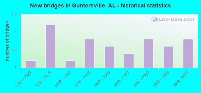
- New bridges - historical statistics
- 11920-1929
- 61930-1939
- 11940-1949
- 41950-1959
- 31960-1969
- 21970-1979
- 41980-1989
- 31990-1999
- 42000-2009

- Reconstructed bridges - Historical Statistics
- 31950-1959
- 11960-1969
- 11970-1979


- Bridge Condition - Deck
- 7.1%Excellent
- 14.3%Very good
- 42.9%Good
- 21.4%Satisfactory
- 7.1%Fair
- 7.1%Poor

- Bridge Condition - Superstructure
- 7.1%Excellent
- 14.3%Very good
- 50.0%Good
- 7.1%Satisfactory
- 21.4%Fair

- Bridge Condition - Substructure
- 7.7%Excellent
- 7.7%Very good
- 53.8%Good
- 15.4%Satisfactory
- 15.4%Fair

- Bridge Condition - Channel
- 3.6%Excellent
- 39.3%Very good
- 35.7%Good
- 21.4%Satisfactory

- Bridge Condition - Culverts
- 7.1%Very good
- 14.3%Good
- 78.6%Satisfactory
Find on map >> Show street view
Structure Number: 598, Location: 5.1 MI E JCT SR 77 (Lat: 33.603972, Lng: -86.024778), Route carried "on" structure: US 78, Year Built: 1929, Status: Open, Structure Length: 0.63m (2.07ft), Average Daily Traffic: 4,832 (year 2020), Truck Traffic: 3%, Average Future Daily Traffic: 6,765 (year 2040), Design Load: H 15, Features Intersected: PLUM SPRING BRANCH
Minimum Vertical Clearance: 30+ m (98+ ft), Kilometerpoint: 239.271, Lanes on structure: 2, Owner: State Highway Agency, Approaching Roadway Width: 8.5m (27.9ft), Material/Design: Concrete, Design/Construction: Culvert, Number Of Spans In Main Unit: 2, Length of Maximum Span: 3.0m (9.8ft)
Condition: Channel: Good, Culverts: Satisfactory, Operating Rating: 63.4 metric tons, Method Used To Determine Operating Rating: Load Factor (LF), Inventory Rating: 38.0 metric tons, Method Used To Determine Inventory Rating: Load Factor (LF), Structural Evaluation: Equal to present minimum criteria, Waterway Adequacy: Equal to present minimum criteria, Approach Roadway Alignment: Better than present minimum criteria, Length Of Structure Improvement: 1.25m (4.10ft), Designated Inspection Frequency: Every 24 months, Inspection Date: August 2021, Bridge Improvement Cost: $232,000, Roadway Improvement Cost: $23,000, Total Project Cost: $255,000 ( Estimate for 2022)
Find on map >> Show street view
Structure Number: 1484, Location: 0.6 MI N JCT US431 * SR79 (Lat: 34.431553, Lng: -86.255069), Route carried "on" structure: State highway 79, Year Built: 1936, Status: Open, Structure Length: 1.19m (3.90ft), Average Daily Traffic: 5,397 (year 2019), Truck Traffic: 11%, Average Future Daily Traffic: 7,556 (year 2039), Design Load: H 15, Features Intersected: SEIBOLD CREEK
Minimum Vertical Clearance: 30+ m (98+ ft), Kilometerpoint: 116.039, Lanes on structure: 2, Owner: State Highway Agency, Approaching Roadway Width: 9.8m (32.2ft), Material/Design: Concrete, Design/Construction: Culvert, Number Of Spans In Main Unit: 4, Length of Maximum Span: 3.0m (9.8ft)
Condition: Channel: Satisfactory, Culverts: Satisfactory, Operating Rating: 88.9 metric tons, Method Used To Determine Operating Rating: Load Factor (LF), Inventory Rating: 88.9 metric tons, Method Used To Determine Inventory Rating: Load Factor (LF), Structural Evaluation: Equal to present minimum criteria, Waterway Adequacy: Better than present minimum criteria, Approach Roadway Alignment: Equal to present desirable criteria, Length Of Structure Improvement: 1.86m (6.10ft), Designated Inspection Frequency: Every 24 months, Underwater Inspection Frequency: Every 24 months, Inspection Date: December 2020, Underwater Inspection Date: May 2020, Bridge Improvement Cost: $591,000, Roadway Improvement Cost: $59,000, Total Project Cost: $650,000 ( Estimate for 2022), Wearing Surface/Protective System: Wearing Surface: Bituminous
Find on map >> Show street view
Structure Number: 1835, Location: 1706 FT NW JCT 1291 (Lat: 34.263942, Lng: -86.333064), Route carried "on" structure: County highway 162, Year Built: 1962, Status: Open, Structure Length: 1.19m (3.90ft), Average Daily Traffic: 150 (year 1994), Truck Traffic: 1%, Average Future Daily Traffic: 300 (year 2040), Design Load: H 10, Features Intersected: HOG CREEK, Facility Carried by Structure: COUNTY HIGHWAY116
Minimum Vertical Clearance: 30+ m (98+ ft), Kilometerpoint: 0.010, Lanes on structure: 2, Owner: County Highway Agency, Approaching Roadway Width: 7.9m (25.9ft), Material/Design: Concrete, Design/Construction: Culvert, Number Of Spans In Main Unit: 3, Length of Maximum Span: 4.3m (14.1ft)
Condition: Channel: Very good, Culverts: Satisfactory, Operating Rating: 88.9 metric tons, Method Used To Determine Operating Rating: Load Factor (LF), Inventory Rating: 88.9 metric tons, Method Used To Determine Inventory Rating: Load Factor (LF), Structural Evaluation: Equal to present minimum criteria, Waterway Adequacy: Superior to present desirable criteria, Approach Roadway Alignment: Equal to present desirable criteria, Length Of Structure Improvement: 1.86m (6.10ft), Designated Inspection Frequency: Every 24 months, Inspection Date: September 2020, Bridge Improvement Cost: $387,000, Roadway Improvement Cost: $39,000, Total Project Cost: $426,000 ( Estimate for 2022), Wearing Surface/Protective System: Wearing Surface: Gravel
Find on map >> Show street view
Structure Number: 1862, Location: 4072 FT N JCT 1285 (Lat: 34.332911, Lng: -86.397511), Route carried "on" structure: County highway 283, Year Built: 1980, Status: Posted for load, Structure Length: 0.82m (2.69ft), Average Daily Traffic: 20 (year 1994), Average Future Daily Traffic: 25 (year 2040), Design Load: H 10, Features Intersected: BRANCH
Minimum Vertical Clearance: 30+ m (98+ ft), Kilometerpoint: 0.010, Lanes on structure: 1, Owner: County Highway Agency, Approaching Roadway Width: 7.3m (24.0ft), Material/Design: Steel, Design/Construction: Stringer/Multi-beam, Number Of Spans In Main Unit: 1, Length of Maximum Span: 7.8m (25.6ft), Curb-To-Curb Width: 4.9m (16.1ft), Out-to-Out Width: 4.9m (16.1ft)
Condition: Deck: Good, Superstructure: Good, Channel: Satisfactory, Operating Rating: 42.9 metric tons, Method Used To Determine Operating Rating: Allowable Stress (AS), Inventory Rating: 30.5 metric tons, Method Used To Determine Inventory Rating: Allowable Stress (AS), Structural Evaluation: Better than present minimum criteria, Deck Geometry: High priority of corrective action, Waterway Adequacy: Equal to present minimum criteria, Approach Roadway Alignment: Equal to present desirable criteria, Bridge Posting: Required (Relationship of Operating Rating to Maximum Legal Load: 10.0 - 19.9% below), Length Of Structure Improvement: 1.48m (4.86ft), Designated Inspection Frequency: Every 24 months, Other Special Inspection Frequency: Every 12 months, Inspection Date: June 2020, Other Special Inspection Date: June 2021, Bridge Improvement Cost: $162,000, Roadway Improvement Cost: $16,000, Total Project Cost: $178,000 ( Estimate for 2022), Deck Structure Type: Open Grating, Wearing Surface/Protective System: Wearing Surface: Other
Find on map >> Show street view
Structure Number: 1863, Location: 3755 FT N JCT 1464 (Lat: 34.271397, Lng: -86.322614), Route carried "on" structure: County highway 291, Year Built: 1938, Status: Posted for load, Structure Length: 0.82m (2.69ft), Average Daily Traffic: 50 (year 1994), Average Future Daily Traffic: 100 (year 2041), Design Load: H 10, Features Intersected: BRANCH
Minimum Vertical Clearance: 30+ m (98+ ft), Kilometerpoint: 0.010, Lanes on structure: 1, Owner: County Highway Agency, Approaching Roadway Width: 7.3m (24.0ft), Material/Design: Steel, Design/Construction: Stringer/Multi-beam, Number Of Spans In Main Unit: 1, Length of Maximum Span: 7.0m (23.0ft), Curb-To-Curb Width: 4.3m (14.1ft), Out-to-Out Width: 4.3m (14.1ft)
Condition: Deck: Poor, Superstructure: Fair, Substructure: Fair, Channel: Good, Operating Rating: 2.7 metric tons, Method Used To Determine Operating Rating: Load Factor (LF), Inventory Rating: 1.8 metric tons, Method Used To Determine Inventory Rating: Load Factor (LF), Structural Evaluation: High priority of replacement, Deck Geometry: Equal to present minimum criteria, Waterway Adequacy: Meets minimum limits, Approach Roadway Alignment: Somewhat better than minimum adequacy, Bridge Posting: Required (Relationship of Operating Rating to Maximum Legal Load: > 39.9% below), Length Of Structure Improvement: 1.48m (4.86ft), Designated Inspection Frequency: Every 24 months, Other Special Inspection Frequency: Every 12 months, Inspection Date: May 2021, Other Special Inspection Date: May 2021, Bridge Improvement Cost: $142,000, Roadway Improvement Cost: $14,000, Total Project Cost: $156,000 ( Estimate for 2022), Deck Structure Type: Wood or Timber, Wearing Surface/Protective System: Wearing Surface: Wood or Timber
Find on map >> Show street view
Structure Number: 4036, Location: 27568 FT S JCT 69 (Lat: 34.299325, Lng: -86.398242), Route carried "on" structure: County highway 14, Year Built: 1951, Status: Open, Structure Length: 1.56m (5.12ft), Average Daily Traffic: 2,360 (year 1999), Truck Traffic: 10%, Average Future Daily Traffic: 3,580 (year 2040), Design Load: H 10, Features Intersected: CREEK, Facility Carried by Structure: COUNTY HIGHWAY101
Minimum Vertical Clearance: 30+ m (98+ ft), Kilometerpoint: 0.010, Lanes on structure: 2, Owner: County Highway Agency, Approaching Roadway Width: 9.1m (29.9ft), Material/Design: Concrete, Design/Construction: Culvert, Number Of Spans In Main Unit: 4, Length of Maximum Span: 3.7m (12.1ft)
Condition: Channel: Very good, Culverts: Satisfactory, Operating Rating: 49.7 metric tons, Method Used To Determine Operating Rating: Load Factor (LF), Inventory Rating: 29.8 metric tons, Method Used To Determine Inventory Rating: Load Factor (LF), Structural Evaluation: Equal to present minimum criteria, Waterway Adequacy: Equal to present desirable criteria, Approach Roadway Alignment: Equal to present desirable criteria, Length Of Structure Improvement: 2.24m (7.35ft), Designated Inspection Frequency: Every 24 months, Inspection Date: April 2020, Bridge Improvement Cost: $376,000, Roadway Improvement Cost: $38,000, Total Project Cost: $414,000 ( Estimate for 2022), Wearing Surface/Protective System: Wearing Surface: Bituminous
Find on map >> Show street view
Structure Number: 4154, Location: 89 FT S JCT 1291 (Lat: 34.244569, Lng: -86.331444), Route carried "on" structure: County highway 162, Year Built: 1962, Status: Open, Structure Length: 1.19m (3.90ft), Average Daily Traffic: 200 (year 1994), Truck Traffic: 1%, Average Future Daily Traffic: 400 (year 2040), Design Load: H 10, Features Intersected: COLLINS CREEK, Facility Carried by Structure: COUNTY HIGHWAY116
Minimum Vertical Clearance: 30+ m (98+ ft), Kilometerpoint: 0.010, Lanes on structure: 2, Owner: County Highway Agency, Approaching Roadway Width: 9.1m (29.9ft), Skew: 1 degrees, Material/Design: Concrete, Design/Construction: Culvert, Number Of Spans In Main Unit: 3, Length of Maximum Span: 3.7m (12.1ft)
Condition: Channel: Very good, Culverts: Satisfactory, Operating Rating: 88.9 metric tons, Method Used To Determine Operating Rating: Load Factor (LF), Inventory Rating: 53.8 metric tons, Method Used To Determine Inventory Rating: Load Factor (LF), Structural Evaluation: Equal to present minimum criteria, Waterway Adequacy: Superior to present desirable criteria, Approach Roadway Alignment: Equal to present desirable criteria, Length Of Structure Improvement: 1.86m (6.10ft), Designated Inspection Frequency: Every 24 months, Inspection Date: September 2020, Bridge Improvement Cost: $452,000, Roadway Improvement Cost: $45,000, Total Project Cost: $497,000 ( Estimate for 2022), Wearing Surface/Protective System: Wearing Surface: Bituminous
Find on map >> Show street view
Structure Number: 4179, Location: 320 FT N JCT 1299 (Lat: 34.284900, Lng: -86.300900), Route carried "on" structure: County highway 300, Year Built: 1958, Status: Posted for load, Structure Length: 1.10m (3.61ft), Average Daily Traffic: 100 (year 1994), Average Future Daily Traffic: 250 (year 2040), Design Load: H 10, Features Intersected: HOG CREEK
Minimum Vertical Clearance: 30+ m (98+ ft), Kilometerpoint: 0.010, Lanes on structure: 2, Owner: County Highway Agency, Approaching Roadway Width: 7.9m (25.9ft), Material/Design: Steel, Design/Construction: Stringer/Multi-beam, Number Of Spans In Main Unit: 1, Length of Maximum Span: 10.1m (33.1ft), Curb-To-Curb Width: 5.6m (18.4ft), Out-to-Out Width: 6.2m (20.3ft)
Condition: Deck: Satisfactory, Superstructure: Fair, Substructure: Satisfactory, Channel: Good, Operating Rating: 21.3 metric tons, Method Used To Determine Operating Rating: Load Factor (LF), Inventory Rating: 12.4 metric tons, Method Used To Determine Inventory Rating: Load Factor (LF), Structural Evaluation: Meets minimum limits, Deck Geometry: Meets minimum limits, Waterway Adequacy: Better than present minimum criteria, Approach Roadway Alignment: Equal to present desirable criteria, Bridge Posting: Required (Relationship of Operating Rating to Maximum Legal Load: > 39.9% below), Length Of Structure Improvement: 1.77m (5.81ft), Designated Inspection Frequency: Every 24 months, Other Special Inspection Frequency: Every 12 months, Inspection Date: June 2020, Other Special Inspection Date: June 2021, Bridge Improvement Cost: $243,000, Roadway Improvement Cost: $24,000, Total Project Cost: $267,000 ( Estimate for 2022), Deck Structure Type: Concrete Cast-file-Place
Find on map >> Show street view
Structure Number: 4184, Location: 1145 FT S JCT 1513 (Lat: 34.364056, Lng: -86.167778), Route carried "on" structure: County highway 409, Year Built: 1951, Status: Open, Structure Length: 1.34m (4.40ft), Average Daily Traffic: 600 (year 1994), Truck Traffic: 1%, Average Future Daily Traffic: 1,000 (year 2040), Design Load: H 10, Features Intersected: DRY CREEK, Facility Carried by Structure: COUNTY HIGHWAY140
Minimum Vertical Clearance: 30+ m (98+ ft), Kilometerpoint: 0.010, Lanes on structure: 2, Owner: County Highway Agency, Approaching Roadway Width: 9.1m (29.9ft), Material/Design: Concrete, Design/Construction: Culvert, Number Of Spans In Main Unit: 4, Length of Maximum Span: 3.0m (9.8ft)
Condition: Channel: Good, Culverts: Satisfactory, Operating Rating: 54.2 metric tons, Method Used To Determine Operating Rating: Load Factor (LF), Inventory Rating: 32.5 metric tons, Method Used To Determine Inventory Rating: Load Factor (LF), Structural Evaluation: Equal to present minimum criteria, Waterway Adequacy: Superior to present desirable criteria, Approach Roadway Alignment: Equal to present desirable criteria, Length Of Structure Improvement: 2.02m (6.63ft), Designated Inspection Frequency: Every 24 months, Inspection Date: November 2020, Bridge Improvement Cost: $314,000, Roadway Improvement Cost: $31,000, Total Project Cost: $345,000 ( Estimate for 2022), Wearing Surface/Protective System: Wearing Surface: Gravel
Find on map >> Show street view
Structure Number: 598, Location: JCT SR 69 * BROWNS CREEK (Lat: 34.357331, Lng: -86.329675), Route carried "on" structure: State highway 69, Year Built: 1941, Year Reconstructed: 1957, Status: Open, Structure Length: 9.14m (29.99ft), Average Daily Traffic: 15,926 (year 2020), Truck Traffic: 9%, Average Future Daily Traffic: 22,296 (year 2040), Design Load: H 15, Features Intersected: BROWNS CREEK
Minimum Vertical Clearance: 30+ m (98+ ft), Kilometerpoint: 448.745, Lanes on structure: 4, Owner: State Highway Agency, Approaching Roadway Width: 21.9m (71.9ft), Skew: 20 degrees, Material/Design: Steel continuous, Design/Construction: Stringer/Multi-beam, Number Of Spans In Main Unit: 7, Length of Maximum Span: 16.5m (54.1ft), Curb or Sidewalk Widths: Left: 1.2m (3.9ft), Right: 1.2m (3.9ft), Curb-To-Curb Width: 17.0m (55.8ft), Out-to-Out Width: 20.1m (65.9ft)
Condition: Deck: Fair, Superstructure: Fair, Substructure: Fair, Channel: Satisfactory, Operating Rating: 46.4 metric tons, Method Used To Determine Operating Rating: Load Testing, Inventory Rating: 27.8 metric tons, Method Used To Determine Inventory Rating: Load Testing, Structural Evaluation: Somewhat better than minimum adequacy, Deck Geometry: Somewhat better than minimum adequacy, Waterway Adequacy: Equal to present minimum criteria, Approach Roadway Alignment: Somewhat better than minimum adequacy, Length Of Structure Improvement: 10.11m (33.17ft), Designated Inspection Frequency: Every 24 months, Underwater Inspection Frequency: Every 24 months, Inspection Date: March 2022, Underwater Inspection Date: May 2020, Bridge Improvement Cost: $4,504,000, Roadway Improvement Cost: $450,000, Total Project Cost: $4,954,000 ( Estimate for 2022), Deck Structure Type: Concrete Cast-file-Place
Find on map >> Show street view
Structure Number: 7208, Location: 2 MI S JCT US431 * SR227 (Lat: 34.346858, Lng: -86.273550), Route carried "on" structure: State highway 227, Year Built: 1938, Year Reconstructed: 1961, Status: Open, Structure Length: 4.05m (13.29ft), Average Daily Traffic: 10,635 (year 2019), Truck Traffic: 10%, Average Future Daily Traffic: 14,889 (year 2039), Design Load: H 20, Features Intersected: POLECAT CREEK
Minimum Vertical Clearance: 30+ m (98+ ft), Kilometerpoint: 60.333, Lanes on structure: 4, Owner: State Highway Agency, Approaching Roadway Width: 19.5m (64.0ft), Skew: 20 degrees, Material/Design: Steel continuous, Design/Construction: Stringer/Multi-beam, Number Of Spans In Main Unit: 3, Length of Maximum Span: 14.9m (48.9ft), Curb or Sidewalk Widths: Left: 0.5m (1.6ft), Right: 0.5m (1.6ft), Curb-To-Curb Width: 15.8m (51.8ft), Out-to-Out Width: 17.4m (57.1ft)
Condition: Deck: Good, Superstructure: Good, Substructure: Good, Channel: Satisfactory, Operating Rating: 37.3 metric tons, Method Used To Determine Operating Rating: Load Factor (LF), Inventory Rating: 22.3 metric tons, Method Used To Determine Inventory Rating: Load Factor (LF), Structural Evaluation: Somewhat better than minimum adequacy, Deck Geometry: Meets minimum limits, Waterway Adequacy: Equal to present minimum criteria, Approach Roadway Alignment: Equal to present minimum criteria, Length Of Structure Improvement: 5.01m (16.44ft), Designated Inspection Frequency: Every 24 months, Underwater Inspection Frequency: Every 24 months, Inspection Date: March 2021, Underwater Inspection Date: May 2020, Bridge Improvement Cost: $1,958,000, Roadway Improvement Cost: $196,000, Total Project Cost: $2,154,000 ( Estimate for 2022), Deck Structure Type: Concrete Cast-file-Place
Find on map >> Show street view
Structure Number: 7209, Location: 1 MI S JCT US431 * SR227 (Lat: 34.347089, Lng: -86.290575), Route carried "on" structure: State highway 227, Year Built: 1938, Year Reconstructed: 1961, Status: Open, Structure Length: 8.23m (27.00ft), Average Daily Traffic: 10,635 (year 2019), Truck Traffic: 10%, Average Future Daily Traffic: 14,889 (year 2039), Design Load: H 20, Features Intersected: BIG SPRING CREEK
Minimum Vertical Clearance: 30+ m (98+ ft), Kilometerpoint: 61.952, Lanes on structure: 4, Owner: State Highway Agency, Approaching Roadway Width: 18.9m (62.0ft), Skew: 20 degrees, Material/Design: Steel continuous, Design/Construction: Stringer/Multi-beam, Number Of Spans In Main Unit: 3, Length of Maximum Span: 29.9m (98.1ft), Curb or Sidewalk Widths: Left: 0.5m (1.6ft), Right: 0.5m (1.6ft), Curb-To-Curb Width: 15.8m (51.8ft), Out-to-Out Width: 17.4m (57.1ft)
Condition: Deck: Good, Superstructure: Good, Substructure: Good, Channel: Satisfactory, Operating Rating: 46.2 metric tons, Method Used To Determine Operating Rating: Load Factor (LF), Inventory Rating: 27.7 metric tons, Method Used To Determine Inventory Rating: Load Factor (LF), Structural Evaluation: Equal to present minimum criteria, Deck Geometry: Meets minimum limits, Waterway Adequacy: Equal to present minimum criteria, Approach Roadway Alignment: Equal to present minimum criteria, Length Of Structure Improvement: 9.23m (30.28ft), Designated Inspection Frequency: Every 24 months, Underwater Inspection Frequency: Every 24 months, Inspection Date: March 2021, Underwater Inspection Date: May 2020, Bridge Improvement Cost: $3,607,000, Roadway Improvement Cost: $361,000, Total Project Cost: $3,968,000 ( Estimate for 2022), Deck Structure Type: Concrete Cast-file-Place
Find on map >> Show street view
Structure Number: 11038, Location: 1.4 MI W BROWNS CREEK (Lat: 34.362508, Lng: -86.371103), Route carried "on" structure: State highway 69, Year Built: 1934, Year Reconstructed: 1974, Status: Open, Structure Length: 0.64m (2.10ft), Average Daily Traffic: 12,942 (year 2020), Truck Traffic: 9%, Average Future Daily Traffic: 18,119 (year 2040), Design Load: H 15, Features Intersected: BRANCH
Minimum Vertical Clearance: 30+ m (98+ ft), Kilometerpoint: 444.649, Lanes on structure: 4, Owner: State Highway Agency, Approaching Roadway Width: 14.6m (47.9ft), Material/Design: Masonry, Design/Construction: Culvert, Number Of Spans In Main Unit: 2, Length of Maximum Span: 3.0m (9.8ft)
Condition: Channel: Good, Culverts: Good, Operating Rating: 88.9 metric tons, Method Used To Determine Operating Rating: Load Factor (LF), Inventory Rating: 88.9 metric tons, Method Used To Determine Inventory Rating: Load Factor (LF), Structural Evaluation: Better than present minimum criteria, Waterway Adequacy: Equal to present minimum criteria, Approach Roadway Alignment: Better than present minimum criteria, Length Of Structure Improvement: 1.26m (4.13ft), Designated Inspection Frequency: Every 24 months, Inspection Date: September 2021, Bridge Improvement Cost: $1,114,000, Roadway Improvement Cost: $111,000, Total Project Cost: $1,225,000 ( Estimate for 2022), Wearing Surface/Protective System: Wearing Surface: Bituminous
Find on map >> Show street view
Structure Number: 11785, Location: CITY OF GUNTERSVILLE (Lat: 34.368003, Lng: -86.288928), Route carried "on" structure: US 431, Year Built: 1977, Status: Open, Structure Length: 86.96m (285.30ft), Average Daily Traffic: 16,869 (year 2019), Truck Traffic: 10%, Average Future Daily Traffic: 23,617 (year 2039), Design Load: HS 20, Features Intersected: TENNESSEE RIVER
Minimum Vertical Clearance: 30+ m (98+ ft), Kilometerpoint: 478.804, Lanes on structure: 2, Base Highway Network: Yes, Owner: State Highway Agency, Approaching Roadway Width: 12.2m (40.0ft), Skew: 10 degrees, Navigation Control: Yes ( Vertical Clearance: 17.4m (57.1ft), Horizontal Clearance: 106.7m (350.1ft)), Material/Design: Steel continuous, Design/Construction: Girder and Floorbeam System, Number Of Spans In Main Unit: 12, Number Of Approach Spans: 1, Length of Maximum Span: 114.3m (375.0ft), Curb-To-Curb Width: 12.0m (39.4ft), Out-to-Out Width: 12.8m (42.0ft)
Condition: Deck: Satisfactory, Superstructure: Satisfactory, Substructure: Satisfactory, Channel: Good, Operating Rating: 34.5 metric tons, Method Used To Determine Operating Rating: Load Factor (LF), Inventory Rating: 25.5 metric tons, Method Used To Determine Inventory Rating: Load Factor (LF), Structural Evaluation: Equal to present minimum criteria, Deck Geometry: Equal to present minimum criteria, Waterway Adequacy: Equal to present desirable criteria, Approach Roadway Alignment: Better than present minimum criteria, Length Of Structure Improvement: 86.96m (285.30ft), Designated Inspection Frequency: Every 24 months, Critical Feature Inspection Frequency: Every 24 months, Underwater Inspection Frequency: Every 24 months, Inspection Date: April 2021, Critical Feature Inspection Date: April 2021, Underwater Inspection Date: August 2021, Bridge Improvement Cost: $25,044,000, Roadway Improvement Cost: $2,504,000, Total Project Cost: $27,548,000 ( Estimate for 2022), Deck Structure Type: Concrete Cast-file-Place
Find on map >> Show street view
Structure Number: 12991, Location: 0.1 MI N JCT SR 227 (Lat: 34.440664, Lng: -86.169450), Route carried "on" structure: County highway 582, Year Built: 1983, Status: Open, Structure Length: 0.94m (3.08ft), Average Daily Traffic: 400 (year 2000), Truck Traffic: 1%, Average Future Daily Traffic: 480 (year 2040), Design Load: HS 20, Features Intersected: MINKEY CREEK, Facility Carried by Structure: RT. 1041
Minimum Vertical Clearance: 30+ m (98+ ft), Kilometerpoint: 0.010, Lanes on structure: 2, Owner: County Highway Agency, Approaching Roadway Width: 13.4m (44.0ft), Material/Design: Concrete, Design/Construction: Culvert, Number Of Spans In Main Unit: 3, Length of Maximum Span: 3.0m (9.8ft)
Condition: Channel: Good, Culverts: Satisfactory, Operating Rating: 57.0 metric tons, Method Used To Determine Operating Rating: Load Factor (LF), Inventory Rating: 34.2 metric tons, Method Used To Determine Inventory Rating: Load Factor (LF), Structural Evaluation: Equal to present minimum criteria, Waterway Adequacy: Superior to present desirable criteria, Approach Roadway Alignment: Equal to present desirable criteria, Length Of Structure Improvement: 1.61m (5.28ft), Designated Inspection Frequency: Every 24 months, Inspection Date: November 2020, Bridge Improvement Cost: $436,000, Roadway Improvement Cost: $44,000, Total Project Cost: $480,000 ( Estimate for 2022), Wearing Surface/Protective System: Wearing Surface: Bituminous
Find on map >> Show street view
Structure Number: 13087, Location: 0.6 MI N JCT SR79 * SR 1 (Lat: 34.433078, Lng: -86.263767), Route carried "on" structure: US 431, Year Built: 1930, Year Reconstructed: 1984, Status: Open, Structure Length: 0.64m (2.10ft), Average Daily Traffic: 12,048 (year 2019), Truck Traffic: 5%, Average Future Daily Traffic: 16,867 (year 2039), Design Load: HS 20, Features Intersected: BRANCH
Minimum Vertical Clearance: 30+ m (98+ ft), Kilometerpoint: 486.971, Lanes on structure: 4, Base Highway Network: Yes, Owner: State Highway Agency, Approaching Roadway Width: 14.6m (47.9ft), Material/Design: Concrete, Design/Construction: Culvert, Number Of Spans In Main Unit: 2, Length of Maximum Span: 3.0m (9.8ft)
Condition: Channel: Satisfactory, Culverts: Satisfactory, Operating Rating: 82.4 metric tons, Method Used To Determine Operating Rating: Load Factor (LF), Inventory Rating: 49.4 metric tons, Method Used To Determine Inventory Rating: Load Factor (LF), Structural Evaluation: Equal to present minimum criteria, Waterway Adequacy: Equal to present minimum criteria, Approach Roadway Alignment: Equal to present desirable criteria, Length Of Structure Improvement: 1.26m (4.13ft), Designated Inspection Frequency: Every 24 months, Inspection Date: November 2020, Bridge Improvement Cost: $1,063,000, Roadway Improvement Cost: $106,000, Total Project Cost: $1,169,000 ( Estimate for 2022), Wearing Surface/Protective System: Wearing Surface: Bituminous
Find on map >> Show street view
Structure Number: 13612, Location: SOUTH END OF WYETH DRIVE (Lat: 34.321744, Lng: -86.305233), Route carried "on" structure: City street , Year Built: 1985, Status: Open, Structure Length: 2.12m (6.96ft), Average Daily Traffic: 1,293 (year 2020), Truck Traffic: 2%, Average Future Daily Traffic: 1,484 (year 2040), Design Load: HS 20, Features Intersected: GUNTERSVILLE LAKE, Facility Carried by Structure: WYETH DR
Minimum Vertical Clearance: 30+ m (98+ ft), Kilometerpoint: 0.010, Lanes on structure: 2, Owner: City or Municipal Highway Agency, Approaching Roadway Width: 10.7m (35.1ft), Material/Design: Prestressed concrete, Design/Construction: Box Beam or Girders - Multiple, Number Of Spans In Main Unit: 1, Length of Maximum Span: 21.2m (69.6ft), Curb-To-Curb Width: 8.5m (27.9ft), Out-to-Out Width: 9.4m (30.8ft)
Condition: Deck: Good, Superstructure: Good, Substructure: Good, Channel: Good, Operating Rating: 60.2 metric tons, Method Used To Determine Operating Rating: Load Factor (LF), Inventory Rating: 36.1 metric tons, Method Used To Determine Inventory Rating: Load Factor (LF), Structural Evaluation: Better than present minimum criteria, Deck Geometry: Somewhat better than minimum adequacy, Waterway Adequacy: Better than present minimum criteria, Approach Roadway Alignment: Equal to present minimum criteria, Length Of Structure Improvement: 2.89m (9.48ft), Designated Inspection Frequency: Every 24 months, Inspection Date: October 2020, Bridge Improvement Cost: $595,000, Roadway Improvement Cost: $60,000, Total Project Cost: $655,000 ( Estimate for 2022), Deck Structure Type: Concrete Precast Panels, Wearing Surface/Protective System: Wearing Surface: Bituminous
Find on map >> Show street view
Structure Number: 14294, Location: 2980 FT NW JCT 1291 (Lat: 34.265303, Lng: -86.329406), Route carried "on" structure: County highway 464, Year Built: 1987, Status: Open, Structure Length: 0.79m (2.59ft), Average Daily Traffic: 200 (year 1994), Truck Traffic: 1%, Average Future Daily Traffic: 370 (year 2040), Design Load: HS 20, Features Intersected: HOG CREEK, Facility Carried by Structure: COUNTY HIGHWAY146
Minimum Vertical Clearance: 30+ m (98+ ft), Kilometerpoint: 0.010, Lanes on structure: 2, Owner: County Highway Agency, Approaching Roadway Width: 8.5m (27.9ft), Material/Design: Concrete, Design/Construction: Culvert, Number Of Spans In Main Unit: 2, Length of Maximum Span: 3.7m (12.1ft), Curb-To-Curb Width: 8.0m (26.2ft), Out-to-Out Width: 11.7m (38.4ft)
Condition: Channel: Very good, Culverts: Satisfactory, Operating Rating: 68.2 metric tons, Method Used To Determine Operating Rating: Load Factor (LF), Inventory Rating: 40.9 metric tons, Method Used To Determine Inventory Rating: Load Factor (LF), Structural Evaluation: Equal to present minimum criteria, Deck Geometry: Somewhat better than minimum adequacy, Waterway Adequacy: Equal to present desirable criteria, Approach Roadway Alignment: Meets minimum limits, Length Of Structure Improvement: 1.44m (4.72ft), Designated Inspection Frequency: Every 24 months, Inspection Date: June 2020, Bridge Improvement Cost: $333,000, Roadway Improvement Cost: $33,000, Total Project Cost: $366,000 ( Estimate for 2022), Wearing Surface/Protective System: Wearing Surface: Gravel
Find on map >> Show street view
Structure Number: 15972, Location: CITY OF GUNTERSVILLE (Lat: 34.368058, Lng: -86.289178), Route carried "on" structure: US 431, Year Built: 1994, Status: Open, Structure Length: 87.90m (288.39ft), Average Daily Traffic: 16,771 (year 2018), Truck Traffic: 10%, Average Future Daily Traffic: 23,471 (year 2038), Design Load: HS 20, Features Intersected: TENNESSEE RIVER
Minimum Vertical Clearance: 30+ m (98+ ft), Kilometerpoint: 478.804, Lanes on structure: 2, Base Highway Network: Yes, Owner: State Highway Agency, Approaching Roadway Width: 12.2m (40.0ft), Skew: 10 degrees, Navigation Control: Yes ( Vertical Clearance: 18.6m (61.0ft), Horizontal Clearance: 99.1m (325.1ft)), Material/Design: Steel continuous, Design/Construction: Stringer/Multi-beam, Number Of Spans In Main Unit: 6, Number Of Approach Spans: 10, Length of Maximum Span: 114.3m (375.0ft), Curb-To-Curb Width: 12.2m (40.0ft), Out-to-Out Width: 13.0m (42.7ft)
Condition: Deck: Satisfactory, Superstructure: Good, Substructure: Good, Channel: Very good, Operating Rating: 36.0 metric tons, Method Used To Determine Operating Rating: Load Factor (LF), Inventory Rating: 21.3 metric tons, Method Used To Determine Inventory Rating: Load Factor (LF), Structural Evaluation: Somewhat better than minimum adequacy, Deck Geometry: Better than present minimum criteria, Waterway Adequacy: Equal to present desirable criteria, Approach Roadway Alignment: Equal to present desirable criteria, Length Of Structure Improvement: 87.90m (288.39ft), Designated Inspection Frequency: Every 24 months, Underwater Inspection Frequency: Every 24 months, Inspection Date: May 2020, Underwater Inspection Date: August 2021, Bridge Improvement Cost: $25,315,000, Roadway Improvement Cost: $2,532,000, Total Project Cost: $27,847,000 ( Estimate for 2022), Deck Structure Type: Concrete Cast-file-Place
Find on map >> Show street view
Structure Number: 16147, Location: 17013 FT S JCT 69 (Lat: 34.323200, Lng: -86.379425), Route carried "on" structure: County highway 14, Year Built: 1993, Status: Open, Structure Length: 4.57m (14.99ft), Average Daily Traffic: 2,360 (year 1999), Truck Traffic: 10%, Average Future Daily Traffic: 3,380 (year 2040), Design Load: HS 20, Features Intersected: BEECH CREEK
Minimum Vertical Clearance: 30+ m (98+ ft), Kilometerpoint: 0.010, Lanes on structure: 2, Owner: County Highway Agency, Approaching Roadway Width: 12.2m (40.0ft), Material/Design: Prestressed concrete, Design/Construction: Stringer/Multi-beam, Number Of Spans In Main Unit: 3, Length of Maximum Span: 15.2m (49.9ft), Curb-To-Curb Width: 10.4m (34.1ft), Out-to-Out Width: 11.3m (37.1ft)
Condition: Deck: Very good, Superstructure: Very good, Substructure: Good, Channel: Excellent, Operating Rating: 48.4 metric tons, Method Used To Determine Operating Rating: Load Factor (LF), Inventory Rating: 29.0 metric tons, Method Used To Determine Inventory Rating: Load Factor (LF), Structural Evaluation: Better than present minimum criteria, Deck Geometry: Somewhat better than minimum adequacy, Waterway Adequacy: Superior to present desirable criteria, Approach Roadway Alignment: Equal to present desirable criteria, Length Of Structure Improvement: 5.56m (18.24ft), Designated Inspection Frequency: Every 24 months, Underwater Inspection Frequency: Every 48 months, Inspection Date: August 2020, Underwater Inspection Date: June 2021, Bridge Improvement Cost: $1,412,000, Roadway Improvement Cost: $141,000, Total Project Cost: $1,553,000 ( Estimate for 2022), Deck Structure Type: Concrete Cast-file-Place
Find on map >> Show street view
Structure Number: 16475, Location: 200' West int AL227/AL62 (Lat: 34.448333, Lng: -86.183333), Route carried "on" structure: US 62, Year Built: 1978, Status: Open, Structure Length: 1.34m (4.40ft), Average Daily Traffic: 210 (year 2020), Truck Traffic: 7%, Average Future Daily Traffic: 294 (year 2040), Design Load: HS 20, Features Intersected: BRANCH
Minimum Vertical Clearance: 7.56m (24.80ft), Kilometerpoint: 0.161, Lanes on structure: 4, Owner: State Highway Agency, Approaching Roadway Width: 21.3m (69.9ft), Skew: 4 degrees, Material/Design: Concrete continuous, Design/Construction: Culvert, Number Of Spans In Main Unit: 3, Length of Maximum Span: 4.3m (14.1ft)
Condition: Channel: Good, Culverts: Good, Operating Rating: 84.5 metric tons, Method Used To Determine Operating Rating: Load Factor (LF), Inventory Rating: 50.7 metric tons, Method Used To Determine Inventory Rating: Load Factor (LF), Structural Evaluation: Better than present minimum criteria, Waterway Adequacy: Equal to present desirable criteria, Approach Roadway Alignment: Equal to present desirable criteria, Length Of Structure Improvement: 2.02m (6.63ft), Designated Inspection Frequency: Every 24 months, Inspection Date: November 2021, Bridge Improvement Cost: $2,375,000, Roadway Improvement Cost: $238,000, Total Project Cost: $2,613,000 ( Estimate for 2022)
Find on map >> Show street view
Structure Number: 16478, Location: 0.50MI W CO RD 1014 (Lat: 34.309653, Lng: -86.404414), Route carried "on" structure: County highway 49, Year Built: 1969, Status: Open, Structure Length: 1.30m (4.27ft), Average Daily Traffic: 150 (year 1996), Truck Traffic: 1%, Average Future Daily Traffic: 400 (year 2040), Design Load: H 10, Features Intersected: MINK CREEK
Minimum Vertical Clearance: 30+ m (98+ ft), Kilometerpoint: 0.010, Lanes on structure: 2, Owner: County Highway Agency, Approaching Roadway Width: 7.9m (25.9ft), Material/Design: Concrete, Design/Construction: Culvert, Number Of Spans In Main Unit: 4, Length of Maximum Span: 3.0m (9.8ft)
Condition: Channel: Good, Culverts: Satisfactory, Operating Rating: 36.5 metric tons, Method Used To Determine Operating Rating: Load Factor (LF), Inventory Rating: 21.9 metric tons, Method Used To Determine Inventory Rating: Load Factor (LF), Structural Evaluation: Equal to present minimum criteria, Waterway Adequacy: Equal to present desirable criteria, Approach Roadway Alignment: Equal to present desirable criteria, Length Of Structure Improvement: 1.98m (6.50ft), Designated Inspection Frequency: Every 24 months, Inspection Date: April 2020, Bridge Improvement Cost: $388,000, Roadway Improvement Cost: $39,000, Total Project Cost: $427,000 ( Estimate for 2022), Wearing Surface/Protective System: Wearing Surface: Gravel
Find on map >> Show street view
Structure Number: 16634, Location: 300FT S CO RD 1483A (Lat: 34.435317, Lng: -86.262814), Route carried "on" structure: County highway 483, Year Built: 1996, Status: Open, Structure Length: 1.16m (3.81ft), Average Daily Traffic: 450 (year 1996), Truck Traffic: 70%, Average Future Daily Traffic: 500 (year 2042), Design Load: H 10, Features Intersected: CREEK
Minimum Vertical Clearance: 30+ m (98+ ft), Kilometerpoint: 0.010, Lanes on structure: 2, Owner: County Highway Agency, Approaching Roadway Width: 6.7m (22.0ft), Material/Design: Concrete, Design/Construction: Culvert, Number Of Spans In Main Unit: 4, Length of Maximum Span: 2.4m (7.9ft), Curb-To-Curb Width: 9.4m (30.8ft), Out-to-Out Width: 9.8m (32.2ft)
Condition: Channel: Very good, Culverts: Very good, Operating Rating: 88.9 metric tons, Method Used To Determine Operating Rating: Load Factor (LF), Inventory Rating: 88.9 metric tons, Method Used To Determine Inventory Rating: Load Factor (LF), Structural Evaluation: Equal to present desirable criteria, Deck Geometry: Equal to present minimum criteria, Waterway Adequacy: Superior to present desirable criteria, Approach Roadway Alignment: Superior to present desirable criteria, Length Of Structure Improvement: 1.84m (6.04ft), Designated Inspection Frequency: Every 24 months, Inspection Date: January 2022, Bridge Improvement Cost: $339,000, Roadway Improvement Cost: $34,000, Total Project Cost: $373,000 ( Estimate for 2022), Wearing Surface/Protective System: Wearing Surface: Gravel
Find on map >> Show street view
Structure Number: 1695, Location: 9MI S JCT US431 * SR227 (Lat: 34.403278, Lng: -86.177522), Route carried "on" structure: State highway 227, Year Built: 2000, Status: Open, Structure Length: 16.40m (53.81ft), Average Daily Traffic: 1,108 (year 2018), Truck Traffic: 6%, Average Future Daily Traffic: 1,551 (year 2038), Design Load: HS 20, Features Intersected: TOWN CREEK
Minimum Vertical Clearance: 30+ m (98+ ft), Kilometerpoint: 47.773, Lanes on structure: 2, Base Highway Network: Yes, Owner: State Highway Agency, Approaching Roadway Width: 11.9m (39.0ft), Material/Design: Prestressed concrete, Design/Construction: Stringer/Multi-beam, Number Of Spans In Main Unit: 4, Length of Maximum Span: 41.0m (134.5ft), Curb-To-Curb Width: 11.9m (39.0ft), Out-to-Out Width: 12.8m (42.0ft)
Condition: Deck: Good, Superstructure: Good, Substructure: Good, Channel: Very good, Operating Rating: 87.4 metric tons, Method Used To Determine Operating Rating: Load Factor (LF), Inventory Rating: 45.0 metric tons, Method Used To Determine Inventory Rating: Load Factor (LF), Structural Evaluation: Better than present minimum criteria, Deck Geometry: Equal to present minimum criteria, Waterway Adequacy: Better than present minimum criteria, Approach Roadway Alignment: Better than present minimum criteria, Length Of Structure Improvement: 17.14m (56.23ft), Designated Inspection Frequency: Every 24 months, Underwater Inspection Frequency: Every 24 months, Inspection Date: April 2020, Underwater Inspection Date: July 2021, Bridge Improvement Cost: $4,937,000, Roadway Improvement Cost: $494,000, Total Project Cost: $5,431,000 ( Estimate for 2022), Deck Structure Type: Concrete Cast-file-Place
Find on map >> Show street view
Structure Number: 17306, Location: 6 MI S JCT US431 * SR227 (Lat: 34.368333, Lng: -86.221667), Route carried "on" structure: State highway 227, Year Built: 2000, Status: Open, Structure Length: 9.54m (31.30ft), Average Daily Traffic: 2,557 (year 2018), Truck Traffic: 6%, Average Future Daily Traffic: 3,579 (year 2038), Design Load: HS 20, Features Intersected: SHORT CREEK
Minimum Vertical Clearance: 30+ m (98+ ft), Kilometerpoint: 53.899, Lanes on structure: 2, Owner: State Highway Agency, Approaching Roadway Width: 12.0m (39.4ft), Material/Design: Prestressed concrete, Design/Construction: Stringer/Multi-beam, Number Of Spans In Main Unit: 3, Length of Maximum Span: 31.8m (104.3ft), Curb-To-Curb Width: 12.0m (39.4ft), Out-to-Out Width: 12.8m (42.0ft)
Condition: Deck: Good, Superstructure: Good, Substructure: Good, Channel: Very good, Operating Rating: 61.8 metric tons, Method Used To Determine Operating Rating: Load Factor (LF), Inventory Rating: 38.3 metric tons, Method Used To Determine Inventory Rating: Load Factor (LF), Structural Evaluation: Better than present minimum criteria, Deck Geometry: Somewhat better than minimum adequacy, Waterway Adequacy: Better than present minimum criteria, Approach Roadway Alignment: Equal to present desirable criteria, Length Of Structure Improvement: 10.49m (34.42ft), Designated Inspection Frequency: Every 24 months, Underwater Inspection Frequency: Every 24 months, Inspection Date: April 2020, Underwater Inspection Date: July 2021, Bridge Improvement Cost: $3,021,000, Roadway Improvement Cost: $302,000, Total Project Cost: $3,323,000 ( Estimate for 2022), Deck Structure Type: Concrete Cast-file-Place
Find on map >> Show street view
Structure Number: 17489, Location: 4,572 FT S JCT 69 (Lat: 34.353003, Lng: -86.361014), Route carried "on" structure: County highway 14, Year Built: 1954, Status: Open, Structure Length: 0.65m (2.13ft), Average Daily Traffic: 2,360 (year 1999), Average Future Daily Traffic: 2,880 (year 2040), Design Load: H 10, Features Intersected: SMITH SPRING
Minimum Vertical Clearance: 30+ m (98+ ft), Kilometerpoint: 1.392, Lanes on structure: 2, Owner: County Highway Agency, Approaching Roadway Width: 9.1m (29.9ft), Material/Design: Concrete, Design/Construction: Culvert, Number Of Spans In Main Unit: 2, Length of Maximum Span: 3.1m (10.2ft)
Condition: Channel: Very good, Culverts: Satisfactory, Operating Rating: 41.0 metric tons, Method Used To Determine Operating Rating: Load Factor (LF), Inventory Rating: 24.6 metric tons, Method Used To Determine Inventory Rating: Load Factor (LF), Structural Evaluation: Equal to present minimum criteria, Waterway Adequacy: Superior to present desirable criteria, Approach Roadway Alignment: Equal to present desirable criteria, Length Of Structure Improvement: 1.27m (4.17ft), Designated Inspection Frequency: Every 24 months, Inspection Date: April 2020, Bridge Improvement Cost: $154,000, Roadway Improvement Cost: $15,000, Total Project Cost: $169,000 ( Estimate for 2022), Wearing Surface/Protective System: Wearing Surface: Bituminous
Find on map >> Show street view
Structure Number: 18563, Location: 086D 19M 54.00000S (Lat: 34.258119, Lng: -86.330758), Route carried "on" structure: County highway 166, Year Built: 2003, Status: Open, Structure Length: 2.13m (6.99ft), Average Daily Traffic: 266 (year 2002), Truck Traffic: 1%, Average Future Daily Traffic: 400 (year 2040), Design Load: HS 20, Features Intersected: COUNTY HWY 166, Facility Carried by Structure: 3767 FT W JCT 1464
Minimum Vertical Clearance: 30+ m (98+ ft), Kilometerpoint: 0.010, Lanes on structure: 2, Owner: County Highway Agency, Approaching Roadway Width: 7.9m (25.9ft), Material/Design: Prestressed concrete, Design/Construction: Stringer/Multi-beam, Number Of Spans In Main Unit: 1, Length of Maximum Span: 20.9m (68.6ft), Curb-To-Curb Width: 8.5m (27.9ft), Out-to-Out Width: 9.4m (30.8ft)
Condition: Deck: Excellent, Superstructure: Excellent, Substructure: Excellent, Channel: Very good, Operating Rating: 33.6 metric tons, Method Used To Determine Operating Rating: Load Factor (LF), Inventory Rating: 20.0 metric tons, Method Used To Determine Inventory Rating: Load Factor (LF), Structural Evaluation: Somewhat better than minimum adequacy, Deck Geometry: Equal to present minimum criteria, Waterway Adequacy: Superior to present desirable criteria, Approach Roadway Alignment: Equal to present desirable criteria, Length Of Structure Improvement: 2.92m (9.58ft), Designated Inspection Frequency: Every 24 months, Inspection Date: September 2020, Bridge Improvement Cost: $600,000, Roadway Improvement Cost: $60,000, Total Project Cost: $660,000 ( Estimate for 2022), Deck Structure Type: Concrete Cast-file-Place, Wearing Surface/Protective System: Deck Protection: Epoxy Coated Reinforcing
Find on map >> Show street view
Structure Number: 18656, Location: 4817 FT E JCT 1014 (Lat: 34.284453, Lng: -86.388414), Route carried "on" structure: County highway 176, Year Built: 2004, Status: Open, Structure Length: 6.10m (20.01ft), Average Daily Traffic: 510 (year 1994), Truck Traffic: 1%, Average Future Daily Traffic: 525 (year 2040), Design Load: HS 20, Features Intersected: BROWN'S CREEK
Minimum Vertical Clearance: 30+ m (98+ ft), Kilometerpoint: 0.010, Lanes on structure: 2, Owner: County Highway Agency, Approaching Roadway Width: 8.5m (27.9ft), Material/Design: Prestressed concrete, Design/Construction: Stringer/Multi-beam, Number Of Spans In Main Unit: 2, Length of Maximum Span: 12.2m (40.0ft), Curb-To-Curb Width: 8.5m (27.9ft), Out-to-Out Width: 9.4m (30.8ft)
Condition: Deck: Very good, Superstructure: Very good, Substructure: Very good, Channel: Very good, Operating Rating: 65.0 metric tons, Method Used To Determine Operating Rating: Load Factor (LF), Inventory Rating: 39.0 metric tons, Method Used To Determine Inventory Rating: Load Factor (LF), Structural Evaluation: Equal to present desirable criteria, Deck Geometry: Somewhat better than minimum adequacy, Waterway Adequacy: Superior to present desirable criteria, Approach Roadway Alignment: Equal to present desirable criteria, Length Of Structure Improvement: 7.14m (23.43ft), Designated Inspection Frequency: Every 24 months, Inspection Date: April 2020, Bridge Improvement Cost: $1,468,000, Roadway Improvement Cost: $147,000, Total Project Cost: $1,615,000 ( Estimate for 2022), Deck Structure Type: Concrete Cast-file-Place