Bridge Statistics for Groveland, Florida (FL)
Condition, Traffic, Stress, Structural Evaluation, Project Costs
- National Bridge Inventory (NBI) Statistics
- 18Number of bridges
- 180ft / 54.9mTotal length
- $260,000Total costs
- 337,170Total average daily traffic
- 57,937Total average daily truck traffic
- National Bridge Inventory (NBI) Registered Bridges for Groveland
- No street view available for this location
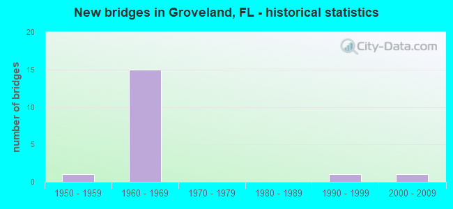
- New bridges - historical statistics
- 11950-1959
- 151960-1969
- 11990-1999
- 12000-2009

- Reconstructed bridges - Historical Statistics
- 11970-1979
- 11980-1989
- 21990-1999


- Bridge Condition - Deck
- 80.0%Good
- 20.0%Satisfactory

- Bridge Condition - Superstructure
- 10.0%Very good
- 40.0%Good
- 50.0%Satisfactory

- Bridge Condition - Substructure
- 10.0%Very good
- 90.0%Good

- Bridge Condition - Channel
- 50.0%Very good
- 50.0%Good
Find on map >> Show street view
Structure Number: 110012, Location: 0.6 MI S OF EXIT 285 (Lat: 28.647975, Lng: -81.799972), Route carried "on" structure: State highway 91, Year Built: 1963, Status: Open, Structure Length: 3.92m (12.86ft), Average Daily Traffic: 27,750 (year 2020), Truck Traffic: 21%, Average Future Daily Traffic: 48,146 (year 2042), Design Load: HS 20, Features Intersected: SR 19
Minimum Vertical Clearance: 30+ m (98+ ft), Kilometerpoint: 17.859, Lanes on structure: 2, Lanes under structure: 2, Base Highway Network: Yes, Toll: On toll road, Owner: State Toll Authority, Approaching Roadway Width: 11.7m (38.4ft), Skew: 1 degrees, Material/Design: Prestressed concrete, Design/Construction: Stringer/Multi-beam, Number Of Spans In Main Unit: 3, Length of Maximum Span: 14.9m (48.9ft), Curb-To-Curb Width: 11.6m (38.1ft), Out-to-Out Width: 13.4m (44.0ft)
Condition: Deck: Good, Superstructure: Good, Substructure: Good, Operating Rating: 50.3 metric tons, Method Used To Determine Operating Rating: Load and Resistance Factor (LRFR), Inventory Rating: 38.8 metric tons, Method Used To Determine Inventory Rating: Load and Resistance Factor (LRFR), Structural Evaluation: Better than present minimum criteria, Deck Geometry: Equal to present minimum criteria, Underclear: Meets minimum limits, Approach Roadway Alignment: Equal to present desirable criteria, Designated Inspection Frequency: Every 24 months, Inspection Date: October 2021, Deck Structure Type: Concrete Cast-file-Place
Find on map >> Show street view
Structure Number: 110017, Location: US-27 SB - SR-19 (Lat: 28.642394, Lng: -81.806878), Route carried "on" structure: US 25, Year Built: 1964, Year Reconstructed: 2002, Status: Open, Structure Length: 6.58m (21.59ft), Average Daily Traffic: 9,800 (year 2020), Truck Traffic: 12%, Average Future Daily Traffic: 17,003 (year 2042), Design Load: HS 20, Features Intersected: SR-19, Facility Carried by Structure: US-27 SB
Minimum Vertical Clearance: 30+ m (98+ ft), Kilometerpoint: 37.580, Lanes on structure: 3, Lanes under structure: 2, Base Highway Network: Yes, Owner: State Highway Agency, Approaching Roadway Width: 13.3m (43.6ft), Skew: 3 degrees, Material/Design: Prestressed concrete, Design/Construction: Stringer/Multi-beam, Number Of Spans In Main Unit: 3, Length of Maximum Span: 21.7m (71.2ft), Curb-To-Curb Width: 13.1m (43.0ft), Out-to-Out Width: 13.7m (44.9ft)
Condition: Deck: Good, Superstructure: Satisfactory, Substructure: Good, Operating Rating: 51.5 metric tons, Method Used To Determine Operating Rating: Load Factor (LF), Inventory Rating: 31.6 metric tons, Method Used To Determine Inventory Rating: Load Factor (LF), Structural Evaluation: Equal to present minimum criteria, Deck Geometry: Meets minimum limits, Underclear: Equal to present minimum criteria, Approach Roadway Alignment: Equal to present desirable criteria, Designated Inspection Frequency: Every 24 months, Inspection Date: October 2020, Deck Structure Type: Concrete Cast-file-Place, Wearing Surface/Protective System: Wearing Surface: Bituminous
Find on map >> Show street view
Structure Number: 110027, Location: SR-50 - Palatlakaha Cr. (Lat: 28.555967, Lng: -81.783478), Route carried "on" structure: State highway 50, Year Built: 1952, Year Reconstructed: 1982, Status: Open, Structure Length: 4.63m (15.19ft), Average Daily Traffic: 29,000 (year 2020), Truck Traffic: 8%, Average Future Daily Traffic: 50,315 (year 2042), Design Load: H 15, Features Intersected: Palatlakaha Creek
Minimum Vertical Clearance: 30+ m (98+ ft), Kilometerpoint: 17.555, Lanes on structure: 4, Owner: State Highway Agency, Approaching Roadway Width: 17.1m (56.1ft), Skew: 20 degrees, Material/Design: Concrete, Design/Construction: Slab, Number Of Spans In Main Unit: 6, Length of Maximum Span: 7.6m (24.9ft), Curb-To-Curb Width: 21.6m (70.9ft), Out-to-Out Width: 28.8m (94.5ft)
Condition: Deck: Satisfactory, Superstructure: Satisfactory, Substructure: Good, Channel: Good, Operating Rating: 54.4 metric tons, Method Used To Determine Operating Rating: Load Testing, Inventory Rating: 32.7 metric tons, Method Used To Determine Inventory Rating: Load Testing, Structural Evaluation: Equal to present minimum criteria, Deck Geometry: Superior to present desirable criteria, Waterway Adequacy: Equal to present desirable criteria, Approach Roadway Alignment: Equal to present desirable criteria, Length Of Structure Improvement: 2.50m (8.20ft), Designated Inspection Frequency: Every 24 months, Underwater Inspection Frequency: Every 24 months, Inspection Date: May 2021, Underwater Inspection Date: May 2021, Bridge Improvement Cost: $95,000, Total Project Cost: $125,000, Deck Structure Type: Concrete Cast-file-Place, Wearing Surface/Protective System: Wearing Surface: Monolithic Concrete
Find on map >> Show street view
Structure Number: 110064, Location: US-27 NB - SR-19 (Lat: 28.642578, Lng: -81.806731), Route carried "on" structure: US 27, Year Built: 1964, Year Reconstructed: 2002, Status: Open, Structure Length: 6.58m (21.59ft), Average Daily Traffic: 9,800 (year 2020), Truck Traffic: 12%, Average Future Daily Traffic: 17,003 (year 2042), Design Load: HS 20, Features Intersected: SR-19
Minimum Vertical Clearance: 30+ m (98+ ft), Kilometerpoint: 37.564, Lanes on structure: 3, Lanes under structure: 2, Base Highway Network: Yes, Owner: State Highway Agency, Approaching Roadway Width: 14.3m (46.9ft), Skew: 3 degrees, Material/Design: Prestressed concrete, Design/Construction: Stringer/Multi-beam, Number Of Spans In Main Unit: 3, Length of Maximum Span: 21.7m (71.2ft), Curb-To-Curb Width: 13.2m (43.3ft), Out-to-Out Width: 13.8m (45.3ft)
Condition: Deck: Good, Superstructure: Good, Substructure: Good, Operating Rating: 51.5 metric tons, Method Used To Determine Operating Rating: Load Factor (LF), Inventory Rating: 31.6 metric tons, Method Used To Determine Inventory Rating: Load Factor (LF), Structural Evaluation: Better than present minimum criteria, Deck Geometry: Somewhat better than minimum adequacy, Underclear: Equal to present minimum criteria, Approach Roadway Alignment: Equal to present desirable criteria, Designated Inspection Frequency: Every 24 months, Inspection Date: October 2020, Deck Structure Type: Concrete Cast-file-Place, Wearing Surface/Protective System: Wearing Surface: Bituminous
Find on map >> Show street view
Structure Number: 110068, Location: 0.5 MI NORTH OF SR 19 (Lat: 28.651819, Lng: -81.807006), Route carried "on" structure: Ramp State highway 91, Year Built: 1964, Status: Open, Structure Length: 5.89m (19.32ft), Average Daily Traffic: 6,000 (year 2020), Truck Traffic: 21%, Average Future Daily Traffic: 10,410 (year 2042), Design Load: HS 20, Features Intersected: SR 91 TPK LEESBURG INT
Minimum Vertical Clearance: 30+ m (98+ ft), Kilometerpoint: 0.460, Lanes on structure: 1, Lanes under structure: 4, Toll: On toll road, Owner: State Toll Authority, Approaching Roadway Width: 11.0m (36.1ft), Material/Design: Prestressed concrete, Design/Construction: Stringer/Multi-beam, Number Of Spans In Main Unit: 4, Length of Maximum Span: 20.7m (67.9ft), Curb-To-Curb Width: 11.6m (38.1ft), Out-to-Out Width: 13.4m (44.0ft)
Condition: Deck: Good, Superstructure: Satisfactory, Substructure: Good, Operating Rating: 52.3 metric tons, Method Used To Determine Operating Rating: Load Factor (LF), Inventory Rating: 31.3 metric tons, Method Used To Determine Inventory Rating: Load Factor (LF), Structural Evaluation: Equal to present minimum criteria, Deck Geometry: Superior to present desirable criteria, Underclear: Meets minimum limits, Approach Roadway Alignment: Equal to present desirable criteria, Designated Inspection Frequency: Every 24 months, Inspection Date: October 2021, Deck Structure Type: Concrete Cast-file-Place, Wearing Surface/Protective System: Wearing Surface: Bituminous
Find on map >> Show street view
Structure Number: 110071, Location: 0.6 MI S OF EXIT 285 (Lat: 28.648100, Lng: -81.799819), Route carried "on" structure: State highway 91, Year Built: 1964, Status: Open, Structure Length: 3.92m (12.86ft), Average Daily Traffic: 27,750 (year 2020), Truck Traffic: 21%, Average Future Daily Traffic: 48,146 (year 2042), Design Load: HS 20+Mod, Features Intersected: SR 19
Minimum Vertical Clearance: 30+ m (98+ ft), Kilometerpoint: 17.852, Lanes on structure: 2, Lanes under structure: 2, Base Highway Network: Yes, Toll: On toll road, Owner: State Toll Authority, Approaching Roadway Width: 11.7m (38.4ft), Skew: 1 degrees, Material/Design: Prestressed concrete, Design/Construction: Stringer/Multi-beam, Number Of Spans In Main Unit: 3, Length of Maximum Span: 14.9m (48.9ft), Curb-To-Curb Width: 11.6m (38.1ft), Out-to-Out Width: 13.4m (44.0ft)
Condition: Deck: Good, Superstructure: Satisfactory, Substructure: Good, Operating Rating: 54.2 metric tons, Method Used To Determine Operating Rating: Load and Resistance Factor (LRFR), Inventory Rating: 41.8 metric tons, Method Used To Determine Inventory Rating: Load and Resistance Factor (LRFR), Structural Evaluation: Equal to present minimum criteria, Deck Geometry: Better than present minimum criteria, Underclear: Meets minimum limits, Approach Roadway Alignment: Equal to present desirable criteria, Designated Inspection Frequency: Every 24 months, Inspection Date: October 2021, Deck Structure Type: Concrete Cast-file-Place
Find on map >> Show street view
Structure Number: 110072, Location: 0.3MI N OF LEESBURG INTER (Lat: 28.654233, Lng: -81.811661), Route carried "on" structure: City street , Year Built: 1962, Status: Open, Structure Length: 6.00m (19.69ft), Average Daily Traffic: 1,210 (year 2005), Truck Traffic: 5%, Average Future Daily Traffic: 2,700 (year 2035), Design Load: H 20, Features Intersected: SR 91 TPK, Facility Carried by Structure: OBRIEN RD 285.9
Minimum Vertical Clearance: 30+ m (98+ ft), Kilometerpoint: 2.054, Lanes on structure: 2, Lanes under structure: 4, Owner: State Toll Authority, Approaching Roadway Width: 6.4m (21.0ft), Skew: 2 degrees, Material/Design: Prestressed concrete, Design/Construction: Stringer/Multi-beam, Number Of Spans In Main Unit: 4, Length of Maximum Span: 18.1m (59.4ft), Curb-To-Curb Width: 8.5m (27.9ft), Out-to-Out Width: 10.3m (33.8ft)
Condition: Deck: Good, Superstructure: Very good, Substructure: Good, Operating Rating: 44.9 metric tons, Method Used To Determine Operating Rating: Load Factor (LF), Inventory Rating: 28.8 metric tons, Method Used To Determine Inventory Rating: Load Factor (LF), Structural Evaluation: Better than present minimum criteria, Deck Geometry: Somewhat better than minimum adequacy, Underclear: Meets minimum limits, Approach Roadway Alignment: Better than present minimum criteria, Designated Inspection Frequency: Every 24 months, Inspection Date: October 2021, Deck Structure Type: Concrete Cast-file-Place
Find on map >> Show street view
Structure Number: 110073, Location: 3.7 MI N OF SR 19 (Lat: 28.675436, Lng: -81.853278), Route carried "on" structure: State highway 91, Year Built: 1964, Year Reconstructed: 1991, Status: Open, Structure Length: 6.31m (20.70ft), Average Daily Traffic: 23,500 (year 2020), Truck Traffic: 21%, Average Future Daily Traffic: 40,772 (year 2042), Design Load: H 20, Features Intersected: US 27 SR 25 CLERMT INT
Minimum Vertical Clearance: 30+ m (98+ ft), Kilometerpoint: 23.875, Lanes on structure: 2, Lanes under structure: 5, Base Highway Network: Yes, Toll: On toll road, Owner: State Toll Authority, Approaching Roadway Width: 12.7m (41.7ft), Skew: 3 degrees, Material/Design: Prestressed concrete, Design/Construction: Stringer/Multi-beam, Number Of Spans In Main Unit: 4, Length of Maximum Span: 16.8m (55.1ft), Curb-To-Curb Width: 12.2m (40.0ft), Out-to-Out Width: 13.2m (43.3ft)
Condition: Deck: Satisfactory, Superstructure: Satisfactory, Substructure: Good, Operating Rating: 40.2 metric tons, Method Used To Determine Operating Rating: Load and Resistance Factor (LRFR), Inventory Rating: 31.0 metric tons, Method Used To Determine Inventory Rating: Load and Resistance Factor (LRFR), Structural Evaluation: Equal to present minimum criteria, Deck Geometry: Better than present minimum criteria, Underclear: Meets minimum limits, Approach Roadway Alignment: Equal to present desirable criteria, Designated Inspection Frequency: Every 24 months, Inspection Date: October 2021, Deck Structure Type: Concrete Cast-file-Place
Find on map >> Show street view
Structure Number: 110083, Location: SR-19 - Palatlakaha Creek (Lat: 28.579978, Lng: -81.855625), Route carried "on" structure: State highway 19, Year Built: 2000, Status: Open, Structure Length: 4.48m (14.70ft), Average Daily Traffic: 12,500 (year 2020), Truck Traffic: 27%, Average Future Daily Traffic: 21,688 (year 2042), Design Load: HS 25 or greater, Features Intersected: Palatlakaha Creek
Minimum Vertical Clearance: 30+ m (98+ ft), Kilometerpoint: 2.126, Lanes on structure: 2, Owner: State Highway Agency, Approaching Roadway Width: 10.6m (34.8ft), Skew: 2 degrees, Material/Design: Concrete continuous, Design/Construction: Slab, Number Of Spans In Main Unit: 5, Length of Maximum Span: 8.8m (28.9ft), Curb-To-Curb Width: 13.3m (43.6ft), Out-to-Out Width: 14.3m (46.9ft)
Condition: Deck: Good, Superstructure: Good, Substructure: Good, Channel: Very good, Operating Rating: 49.4 metric tons, Method Used To Determine Operating Rating: Load and Resistance Factor (LRFR), Inventory Rating: 38.1 metric tons, Method Used To Determine Inventory Rating: Load and Resistance Factor (LRFR), Structural Evaluation: Better than present minimum criteria, Deck Geometry: Somewhat better than minimum adequacy, Waterway Adequacy: Better than present minimum criteria, Approach Roadway Alignment: Equal to present desirable criteria, Designated Inspection Frequency: Every 24 months, Underwater Inspection Frequency: Every 24 months, Inspection Date: January 2022, Underwater Inspection Date: January 2022, Deck Structure Type: Concrete Cast-file-Place, Wearing Surface/Protective System: Wearing Surface: Bituminous, Deck Protection: Other Coated Reinforcing
Find on map >> Show street view
Structure Number: 18007, Location: I-75 SB over SR-44 (Lat: 28.873600, Lng: -82.092564), Route carried "on" structure: Interstate 75, Year Built: 1994, Status: Open, Structure Length: 6.58m (21.59ft), Average Daily Traffic: 37,250 (year 2018), Truck Traffic: 22%, Average Future Daily Traffic: 64,629 (year 2040), Design Load: HS 20+Mod, Features Intersected: SR-44
Minimum Vertical Clearance: 30+ m (98+ ft), Kilometerpoint: 36.382, Lanes on structure: 3, Lanes under structure: 8, Base Highway Network: Yes, Owner: State Highway Agency, Approaching Roadway Width: 17.0m (55.8ft), Skew: 3 degrees, Material/Design: Prestressed concrete, Design/Construction: Stringer/Multi-beam, Number Of Spans In Main Unit: 2, Length of Maximum Span: 32.9m (107.9ft), Curb-To-Curb Width: 17.0m (55.8ft), Out-to-Out Width: 17.4m (57.1ft)
Condition: Deck: Good, Superstructure: Good, Substructure: Very good, Inventory Rating: 59.7 metric tons, Method Used To Determine Inventory Rating: Load Factor (LF), Structural Evaluation: Better than present minimum criteria, Deck Geometry: Equal to present minimum criteria, Underclear: Meets minimum limits, Approach Roadway Alignment: Equal to present desirable criteria, Length Of Structure Improvement: 6.58m (21.59ft), Designated Inspection Frequency: Every 24 months, Inspection Date: Febuary 2021, Bridge Improvement Cost: $53,000, Total Project Cost: $135,000, Deck Structure Type: Concrete Cast-file-Place
Find on map >> Show street view
Structure Number: 110012, Location: 0.6 MI S OF EXIT 285 (Lat: 28.647975, Lng: -81.799972), Route carried "under" structure: State highway 19, Year Built: 1963, Structure Length: 0. m, Average Daily Traffic: 10,500 (year 2020), Truck Traffic: 10%, Features Intersected: SR 19, Facility Carried by Structure: SR 91 TPK SB 285.1
Minimum Vertical Clearance: 4.63m (15.19ft), Kilometerpoint: 11.555, Lanes on structure: 2, Lanes under structure: 2, Material/Design: Prestressed concrete, Design/Construction: Stringer/Multi-beam, Length of Maximum Span: 14.9m (48.9ft)
Find on map >> Show street view
Structure Number: 110017, Location: US-27 SB - SR-19 (Lat: 28.642394, Lng: -81.806878), Route carried "under" structure: State highway 19, Year Built: 1964, Structure Length: 0. m, Average Daily Traffic: 10,500 (year 2020), Truck Traffic: 10%, Features Intersected: SR-19, Facility Carried by Structure: US-27 SB
Minimum Vertical Clearance: 4.94m (16.21ft), Kilometerpoint: 10.649, Lanes on structure: 3, Lanes under structure: 2, Material/Design: Prestressed concrete, Design/Construction: Stringer/Multi-beam, Length of Maximum Span: 21.7m (71.2ft)
Find on map >> Show street view
Structure Number: 110064, Location: US-27 NB - SR-19 (Lat: 28.642578, Lng: -81.806731), Route carried "under" structure: State highway 19, Year Built: 1964, Structure Length: 0. m, Average Daily Traffic: 10,500 (year 2020), Truck Traffic: 10%, Features Intersected: SR-19, Facility Carried by Structure: US-27 NB
Minimum Vertical Clearance: 4.66m (15.29ft), Kilometerpoint: 10.672, Lanes on structure: 3, Lanes under structure: 2, Material/Design: Prestressed concrete, Design/Construction: Stringer/Multi-beam, Length of Maximum Span: 21.7m (71.2ft)
Find on map >> Show street view
Structure Number: 110068, Location: 0.5 MI NORTH OF SR 19 (Lat: 28.651819, Lng: -81.807006), Route carried "under" structure: State highway 91, Year Built: 1964, Structure Length: 0. m, Average Daily Traffic: 41,300 (year 2020), Truck Traffic: 21%, Features Intersected: SR 91 TPK LEESBURG INT
Minimum Vertical Clearance: 4.85m (15.91ft), Kilometerpoint: 18.684, Lanes on structure: 1, Lanes under structure: 4, Toll: On toll road, Material/Design: Prestressed concrete, Design/Construction: Stringer/Multi-beam, Length of Maximum Span: 20.7m (67.9ft)
Find on map >> Show street view
Structure Number: 110071, Location: 0.6 MI S OF EXIT 285 (Lat: 28.648100, Lng: -81.799819), Route carried "under" structure: State highway 19, Year Built: 1964, Structure Length: 0. m, Average Daily Traffic: 10,500 (year 2020), Truck Traffic: 10%, Features Intersected: SR 19, Facility Carried by Structure: SR 91 TPK 285.1
Minimum Vertical Clearance: 4.66m (15.29ft), Kilometerpoint: 11.576, Lanes on structure: 2, Lanes under structure: 2, Material/Design: Prestressed concrete, Design/Construction: Stringer/Multi-beam, Length of Maximum Span: 14.9m (48.9ft)
Find on map >> Show street view
Structure Number: 110072, Location: 0.3MI N OF LEESBURG INTER (Lat: 28.654233, Lng: -81.811661), Route carried "under" structure: State highway 91, Year Built: 1962, Structure Length: 0. m, Average Daily Traffic: 41,300 (year 2020), Truck Traffic: 21%, Features Intersected: SR 91 TPK, Facility Carried by Structure: OBRIEN RD 285.9
Minimum Vertical Clearance: 4.82m (15.81ft), Kilometerpoint: 19.211, Lanes on structure: 2, Lanes under structure: 4, Toll: On toll road, Material/Design: Prestressed concrete, Design/Construction: Stringer/Multi-beam, Length of Maximum Span: 18.1m (59.4ft)
Find on map >> Show street view
Structure Number: 110073, Location: 3.7 MI N OF SR 19 (Lat: 28.675436, Lng: -81.853278), Route carried "under" structure: US 27, Year Built: 1964, Structure Length: 0. m, Average Daily Traffic: 28,000 (year 2020), Truck Traffic: 8%, Features Intersected: US 27 SR 25 CLERMT INT, Facility Carried by Structure: SR 91 TPK NB 288.8
Minimum Vertical Clearance: 4.85m (15.91ft), Kilometerpoint: 44.069, Lanes on structure: 2, Lanes under structure: 4, Material/Design: Prestressed concrete, Design/Construction: Stringer/Multi-beam, Length of Maximum Span: 16.8m (55.1ft)
Find on map >> Show street view
Structure Number: 110073, Location: 3.7 MI N OF SR 19 (Lat: 28.675436, Lng: -81.853278), Route carried "under" structure: ServiceCity street , Year Built: 1964, Structure Length: 0. m, Average Daily Traffic: 10 (year 2016), Features Intersected: US 27 SR 25 CLERMT INT, Facility Carried by Structure: SR 91 TPK NB 288.8
Minimum Vertical Clearance: 5.15m (16.90ft), Kilometerpoint: 0.000, Lanes on structure: 2, Lanes under structure: 1, Toll: Toll bridge, Material/Design: Prestressed concrete, Design/Construction: Stringer/Multi-beam, Length of Maximum Span: 16.8m (55.1ft)