Bridge Statistics for Gresham Park, Georgia (GA)
Condition, Traffic, Stress, Structural Evaluation, Project Costs
- National Bridge Inventory (NBI) Statistics
- 21Number of bridges
- 269ft / 82.3mTotal length
- $23,618,000Total costs
- 1,378,932Total average daily traffic
- 67,481Total average daily truck traffic
- National Bridge Inventory (NBI) Registered Bridges for Gresham Park
- No street view available for this location
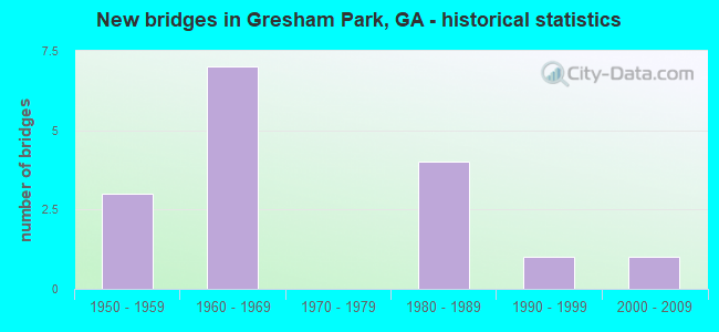
- New bridges - historical statistics
- 31950-1959
- 71960-1969
- 41980-1989
- 11990-1999
- 12000-2009

- Reconstructed bridges - Historical Statistics
- 31970-1979
- 01980-1989
- 11990-1999
- 02000-2009
- 22010-2019


- Bridge Condition - Deck
- 27.3%Very good
- 72.7%Good

- Bridge Condition - Superstructure
- 63.6%Very good
- 36.4%Good

- Bridge Condition - Substructure
- 81.8%Good
- 18.2%Satisfactory

- Bridge Condition - Channel
- 33.3%Very good
- 22.2%Good
- 22.2%Satisfactory
- 22.2%Fair

- Bridge Condition - Culverts
- 80.0%Good
- 20.0%Satisfactory
Find on map >> Show street view
Structure Number: 890054, Location: 4 MI SW OF DECATUR (Lat: 33.720919, Lng: -84.321239), Route carried "on" structure: Interstate 20, Year Built: 1959, Year Reconstructed: 1995, Status: Open, Structure Length: 1.52m (4.99ft), Average Daily Traffic: 132,720 (year 2011), Truck Traffic: 1%, Average Future Daily Traffic: 199,080 (year 2031), Design Load: HS 20+Mod, Features Intersected: SUGAR CREEK
Minimum Vertical Clearance: 30+ m (98+ ft), Kilometerpoint: 99.779, Lanes on structure: 10, Base Highway Network: Yes, Owner: State Highway Agency, Approaching Roadway Width: 51.2m (168.0ft), Skew: 33 degrees, Material/Design: Concrete, Design/Construction: Culvert, Number Of Spans In Main Unit: 4, Length of Maximum Span: 3.7m (12.1ft)
Condition: Channel: Good, Culverts: Good, Structural Evaluation: Better than present minimum criteria, Waterway Adequacy: Equal to present desirable criteria, Approach Roadway Alignment: Equal to present desirable criteria, Designated Inspection Frequency: Every 24 months, Inspection Date: April 2020, Bridge Improvement Cost: $622,000, Roadway Improvement Cost: $62,000, Total Project Cost: $932,000
Find on map >> Show street view
Structure Number: 890102, Location: 9.5 MI S OF DECATUR (Lat: 33.680311, Lng: -84.314942), Route carried "on" structure: Interstate 285, Year Built: 1966, Year Reconstructed: 1984, Status: Open, Structure Length: 5.94m (19.49ft), Average Daily Traffic: 148,250 (year 2011), Truck Traffic: 13%, Average Future Daily Traffic: 222,375 (year 2031), Design Load: HS 20+Mod, Features Intersected: SOUTH RIVER
Minimum Vertical Clearance: 30+ m (98+ ft), Kilometerpoint: 82.077, Lanes on structure: 10, Base Highway Network: Yes, Owner: State Highway Agency, Approaching Roadway Width: 46.3m (151.9ft), Skew: 33 degrees, Material/Design: Concrete, Design/Construction: Tee Beam, Number Of Spans In Main Unit: 5, Length of Maximum Span: 11.9m (39.0ft), Curb-To-Curb Width: 48.0m (157.5ft), Out-to-Out Width: 49.7m (163.1ft)
Condition: Deck: Good, Superstructure: Good, Substructure: Good, Channel: Fair, Operating Rating: 34.4 metric tons, Method Used To Determine Operating Rating: Load Factor (LF), Inventory Rating: 19.9 metric tons, Method Used To Determine Inventory Rating: Load Factor (LF), Structural Evaluation: Somewhat better than minimum adequacy, Deck Geometry: Superior to present desirable criteria, Waterway Adequacy: Equal to present desirable criteria, Approach Roadway Alignment: Equal to present desirable criteria, Designated Inspection Frequency: Every 24 months, Inspection Date: March 2020, Bridge Improvement Cost: $2,424,000, Roadway Improvement Cost: $242,000, Total Project Cost: $3,636,000, Deck Structure Type: Concrete Cast-file-Place, Wearing Surface/Protective System: Wearing Surface: Bituminous, Membrane: Built-up
Find on map >> Show street view
Structure Number: 890103, Location: 9.5 MI S OF DECATUR (Lat: 33.672631, Lng: -84.329089), Route carried "on" structure: Interstate 285, Year Built: 1967, Year Reconstructed: 1978, Status: Open, Structure Length: 6.86m (22.51ft), Average Daily Traffic: 105,190 (year 2011), Truck Traffic: 1%, Average Future Daily Traffic: 157,785 (year 2031), Design Load: HS 20+Mod, Features Intersected: NS RAILROAD
Minimum Vertical Clearance: 30+ m (98+ ft), Kilometerpoint: 83.686, Lanes on structure: 8, Base Highway Network: Yes, Owner: State Highway Agency, Approaching Roadway Width: 39.0m (128.0ft), Skew: 34 degrees, Material/Design: Steel continuous, Design/Construction: Stringer/Multi-beam, Number Of Spans In Main Unit: 3, Length of Maximum Span: 28.3m (92.8ft), Curb-To-Curb Width: 41.0m (134.5ft), Out-to-Out Width: 42.6m (139.8ft)
Condition: Deck: Good, Superstructure: Very good, Substructure: Good, Operating Rating: 46.2 metric tons, Method Used To Determine Operating Rating: Allowable Stress (AS), Inventory Rating: 32.6 metric tons, Method Used To Determine Inventory Rating: Allowable Stress (AS), Structural Evaluation: Better than present minimum criteria, Deck Geometry: Superior to present desirable criteria, Underclear: Somewhat better than minimum adequacy, Approach Roadway Alignment: Equal to present desirable criteria, Designated Inspection Frequency: Every 24 months, Inspection Date: April 2020, Bridge Improvement Cost: $2,318,000, Roadway Improvement Cost: $232,000, Total Project Cost: $3,477,000, Deck Structure Type: Concrete Cast-file-Place, Wearing Surface/Protective System: Wearing Surface: Bituminous, Membrane: Built-up
Find on map >> Show street view
Structure Number: 890104, Location: 9.5 MI S OF DECATUR (Lat: 33.672228, Lng: -84.330239), Route carried "on" structure: Interstate 285, Year Built: 1967, Year Reconstructed: 1983, Status: Open, Structure Length: 0.85m (2.79ft), Average Daily Traffic: 105,190 (year 2011), Truck Traffic: 1%, Average Future Daily Traffic: 157,785 (year 2031), Design Load: HS 20+Mod, Features Intersected: SOUTH RIVER TRIB
Minimum Vertical Clearance: 30+ m (98+ ft), Kilometerpoint: 83.686, Lanes on structure: 9, Base Highway Network: Yes, Owner: State Highway Agency, Approaching Roadway Width: 39.0m (128.0ft), Skew: 39 degrees, Material/Design: Concrete, Design/Construction: Culvert, Number Of Spans In Main Unit: 2, Length of Maximum Span: 4.3m (14.1ft)
Condition: Channel: Very good, Culverts: Good, Structural Evaluation: Better than present minimum criteria, Waterway Adequacy: Equal to present desirable criteria, Approach Roadway Alignment: Equal to present desirable criteria, Designated Inspection Frequency: Every 24 months, Inspection Date: March 2020, Bridge Improvement Cost: $318,000, Roadway Improvement Cost: $32,000, Total Project Cost: $477,000
Find on map >> Show street view
Structure Number: 890148, Location: 9 MI S OF DECATUR (Lat: 33.683931, Lng: -84.310003), Route carried "on" structure: City street 9092, Year Built: 1966, Status: Open, Structure Length: 7.53m (24.70ft), Average Daily Traffic: 21,150 (year 2011), Truck Traffic: 1%, Average Future Daily Traffic: 31,725 (year 2031), Design Load: HS 20+Mod, Features Intersected: I-285 (SR 407), Facility Carried by Structure: BOULDERCREST RD
Minimum Vertical Clearance: 30+ m (98+ ft), Kilometerpoint: 3.219, Lanes on structure: 4, Lanes under structure: 8, Base Highway Network: Yes, Owner: State Highway Agency, Approaching Roadway Width: 16.5m (54.1ft), Skew: 21 degrees, Material/Design: Steel continuous, Design/Construction: Stringer/Multi-beam, Number Of Spans In Main Unit: 4, Length of Maximum Span: 21.9m (71.9ft), Curb or Sidewalk Widths: Left: 1.5m (4.9ft), Right: 1.5m (4.9ft), Curb-To-Curb Width: 17.1m (56.1ft), Out-to-Out Width: 22.1m (72.5ft)
Condition: Deck: Good, Superstructure: Good, Substructure: Good, Operating Rating: 52.6 metric tons, Method Used To Determine Operating Rating: Load Factor (LF), Inventory Rating: 31.7 metric tons, Method Used To Determine Inventory Rating: Load Factor (LF), Structural Evaluation: Better than present minimum criteria, Deck Geometry: Somewhat better than minimum adequacy, Underclear: Somewhat better than minimum adequacy, Approach Roadway Alignment: Equal to present desirable criteria, Designated Inspection Frequency: Every 24 months, Inspection Date: April 2020, Bridge Improvement Cost: $1,491,000, Roadway Improvement Cost: $149,000, Total Project Cost: $2,237,000, Deck Structure Type: Concrete Cast-file-Place
Find on map >> Show street view
Structure Number: 890149, Location: 6 MI S OF DECATUR (Lat: 33.688969, Lng: -84.330039), Route carried "on" structure: City street 9082, Year Built: 1958, Year Reconstructed: 2017, Status: Open, Structure Length: 3.09m (10.14ft), Average Daily Traffic: 5,350 (year 2012), Truck Traffic: 1%, Average Future Daily Traffic: 8,025 (year 2032), Design Load: H 15, Features Intersected: ENTRENCHMENT CREEK, Facility Carried by Structure: CONSTITUTION ROAD
Minimum Vertical Clearance: 30+ m (98+ ft), Kilometerpoint: 1.609, Lanes on structure: 2, Base Highway Network: Yes, Owner: County Highway Agency, Approaching Roadway Width: 6.7m (22.0ft), Material/Design: Concrete, Design/Construction: Stringer/Multi-beam, Number Of Spans In Main Unit: 3, Length of Maximum Span: 11.3m (37.1ft), Curb or Sidewalk Widths: Left: 0.6m (2.0ft), Right: 0.6m (2.0ft), Curb-To-Curb Width: 8.5m (27.9ft), Out-to-Out Width: 9.4m (30.8ft)
Condition: Deck: Very good, Superstructure: Very good, Substructure: Good, Channel: Good, Operating Rating: 58.9 metric tons, Method Used To Determine Operating Rating: Load Factor (LF), Inventory Rating: 33.5 metric tons, Method Used To Determine Inventory Rating: Load Factor (LF), Structural Evaluation: Better than present minimum criteria, Deck Geometry: High priority of replacement, Waterway Adequacy: Superior to present desirable criteria, Approach Roadway Alignment: Equal to present desirable criteria, Length Of Structure Improvement: 9.45m (31.00ft), Designated Inspection Frequency: Every 24 months, Inspection Date: March 2020, Bridge Improvement Cost: $387,000, Roadway Improvement Cost: $39,000, Total Project Cost: $580,000, Deck Structure Type: Concrete Cast-file-Place
Find on map >> Show street view
Structure Number: 89015, Location: 5.3 MI S OF DECATUR (Lat: 33.694719, Lng: -84.303978), Route carried "on" structure: City street 9119, Year Built: 1965, Status: Open, Structure Length: 0.98m (3.22ft), Average Daily Traffic: 12,240 (year 2011), Truck Traffic: 1%, Average Future Daily Traffic: 18,360 (year 2031), Design Load: H 15, Features Intersected: SUGAR CREEK, Facility Carried by Structure: CLIFTON CHURCH RD
Minimum Vertical Clearance: 30+ m (98+ ft), Kilometerpoint: 1.609, Lanes on structure: 2, Base Highway Network: Yes, Owner: County Highway Agency, Approaching Roadway Width: 7.3m (24.0ft), Material/Design: Concrete, Design/Construction: Culvert, Number Of Spans In Main Unit: 3, Length of Maximum Span: 3.0m (9.8ft), Curb or Sidewalk Widths: Left: 0.9m (3.0ft), Right: 0.0m
Condition: Channel: Satisfactory, Culverts: Good, Operating Rating: 43.5 metric tons, Method Used To Determine Operating Rating: Field evaluation and documented engineering judgment, Inventory Rating: 24.4 metric tons, Method Used To Determine Inventory Rating: Field evaluation and documented engineering judgment, Structural Evaluation: Equal to present minimum criteria, Waterway Adequacy: Superior to present desirable criteria, Approach Roadway Alignment: Equal to present desirable criteria, Designated Inspection Frequency: Every 24 months, Inspection Date: March 2020, Bridge Improvement Cost: $125,000, Roadway Improvement Cost: $13,000, Total Project Cost: $188,000
Find on map >> Show street view
Structure Number: 890151, Location: 5.3 MI SE OF DECATUR (Lat: 33.701169, Lng: -84.332239), Route carried "on" structure: County highway 9120, Year Built: 1958, Year Reconstructed: 2018, Status: Posted for load, Structure Length: 3.60m (11.81ft), Average Daily Traffic: 1,320 (year 2011), Truck Traffic: 1%, Average Future Daily Traffic: 1,980 (year 2031), Design Load: H 15, Features Intersected: ENTRENCHMENT CREEK, Facility Carried by Structure: KEY ROAD
Minimum Vertical Clearance: 30+ m (98+ ft), Kilometerpoint: 1.609, Lanes on structure: 2, Base Highway Network: Yes, Owner: County Highway Agency, Approaching Roadway Width: 7.3m (24.0ft), Skew: 3 degrees, Material/Design: Concrete, Design/Construction: Stringer/Multi-beam, Number Of Spans In Main Unit: 3, Length of Maximum Span: 13.7m (44.9ft), Curb or Sidewalk Widths: Left: 0.5m (1.6ft), Right: 0.5m (1.6ft), Curb-To-Curb Width: 8.6m (28.2ft), Out-to-Out Width: 10.2m (33.5ft)
Condition: Deck: Very good, Superstructure: Very good, Substructure: Good, Channel: Fair, Operating Rating: 62.5 metric tons, Method Used To Determine Operating Rating: Load Factor (LF), Inventory Rating: 34.4 metric tons, Method Used To Determine Inventory Rating: Load Factor (LF), Structural Evaluation: Better than present minimum criteria, Deck Geometry: Somewhat better than minimum adequacy, Waterway Adequacy: Equal to present desirable criteria, Approach Roadway Alignment: Better than present minimum criteria, Length Of Structure Improvement: 43.83m (143.80ft), Designated Inspection Frequency: Every 24 months, Inspection Date: March 2020, Bridge Improvement Cost: $461,000, Roadway Improvement Cost: $46,000, Total Project Cost: $692,000, Deck Structure Type: Concrete Cast-file-Place
Find on map >> Show street view
Structure Number: 890187, Location: 4 MI SE OF DECATUR (Lat: 33.715689, Lng: -84.323558), Route carried "on" structure: City street 9234, Year Built: 1960, Status: Open, Structure Length: 1.10m (3.61ft), Average Daily Traffic: 3,150 (year 2011), Truck Traffic: 1%, Average Future Daily Traffic: 4,725 (year 2031), Design Load: H 15, Features Intersected: SUGAR CREEK, Facility Carried by Structure: BRANNEN ROAD
Minimum Vertical Clearance: 30+ m (98+ ft), Kilometerpoint: 0.000, Lanes on structure: 2, Base Highway Network: Yes, Owner: City or Municipal Highway Agency, Approaching Roadway Width: 7.9m (25.9ft), Material/Design: Steel, Design/Construction: Culvert, Number Of Spans In Main Unit: 3, Length of Maximum Span: 3.4m (11.2ft)
Condition: Channel: Very good, Culverts: Satisfactory, Operating Rating: 43.5 metric tons, Method Used To Determine Operating Rating: Field evaluation and documented engineering judgment, Inventory Rating: 24.4 metric tons, Method Used To Determine Inventory Rating: Field evaluation and documented engineering judgment, Structural Evaluation: Equal to present minimum criteria, Waterway Adequacy: Equal to present desirable criteria, Approach Roadway Alignment: Equal to present minimum criteria, Designated Inspection Frequency: Every 24 months, Inspection Date: April 2020, Bridge Improvement Cost: $141,000, Roadway Improvement Cost: $14,000, Total Project Cost: $211,000
Find on map >> Show street view
Structure Number: 890282, Location: 5.5 MI S OF DECATUR (Lat: 33.675128, Lng: -84.327622), Route carried "on" structure: Ramp Interstate 285, Year Built: 1984, Status: Open, Structure Length: 9.20m (30.18ft), Average Daily Traffic: 74,810 (year 2011), Truck Traffic: 13%, Average Future Daily Traffic: 112,215 (year 2031), Design Load: HS 20+Mod, Features Intersected: SR413(I675R N TO I285 W)
Minimum Vertical Clearance: 30+ m (98+ ft), Kilometerpoint: 83.686, Lanes on structure: 2, Lanes under structure: 2, Base Highway Network: Yes, Owner: State Highway Agency, Approaching Roadway Width: 11.6m (38.1ft), Skew: 1 degrees, Material/Design: Prestressed concrete continuous, Design/Construction: Box Beam or Girders - Single/Spread, Number Of Spans In Main Unit: 2, Length of Maximum Span: 49.7m (163.1ft), Curb-To-Curb Width: 12.8m (42.0ft), Out-to-Out Width: 13.2m (43.3ft)
Condition: Deck: Good, Superstructure: Good, Substructure: Good, Operating Rating: 55.3 metric tons, Method Used To Determine Operating Rating: Allowable Stress (AS), Inventory Rating: 32.6 metric tons, Method Used To Determine Inventory Rating: Allowable Stress (AS), Structural Evaluation: Better than present minimum criteria, Deck Geometry: Superior to present desirable criteria, Underclear: Superior to present desirable criteria, Approach Roadway Alignment: Equal to present desirable criteria, Designated Inspection Frequency: Every 24 months, Inspection Date: April 2020, Bridge Improvement Cost: $1,180,000, Roadway Improvement Cost: $118,000, Total Project Cost: $1,770,000, Deck Structure Type: Concrete Cast-file-Place, Wearing Surface/Protective System: Deck Protection: Epoxy Coated Reinforcing
Find on map >> Show street view
Structure Number: 89029, Location: 7 MI S OF DECATUR (Lat: 33.672697, Lng: -84.328325), Route carried "on" structure: Interstate 675, Year Built: 1984, Status: Open, Structure Length: 13.78m (45.21ft), Average Daily Traffic: 74,810 (year 2011), Truck Traffic: 13%, Average Future Daily Traffic: 112,215 (year 2031), Design Load: HS 20+Mod, Features Intersected: I-285 (SR 407)
Minimum Vertical Clearance: 30+ m (98+ ft), Kilometerpoint: 16.093, Lanes on structure: 2, Lanes under structure: 8, Base Highway Network: Yes, Owner: State Highway Agency, Approaching Roadway Width: 11.6m (38.1ft), Skew: 2 degrees, Material/Design: Steel continuous, Design/Construction: Stringer/Multi-beam, Number Of Spans In Main Unit: 3, Length of Maximum Span: 51.8m (169.9ft), Curb-To-Curb Width: 12.8m (42.0ft), Out-to-Out Width: 13.8m (45.3ft)
Condition: Deck: Good, Superstructure: Very good, Substructure: Satisfactory, Operating Rating: 47.1 metric tons, Method Used To Determine Operating Rating: Allowable Stress (AS), Inventory Rating: 32.6 metric tons, Method Used To Determine Inventory Rating: Allowable Stress (AS), Structural Evaluation: Equal to present minimum criteria, Deck Geometry: Equal to present desirable criteria, Underclear: Meets minimum limits, Approach Roadway Alignment: Equal to present desirable criteria, Designated Inspection Frequency: Every 24 months, Inspection Date: March 2020, Bridge Improvement Cost: $1,766,000, Roadway Improvement Cost: $177,000, Total Project Cost: $2,649,000, Deck Structure Type: Concrete Cast-file-Place, Wearing Surface/Protective System: Deck Protection: Epoxy Coated Reinforcing
Find on map >> Show street view
Structure Number: 890291, Location: 9.5 MI S OF DECATUR (Lat: 33.673769, Lng: -84.326058), Route carried "on" structure: Interstate 675, Year Built: 1984, Status: Open, Structure Length: 8.53m (27.99ft), Average Daily Traffic: 74,810 (year 2011), Truck Traffic: 13%, Average Future Daily Traffic: 112,215 (year 2031), Design Load: HS 20+Mod, Features Intersected: I-285 (SR 407)
Minimum Vertical Clearance: 30+ m (98+ ft), Kilometerpoint: 16.093, Lanes on structure: 2, Lanes under structure: 8, Base Highway Network: Yes, Owner: State Highway Agency, Approaching Roadway Width: 11.6m (38.1ft), Material/Design: Steel continuous, Design/Construction: Stringer/Multi-beam, Number Of Spans In Main Unit: 2, Length of Maximum Span: 47.2m (154.9ft), Curb-To-Curb Width: 12.8m (42.0ft), Out-to-Out Width: 13.8m (45.3ft)
Condition: Deck: Good, Superstructure: Good, Substructure: Satisfactory, Operating Rating: 52.6 metric tons, Method Used To Determine Operating Rating: Load Factor (LF), Inventory Rating: 30.8 metric tons, Method Used To Determine Inventory Rating: Load Factor (LF), Structural Evaluation: Equal to present minimum criteria, Deck Geometry: Equal to present desirable criteria, Underclear: Somewhat better than minimum adequacy, Approach Roadway Alignment: Equal to present desirable criteria, Designated Inspection Frequency: Every 24 months, Inspection Date: March 2020, Bridge Improvement Cost: $1,094,000, Roadway Improvement Cost: $109,000, Total Project Cost: $1,641,000, Deck Structure Type: Concrete Cast-file-Place, Wearing Surface/Protective System: Deck Protection: Epoxy Coated Reinforcing
Find on map >> Show street view
Structure Number: 890292, Location: 5 MI S OF DECATUR (Lat: 33.675108, Lng: -84.329358), Route carried "on" structure: Ramp Interstate 675, Year Built: 1984, Status: Open, Structure Length: 4.54m (14.90ft), Average Daily Traffic: 74,810 (year 2011), Truck Traffic: 13%, Average Future Daily Traffic: 112,215 (year 2031), Design Load: HS 20+Mod, Features Intersected: NS RAILROAD
Minimum Vertical Clearance: 30+ m (98+ ft), Kilometerpoint: 16.093, Lanes on structure: 2, Base Highway Network: Yes, Owner: State Highway Agency, Approaching Roadway Width: 11.6m (38.1ft), Skew: 1 degrees, Material/Design: Prestressed concrete, Design/Construction: Stringer/Multi-beam, Number Of Spans In Main Unit: 3, Length of Maximum Span: 17.4m (57.1ft), Curb-To-Curb Width: 12.8m (42.0ft), Out-to-Out Width: 13.8m (45.3ft)
Condition: Deck: Good, Superstructure: Very good, Substructure: Good, Operating Rating: 52.6 metric tons, Method Used To Determine Operating Rating: Load Factor (LF), Inventory Rating: 31.7 metric tons, Method Used To Determine Inventory Rating: Load Factor (LF), Structural Evaluation: Better than present minimum criteria, Deck Geometry: Superior to present desirable criteria, Underclear: Superior to present desirable criteria, Approach Roadway Alignment: Equal to present desirable criteria, Designated Inspection Frequency: Every 24 months, Inspection Date: April 2020, Bridge Improvement Cost: $582,000, Roadway Improvement Cost: $58,000, Total Project Cost: $873,000, Deck Structure Type: Concrete Cast-file-Place, Wearing Surface/Protective System: Deck Protection: Epoxy Coated Reinforcing
Find on map >> Show street view
Structure Number: 890318, Location: 6 MI S OF DECATUR (Lat: 33.716000, Lng: -84.310453), Route carried "on" structure: City street 101, Year Built: 1992, Status: Open, Structure Length: 6.40m (21.00ft), Average Daily Traffic: 8,550 (year 2011), Truck Traffic: 1%, Average Future Daily Traffic: 12,825 (year 2031), Design Load: HS 20+Mod, Features Intersected: I-20, Facility Carried by Structure: GRESHAM ROAD
Minimum Vertical Clearance: 30+ m (98+ ft), Kilometerpoint: 3.219, Lanes on structure: 4, Lanes under structure: 10, Base Highway Network: Yes, Owner: State Highway Agency, Approaching Roadway Width: 15.8m (51.8ft), Skew: 3 degrees, Material/Design: Prestressed concrete, Design/Construction: Stringer/Multi-beam, Number Of Spans In Main Unit: 2, Length of Maximum Span: 32.0m (105.0ft), Curb or Sidewalk Widths: Left: 1.8m (5.9ft), Right: 1.8m (5.9ft), Curb-To-Curb Width: 15.8m (51.8ft), Out-to-Out Width: 20.2m (66.3ft)
Condition: Deck: Good, Superstructure: Very good, Substructure: Good, Operating Rating: 53.5 metric tons, Method Used To Determine Operating Rating: Load Factor (LF), Inventory Rating: 31.7 metric tons, Method Used To Determine Inventory Rating: Load Factor (LF), Structural Evaluation: Better than present minimum criteria, Deck Geometry: Meets minimum limits, Underclear: Somewhat better than minimum adequacy, Approach Roadway Alignment: Equal to present desirable criteria, Designated Inspection Frequency: Every 24 months, Inspection Date: May 2020, Bridge Improvement Cost: $1,268,000, Roadway Improvement Cost: $127,000, Total Project Cost: $1,902,000, Deck Structure Type: Concrete Cast-file-Place
Find on map >> Show street view
Structure Number: 895001, Location: 4 MI S OF DECATUR (Lat: 33.702989, Lng: -84.322189), Route carried "on" structure: County highway 94, Year Built: 1969, Status: Open, Structure Length: 1.31m (4.30ft), Average Daily Traffic: 2,202 (year 2011), Truck Traffic: 1%, Average Future Daily Traffic: 3,303 (year 2031), Design Load: H 15, Features Intersected: SUGAR CREEK, Facility Carried by Structure: MARY LOU LANE
Minimum Vertical Clearance: 30+ m (98+ ft), Kilometerpoint: 0.000, Lanes on structure: 2, Base Highway Network: Yes, Owner: County Highway Agency, Approaching Roadway Width: 7.9m (25.9ft), Material/Design: Concrete, Design/Construction: Culvert, Number Of Spans In Main Unit: 4, Length of Maximum Span: 3.0m (9.8ft), Curb or Sidewalk Widths: Left: 0.0m, Right: 1.5m (4.9ft)
Condition: Channel: Satisfactory, Culverts: Good, Operating Rating: 43.5 metric tons, Method Used To Determine Operating Rating: Field evaluation and documented engineering judgment, Inventory Rating: 24.4 metric tons, Method Used To Determine Inventory Rating: Field evaluation and documented engineering judgment, Structural Evaluation: Equal to present minimum criteria, Waterway Adequacy: Equal to present desirable criteria, Approach Roadway Alignment: Equal to present desirable criteria, Designated Inspection Frequency: Every 24 months, Inspection Date: April 2020, Bridge Improvement Cost: $168,000, Roadway Improvement Cost: $17,000, Total Project Cost: $252,000
Find on map >> Show street view
Structure Number: 895157, Location: 6.5 MI S OF DECATUR (Lat: 33.679628, Lng: -84.307878), Route carried "on" structure: County highway 5187, Year Built: 2007, Status: Open, Structure Length: 7.07m (23.20ft), Average Daily Traffic: 17,680 (year 2011), Truck Traffic: 1%, Average Future Daily Traffic: 26,520 (year 2031), Design Load: HS 20+Mod, Features Intersected: SOUTH RIVER, Facility Carried by Structure: BOULDERCREST ROAD
Minimum Vertical Clearance: 30+ m (98+ ft), Kilometerpoint: 3.219, Lanes on structure: 4, Base Highway Network: Yes, Owner: County Highway Agency, Approaching Roadway Width: 6.1m (20.0ft), Material/Design: Prestressed concrete, Design/Construction: Stringer/Multi-beam, Number Of Spans In Main Unit: 3, Length of Maximum Span: 33.8m (110.9ft), Curb or Sidewalk Widths: Left: 1.8m (5.9ft), Right: 1.8m (5.9ft), Curb-To-Curb Width: 14.6m (47.9ft), Out-to-Out Width: 19.0m (62.3ft)
Condition: Deck: Very good, Superstructure: Very good, Substructure: Good, Channel: Very good, Operating Rating: 54.4 metric tons, Method Used To Determine Operating Rating: Allowable Stress (AS), Inventory Rating: 32.6 metric tons, Method Used To Determine Inventory Rating: Allowable Stress (AS), Structural Evaluation: Better than present minimum criteria, Deck Geometry: High priority of replacement, Waterway Adequacy: Equal to present desirable criteria, Approach Roadway Alignment: Equal to present desirable criteria, Designated Inspection Frequency: Every 24 months, Inspection Date: April 2020, Bridge Improvement Cost: $1,401,000, Roadway Improvement Cost: $140,000, Total Project Cost: $2,101,000, Deck Structure Type: Concrete Cast-file-Place
Find on map >> Show street view
Structure Number: 890148, Location: 9 MI S OF DECATUR (Lat: 33.683931, Lng: -84.310003), Route carried "under" structure: Interstate 285, Structure Length: 0. m, Average Daily Traffic: 129,500 (year 1999), Truck Traffic: 1%, Features Intersected: M-9092 BOULDERCREST RD., Facility Carried by Structure: BOULDERCREST RD
Minimum Vertical Clearance: 5.08m (16.67ft), Kilometerpoint: 82.077, Lanes on structure: 4, Length of Maximum Span: 0.0m
Find on map >> Show street view
Structure Number: 890282, Location: 5.5 MI S OF DECATUR (Lat: 33.675128, Lng: -84.327622), Route carried "under" structure: Ramp Interstate 675, Structure Length: 0. m, Average Daily Traffic: 60,500 (year 1999), Truck Traffic: 1%, Features Intersected: I-285 RAMP TO I-675 SB
Minimum Vertical Clearance: 6.17m (20.24ft), Kilometerpoint: 16.093, Lanes on structure: 2, Length of Maximum Span: 0.0m
Find on map >> Show street view
Structure Number: 89029, Location: 7 MI S OF DECATUR (Lat: 33.672697, Lng: -84.328325), Route carried "under" structure: Interstate 285, Structure Length: 0. m, Average Daily Traffic: 79,600 (year 1999), Truck Traffic: 1%, Features Intersected: I-675 SBL (SR 413), Facility Carried by Structure: I-675 SBL
Minimum Vertical Clearance: 7.59m (24.90ft), Kilometerpoint: 83.686, Lanes on structure: 2, Length of Maximum Span: 0.0m
Find on map >> Show street view
Structure Number: 890291, Location: 9.5 MI S OF DECATUR (Lat: 33.673769, Lng: -84.326058), Route carried "under" structure: Interstate 285, Structure Length: 0. m, Average Daily Traffic: 115,600 (year 1999), Truck Traffic: 1%, Features Intersected: I-675 NBL (SR 413), Facility Carried by Structure: I-675 NBL
Minimum Vertical Clearance: 6.80m (22.31ft), Kilometerpoint: 83.686, Lanes on structure: 2, Length of Maximum Span: 0.0m
Find on map >> Show street view
Structure Number: 890318, Location: 6 MI S OF DECATUR (Lat: 33.716000, Lng: -84.310453), Route carried "under" structure: Interstate 20, Structure Length: 0. m, Average Daily Traffic: 131,500 (year 1999), Truck Traffic: 1%, Features Intersected: CR 101 GRESHAM ROAD, Facility Carried by Structure: GRESHAM ROAD
Minimum Vertical Clearance: 6.85m (22.47ft), Kilometerpoint: 101.389, Lanes on structure: 4, Length of Maximum Span: 0.0m