Bridge Statistics for Greensburg, Pennsylvania (PA)
Condition, Traffic, Stress, Structural Evaluation, Project Costs
- National Bridge Inventory (NBI) Statistics
- 45Number of bridges
- 249ft / 75.8mTotal length
- $9,609,000Total costs
- 435,686Total average daily traffic
- 21,939Total average daily truck traffic
- National Bridge Inventory (NBI) Registered Bridges for Greensburg
- No street view available for this location
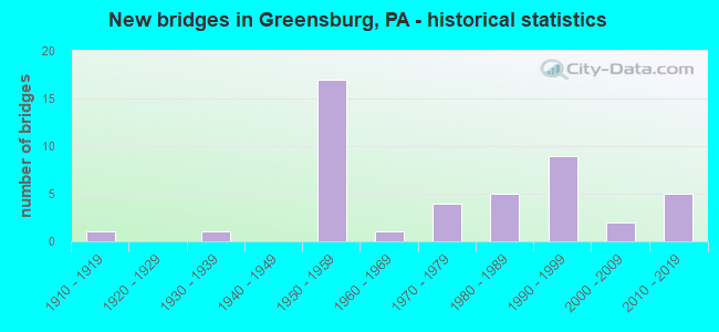
- New bridges - historical statistics
- 11910-1919
- 11930-1939
- 171950-1959
- 11960-1969
- 41970-1979
- 51980-1989
- 91990-1999
- 22000-2009
- 52010-2019
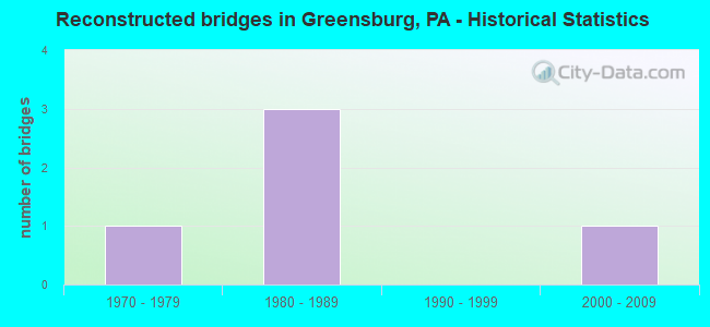
- Reconstructed bridges - Historical Statistics
- 11970-1979
- 31980-1989
- 01990-1999
- 12000-2009
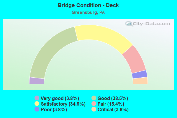
- Bridge Condition - Deck
- 3.8%Very good
- 38.5%Good
- 34.6%Satisfactory
- 15.4%Fair
- 3.8%Poor
- 3.8%Critical
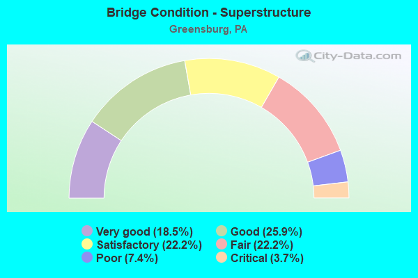
- Bridge Condition - Superstructure
- 18.5%Very good
- 25.9%Good
- 22.2%Satisfactory
- 22.2%Fair
- 7.4%Poor
- 3.7%Critical
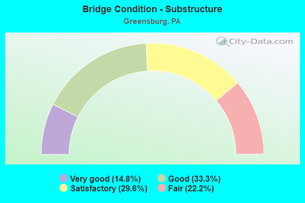
- Bridge Condition - Substructure
- 14.8%Very good
- 33.3%Good
- 29.6%Satisfactory
- 22.2%Fair

- Bridge Condition - Channel
- 16.7%Excellent
- 38.9%Very good
- 27.8%Good
- 16.7%Satisfactory
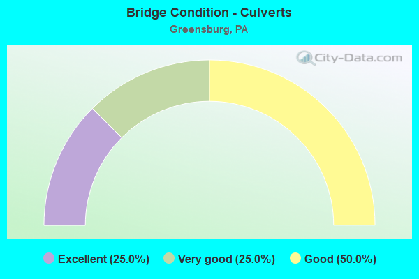
- Bridge Condition - Culverts
- 25.0%Excellent
- 25.0%Very good
- 50.0%Good
Find on map >> Show street view
Structure Number: 35931, Location: HEMPFIELD TOWNSHIP (Lat: 40.306697, Lng: -79.575000), Route carried "on" structure: US 30, Year Built: 1936, Status: Open, Structure Length: 2.13m (6.99ft), Average Daily Traffic: 17,770 (year 2021), Truck Traffic: 4%, Average Future Daily Traffic: 22,513 (year 2032), Design Load: HS 20+Mod, Features Intersected: Southwest PA Railroad
Minimum Vertical Clearance: 30+ m (98+ ft), Kilometerpoint: 18.730, Lanes on structure: 3, Base Highway Network: Yes, Owner: Railroad, Approaching Roadway Width: 13.4m (44.0ft), Skew: 10 degrees, Material/Design: Concrete, Design/Construction: Arch - Deck, Number Of Spans In Main Unit: 1, Length of Maximum Span: 21.3m (69.9ft), Curb or Sidewalk Widths: Left: 0.5m (1.6ft), Right: 0.5m (1.6ft), Curb-To-Curb Width: 13.4m (44.0ft), Out-to-Out Width: 17.2m (56.4ft)
Condition: Superstructure: Fair, Substructure: Fair, Operating Rating: 89.8 metric tons, Method Used To Determine Operating Rating: Load Factor (LF), Inventory Rating: 78.9 metric tons, Method Used To Determine Inventory Rating: Load Factor (LF), Structural Evaluation: Somewhat better than minimum adequacy, Deck Geometry: Somewhat better than minimum adequacy, Underclear: High priority of corrective action, Approach Roadway Alignment: Equal to present desirable criteria, Length Of Structure Improvement: 5.30m (17.39ft), Designated Inspection Frequency: Every 24 months, Inspection Date: April 2021
Find on map >> Show street view
Structure Number: 35932, Location: HEMPFIELD TOWNSHIP (Lat: 40.306397, Lng: -79.575697), Route carried "on" structure: US 30, Year Built: 1959, Year Reconstructed: 1989, Status: Open, Structure Length: 4.42m (14.50ft), Average Daily Traffic: 17,180 (year 2021), Truck Traffic: 4%, Average Future Daily Traffic: 22,177 (year 2032), Design Load: HS 20+Mod, Features Intersected: Southwest PA Railroad
Minimum Vertical Clearance: 30+ m (98+ ft), Kilometerpoint: 18.717, Lanes on structure: 3, Base Highway Network: Yes, Owner: Railroad, Maintenance Responsibility: State Highway Agency, Approaching Roadway Width: 11.0m (36.1ft), Material/Design: Steel continuous, Design/Construction: Stringer/Multi-beam, Number Of Spans In Main Unit: 3, Length of Maximum Span: 22.3m (73.2ft), Curb or Sidewalk Widths: Left: 0.2m (0.7ft), Right: 0.2m (0.7ft), Curb-To-Curb Width: 13.0m (42.7ft), Out-to-Out Width: 13.7m (44.9ft)
Condition: Deck: Satisfactory, Superstructure: Fair, Substructure: Satisfactory, Operating Rating: 86.2 metric tons, Method Used To Determine Operating Rating: Load Factor (LF), Inventory Rating: 51.7 metric tons, Method Used To Determine Inventory Rating: Load Factor (LF), Structural Evaluation: Somewhat better than minimum adequacy, Deck Geometry: Meets minimum limits, Underclear: High priority of corrective action, Approach Roadway Alignment: Equal to present desirable criteria, Length Of Structure Improvement: 5.30m (17.39ft), Designated Inspection Frequency: Every 24 months, Other Special Inspection Frequency: Every 12 months, Inspection Date: April 2021, Other Special Inspection Date: April 2021, Deck Structure Type: Concrete Cast-file-Place, Wearing Surface/Protective System: Wearing Surface: Monolithic Concrete, Deck Protection: Epoxy Coated Reinforcing
Find on map >> Show street view
Structure Number: 35933, Location: HEMPFIELD TOWNSHIP (Lat: 40.303603, Lng: -79.563058), Route carried "on" structure: US 30, Year Built: 1959, Year Reconstructed: 1988, Status: Open, Structure Length: 7.96m (26.12ft), Average Daily Traffic: 31,225 (year 2022), Truck Traffic: 3%, Average Future Daily Traffic: 22,606 (year 2032), Design Load: HS 20+Mod, Features Intersected: SR 3026
Minimum Vertical Clearance: 30+ m (98+ ft), Kilometerpoint: 20.423, Lanes on structure: 4, Lanes under structure: 3, Base Highway Network: Yes, Owner: State Highway Agency, Approaching Roadway Width: 20.7m (67.9ft), Skew: 36 degrees, Material/Design: Steel continuous, Design/Construction: Stringer/Multi-beam, Number Of Spans In Main Unit: 3, Length of Maximum Span: 30.5m (100.1ft), Curb or Sidewalk Widths: Left: 0.2m (0.7ft), Right: 0.2m (0.7ft), Curb-To-Curb Width: 18.3m (60.0ft), Out-to-Out Width: 19.1m (62.7ft)
Condition: Deck: Satisfactory, Superstructure: Satisfactory, Substructure: Satisfactory, Operating Rating: 77.1 metric tons, Method Used To Determine Operating Rating: Load Factor (LF), Inventory Rating: 46.3 metric tons, Method Used To Determine Inventory Rating: Load Factor (LF), Structural Evaluation: Equal to present minimum criteria, Deck Geometry: Meets minimum limits, Underclear: Equal to present minimum criteria, Approach Roadway Alignment: Equal to present desirable criteria, Length Of Structure Improvement: 8.60m (28.22ft), Designated Inspection Frequency: Every 24 months, Inspection Date: April 2021, Deck Structure Type: Concrete Cast-file-Place, Wearing Surface/Protective System: Wearing Surface: Monolithic Concrete, Deck Protection: Epoxy Coated Reinforcing
Find on map >> Show street view
Structure Number: 35937, Location: HEMPFIELD TOWNSHIP (Lat: 40.287828, Lng: -79.530239), Route carried "on" structure: US 30, Year Built: 1959, Year Reconstructed: 1982, Status: Open, Structure Length: 4.63m (15.19ft), Average Daily Traffic: 38,457 (year 2020), Truck Traffic: 8%, Average Future Daily Traffic: 57,414 (year 2032), Design Load: H 20, Features Intersected: Mt Pleasant Rd (County)
Minimum Vertical Clearance: 30+ m (98+ ft), Kilometerpoint: 24.629, Lanes on structure: 4, Lanes under structure: 2, Base Highway Network: Yes, Owner: State Highway Agency, Approaching Roadway Width: 19.8m (65.0ft), Skew: 31 degrees, Material/Design: Steel continuous, Design/Construction: Stringer/Multi-beam, Number Of Spans In Main Unit: 3, Length of Maximum Span: 23.5m (77.1ft), Curb or Sidewalk Widths: Left: 0.2m (0.7ft), Right: 0.2m (0.7ft), Curb-To-Curb Width: 20.7m (67.9ft), Out-to-Out Width: 21.8m (71.5ft)
Condition: Deck: Satisfactory, Superstructure: Satisfactory, Substructure: Satisfactory, Operating Rating: 59.9 metric tons, Method Used To Determine Operating Rating: Load Factor (LF), Inventory Rating: 35.4 metric tons, Method Used To Determine Inventory Rating: Load Factor (LF), Structural Evaluation: Equal to present minimum criteria, Deck Geometry: Equal to present minimum criteria, Underclear: Meets minimum limits, Approach Roadway Alignment: Equal to present desirable criteria, Length Of Structure Improvement: 5.40m (17.72ft), Designated Inspection Frequency: Every 24 months, Inspection Date: April 2021, Deck Structure Type: Concrete Cast-file-Place, Wearing Surface/Protective System: Wearing Surface: Monolithic Concrete, Deck Protection: Epoxy Coated Reinforcing
Find on map >> Show street view
Structure Number: 3602, Location: CITY OF GREENSBURG (Lat: 40.305053, Lng: -79.545147), Route carried "on" structure: Business State highway 66B, Year Built: 1989, Status: Open, Structure Length: 2.62m (8.60ft), Average Daily Traffic: 7,087 (year 2020), Truck Traffic: 5%, Average Future Daily Traffic: 14,039 (year 2032), Design Load: HS 25 or greater, Features Intersected: Norfolk Southern Railway, Facility Carried by Structure: SR 0066
Minimum Vertical Clearance: 30+ m (98+ ft), Kilometerpoint: 0.122, Lanes on structure: 2, Owner: State Highway Agency, Approaching Roadway Width: 10.7m (35.1ft), Material/Design: Prestressed concrete, Design/Construction: Box Beam or Girders - Multiple, Number Of Spans In Main Unit: 1, Length of Maximum Span: 25.3m (83.0ft), Curb or Sidewalk Widths: Left: 2.7m (8.9ft), Right: 2.7m (8.9ft), Curb-To-Curb Width: 11.6m (38.1ft), Out-to-Out Width: 18.5m (60.7ft)
Condition: Deck: Satisfactory, Superstructure: Satisfactory, Substructure: Satisfactory, Inventory Rating: 99.8 metric tons, Method Used To Determine Inventory Rating: Load Factor (LF), Structural Evaluation: Equal to present minimum criteria, Deck Geometry: Somewhat better than minimum adequacy, Underclear: High priority of replacement, Approach Roadway Alignment: Equal to present desirable criteria, Length Of Structure Improvement: 4.00m (13.12ft), Designated Inspection Frequency: Every 48 months, Inspection Date: May 2021, Bridge Improvement Cost: $70,000, Roadway Improvement Cost: $205,000, Total Project Cost: $940,000, Deck Structure Type: Concrete Cast-file-Place, Wearing Surface/Protective System: Wearing Surface: Monolithic Concrete, Deck Protection: Epoxy Coated Reinforcing
Find on map >> Show street view
Structure Number: 36101, Location: HEMPFIELD TOWNSHIP (Lat: 40.317103, Lng: -79.521689), Route carried "on" structure: US 119, Year Built: 1992, Status: Open, Structure Length: 1.37m (4.49ft), Average Daily Traffic: 9,982 (year 2022), Truck Traffic: 2%, Average Future Daily Traffic: 14,595 (year 2032), Design Load: HS 25 or greater, Features Intersected: JACKS RUN
Minimum Vertical Clearance: 30+ m (98+ ft), Kilometerpoint: 25.993, Lanes on structure: 2, Owner: State Highway Agency, Approaching Roadway Width: 12.2m (40.0ft), Skew: 2 degrees, Material/Design: Prestressed concrete, Design/Construction: Box Beam or Girders - Multiple, Number Of Spans In Main Unit: 1, Length of Maximum Span: 12.8m (42.0ft), Curb or Sidewalk Widths: Left: 0.2m (0.7ft), Right: 0.2m (0.7ft), Curb-To-Curb Width: 19.8m (65.0ft), Out-to-Out Width: 20.9m (68.6ft)
Condition: Deck: Satisfactory, Superstructure: Good, Substructure: Good, Channel: Satisfactory, Operating Rating: 84.4 metric tons, Method Used To Determine Operating Rating: Load Factor (LF), Inventory Rating: 34.5 metric tons, Method Used To Determine Inventory Rating: Load Factor (LF), Structural Evaluation: Better than present minimum criteria, Deck Geometry: Superior to present desirable criteria, Waterway Adequacy: Superior to present desirable criteria, Approach Roadway Alignment: Equal to present desirable criteria, Length Of Structure Improvement: 2.10m (6.89ft), Designated Inspection Frequency: Every 24 months, Inspection Date: May 2021, Deck Structure Type: Concrete Cast-file-Place, Wearing Surface/Protective System: Wearing Surface: Monolithic Concrete, Deck Protection: Epoxy Coated Reinforcing
Find on map >> Show street view
Structure Number: 36113, Location: HEMPFIELD TOWNSHIP (Lat: 40.297458, Lng: -79.522336), Route carried "on" structure: State highway 130, Year Built: 1959, Status: Open, Structure Length: 4.51m (14.80ft), Average Daily Traffic: 11,245 (year 2022), Truck Traffic: 2%, Average Future Daily Traffic: 10,454 (year 2032), Design Load: HS 20+Mod, Features Intersected: SR 0030
Minimum Vertical Clearance: 30+ m (98+ ft), Kilometerpoint: 24.510, Lanes on structure: 2, Lanes under structure: 8, Owner: State Highway Agency, Approaching Roadway Width: 11.6m (38.1ft), Skew: 2 degrees, Material/Design: Steel, Design/Construction: Stringer/Multi-beam, Number Of Spans In Main Unit: 3, Length of Maximum Span: 23.8m (78.1ft), Curb or Sidewalk Widths: Left: 1.5m (4.9ft), Right: 0.5m (1.6ft), Curb-To-Curb Width: 11.6m (38.1ft), Out-to-Out Width: 14.2m (46.6ft)
Condition: Deck: Fair, Superstructure: Satisfactory, Substructure: Fair, Operating Rating: 60.8 metric tons, Method Used To Determine Operating Rating: Load Factor (LF), Inventory Rating: 36.3 metric tons, Method Used To Determine Inventory Rating: Load Factor (LF), Structural Evaluation: Somewhat better than minimum adequacy, Deck Geometry: Somewhat better than minimum adequacy, Underclear: High priority of corrective action, Approach Roadway Alignment: Equal to present desirable criteria, Length Of Structure Improvement: 4.50m (14.76ft), Designated Inspection Frequency: Every 24 months, Inspection Date: May 2021, Bridge Improvement Cost: $38,000, Roadway Improvement Cost: $200,000, Total Project Cost: $515,000, Deck Structure Type: Concrete Cast-file-Place, Wearing Surface/Protective System: Wearing Surface: Bituminous
Find on map >> Show street view
Structure Number: 36115, Location: CITY OF GREENSBURG (Lat: 40.303386, Lng: -79.538511), Route carried "on" structure: State highway 130, Year Built: 1959, Status: Open, Structure Length: 0.82m (2.69ft), Average Daily Traffic: 17,166 (year 2022), Truck Traffic: 1%, Average Future Daily Traffic: 18,448 (year 2032), Design Load: HS 20, Features Intersected: JACKS RUN
Minimum Vertical Clearance: 30+ m (98+ ft), Kilometerpoint: 23.318, Lanes on structure: 2, Base Highway Network: Yes, Owner: State Highway Agency, Approaching Roadway Width: 9.1m (29.9ft), Material/Design: Concrete, Design/Construction: Tee Beam, Number Of Spans In Main Unit: 1, Length of Maximum Span: 7.9m (25.9ft), Curb or Sidewalk Widths: Left: 2.1m (6.9ft), Right: 2.1m (6.9ft), Curb-To-Curb Width: 9.1m (29.9ft), Out-to-Out Width: 14.2m (46.6ft)
Condition: Deck: Satisfactory, Superstructure: Fair, Substructure: Satisfactory, Channel: Very good, Operating Rating: 53.5 metric tons, Method Used To Determine Operating Rating: Load Factor (LF), Inventory Rating: 31.8 metric tons, Method Used To Determine Inventory Rating: Load Factor (LF), Structural Evaluation: Somewhat better than minimum adequacy, Deck Geometry: High priority of corrective action, Waterway Adequacy: Superior to present desirable criteria, Approach Roadway Alignment: Equal to present desirable criteria, Length Of Structure Improvement: 1.40m (4.59ft), Designated Inspection Frequency: Every 24 months, Inspection Date: May 2021, Bridge Improvement Cost: $5,000, Roadway Improvement Cost: $16,000, Total Project Cost: $72,000, Deck Structure Type: Concrete Cast-file-Place, Wearing Surface/Protective System: Wearing Surface: Bituminous
Find on map >> Show street view
Structure Number: 36134, Location: HEMPFIELD TOWNSHIP (Lat: 40.293292, Lng: -79.571833), Route carried "on" structure: State highway 136, Year Built: 1989, Status: Open, Structure Length: 1.34m (4.40ft), Average Daily Traffic: 7,803 (year 2020), Truck Traffic: 6%, Average Future Daily Traffic: 15,593 (year 2032), Design Load: HS 25 or greater, Features Intersected: Southwest PA Railroad
Minimum Vertical Clearance: 30+ m (98+ ft), Kilometerpoint: 28.448, Lanes on structure: 2, Owner: State Highway Agency, Approaching Roadway Width: 9.1m (29.9ft), Skew: 3 degrees, Material/Design: Prestressed concrete, Design/Construction: Box Beam or Girders - Multiple, Number Of Spans In Main Unit: 1, Length of Maximum Span: 12.8m (42.0ft), Curb or Sidewalk Widths: Left: 0.2m (0.7ft), Right: 0.2m (0.7ft), Curb-To-Curb Width: 10.3m (33.8ft), Out-to-Out Width: 11.0m (36.1ft)
Condition: Deck: Satisfactory, Superstructure: Good, Substructure: Good, Inventory Rating: 94.3 metric tons, Method Used To Determine Inventory Rating: Load Factor (LF), Structural Evaluation: Better than present minimum criteria, Deck Geometry: Meets minimum limits, Underclear: High priority of replacement, Approach Roadway Alignment: Better than present minimum criteria, Length Of Structure Improvement: 6.70m (21.98ft), Designated Inspection Frequency: Every 48 months, Inspection Date: May 2021, Bridge Improvement Cost: $164,000, Roadway Improvement Cost: $482,000, Total Project Cost: $2,209,000, Deck Structure Type: Concrete Cast-file-Place, Wearing Surface/Protective System: Wearing Surface: Monolithic Concrete, Deck Protection: Epoxy Coated Reinforcing
Find on map >> Show street view
Structure Number: 36136, Location: CITY OF GREENSBURG (Lat: 40.296608, Lng: -79.557983), Route carried "on" structure: State highway 136, Year Built: 1959, Status: Posted for load, Structure Length: 5.94m (19.49ft), Average Daily Traffic: 8,490 (year 2020), Truck Traffic: 6%, Average Future Daily Traffic: 13,846 (year 2032), Design Load: H 20, Features Intersected: SR 0030 & ZELLERS RUN
Minimum Vertical Clearance: 30+ m (98+ ft), Kilometerpoint: 29.816, Lanes on structure: 4, Lanes under structure: 8, Owner: State Highway Agency, Approaching Roadway Width: 17.1m (56.1ft), Skew: 22 degrees, Material/Design: Steel continuous, Design/Construction: Stringer/Multi-beam, Number Of Spans In Main Unit: 2, Number Of Approach Spans: 1, Length of Maximum Span: 25.0m (82.0ft), Curb or Sidewalk Widths: Left: 0.5m (1.6ft), Right: 1.5m (4.9ft), Curb-To-Curb Width: 17.4m (57.1ft), Out-to-Out Width: 19.8m (65.0ft)
Condition: Deck: Fair, Superstructure: Fair, Substructure: Fair, Channel: Good, Operating Rating: 42.6 metric tons, Method Used To Determine Operating Rating: Load Factor (LF), Inventory Rating: 25.4 metric tons, Method Used To Determine Inventory Rating: Load Factor (LF), Structural Evaluation: Somewhat better than minimum adequacy, Deck Geometry: Somewhat better than minimum adequacy, Underclear: High priority of corrective action, Waterway Adequacy: Superior to present desirable criteria, Approach Roadway Alignment: Equal to present desirable criteria, Length Of Structure Improvement: 5.90m (19.36ft), Designated Inspection Frequency: Every 24 months, Other Special Inspection Frequency: Every 12 months, Inspection Date: May 2021, Other Special Inspection Date: May 2021, Bridge Improvement Cost: $41,000, Roadway Improvement Cost: $200,000, Total Project Cost: $549,000, Deck Structure Type: Concrete Cast-file-Place, Wearing Surface/Protective System: Wearing Surface: Bituminous, Membrane: Preformed Fabric
Find on map >> Show street view
Structure Number: 36427, Location: HEMPFIELD TOWNSHIP (Lat: 40.311739, Lng: -79.525075), Route carried "on" structure: State highway , Year Built: 1993, Status: Open, Structure Length: 0.70m (2.30ft), Average Daily Traffic: 5,977 (year 2021), Truck Traffic: 3%, Average Future Daily Traffic: 11,402 (year 2032), Design Load: HS 25 or greater, Features Intersected: JACKS RUN, Facility Carried by Structure: SR 1030
Minimum Vertical Clearance: 30+ m (98+ ft), Kilometerpoint: 0.000, Lanes on structure: 2, Owner: State Highway Agency, Approaching Roadway Width: 11.0m (36.1ft), Material/Design: Concrete, Design/Construction: Slab, Number Of Spans In Main Unit: 1, Length of Maximum Span: 6.7m (22.0ft), Curb-To-Curb Width: 11.0m (36.1ft), Out-to-Out Width: 12.1m (39.7ft)
Condition: Deck: Good, Superstructure: Good, Substructure: Good, Channel: Good, Operating Rating: 85.3 metric tons, Method Used To Determine Operating Rating: Load Factor (LF), Inventory Rating: 51.7 metric tons, Method Used To Determine Inventory Rating: Load Factor (LF), Structural Evaluation: Better than present minimum criteria, Deck Geometry: Meets minimum limits, Waterway Adequacy: Superior to present desirable criteria, Approach Roadway Alignment: Equal to present desirable criteria, Length Of Structure Improvement: 1.40m (4.59ft), Designated Inspection Frequency: Every 48 months, Inspection Date: December 2019, Bridge Improvement Cost: $17,000, Roadway Improvement Cost: $49,000, Total Project Cost: $226,000, Wearing Surface/Protective System: Wearing Surface: Monolithic Concrete, Deck Protection: Epoxy Coated Reinforcing
Find on map >> Show street view
Structure Number: 36442, Location: HEMPFIELD TOWNSHIP (Lat: 40.317100, Lng: -79.488297), Route carried "on" structure: State highway , Year Built: 1991, Status: Open, Structure Length: 2.44m (8.01ft), Average Daily Traffic: 5,759 (year 2021), Truck Traffic: 3%, Average Future Daily Traffic: 6,567 (year 2032), Design Load: HS 25 or greater, Features Intersected: Norfolk Southern Railway, Facility Carried by Structure: SR 1053
Minimum Vertical Clearance: 30+ m (98+ ft), Kilometerpoint: 1.033, Lanes on structure: 2, Owner: Railroad, Approaching Roadway Width: 9.1m (29.9ft), Material/Design: Prestressed concrete, Design/Construction: Box Beam or Girders - Multiple, Number Of Spans In Main Unit: 1, Length of Maximum Span: 24.4m (80.1ft), Curb or Sidewalk Widths: Left: 0.2m (0.7ft), Right: 0.2m (0.7ft), Curb-To-Curb Width: 11.6m (38.1ft), Out-to-Out Width: 12.3m (40.4ft)
Condition: Deck: Satisfactory, Superstructure: Fair, Substructure: Good, Inventory Rating: 48.1 metric tons, Method Used To Determine Inventory Rating: Load Factor (LF), Structural Evaluation: Somewhat better than minimum adequacy, Deck Geometry: Somewhat better than minimum adequacy, Underclear: High priority of corrective action, Approach Roadway Alignment: Better than present minimum criteria, Length Of Structure Improvement: 3.20m (10.50ft), Designated Inspection Frequency: Every 24 months, Inspection Date: October 2021, Deck Structure Type: Concrete Cast-file-Place, Wearing Surface/Protective System: Wearing Surface: Monolithic Concrete, Deck Protection: Epoxy Coated Reinforcing
Find on map >> Show street view
Structure Number: 36599, Location: HEMPFIELD TOWNSHIP (Lat: 40.295000, Lng: -79.555000), Route carried "on" structure: Ramp State highway , Year Built: 1959, Status: Open, Structure Length: 3.90m (12.80ft), Average Daily Traffic: 5,249 (year 2020), Truck Traffic: 7%, Average Future Daily Traffic: 8,937 (year 2032), Design Load: HS 20, Features Intersected: SR 0030, Facility Carried by Structure: SR 3030
Minimum Vertical Clearance: 30+ m (98+ ft), Kilometerpoint: 0.182, Lanes on structure: 2, Lanes under structure: 4, Base Highway Network: Yes, Owner: State Highway Agency, Approaching Roadway Width: 11.6m (38.1ft), Skew: 4 degrees, Material/Design: Steel, Design/Construction: Girder and Floorbeam System, Number Of Spans In Main Unit: 1, Length of Maximum Span: 38.4m (126.0ft), Curb or Sidewalk Widths: Left: 0.6m (2.0ft), Right: 0.6m (2.0ft), Curb-To-Curb Width: 11.6m (38.1ft), Out-to-Out Width: 14.3m (46.9ft)
Condition: Deck: Fair, Superstructure: Poor, Substructure: Fair, Operating Rating: 39.0 metric tons, Method Used To Determine Operating Rating: Load Factor (LF), Inventory Rating: 23.6 metric tons, Method Used To Determine Inventory Rating: Load Factor (LF), Structural Evaluation: Meets minimum limits, Deck Geometry: Superior to present desirable criteria, Underclear: High priority of corrective action, Approach Roadway Alignment: Equal to present desirable criteria, Length Of Structure Improvement: 4.70m (15.42ft), Designated Inspection Frequency: Every 24 months, Critical Feature Inspection Frequency: Every 12 months, Other Special Inspection Frequency: Every 12 months, Inspection Date: November 2019, Critical Feature Inspection Date: November 2020, Other Special Inspection Date: November 2020, Bridge Improvement Cost: $51,000, Roadway Improvement Cost: $150,000, Total Project Cost: $686,000, Deck Structure Type: Concrete Cast-file-Place, Wearing Surface/Protective System: Wearing Surface: Bituminous, Membrane: Other
Find on map >> Show street view
Structure Number: 36672, Location: HEMPFIELD TOWNSHIP (Lat: 40.285000, Lng: -79.573333), Route carried "on" structure: State highway , Year Built: 1995, Status: Open, Structure Length: 1.77m (5.81ft), Average Daily Traffic: 2,422 (year 2022), Truck Traffic: 1%, Average Future Daily Traffic: 3,429 (year 2032), Design Load: HS 25 or greater, Features Intersected: Southwest PA Railroad, Facility Carried by Structure: SR 3103
Minimum Vertical Clearance: 30+ m (98+ ft), Kilometerpoint: 3.405, Lanes on structure: 2, Owner: State Highway Agency, Approaching Roadway Width: 12.2m (40.0ft), Skew: 3 degrees, Material/Design: Prestressed concrete, Design/Construction: Box Beam or Girders - Single/Spread, Number Of Spans In Main Unit: 1, Length of Maximum Span: 17.1m (56.1ft), Curb or Sidewalk Widths: Left: 0.2m (0.7ft), Right: 0.2m (0.7ft), Curb-To-Curb Width: 10.4m (34.1ft), Out-to-Out Width: 11.4m (37.4ft)
Condition: Deck: Good, Superstructure: Good, Substructure: Satisfactory, Operating Rating: 89.8 metric tons, Method Used To Determine Operating Rating: Load Factor (LF), Inventory Rating: 59.0 metric tons, Method Used To Determine Inventory Rating: Load Factor (LF), Structural Evaluation: Equal to present minimum criteria, Deck Geometry: Somewhat better than minimum adequacy, Underclear: High priority of replacement, Approach Roadway Alignment: Better than present minimum criteria, Length Of Structure Improvement: 2.50m (8.20ft), Designated Inspection Frequency: Every 24 months, Inspection Date: Febuary 2020, Bridge Improvement Cost: $47,000, Roadway Improvement Cost: $139,000, Total Project Cost: $637,000, Deck Structure Type: Concrete Cast-file-Place, Wearing Surface/Protective System: Wearing Surface: Monolithic Concrete, Deck Protection: Epoxy Coated Reinforcing
Find on map >> Show street view
Structure Number: 36779, Location: HEMPFIELD TOWNSHIP (Lat: 40.346667, Lng: -79.571667), Route carried "on" structure: State highway 66B, Year Built: 1993, Status: Open, Structure Length: 0.64m (2.10ft), Average Daily Traffic: 9,638 (year 2022), Truck Traffic: 2%, Average Future Daily Traffic: 13,212 (year 2032), Design Load: HS 25 or greater, Features Intersected: TRIBUTARY BRUSH CREEK, Facility Carried by Structure: SR 0066
Minimum Vertical Clearance: 30+ m (98+ ft), Kilometerpoint: 5.544, Lanes on structure: 5, Owner: State Highway Agency, Approaching Roadway Width: 25.6m (84.0ft), Skew: 25 degrees, Material/Design: Concrete, Design/Construction: Culvert, Number Of Spans In Main Unit: 2, Length of Maximum Span: 2.7m (8.9ft)
Condition: Channel: Satisfactory, Culverts: Good, Inventory Rating: 85.3 metric tons, Method Used To Determine Inventory Rating: Load Factor (LF), Structural Evaluation: Better than present minimum criteria, Waterway Adequacy: Superior to present desirable criteria, Approach Roadway Alignment: Equal to present desirable criteria, Length Of Structure Improvement: 1.20m (3.94ft), Designated Inspection Frequency: Every 48 months, Inspection Date: April 2019
Find on map >> Show street view
Structure Number: 36808, Location: HEMPFIELD TOWNSHIP (Lat: 40.345000, Lng: -79.571667), Route carried "on" structure: Other road 66, Year Built: 1993, Status: Open, Structure Length: 9.27m (30.41ft), Average Daily Traffic: 10,429 (year 1998), Truck Traffic: 15%, Average Future Daily Traffic: 15,277 (year 2030), Design Load: HS 25 or greater, Features Intersected: SR 6066
Minimum Vertical Clearance: 30+ m (98+ ft), Kilometerpoint: 0.000, Lanes on structure: 2, Lanes under structure: 8, Base Highway Network: Yes, Toll: On toll road, Owner: State Toll Authority, Approaching Roadway Width: 12.8m (42.0ft), Skew: 11 degrees, Material/Design: Steel continuous, Design/Construction: Stringer/Multi-beam, Number Of Spans In Main Unit: 2, Length of Maximum Span: 45.4m (149.0ft), Curb or Sidewalk Widths: Left: 0.2m (0.7ft), Right: 0.2m (0.7ft), Curb-To-Curb Width: 12.8m (42.0ft), Out-to-Out Width: 13.9m (45.6ft)
Condition: Deck: Good, Superstructure: Good, Substructure: Good, Channel: Excellent, Operating Rating: 83.5 metric tons, Method Used To Determine Operating Rating: Load Factor (LF), Inventory Rating: 49.9 metric tons, Method Used To Determine Inventory Rating: Load Factor (LF), Structural Evaluation: Better than present minimum criteria, Deck Geometry: Equal to present desirable criteria, Underclear: Superior to present desirable criteria, Waterway Adequacy: Superior to present desirable criteria, Approach Roadway Alignment: Equal to present desirable criteria, Designated Inspection Frequency: Every 48 months, Inspection Date: November 2019, Deck Structure Type: Concrete Cast-file-Place, Wearing Surface/Protective System: Wearing Surface: Latex Concrete, Deck Protection: Epoxy Coated Reinforcing
Find on map >> Show street view
Structure Number: 36925, Location: 190' SOUTH OF SR 2013 (Lat: 40.282772, Lng: -79.516089), Route carried "on" structure: City street T987, Year Built: 1976, Year Reconstructed: 2007, Status: Open, Structure Length: 1.19m (3.90ft), Average Daily Traffic: 630 (year 2016), Average Future Daily Traffic: 840 (year 2036), Design Load: HL 93, Features Intersected: SLATE CREEK, Facility Carried by Structure: T-987 BROOKDALE DR
Minimum Vertical Clearance: 30+ m (98+ ft), Kilometerpoint: 0.000, Lanes on structure: 2, Owner: Town or Township Highway Agency, Approaching Roadway Width: 6.4m (21.0ft), Material/Design: Prestressed concrete, Design/Construction: Box Beam or Girders - Single/Spread, Number Of Spans In Main Unit: 1, Length of Maximum Span: 11.3m (37.1ft), Curb-To-Curb Width: 6.2m (20.3ft), Out-to-Out Width: 7.2m (23.6ft)
Condition: Deck: Good, Superstructure: Very good, Substructure: Very good, Channel: Very good, Operating Rating: 73.5 metric tons, Method Used To Determine Operating Rating: Load and Resistance Factor (LRFR), Inventory Rating: 49.9 metric tons, Method Used To Determine Inventory Rating: Load and Resistance Factor (LRFR), Structural Evaluation: Equal to present desirable criteria, Deck Geometry: High priority of corrective action, Waterway Adequacy: Superior to present desirable criteria, Approach Roadway Alignment: Equal to present desirable criteria, Length Of Structure Improvement: 1.50m (4.92ft), Designated Inspection Frequency: Every 24 months, Inspection Date: March 2020, Bridge Improvement Cost: $10,000, Roadway Improvement Cost: $28,000, Total Project Cost: $130,000, Deck Structure Type: Concrete Cast-file-Place, Wearing Surface/Protective System: Wearing Surface: Monolithic Concrete, Deck Protection: Epoxy Coated Reinforcing
Find on map >> Show street view
Structure Number: 36926, Location: WESTMORELAND MALL ENTRANC (Lat: 40.303175, Lng: -79.507269), Route carried "on" structure: Ramp City street , Year Built: 1977, Status: Open, Structure Length: 3.38m (11.09ft), Average Daily Traffic: 6,600 (year 2014), Truck Traffic: 10%, Average Future Daily Traffic: 7,392 (year 2034), Design Load: HS 20, Features Intersected: US 30 AND RAMP A (T605), Facility Carried by Structure: T605 Ramp 'A' Road
Minimum Vertical Clearance: 30+ m (98+ ft), Kilometerpoint: 0.000, Lanes on structure: 3, Lanes under structure: 7, Owner: Town or Township Highway Agency, Approaching Roadway Width: 12.2m (40.0ft), Material/Design: Prestressed concrete, Design/Construction: Stringer/Multi-beam, Number Of Spans In Main Unit: 1, Length of Maximum Span: 32.3m (106.0ft), Curb-To-Curb Width: 13.4m (44.0ft), Out-to-Out Width: 14.5m (47.6ft)
Condition: Deck: Good, Superstructure: Satisfactory, Substructure: Satisfactory, Inventory Rating: 40.8 metric tons, Method Used To Determine Inventory Rating: Load Factor (LF), Structural Evaluation: Equal to present minimum criteria, Deck Geometry: Somewhat better than minimum adequacy, Underclear: High priority of corrective action, Approach Roadway Alignment: Better than present minimum criteria, Length Of Structure Improvement: 4.20m (13.78ft), Designated Inspection Frequency: Every 24 months, Inspection Date: April 2020, Bridge Improvement Cost: $25,000, Roadway Improvement Cost: $72,000, Total Project Cost: $332,000, Deck Structure Type: Concrete Cast-file-Place, Wearing Surface/Protective System: Wearing Surface: Monolithic Concrete, Deck Protection: Epoxy Coated Reinforcing
Find on map >> Show street view
Structure Number: 36981, Location: 200' W of S URANIA Ave (Lat: 40.300325, Lng: -79.540561), Route carried "on" structure: City street BRWY, Year Built: 1960, Year Reconstructed: 1989, Status: Closed, Structure Length: 1.92m (6.30ft), Average Daily Traffic: 70 (year 2015), Truck Traffic: 10%, Average Future Daily Traffic: 90 (year 2035), Design Load: HS 20, Features Intersected: Jacks Run, Facility Carried by Structure: Brewery Street
Minimum Vertical Clearance: 30+ m (98+ ft), Kilometerpoint: 0.000, Lanes on structure: 2, Owner: City or Municipal Highway Agency, Approaching Roadway Width: 6.7m (22.0ft), Material/Design: Prestressed concrete, Design/Construction: Box Beam or Girders - Multiple, Number Of Spans In Main Unit: 1, Length of Maximum Span: 18.9m (62.0ft), Curb or Sidewalk Widths: Left: 0.6m (2.0ft), Right: 1.2m (3.9ft), Curb-To-Curb Width: 5.8m (19.0ft), Out-to-Out Width: 7.6m (24.9ft)
Condition: Deck: Critical, Superstructure: Critical, Substructure: Fair, Channel: Good, Operating Rating: 11.8 metric tons, Method Used To Determine Operating Rating: Load Factor (LF), Inventory Rating: 0.9 metric tons, Method Used To Determine Inventory Rating: Load Factor (LF), Deck Geometry: Meets minimum limits, Waterway Adequacy: Superior to present desirable criteria, Approach Roadway Alignment: Equal to present desirable criteria, Bridge Posting: Required (Relationship of Operating Rating to Maximum Legal Load: > 39.9% below), Length Of Structure Improvement: 2.80m (9.19ft), Designated Inspection Frequency: Every 24 months, Inspection Date: September 2021, Bridge Improvement Cost: $59,000, Roadway Improvement Cost: $172,000, Total Project Cost: $791,000, Deck Structure Type: Other, Wearing Surface/Protective System: Wearing Surface: Bituminous
Find on map >> Show street view
Structure Number: 36982, Location: BTW S URANIA & S MAIN (Lat: 40.296083, Lng: -79.542519), Route carried "on" structure: City street CLD, Year Built: 1989, Status: Open, Structure Length: 0.85m (2.79ft), Average Daily Traffic: 1,000 (year 2015), Truck Traffic: 3%, Average Future Daily Traffic: 2,860 (year 2035), Design Load: HS 25 or greater, Features Intersected: JACKS RUN, Facility Carried by Structure: EUCLID AVENUE
Minimum Vertical Clearance: 30+ m (98+ ft), Kilometerpoint: 0.000, Lanes on structure: 2, Owner: City or Municipal Highway Agency, Approaching Roadway Width: 6.7m (22.0ft), Material/Design: Prestressed concrete, Design/Construction: Box Beam or Girders - Single/Spread, Number Of Spans In Main Unit: 1, Length of Maximum Span: 8.2m (26.9ft), Curb or Sidewalk Widths: Left: 1.3m (4.3ft), Right: 1.0m (3.3ft), Curb-To-Curb Width: 6.7m (22.0ft), Out-to-Out Width: 9.6m (31.5ft)
Condition: Deck: Good, Superstructure: Good, Substructure: Good, Channel: Very good, Operating Rating: 42.6 metric tons, Method Used To Determine Operating Rating: Load Factor (LF), Inventory Rating: 25.4 metric tons, Method Used To Determine Inventory Rating: Load Factor (LF), Structural Evaluation: Equal to present minimum criteria, Deck Geometry: Meets minimum limits, Waterway Adequacy: Better than present minimum criteria, Approach Roadway Alignment: Equal to present desirable criteria, Length Of Structure Improvement: 0.90m (2.95ft), Designated Inspection Frequency: Every 24 months, Inspection Date: September 2021, Bridge Improvement Cost: $10,000, Roadway Improvement Cost: $29,000, Total Project Cost: $134,000, Deck Structure Type: Corrugated Steel, Wearing Surface/Protective System: Wearing Surface: Bituminous, Deck Protection: Epoxy Coated Reinforcing
Find on map >> Show street view
Structure Number: 36984, Location: BTW S URANIA & S MAIN (Lat: 40.295750, Lng: -79.543081), Route carried "on" structure: City street MT0L, Year Built: 1983, Status: Open, Structure Length: 1.19m (3.90ft), Average Daily Traffic: 4,000 (year 2016), Truck Traffic: 10%, Average Future Daily Traffic: 5,600 (year 2036), Design Load: HS 20+Mod, Features Intersected: JACKS RUN, Facility Carried by Structure: MT PLEASANT STREET
Minimum Vertical Clearance: 30+ m (98+ ft), Kilometerpoint: 0.000, Lanes on structure: 2, Owner: City or Municipal Highway Agency, Approaching Roadway Width: 8.5m (27.9ft), Skew: 3 degrees, Material/Design: Prestressed concrete, Design/Construction: Box Beam or Girders - Multiple, Number Of Spans In Main Unit: 1, Length of Maximum Span: 11.3m (37.1ft), Curb or Sidewalk Widths: Left: 0.0m, Right: 1.5m (4.9ft), Curb-To-Curb Width: 8.5m (27.9ft), Out-to-Out Width: 10.9m (35.8ft)
Condition: Deck: Fair, Superstructure: Fair, Substructure: Good, Channel: Excellent, Operating Rating: 54.4 metric tons, Method Used To Determine Operating Rating: Load Factor (LF), Inventory Rating: 24.5 metric tons, Method Used To Determine Inventory Rating: Load Factor (LF), Structural Evaluation: Somewhat better than minimum adequacy, Deck Geometry: Meets minimum limits, Waterway Adequacy: Better than present minimum criteria, Approach Roadway Alignment: Equal to present desirable criteria, Length Of Structure Improvement: 1.80m (5.91ft), Designated Inspection Frequency: Every 24 months, Inspection Date: September 2021, Deck Structure Type: Other, Wearing Surface/Protective System: Wearing Surface: Bituminous
Find on map >> Show street view
Structure Number: 36985, Location: NO. PA. AVE GREENSBURG (Lat: 40.304931, Lng: -79.546169), Route carried "on" structure: City street V, Year Built: 1985, Status: Open, Structure Length: 2.13m (6.99ft), Average Daily Traffic: 3,300 (year 2013), Average Future Daily Traffic: 3,795 (year 2033), Design Load: HS 25 or greater, Features Intersected: NORFOLK SOUTHERN M.L.
Minimum Vertical Clearance: 30+ m (98+ ft), Kilometerpoint: 0.000, Lanes on structure: 2, Owner: Town or Township Highway Agency, Maintenance Responsibility: City or Municipal Highway Agency, Approaching Roadway Width: 8.5m (27.9ft), Material/Design: Prestressed concrete, Design/Construction: Box Beam or Girders - Multiple, Number Of Spans In Main Unit: 1, Length of Maximum Span: 20.7m (67.9ft), Curb or Sidewalk Widths: Left: 1.8m (5.9ft), Right: 1.8m (5.9ft), Curb-To-Curb Width: 8.5m (27.9ft), Out-to-Out Width: 12.8m (42.0ft)
Condition: Deck: Satisfactory, Superstructure: Satisfactory, Substructure: Satisfactory, Inventory Rating: 37.2 metric tons, Method Used To Determine Inventory Rating: Load Factor (LF), Structural Evaluation: Equal to present minimum criteria, Deck Geometry: Meets minimum limits, Underclear: High priority of replacement, Approach Roadway Alignment: Equal to present desirable criteria, Length Of Structure Improvement: 4.90m (16.08ft), Designated Inspection Frequency: Every 24 months, Inspection Date: September 2019, Bridge Improvement Cost: $163,000, Roadway Improvement Cost: $481,000, Total Project Cost: $2,204,000, Deck Structure Type: Concrete Cast-file-Place, Wearing Surface/Protective System: Wearing Surface: Monolithic Concrete
Find on map >> Show street view
Structure Number: 36987, Location: 150' WEST OF S URANIA AVE (Lat: 40.302967, Lng: -79.538647), Route carried "on" structure: City street 2, Year Built: 1915, Status: Posted for load, Structure Length: 0.85m (2.79ft), Average Daily Traffic: 100 (year 2019), Average Future Daily Traffic: 120 (year 2035), Design Load: H 15, Features Intersected: JACKS RUN
Minimum Vertical Clearance: 30+ m (98+ ft), Kilometerpoint: 0.000, Lanes on structure: 1, Owner: City or Municipal Highway Agency, Approaching Roadway Width: 4.0m (13.1ft), Material/Design: Steel, Design/Construction: Stringer/Multi-beam, Number Of Spans In Main Unit: 1, Length of Maximum Span: 7.9m (25.9ft), Curb-To-Curb Width: 4.1m (13.5ft), Out-to-Out Width: 4.7m (15.4ft)
Condition: Deck: Poor, Superstructure: Poor, Substructure: Fair, Channel: Excellent, Operating Rating: 86.2 metric tons, Method Used To Determine Operating Rating: Load Factor (LF), Inventory Rating: 51.7 metric tons, Method Used To Determine Inventory Rating: Load Factor (LF), Structural Evaluation: Meets minimum limits, Deck Geometry: Somewhat better than minimum adequacy, Waterway Adequacy: Better than present minimum criteria, Approach Roadway Alignment: Equal to present desirable criteria, Length Of Structure Improvement: 1.10m (3.61ft), Designated Inspection Frequency: Every 24 months, Other Special Inspection Frequency: Every 12 months, Inspection Date: September 2021, Other Special Inspection Date: September 2021, Bridge Improvement Cost: $14,000, Roadway Improvement Cost: $40,000, Total Project Cost: $184,000, Deck Structure Type: Concrete Cast-file-Place, Wearing Surface/Protective System: Wearing Surface: Monolithic Concrete
Find on map >> Show street view
Structure Number: 39701, Location: SALEM TOWNSHIP (Lat: 40.351128, Lng: -79.504475), Route carried "on" structure: State highway , Year Built: 1997, Status: Open, Structure Length: 0.94m (3.08ft), Average Daily Traffic: 770 (year 2021), Truck Traffic: 3%, Average Future Daily Traffic: 2,253 (year 2032), Design Load: HS 25 or greater, Features Intersected: CRABTREE CREEK, Facility Carried by Structure: SR 1055
Minimum Vertical Clearance: 30+ m (98+ ft), Kilometerpoint: 1.405, Lanes on structure: 2, Owner: State Highway Agency, Approaching Roadway Width: 6.7m (22.0ft), Skew: 2 degrees, Material/Design: Prestressed concrete, Design/Construction: Box Beam or Girders - Multiple, Number Of Spans In Main Unit: 1, Length of Maximum Span: 8.8m (28.9ft), Curb or Sidewalk Widths: Left: 0.2m (0.7ft), Right: 0.2m (0.7ft), Curb-To-Curb Width: 10.4m (34.1ft), Out-to-Out Width: 11.4m (37.4ft)
Condition: Deck: Good, Superstructure: Good, Substructure: Good, Channel: Good, Operating Rating: 87.1 metric tons, Method Used To Determine Operating Rating: Load Factor (LF), Inventory Rating: 48.1 metric tons, Method Used To Determine Inventory Rating: Load Factor (LF), Structural Evaluation: Better than present minimum criteria, Deck Geometry: Equal to present minimum criteria, Waterway Adequacy: Equal to present minimum criteria, Approach Roadway Alignment: Equal to present desirable criteria, Length Of Structure Improvement: 1.60m (5.25ft), Designated Inspection Frequency: Every 48 months, Inspection Date: December 2019, Deck Structure Type: Concrete Cast-file-Place, Wearing Surface/Protective System: Wearing Surface: Integral Concrete, Deck Protection: Epoxy Coated Reinforcing
Find on map >> Show street view
Structure Number: 42976, Location: 200 BLOCK MAPLE AVENUE (Lat: 40.305336, Lng: -79.544144), Route carried "on" structure: City street M00L, Year Built: 2004, Status: Open, Structure Length: 2.29m (7.51ft), Average Daily Traffic: 6,600 (year 2015), Truck Traffic: 5%, Average Future Daily Traffic: 8,203 (year 2035), Design Load: HL 93, Features Intersected: NORFOLK SOUTHERN M.L., Facility Carried by Structure: MAPLE AVENUE
Minimum Vertical Clearance: 30+ m (98+ ft), Kilometerpoint: 0.000, Lanes on structure: 2, Owner: City or Municipal Highway Agency, Maintenance Responsibility: Railroad, Approaching Roadway Width: 10.4m (34.1ft), Material/Design: Prestressed concrete, Design/Construction: Box Beam or Girders - Single/Spread, Number Of Spans In Main Unit: 1, Length of Maximum Span: 22.6m (74.1ft), Curb or Sidewalk Widths: Left: 2.6m (8.5ft), Right: 2.6m (8.5ft), Curb-To-Curb Width: 10.4m (34.1ft), Out-to-Out Width: 16.2m (53.1ft)
Condition: Deck: Good, Superstructure: Very good, Substructure: Good, Inventory Rating: 85.3 metric tons, Method Used To Determine Inventory Rating: Load and Resistance Factor (LRFR), Structural Evaluation: Better than present minimum criteria, Deck Geometry: Meets minimum limits, Underclear: High priority of corrective action, Approach Roadway Alignment: Equal to present desirable criteria, Designated Inspection Frequency: Every 24 months, Inspection Date: September 2019, Deck Structure Type: Concrete Cast-file-Place, Wearing Surface/Protective System: Wearing Surface: Monolithic Concrete, Deck Protection: Epoxy Coated Reinforcing
Find on map >> Show street view
Structure Number: 45765, Location: SE of Greensburg (Lat: 40.284617, Lng: -79.513903), Route carried "on" structure: State highway 130, Year Built: 2009, Status: Open, Structure Length: 0.73m (2.40ft), Average Daily Traffic: 4,126 (year 2020), Truck Traffic: 5%, Average Future Daily Traffic: 3,908 (year 2032), Design Load: HL 93, Features Intersected: Slate Creek
Minimum Vertical Clearance: 30+ m (98+ ft), Kilometerpoint: 26.794, Lanes on structure: 2, Owner: State Highway Agency, Approaching Roadway Width: 9.1m (29.9ft), Skew: 4 degrees, Material/Design: Concrete, Design/Construction: Culvert, Number Of Spans In Main Unit: 1, Length of Maximum Span: 6.4m (21.0ft), Curb-To-Curb Width: 9.1m (29.9ft), Out-to-Out Width: 19.7m (64.6ft)
Condition: Channel: Satisfactory, Culverts: Very good, Inventory Rating: 68.9 metric tons, Method Used To Determine Inventory Rating: Load Factor (LF), Structural Evaluation: Equal to present desirable criteria, Deck Geometry: Meets minimum limits, Waterway Adequacy: Superior to present desirable criteria, Approach Roadway Alignment: Equal to present desirable criteria, Designated Inspection Frequency: Every 48 months, Inspection Date: May 2019
Find on map >> Show street view
Structure Number: 47734, Location: 0.66 Mi SE of SR30 (Lat: 40.298703, Lng: -79.495817), Route carried "on" structure: City street T0398, Year Built: 2012, Status: Open, Structure Length: 0.88m (2.89ft), Average Daily Traffic: 6,020 (year 2016), Truck Traffic: 4%, Average Future Daily Traffic: 6,650 (year 2036), Design Load: HL 93, Features Intersected: Slate Creek, Facility Carried by Structure: T398, Old Route 30
Minimum Vertical Clearance: 30+ m (98+ ft), Kilometerpoint: 0.000, Lanes on structure: 2, Owner: Town or Township Highway Agency, Approaching Roadway Width: 9.8m (32.2ft), Skew: 5 degrees, Material/Design: Concrete, Design/Construction: Culvert, Number Of Spans In Main Unit: 2, Length of Maximum Span: 4.0m (13.1ft), Curb or Sidewalk Widths: Left: 0.5m (1.6ft), Right: 0.5m (1.6ft), Curb-To-Curb Width: 9.8m (32.2ft), Out-to-Out Width: 46.6m (152.9ft)
Condition: Channel: Very good, Culverts: Good, Operating Rating: 58.0 metric tons, Method Used To Determine Operating Rating: Assigned ratings based on Load and Resistance Factor Design (LRFD) reported by rating factor (RF) using HL93 loadings, Inventory Rating: 36.6 metric tons, Method Used To Determine Inventory Rating: Assigned ratings based on Load and Resistance Factor Design (LRFD) reported by rating factor (RF) using HL93 loadings, Structural Evaluation: Better than present minimum criteria, Deck Geometry: Meets minimum limits, Waterway Adequacy: Better than present minimum criteria, Approach Roadway Alignment: Equal to present desirable criteria, Designated Inspection Frequency: Every 24 months, Inspection Date: March 2020, Wearing Surface/Protective System: Wearing Surface: Bituminous, Membrane: Epoxy, Deck Protection: Epoxy Coated Reinforcing
Find on map >> Show street view
Structure Number: 48093, Location: BTW ALWINE & URANIA (Lat: 40.301553, Lng: -79.539989), Route carried "on" structure: City street , Year Built: 2013, Status: Open, Structure Length: 1.58m (5.18ft), Average Daily Traffic: 3,915 (year 2015), Truck Traffic: 4%, Average Future Daily Traffic: 4,780 (year 2035), Design Load: HL 93, Features Intersected: Jacks Run, Facility Carried by Structure: Laird Street
Minimum Vertical Clearance: 30+ m (98+ ft), Kilometerpoint: 0.000, Lanes on structure: 2, Owner: City or Municipal Highway Agency, Approaching Roadway Width: 7.3m (24.0ft), Skew: 3 degrees, Material/Design: Prestressed concrete, Design/Construction: Box Beam or Girders - Single/Spread, Number Of Spans In Main Unit: 1, Length of Maximum Span: 14.6m (47.9ft), Curb or Sidewalk Widths: Left: 2.5m (8.2ft), Right: 2.0m (6.6ft), Curb-To-Curb Width: 7.3m (24.0ft), Out-to-Out Width: 14.1m (46.3ft)
Condition: Deck: Good, Superstructure: Very good, Substructure: Very good, Channel: Very good, Operating Rating: 51.5 metric tons, Method Used To Determine Operating Rating: Assigned ratings based on Load and Resistance Factor Design (LRFD) reported by rating factor (RF) using HL93 loadings, Inventory Rating: 32.4 metric tons, Method Used To Determine Inventory Rating: Assigned ratings based on Load and Resistance Factor Design (LRFD) reported by rating factor (RF) using HL93 loadings, Structural Evaluation: Equal to present desirable criteria, Deck Geometry: High priority of replacement, Waterway Adequacy: Superior to present desirable criteria, Approach Roadway Alignment: Somewhat better than minimum adequacy, Designated Inspection Frequency: Every 24 months, Inspection Date: September 2021, Deck Structure Type: Concrete Cast-file-Place, Wearing Surface/Protective System: Wearing Surface: Monolithic Concrete, Deck Protection: Epoxy Coated Reinforcing
Find on map >> Show street view
Structure Number: 48954, Location: 340' SE OF SR 2013 (Lat: 40.280589, Lng: -79.520419), Route carried "on" structure: City street T865, Year Built: 2014, Status: Open, Structure Length: 1.34m (4.40ft), Average Daily Traffic: 4,538 (year 2016), Truck Traffic: 2%, Average Future Daily Traffic: 5,437 (year 2036), Design Load: HL 93, Features Intersected: Slate Creek
Minimum Vertical Clearance: 30+ m (98+ ft), Kilometerpoint: 0.000, Lanes on structure: 2, Owner: Town or Township Highway Agency, Approaching Roadway Width: 9.8m (32.2ft), Skew: 1 degrees, Material/Design: Prestressed concrete, Design/Construction: Box Beam or Girders - Single/Spread, Number Of Spans In Main Unit: 1, Length of Maximum Span: 12.5m (41.0ft), Curb or Sidewalk Widths: Left: 0.5m (1.6ft), Right: 0.5m (1.6ft), Curb-To-Curb Width: 9.8m (32.2ft), Out-to-Out Width: 10.8m (35.4ft)
Condition: Deck: Good, Superstructure: Very good, Substructure: Very good, Channel: Very good, Operating Rating: 63.8 metric tons, Method Used To Determine Operating Rating: Assigned ratings based on Load and Resistance Factor Design (LRFD) reported by rating factor (RF) using HL93 loadings, Inventory Rating: 38.9 metric tons, Method Used To Determine Inventory Rating: Assigned ratings based on Load and Resistance Factor Design (LRFD) reported by rating factor (RF) using HL93 loadings, Structural Evaluation: Equal to present desirable criteria, Deck Geometry: Meets minimum limits, Waterway Adequacy: Better than present minimum criteria, Approach Roadway Alignment: Equal to present desirable criteria, Designated Inspection Frequency: Every 24 months, Inspection Date: March 2020, Deck Structure Type: Concrete Cast-file-Place, Wearing Surface/Protective System: Wearing Surface: Monolithic Concrete, Deck Protection: Epoxy Coated Reinforcing
Find on map >> Show street view
Structure Number: 52663, Location: 130' West of N Urania Ave (Lat: 40.303792, Lng: -79.538531), Route carried "on" structure: City street , Year Built: 2015, Status: Open, Structure Length: 1.16m (3.81ft), Average Daily Traffic: 660 (year 2015), Truck Traffic: 1%, Average Future Daily Traffic: 803 (year 2035), Design Load: HL 93, Features Intersected: Jacks Run, Facility Carried by Structure: Alley No. 1
Minimum Vertical Clearance: 30+ m (98+ ft), Kilometerpoint: 0.000, Lanes on structure: 2, Owner: City or Municipal Highway Agency, Approaching Roadway Width: 6.1m (20.0ft), Material/Design: Prestressed concrete, Design/Construction: Box Beam or Girders - Single/Spread, Number Of Spans In Main Unit: 1, Length of Maximum Span: 10.7m (35.1ft), Curb or Sidewalk Widths: Left: 0.2m (0.7ft), Right: 0.2m (0.7ft), Curb-To-Curb Width: 5.5m (18.0ft), Out-to-Out Width: 6.5m (21.3ft)
Condition: Deck: Very good, Superstructure: Very good, Substructure: Very good, Channel: Very good, Operating Rating: 53.1 metric tons, Method Used To Determine Operating Rating: Assigned ratings based on Load and Resistance Factor Design (LRFD) reported by rating factor (RF) using HL93 loadings, Inventory Rating: 41.1 metric tons, Method Used To Determine Inventory Rating: Assigned ratings based on Load and Resistance Factor Design (LRFD) reported by rating factor (RF) using HL93 loadings, Structural Evaluation: Equal to present desirable criteria, Deck Geometry: High priority of replacement, Waterway Adequacy: Better than present minimum criteria, Approach Roadway Alignment: Better than present minimum criteria, Designated Inspection Frequency: Every 24 months, Inspection Date: September 2021, Deck Structure Type: Concrete Cast-file-Place, Wearing Surface/Protective System: Wearing Surface: Monolithic Concrete, Deck Protection: Epoxy Coated Reinforcing
Find on map >> Show street view
Structure Number: 52672, Location: HEMPFIELD Township (Lat: 40.286961, Lng: -79.510861), Route carried "on" structure: State highway , Year Built: 2015, Status: Open, Structure Length: 0.94m (3.08ft), Average Daily Traffic: 4,032 (year 2020), Truck Traffic: 5%, Average Future Daily Traffic: 5,933 (year 2034), Design Load: HL 93, Features Intersected: SLATE CREEK, Facility Carried by Structure: SLATE RUN RD
Minimum Vertical Clearance: 30+ m (98+ ft), Kilometerpoint: 1.101, Lanes on structure: 2, Owner: State Highway Agency, Maintenance Responsibility: Private, Approaching Roadway Width: 8.8m (28.9ft), Skew: 3 degrees, Material/Design: Concrete, Design/Construction: Culvert, Number Of Spans In Main Unit: 1, Length of Maximum Span: 9.4m (30.8ft), Curb-To-Curb Width: 9.1m (29.9ft), Out-to-Out Width: 14.3m (46.9ft)
Condition: Channel: Good, Culverts: Excellent, Operating Rating: 54.4 metric tons, Method Used To Determine Operating Rating: Assigned ratings based on Load and Resistance Factor Design (LRFD) reported by rating factor (RF) using HL93 loadings, Inventory Rating: 34.0 metric tons, Method Used To Determine Inventory Rating: Assigned ratings based on Load and Resistance Factor Design (LRFD) reported by rating factor (RF) using HL93 loadings, Structural Evaluation: Superior to present desirable criteria, Deck Geometry: Meets minimum limits, Waterway Adequacy: Equal to present desirable criteria, Approach Roadway Alignment: Equal to present desirable criteria, Designated Inspection Frequency: Every 24 months, Inspection Date: October 2020, Wearing Surface/Protective System: Membrane: Preformed Fabric
Find on map >> Show street view
Structure Number: 35933, Location: HEMPFIELD TOWNSHIP (Lat: 40.303603, Lng: -79.563058), Route carried "under" structure: State highway 3028, Year Built: 1959, Structure Length: 0. m, Average Daily Traffic: 8,918 (year 2002), Truck Traffic: 7%, Features Intersected: SR 3026, Facility Carried by Structure: SR 0030
Minimum Vertical Clearance: 4.72m (15.49ft), Kilometerpoint: 0.000, Lanes on structure: 4, Lanes under structure: 3, Material/Design: Steel continuous, Design/Construction: Stringer/Multi-beam, Length of Maximum Span: 30.5m (100.1ft)
Find on map >> Show street view
Structure Number: 35933, Location: HEMPFIELD TOWNSHIP (Lat: 40.303603, Lng: -79.563058), Route carried "under" structure: State highway , Year Built: 1959, Structure Length: 0. m, Average Daily Traffic: 5,379 (year 2020), Truck Traffic: 9%, Features Intersected: SR 3026, Facility Carried by Structure: SR 0030
Minimum Vertical Clearance: 4.70m (15.42ft), Kilometerpoint: 0.998, Lanes on structure: 4, Lanes under structure: 3, Material/Design: Steel continuous, Design/Construction: Stringer/Multi-beam, Length of Maximum Span: 30.5m (100.1ft)
Find on map >> Show street view
Structure Number: 35933, Location: HEMPFIELD TOWNSHIP (Lat: 40.303603, Lng: -79.563058), Route carried "under" structure: State highway , Year Built: 1959, Structure Length: 0. m, Average Daily Traffic: 4,535 (year 2022), Truck Traffic: 3%, Features Intersected: SR 3026, Facility Carried by Structure: SR 0030
Minimum Vertical Clearance: 5.51m (18.08ft), Kilometerpoint: 0.998, Lanes on structure: 4, Lanes under structure: 3, Material/Design: Steel continuous, Design/Construction: Stringer/Multi-beam, Length of Maximum Span: 30.5m (100.1ft)
Find on map >> Show street view
Structure Number: 35937, Location: HEMPFIELD TOWNSHIP (Lat: 40.287828, Lng: -79.530239), Route carried "under" structure: County highway , Year Built: 1959, Structure Length: 0. m, Average Daily Traffic: 8,000 (year 2005), Truck Traffic: 5%, Features Intersected: Mt Pleasant Rd (County), Facility Carried by Structure: SR 0030
Minimum Vertical Clearance: 4.37m (14.34ft), Kilometerpoint: 0.000, Lanes on structure: 4, Lanes under structure: 2, Material/Design: Steel continuous, Design/Construction: Stringer/Multi-beam, Length of Maximum Span: 23.5m (77.1ft)
Find on map >> Show street view
Structure Number: 36113, Location: HEMPFIELD TOWNSHIP (Lat: 40.297458, Lng: -79.522336), Route carried "under" structure: US 30, Year Built: 1959, Structure Length: 0. m, Average Daily Traffic: 19,035 (year 2021), Truck Traffic: 4%, Features Intersected: SR 0030
Minimum Vertical Clearance: 4.88m (16.01ft), Kilometerpoint: 26.293, Lanes on structure: 2, Lanes under structure: 4, Material/Design: Steel, Design/Construction: Stringer/Multi-beam, Length of Maximum Span: 23.8m (78.1ft)
Find on map >> Show street view
Structure Number: 36113, Location: HEMPFIELD TOWNSHIP (Lat: 40.297458, Lng: -79.522336), Route carried "under" structure: US 30, Year Built: 1959, Structure Length: 0. m, Average Daily Traffic: 17,043 (year 2021), Truck Traffic: 5%, Features Intersected: SR 0030
Minimum Vertical Clearance: 4.52m (14.83ft), Kilometerpoint: 26.240, Lanes on structure: 2, Lanes under structure: 4, Material/Design: Steel, Design/Construction: Stringer/Multi-beam, Length of Maximum Span: 23.8m (78.1ft)
Find on map >> Show street view
Structure Number: 36136, Location: CITY OF GREENSBURG (Lat: 40.296608, Lng: -79.557983), Route carried "under" structure: US 30, Year Built: 1959, Structure Length: 0. m, Average Daily Traffic: 20,073 (year 2021), Truck Traffic: 6%, Features Intersected: SR 0030 & ZELLERS RUN, Facility Carried by Structure: SR 0136
Minimum Vertical Clearance: 5.16m (16.93ft), Kilometerpoint: 21.440, Lanes on structure: 4, Lanes under structure: 4, Material/Design: Steel continuous, Design/Construction: Stringer/Multi-beam, Length of Maximum Span: 25.0m (82.0ft)
Find on map >> Show street view
Structure Number: 36136, Location: CITY OF GREENSBURG (Lat: 40.296608, Lng: -79.557983), Route carried "under" structure: US 30, Year Built: 1959, Structure Length: 0. m, Average Daily Traffic: 20,589 (year 2021), Truck Traffic: 5%, Features Intersected: SR 0030 & ZELLERS RUN, Facility Carried by Structure: SR 0136
Minimum Vertical Clearance: 4.57m (14.99ft), Kilometerpoint: 21.340, Lanes on structure: 4, Lanes under structure: 4, Material/Design: Steel continuous, Design/Construction: Stringer/Multi-beam, Length of Maximum Span: 25.0m (82.0ft)
Find on map >> Show street view
Structure Number: 36599, Location: HEMPFIELD TOWNSHIP (Lat: 40.295000, Lng: -79.555000), Route carried "under" structure: Bypass US 30, Year Built: 1959, Structure Length: 0. m, Average Daily Traffic: 19,035 (year 2021), Truck Traffic: 4%, Features Intersected: SR 0030
Minimum Vertical Clearance: 5.00m (16.40ft), Kilometerpoint: 26.293, Lanes on structure: 2, Lanes under structure: 4, Material/Design: Steel, Design/Construction: Girder and Floorbeam System, Length of Maximum Span: 38.4m (126.0ft)
Find on map >> Show street view
Structure Number: 36599, Location: HEMPFIELD TOWNSHIP (Lat: 40.295000, Lng: -79.555000), Route carried "under" structure: Bypass US 30, Year Built: 1959, Structure Length: 0. m, Average Daily Traffic: 17,043 (year 2021), Truck Traffic: 5%, Features Intersected: SR 0030
Minimum Vertical Clearance: 4.62m (15.16ft), Kilometerpoint: 26.240, Lanes on structure: 2, Lanes under structure: 4, Material/Design: Steel, Design/Construction: Girder and Floorbeam System, Length of Maximum Span: 38.4m (126.0ft)
Find on map >> Show street view
Structure Number: 36808, Location: HEMPFIELD TOWNSHIP (Lat: 40.345000, Lng: -79.571667), Route carried "under" structure: Business State highway 66B, Year Built: 1993, Structure Length: 0. m, Average Daily Traffic: 3,755 (year 2020), Truck Traffic: 9%, Features Intersected: SR 6066, Facility Carried by Structure: PA TPK (PA-66)
Minimum Vertical Clearance: 6.65m (21.82ft), Kilometerpoint: 5.544, Lanes on structure: 2, Lanes under structure: 4, Material/Design: Steel continuous, Design/Construction: Stringer/Multi-beam, Length of Maximum Span: 45.4m (149.0ft)
Find on map >> Show street view
Structure Number: 36926, Location: WESTMORELAND MALL ENTRANC (Lat: 40.303175, Lng: -79.507269), Route carried "under" structure: US 30, Year Built: 1977, Structure Length: 0. m, Average Daily Traffic: 16,783 (year 2020), Truck Traffic: 6%, Features Intersected: US 30 AND RAMP A (T605), Facility Carried by Structure: T605 Ramp 'A' Road
Minimum Vertical Clearance: 4.93m (16.17ft), Kilometerpoint: 27.177, Lanes on structure: 3, Lanes under structure: 3, Material/Design: Prestressed concrete, Design/Construction: Stringer/Multi-beam, Length of Maximum Span: 32.3m (106.0ft)
Find on map >> Show street view
Structure Number: 36926, Location: WESTMORELAND MALL ENTRANC (Lat: 40.303175, Lng: -79.507269), Route carried "under" structure: US 30, Year Built: 1977, Structure Length: 0. m, Average Daily Traffic: 19,503 (year 2020), Truck Traffic: 5%, Features Intersected: US 30 AND RAMP A (T605), Facility Carried by Structure: T605 Ramp 'A' Road
Minimum Vertical Clearance: 4.57m (14.99ft), Kilometerpoint: 27.018, Lanes on structure: 3, Lanes under structure: 4, Material/Design: Prestressed concrete, Design/Construction: Stringer/Multi-beam, Length of Maximum Span: 32.3m (106.0ft)