Bridge Statistics for Greenfield, California (CA)
Condition, Traffic, Stress, Structural Evaluation, Project Costs
- National Bridge Inventory (NBI) Statistics
- 15Number of bridges
- 220ft / 67.5mTotal length
- 238,733Total average daily traffic
- 25,211Total average daily truck traffic
- National Bridge Inventory (NBI) Registered Bridges for Greenfield
- No street view available for this location
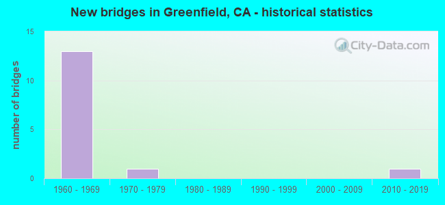
- New bridges - historical statistics
- 131960-1969
- 11970-1979
- 12010-2019


- Bridge Condition - Deck
- 77.8%Good
- 11.1%Satisfactory
- 11.1%Fair

- Bridge Condition - Superstructure
- 77.8%Good
- 22.2%Satisfactory

- Bridge Condition - Channel
- 25.0%Excellent
- 75.0%Good
Find on map >> Show street view
Structure Number: 44 013, Location: 05-MON-101-R89.27 (Lat: 36.697708, Lng: -121.664967), Route carried "on" structure: County highway H278, Year Built: 1965, Status: Open, Structure Length: 7.44m (24.41ft), Average Daily Traffic: 33,000 (year 2010), Truck Traffic: 5%, Average Future Daily Traffic: 49,855 (year 2038), Design Load: HS 20+Mod, Features Intersected: US HIGHWAY 101, Facility Carried by Structure: W LAUREL DR
Minimum Vertical Clearance: 30+ m (98+ ft), Kilometerpoint: 0.000, Lanes on structure: 4, Lanes under structure: 5, Base Highway Network: Yes, Owner: State Highway Agency, Approaching Roadway Width: 15.8m (51.8ft), Skew: 1 degrees, Material/Design: Concrete continuous, Design/Construction: Box Beam or Girders - Multiple, Number Of Spans In Main Unit: 3, Length of Maximum Span: 32.6m (107.0ft), Curb or Sidewalk Widths: Left: 1.5m (4.9ft), Right: 1.5m (4.9ft), Curb-To-Curb Width: 15.8m (51.8ft), Out-to-Out Width: 19.5m (64.0ft)
Condition: Deck: Good, Superstructure: Good, Substructure: Good, Operating Rating: 40.5 metric tons, Method Used To Determine Operating Rating: Load and Resistance Factor Rating (LRFR) rating reported by rating factor(RF) method using HL-93 loadings, Inventory Rating: 28.8 metric tons, Method Used To Determine Inventory Rating: Load and Resistance Factor Rating (LRFR) rating reported by rating factor(RF) method using HL-93 loadings, Structural Evaluation: Better than present minimum criteria, Deck Geometry: Meets minimum limits, Underclear: Somewhat better than minimum adequacy, Approach Roadway Alignment: Equal to present desirable criteria, Designated Inspection Frequency: Every 24 months, Inspection Date: June 2020, Deck Structure Type: Concrete Cast-file-Place
Find on map >> Show street view
Structure Number: 44 0133, Location: 05-MON-101-52.66 (Lat: 36.314294, Lng: -121.234675), Route carried "on" structure: County highway , Year Built: 1961, Status: Open, Structure Length: 7.35m (24.11ft), Average Daily Traffic: 9,300 (year 2010), Truck Traffic: 5%, Average Future Daily Traffic: 14,039 (year 2042), Design Load: HS 20, Features Intersected: US HIGHWAY 101, Facility Carried by Structure: S GREENFIELD
Minimum Vertical Clearance: 30+ m (98+ ft), Kilometerpoint: 0.000, Lanes on structure: 2, Lanes under structure: 4, Base Highway Network: Yes, Owner: State Highway Agency, Approaching Roadway Width: 8.5m (27.9ft), Skew: 2 degrees, Material/Design: Concrete continuous, Design/Construction: Box Beam or Girders - Multiple, Number Of Spans In Main Unit: 4, Length of Maximum Span: 25.0m (82.0ft), Curb or Sidewalk Widths: Left: 0.6m (2.0ft), Right: 0.6m (2.0ft), Curb-To-Curb Width: 8.5m (27.9ft), Out-to-Out Width: 10.4m (34.1ft)
Condition: Deck: Good, Superstructure: Good, Substructure: Good, Operating Rating: 56.1 metric tons, Method Used To Determine Operating Rating: Load and Resistance Factor Rating (LRFR) rating reported by rating factor(RF) method using HL-93 loadings, Inventory Rating: 43.1 metric tons, Method Used To Determine Inventory Rating: Load and Resistance Factor Rating (LRFR) rating reported by rating factor(RF) method using HL-93 loadings, Structural Evaluation: Better than present minimum criteria, Deck Geometry: Meets minimum limits, Underclear: Somewhat better than minimum adequacy, Approach Roadway Alignment: Equal to present desirable criteria, Designated Inspection Frequency: Every 48 months, Inspection Date: May 2020, Deck Structure Type: Concrete Cast-file-Place
Find on map >> Show street view
Structure Number: 44 0134, Location: 05-MON-101-53.36-GNFD (Lat: 36.323583, Lng: -121.238422), Route carried "on" structure: City street , Year Built: 1961, Status: Open, Structure Length: 5.88m (19.29ft), Average Daily Traffic: 6,220 (year 2010), Truck Traffic: 5%, Average Future Daily Traffic: 9,744 (year 2042), Design Load: HS 20, Features Intersected: US HIGHWAY 101, Facility Carried by Structure: OAK AVENUE
Minimum Vertical Clearance: 30+ m (98+ ft), Kilometerpoint: 0.000, Lanes on structure: 2, Lanes under structure: 4, Owner: State Highway Agency, Approaching Roadway Width: 11.6m (38.1ft), Material/Design: Concrete continuous, Design/Construction: Box Beam or Girders - Multiple, Number Of Spans In Main Unit: 4, Length of Maximum Span: 18.3m (60.0ft), Curb or Sidewalk Widths: Left: 1.5m (4.9ft), Right: 1.5m (4.9ft), Curb-To-Curb Width: 8.5m (27.9ft), Out-to-Out Width: 12.2m (40.0ft)
Condition: Deck: Good, Superstructure: Good, Substructure: Good, Operating Rating: 45.4 metric tons, Method Used To Determine Operating Rating: Load and Resistance Factor Rating (LRFR) rating reported by rating factor(RF) method using HL-93 loadings, Inventory Rating: 35.0 metric tons, Method Used To Determine Inventory Rating: Load and Resistance Factor Rating (LRFR) rating reported by rating factor(RF) method using HL-93 loadings, Structural Evaluation: Better than present minimum criteria, Deck Geometry: High priority of replacement, Underclear: Somewhat better than minimum adequacy, Approach Roadway Alignment: Equal to present desirable criteria, Designated Inspection Frequency: Every 48 months, Inspection Date: May 2020, Deck Structure Type: Concrete Cast-file-Place
Find on map >> Show street view
Structure Number: 44 0135, Location: 05-MON-101-53.86 (Lat: 36.329194, Lng: -121.244100), Route carried "on" structure: County highway , Year Built: 1961, Status: Open, Structure Length: 5.88m (19.29ft), Average Daily Traffic: 2,300 (year 2010), Truck Traffic: 5%, Average Future Daily Traffic: 5,434 (year 2036), Design Load: HS 20, Features Intersected: US HIGHWAY 101, Facility Carried by Structure: WALNUT AVE
Minimum Vertical Clearance: 30+ m (98+ ft), Kilometerpoint: 0.000, Lanes on structure: 2, Lanes under structure: 4, Owner: State Highway Agency, Approaching Roadway Width: 8.5m (27.9ft), Skew: 1 degrees, Material/Design: Concrete continuous, Design/Construction: Box Beam or Girders - Multiple, Number Of Spans In Main Unit: 4, Length of Maximum Span: 18.3m (60.0ft), Curb or Sidewalk Widths: Left: 1.5m (4.9ft), Right: 1.5m (4.9ft), Curb-To-Curb Width: 8.5m (27.9ft), Out-to-Out Width: 12.2m (40.0ft)
Condition: Deck: Good, Superstructure: Good, Substructure: Good, Operating Rating: 45.7 metric tons, Method Used To Determine Operating Rating: Load and Resistance Factor Rating (LRFR) rating reported by rating factor(RF) method using HL-93 loadings, Inventory Rating: 35.3 metric tons, Method Used To Determine Inventory Rating: Load and Resistance Factor Rating (LRFR) rating reported by rating factor(RF) method using HL-93 loadings, Structural Evaluation: Better than present minimum criteria, Deck Geometry: Meets minimum limits, Underclear: Somewhat better than minimum adequacy, Approach Roadway Alignment: Equal to present desirable criteria, Designated Inspection Frequency: Every 48 months, Inspection Date: May 2018, Deck Structure Type: Concrete Cast-file-Place
Find on map >> Show street view
Structure Number: 44 0136, Location: 05-MON-101-54.79 (Lat: 36.339114, Lng: -121.255022), Route carried "on" structure: County highway , Year Built: 1961, Status: Open, Structure Length: 6.63m (21.75ft), Average Daily Traffic: 2,833 (year 2009), Truck Traffic: 10%, Average Future Daily Traffic: 3,473 (year 2036), Design Load: HS 20, Features Intersected: US HIGHWAY 101, Facility Carried by Structure: EL CAMINO REAL
Minimum Vertical Clearance: 30+ m (98+ ft), Kilometerpoint: 0.000, Lanes on structure: 2, Lanes under structure: 4, Base Highway Network: Yes, Owner: State Highway Agency, Approaching Roadway Width: 8.5m (27.9ft), Skew: 3 degrees, Material/Design: Concrete continuous, Design/Construction: Box Beam or Girders - Multiple, Number Of Spans In Main Unit: 4, Length of Maximum Span: 21.3m (69.9ft), Curb or Sidewalk Widths: Left: 0.6m (2.0ft), Right: 0.6m (2.0ft), Curb-To-Curb Width: 8.5m (27.9ft), Out-to-Out Width: 10.4m (34.1ft)
Condition: Deck: Good, Superstructure: Good, Substructure: Good, Operating Rating: 57.0 metric tons, Method Used To Determine Operating Rating: Load and Resistance Factor Rating (LRFR) rating reported by rating factor(RF) method using HL-93 loadings, Inventory Rating: 43.7 metric tons, Method Used To Determine Inventory Rating: Load and Resistance Factor Rating (LRFR) rating reported by rating factor(RF) method using HL-93 loadings, Structural Evaluation: Better than present minimum criteria, Deck Geometry: Meets minimum limits, Underclear: High priority of corrective action, Approach Roadway Alignment: Equal to present desirable criteria, Designated Inspection Frequency: Every 48 months, Inspection Date: May 2018, Deck Structure Type: Concrete Cast-file-Place
Find on map >> Show street view
Structure Number: 44 0166, Location: 05-MON-101-53.11-GNFD (Lat: 36.320400, Lng: -121.236136), Route carried "on" structure: City street , Year Built: 1961, Status: Open, Structure Length: 5.94m (19.49ft), Average Daily Traffic: 3,700 (year 2010), Truck Traffic: 5%, Average Future Daily Traffic: 5,452 (year 2042), Design Load: HS 20, Features Intersected: US HIGHWAY 101, Facility Carried by Structure: ELM AVE
Minimum Vertical Clearance: 30+ m (98+ ft), Kilometerpoint: 0.000, Lanes on structure: 2, Lanes under structure: 4, Owner: State Highway Agency, Approaching Roadway Width: 12.8m (42.0ft), Skew: 1 degrees, Material/Design: Concrete continuous, Design/Construction: Box Beam or Girders - Multiple, Number Of Spans In Main Unit: 4, Length of Maximum Span: 18.6m (61.0ft), Curb or Sidewalk Widths: Left: 1.5m (4.9ft), Right: 1.5m (4.9ft), Curb-To-Curb Width: 8.5m (27.9ft), Out-to-Out Width: 12.2m (40.0ft)
Condition: Deck: Good, Superstructure: Satisfactory, Substructure: Good, Operating Rating: 61.6 metric tons, Method Used To Determine Operating Rating: Load and Resistance Factor Rating (LRFR) rating reported by rating factor(RF) method using HL-93 loadings, Inventory Rating: 44.1 metric tons, Method Used To Determine Inventory Rating: Load and Resistance Factor Rating (LRFR) rating reported by rating factor(RF) method using HL-93 loadings, Structural Evaluation: Equal to present minimum criteria, Deck Geometry: Meets minimum limits, Underclear: Somewhat better than minimum adequacy, Approach Roadway Alignment: Equal to present desirable criteria, Designated Inspection Frequency: Every 24 months, Inspection Date: May 2020, Deck Structure Type: Concrete Cast-file-Place
Find on map >> Show street view
Structure Number: 44C0031, Location: 1.1 MI N OF ELM AVE (Lat: 36.353503, Lng: -121.208897), Route carried "on" structure: County highway , Year Built: 1976, Status: Open, Structure Length: 5.67m (18.60ft), Average Daily Traffic: 940 (year 2016), Truck Traffic: 5%, Average Future Daily Traffic: 2,200 (year 2037), Design Load: HS 20, Features Intersected: CHALONE CREEK, Facility Carried by Structure: METZ RD
Minimum Vertical Clearance: 30+ m (98+ ft), Kilometerpoint: 0.000, Lanes on structure: 2, Owner: County Highway Agency, Approaching Roadway Width: 9.6m (31.5ft), Skew: 1 degrees, Material/Design: Concrete continuous, Design/Construction: Slab, Number Of Spans In Main Unit: 6, Length of Maximum Span: 10.4m (34.1ft), Curb or Sidewalk Widths: Left: 0.2m (0.7ft), Right: 0.2m (0.7ft), Curb-To-Curb Width: 9.6m (31.5ft), Out-to-Out Width: 9.9m (32.5ft)
Condition: Deck: Satisfactory, Superstructure: Satisfactory, Substructure: Good, Channel: Good, Operating Rating: 86.5 metric tons, Method Used To Determine Operating Rating: Load Factor (LF), Inventory Rating: 52.2 metric tons, Method Used To Determine Inventory Rating: Load Factor (LF), Structural Evaluation: Equal to present minimum criteria, Deck Geometry: Equal to present minimum criteria, Waterway Adequacy: Equal to present minimum criteria, Approach Roadway Alignment: Equal to present desirable criteria, Designated Inspection Frequency: Every 48 months, Inspection Date: April 2020, Deck Structure Type: Concrete Cast-file-Place
Find on map >> Show street view
Structure Number: 44C0056, Location: 0.1 MI W METZ RD (Lat: 36.337706, Lng: -121.205125), Route carried "on" structure: County highway , Year Built: 1968, Status: Open, Structure Length: 3.69m (12.11ft), Average Daily Traffic: 1,900 (year 2017), Truck Traffic: 5%, Average Future Daily Traffic: 4,000 (year 2037), Design Load: HS 20, Features Intersected: SALINAS RIVER, Facility Carried by Structure: ELM AVE
Minimum Vertical Clearance: 30+ m (98+ ft), Kilometerpoint: 0.000, Lanes on structure: 2, Owner: County Highway Agency, Approaching Roadway Width: 8.4m (27.6ft), Material/Design: Prestressed concrete, Design/Construction: Stringer/Multi-beam, Number Of Spans In Main Unit: 2, Length of Maximum Span: 18.3m (60.0ft), Curb-To-Curb Width: 8.5m (27.9ft), Out-to-Out Width: 8.7m (28.5ft)
Condition: Deck: Fair, Superstructure: Good, Substructure: Good, Channel: Good, Operating Rating: 35.0 metric tons, Method Used To Determine Operating Rating: Load and Resistance Factor Rating (LRFR) rating reported by rating factor(RF) method using HL-93 loadings, Inventory Rating: 24.0 metric tons, Method Used To Determine Inventory Rating: Load and Resistance Factor Rating (LRFR) rating reported by rating factor(RF) method using HL-93 loadings, Structural Evaluation: Equal to present minimum criteria, Deck Geometry: Somewhat better than minimum adequacy, Waterway Adequacy: Somewhat better than minimum adequacy, Approach Roadway Alignment: Equal to present desirable criteria, Designated Inspection Frequency: Every 24 months, Inspection Date: April 2020, Deck Structure Type: Concrete Cast-file-Place
Find on map >> Show street view
Structure Number: 44C0127, Location: AT PEACH ROAD (Lat: 36.318772, Lng: -121.280781), Route carried "on" structure: County highway , Year Built: 1962, Status: Open, Structure Length: 0.71m (2.33ft), Average Daily Traffic: 140 (year 2016), Truck Traffic: 2%, Average Future Daily Traffic: 429 (year 2037), Features Intersected: CLARK COLONY WATER CANAL, Facility Carried by Structure: PINE AVE
Minimum Vertical Clearance: 30+ m (98+ ft), Kilometerpoint: 0.000, Lanes on structure: 2, Owner: County Highway Agency, Approaching Roadway Width: 9.0m (29.5ft), Skew: 2 degrees, Material/Design: Concrete continuous, Design/Construction: Culvert, Number Of Spans In Main Unit: 1, Length of Maximum Span: 7.1m (23.3ft), Curb-To-Curb Width: 9.0m (29.5ft), Out-to-Out Width: 9.4m (30.8ft)
Condition: Channel: Good, Culverts: Satisfactory, Operating Rating: 40.5 metric tons, Method Used To Determine Operating Rating: Field evaluation and documented engineering judgment, Inventory Rating: 24.3 metric tons, Method Used To Determine Inventory Rating: Field evaluation and documented engineering judgment, Structural Evaluation: Equal to present minimum criteria, Deck Geometry: Equal to present minimum criteria, Waterway Adequacy: Equal to present desirable criteria, Approach Roadway Alignment: Equal to present desirable criteria, Designated Inspection Frequency: Every 24 months, Inspection Date: April 2020, Deck Structure Type: Concrete Cast-file-Place
Find on map >> Show street view
Structure Number: 44C0183, Location: 2 MI WEST OF SR 101 (Lat: 36.322375, Lng: -121.294008), Route carried "on" structure: County highway , Year Built: 2010, Status: Open, Structure Length: 18.29m (60.01ft), Average Daily Traffic: 1,200 (year 2016), Truck Traffic: 1%, Average Future Daily Traffic: 1,041 (year 2037), Design Load: HS 20+Mod, Features Intersected: ARROYO SECO RIVER, Facility Carried by Structure: THORNE ROAD
Minimum Vertical Clearance: 30+ m (98+ ft), Kilometerpoint: 0.000, Lanes on structure: 2, Owner: County Highway Agency, Approaching Roadway Width: 12.2m (40.0ft), Skew: 5 degrees, Material/Design: Prestressed concrete continuous, Design/Construction: Box Beam or Girders - Multiple, Number Of Spans In Main Unit: 4, Length of Maximum Span: 45.7m (149.9ft), Curb-To-Curb Width: 12.2m (40.0ft), Out-to-Out Width: 13.1m (43.0ft)
Condition: Deck: Good, Superstructure: Good, Substructure: Good, Channel: Excellent, Operating Rating: 54.1 metric tons, Method Used To Determine Operating Rating: Assigned rating based on Load Factor Design (LFD) reported in metric tons, Inventory Rating: 32.4 metric tons, Method Used To Determine Inventory Rating: Assigned rating based on Load Factor Design (LFD) reported in metric tons, Structural Evaluation: Better than present minimum criteria, Deck Geometry: Better than present minimum criteria, Waterway Adequacy: Superior to present desirable criteria, Approach Roadway Alignment: Equal to present desirable criteria, Designated Inspection Frequency: Every 24 months, Inspection Date: April 2020, Deck Structure Type: Concrete Cast-file-Place
Find on map >> Show street view
Structure Number: 44 0133, Location: 05-MON-101-52.66 (Lat: 36.314294, Lng: -121.234675), Route carried "under" structure: US 101, Year Built: 1961, Structure Length: 0. m, Average Daily Traffic: 30,200 (year 2010), Truck Traffic: 13%, Features Intersected: US HIGHWAY 101, Facility Carried by Structure: S GREENFIELD
Minimum Vertical Clearance: 5.43m (17.81ft), Kilometerpoint: 52.660, Lanes on structure: 2, Lanes under structure: 4, Material/Design: Concrete continuous, Design/Construction: Box Beam or Girders - Multiple, Length of Maximum Span: 25.0m (82.0ft)
Find on map >> Show street view
Structure Number: 44 0134, Location: 05-MON-101-53.36-GNFD (Lat: 36.323583, Lng: -121.238422), Route carried "under" structure: US 101, Year Built: 1961, Structure Length: 0. m, Average Daily Traffic: 43,000 (year 2010), Truck Traffic: 13%, Features Intersected: US HIGHWAY 101, Facility Carried by Structure: OAK AVENUE
Minimum Vertical Clearance: 4.69m (15.39ft), Kilometerpoint: 53.360, Lanes on structure: 2, Lanes under structure: 4, Material/Design: Concrete continuous, Design/Construction: Box Beam or Girders - Multiple, Length of Maximum Span: 18.3m (60.0ft)
Find on map >> Show street view
Structure Number: 44 0135, Location: 05-MON-101-53.86 (Lat: 36.329194, Lng: -121.244100), Route carried "under" structure: US 101, Year Built: 1961, Structure Length: 0. m, Average Daily Traffic: 33,000 (year 2010), Truck Traffic: 13%, Features Intersected: US HIGHWAY 101, Facility Carried by Structure: WALNUT AVE
Minimum Vertical Clearance: 4.67m (15.32ft), Kilometerpoint: 53.860, Lanes on structure: 2, Lanes under structure: 4, Material/Design: Concrete continuous, Design/Construction: Box Beam or Girders - Multiple, Length of Maximum Span: 18.3m (60.0ft)
Find on map >> Show street view
Structure Number: 44 0136, Location: 05-MON-101-54.79 (Lat: 36.339114, Lng: -121.255022), Route carried "under" structure: US 101, Year Built: 1961, Structure Length: 0. m, Average Daily Traffic: 33,000 (year 2010), Truck Traffic: 10%, Features Intersected: US HIGHWAY 101, Facility Carried by Structure: EL CAMINO REAL
Minimum Vertical Clearance: 4.82m (15.81ft), Kilometerpoint: 54.790, Lanes on structure: 2, Lanes under structure: 4, Material/Design: Concrete continuous, Design/Construction: Box Beam or Girders - Multiple, Length of Maximum Span: 21.3m (69.9ft)
Find on map >> Show street view
Structure Number: 44 0166, Location: 05-MON-101-53.11-GNFD (Lat: 36.320400, Lng: -121.236136), Route carried "under" structure: US 101, Year Built: 1961, Structure Length: 0. m, Average Daily Traffic: 38,000 (year 2010), Truck Traffic: 13%, Features Intersected: US HIGHWAY 101, Facility Carried by Structure: ELM AVE
Minimum Vertical Clearance: 5.33m (17.49ft), Kilometerpoint: 53.110, Lanes on structure: 2, Lanes under structure: 4, Material/Design: Concrete continuous, Design/Construction: Box Beam or Girders - Multiple, Length of Maximum Span: 18.6m (61.0ft)