Bridge Statistics for Greenacres, Florida (FL)
Condition, Traffic, Stress, Structural Evaluation, Project Costs
- National Bridge Inventory (NBI) Statistics
- 16Number of bridges
- 98ft / 29.7mTotal length
- $180,000Total costs
- 347,398Total average daily traffic
- 24,385Total average daily truck traffic
- 629,681Total future (year 2040) average daily traffic
- National Bridge Inventory (NBI) Registered Bridges for Greenacres
- No street view available for this location
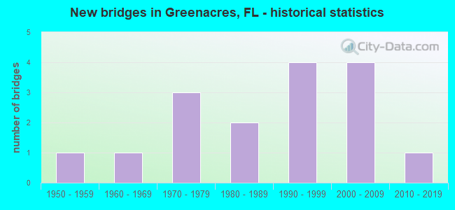
- New bridges - historical statistics
- 11950-1959
- 11960-1969
- 31970-1979
- 21980-1989
- 41990-1999
- 42000-2009
- 12010-2019

- Reconstructed bridges - Historical Statistics
- 11980-1989
- 11990-1999
- 02000-2009
- 12010-2019


- Bridge Condition - Deck
- 6.3%Excellent
- 18.8%Very good
- 62.5%Good
- 12.5%Fair

- Bridge Condition - Superstructure
- 6.3%Excellent
- 18.8%Very good
- 62.5%Good
- 12.5%Fair

- Bridge Condition - Substructure
- 6.3%Excellent
- 31.3%Very good
- 62.5%Good

- Bridge Condition - Channel
- 6.3%Excellent
- 37.5%Very good
- 37.5%Good
- 18.8%Satisfactory
Find on map >> Show street view
Structure Number: 930223, Location: 1.2 MI NO OF LANTANA RD (Lat: 26.602406, Lng: -80.173528), Route carried "on" structure: State highway 91, Year Built: 1956, Year Reconstructed: 1990, Status: Open, Structure Length: 2.50m (8.20ft), Average Daily Traffic: 71,600 (year 2021), Truck Traffic: 16%, Average Future Daily Traffic: 124,226 (year 2042), Design Load: HS 20+Mod, Features Intersected: LATERAL CANAL #38
Minimum Vertical Clearance: 30+ m (98+ ft), Kilometerpoint: 30.383, Lanes on structure: 4, Base Highway Network: Yes, Toll: On toll road, Owner: State Toll Authority, Approaching Roadway Width: 25.9m (85.0ft), Skew: 30 degrees, Material/Design: Concrete, Design/Construction: Tee Beam, Number Of Spans In Main Unit: 1, Number Of Approach Spans: 2, Length of Maximum Span: 14.6m (47.9ft), Curb-To-Curb Width: 26.2m (86.0ft), Out-to-Out Width: 27.7m (90.9ft)
Condition: Deck: Good, Superstructure: Good, Substructure: Good, Channel: Very good, Operating Rating: 35.7 metric tons, Method Used To Determine Operating Rating: Load Factor (LF), Inventory Rating: 21.4 metric tons, Method Used To Determine Inventory Rating: Load Factor (LF), Structural Evaluation: Somewhat better than minimum adequacy, Deck Geometry: Superior to present desirable criteria, Waterway Adequacy: Equal to present minimum criteria, Approach Roadway Alignment: Equal to present desirable criteria, Length Of Structure Improvement: 2.47m (8.10ft), Designated Inspection Frequency: Every 24 months, Inspection Date: October 2021, Bridge Improvement Cost: $180,000, Total Project Cost: $180,000, Deck Structure Type: Concrete Cast-file-Place, Wearing Surface/Protective System: Wearing Surface: Bituminous, Membrane: Built-up
Find on map >> Show street view
Structure Number: 930328, Location: 1mi. east of Jog Rd. (Lat: 26.619200, Lng: -80.129961), Route carried "on" structure: State highway 802, Year Built: 1978, Status: Open, Structure Length: 1.75m (5.74ft), Average Daily Traffic: 24,000 (year 2018), Truck Traffic: 8%, Average Future Daily Traffic: 41,640 (year 2040), Design Load: HS 20, Features Intersected: E-3 CANAL, Facility Carried by Structure: WB Lake Worth Rd.
Minimum Vertical Clearance: 30+ m (98+ ft), Kilometerpoint: 7.490, Lanes on structure: 3, Base Highway Network: Yes, Owner: State Highway Agency, Approaching Roadway Width: 14.3m (46.9ft), Material/Design: Prestressed concrete, Design/Construction: Slab, Number Of Spans In Main Unit: 3, Length of Maximum Span: 8.1m (26.6ft), Curb or Sidewalk Widths: Left: 1.5m (4.9ft), Right: 0.0m, Curb-To-Curb Width: 14.3m (46.9ft), Out-to-Out Width: 15.2m (49.9ft)
Condition: Deck: Good, Superstructure: Good, Substructure: Good, Channel: Good, Operating Rating: 78.4 metric tons, Method Used To Determine Operating Rating: Load Factor (LF), Inventory Rating: 47.0 metric tons, Method Used To Determine Inventory Rating: Load Factor (LF), Structural Evaluation: Better than present minimum criteria, Deck Geometry: Somewhat better than minimum adequacy, Waterway Adequacy: Superior to present desirable criteria, Approach Roadway Alignment: Equal to present desirable criteria, Designated Inspection Frequency: Every 24 months, Underwater Inspection Frequency: Every 24 months, Inspection Date: March 2021, Underwater Inspection Date: March 2021, Deck Structure Type: Concrete Precast Panels, Wearing Surface/Protective System: Wearing Surface: Bituminous
Find on map >> Show street view
Structure Number: 930329, Location: 1 Mile East of Jog Rd. (Lat: 26.618900, Lng: -80.130144), Route carried "on" structure: State highway 802, Year Built: 1979, Status: Open, Structure Length: 1.75m (5.74ft), Average Daily Traffic: 24,000 (year 2018), Truck Traffic: 8%, Average Future Daily Traffic: 41,640 (year 2040), Design Load: HS 20, Features Intersected: E-3 CANAL, Facility Carried by Structure: EB Lake Worth Rd.
Minimum Vertical Clearance: 30+ m (98+ ft), Kilometerpoint: 7.490, Lanes on structure: 3, Base Highway Network: Yes, Owner: State Highway Agency, Approaching Roadway Width: 10.7m (35.1ft), Material/Design: Prestressed concrete, Design/Construction: Slab, Number Of Spans In Main Unit: 3, Length of Maximum Span: 8.1m (26.6ft), Curb or Sidewalk Widths: Left: 0.0m, Right: 1.5m (4.9ft), Curb-To-Curb Width: 14.3m (46.9ft), Out-to-Out Width: 15.0m (49.2ft)
Condition: Deck: Good, Superstructure: Good, Substructure: Very good, Channel: Satisfactory, Operating Rating: 78.4 metric tons, Method Used To Determine Operating Rating: Load Factor (LF), Inventory Rating: 47.0 metric tons, Method Used To Determine Inventory Rating: Load Factor (LF), Structural Evaluation: Better than present minimum criteria, Deck Geometry: Somewhat better than minimum adequacy, Waterway Adequacy: Superior to present desirable criteria, Approach Roadway Alignment: Equal to present desirable criteria, Designated Inspection Frequency: Every 24 months, Underwater Inspection Frequency: Every 24 months, Inspection Date: March 2021, Underwater Inspection Date: March 2021, Deck Structure Type: Concrete Precast Panels, Wearing Surface/Protective System: Wearing Surface: Bituminous
Find on map >> Show street view
Structure Number: 934271, Location: 0.6MI S of SOUTHERN BLVD (Lat: 26.670167, Lng: -80.145208), Route carried "on" structure: County highway , Year Built: 1993, Status: Open, Structure Length: 1.68m (5.51ft), Average Daily Traffic: 12,500 (year 2020), Truck Traffic: 5%, Average Future Daily Traffic: 73,000 (year 2042), Design Load: HS 20, Features Intersected: L-5 CANAL, Facility Carried by Structure: JOG ROAD (SB)
Minimum Vertical Clearance: 30+ m (98+ ft), Kilometerpoint: 15.879, Lanes on structure: 3, Base Highway Network: Yes, Owner: County Highway Agency, Approaching Roadway Width: 13.4m (44.0ft), Skew: 1 degrees, Material/Design: Prestressed concrete, Design/Construction: Stringer/Multi-beam, Number Of Spans In Main Unit: 1, Length of Maximum Span: 16.8m (55.1ft), Curb or Sidewalk Widths: Left: 1.9m (6.2ft), Right: 0.0m, Curb-To-Curb Width: 13.2m (43.3ft), Out-to-Out Width: 17.5m (57.4ft)
Condition: Deck: Very good, Superstructure: Very good, Substructure: Very good, Channel: Very good, Operating Rating: 79.7 metric tons, Method Used To Determine Operating Rating: Load Factor (LF), Inventory Rating: 47.8 metric tons, Method Used To Determine Inventory Rating: Load Factor (LF), Structural Evaluation: Equal to present desirable criteria, Deck Geometry: Somewhat better than minimum adequacy, Waterway Adequacy: Better than present minimum criteria, Approach Roadway Alignment: Better than present minimum criteria, Designated Inspection Frequency: Every 24 months, Inspection Date: September 2020, Deck Structure Type: Concrete Cast-file-Place
Find on map >> Show street view
Structure Number: 934272, Location: 0.6MI S of SOUTHERN BLVD (Lat: 26.670222, Lng: -80.145028), Route carried "on" structure: County highway , Year Built: 1993, Status: Open, Structure Length: 1.68m (5.51ft), Average Daily Traffic: 35,500 (year 2020), Truck Traffic: 2%, Average Future Daily Traffic: 61,593 (year 2042), Design Load: HS 20, Features Intersected: L-5 CANAL, Facility Carried by Structure: JOG ROAD (NB)
Minimum Vertical Clearance: 30+ m (98+ ft), Kilometerpoint: 15.879, Lanes on structure: 3, Base Highway Network: Yes, Owner: County Highway Agency, Approaching Roadway Width: 13.4m (44.0ft), Skew: 1 degrees, Material/Design: Prestressed concrete, Design/Construction: Stringer/Multi-beam, Number Of Spans In Main Unit: 1, Length of Maximum Span: 16.8m (55.1ft), Curb or Sidewalk Widths: Left: 0.0m, Right: 1.9m (6.2ft), Curb-To-Curb Width: 13.2m (43.3ft), Out-to-Out Width: 17.5m (57.4ft)
Condition: Deck: Very good, Superstructure: Very good, Substructure: Very good, Channel: Very good, Operating Rating: 79.7 metric tons, Method Used To Determine Operating Rating: Load Factor (LF), Inventory Rating: 47.8 metric tons, Method Used To Determine Inventory Rating: Load Factor (LF), Structural Evaluation: Equal to present desirable criteria, Deck Geometry: Somewhat better than minimum adequacy, Waterway Adequacy: Better than present minimum criteria, Approach Roadway Alignment: Better than present minimum criteria, Designated Inspection Frequency: Every 24 months, Inspection Date: September 2020, Deck Structure Type: Concrete Cast-file-Place
Find on map >> Show street view
Structure Number: 934312, Location: 0.2MI S of FOREST HILL BV (Lat: 26.648500, Lng: -80.132856), Route carried "on" structure: City street , Year Built: 1960, Status: Open, Structure Length: 1.37m (4.49ft), Average Daily Traffic: 3,450 (year 2020), Truck Traffic: 4%, Average Future Daily Traffic: 5,205 (year 2042), Design Load: HS 15, Features Intersected: LWDD LAT 8 CANAL, Facility Carried by Structure: KUDZA ROAD
Minimum Vertical Clearance: 30+ m (98+ ft), Kilometerpoint: 0.000, Lanes on structure: 2, Owner: County Highway Agency, Approaching Roadway Width: 6.1m (20.0ft), Material/Design: Concrete, Design/Construction: Slab, Number Of Spans In Main Unit: 3, Length of Maximum Span: 4.6m (15.1ft), Curb or Sidewalk Widths: Left: 0.5m (1.6ft), Right: 1.0m (3.3ft), Curb-To-Curb Width: 8.5m (27.9ft), Out-to-Out Width: 10.8m (35.4ft)
Condition: Deck: Good, Superstructure: Good, Substructure: Good, Channel: Good, Operating Rating: 25.6 metric tons, Method Used To Determine Operating Rating: Load and Resistance Factor (LRFR), Inventory Rating: 12.6 metric tons, Method Used To Determine Inventory Rating: Load and Resistance Factor (LRFR), Structural Evaluation: Meets minimum limits, Deck Geometry: Meets minimum limits, Waterway Adequacy: Equal to present minimum criteria, Approach Roadway Alignment: Equal to present desirable criteria, Designated Inspection Frequency: Every 24 months, Inspection Date: June 2020, Deck Structure Type: Concrete Precast Panels
Find on map >> Show street view
Structure Number: 934315, Location: 0.8 MI N of LANTANA ROAD (Lat: 26.602650, Lng: -80.147092), Route carried "on" structure: County highway , Year Built: 1993, Status: Open, Structure Length: 2.29m (7.51ft), Average Daily Traffic: 36,000 (year 2020), Truck Traffic: 2%, Average Future Daily Traffic: 62,460 (year 2042), Design Load: HS 20, Features Intersected: L-14 CANAL, Facility Carried by Structure: JOG ROAD
Minimum Vertical Clearance: 30+ m (98+ ft), Kilometerpoint: 8.390, Lanes on structure: 6, Base Highway Network: Yes, Owner: County Highway Agency, Approaching Roadway Width: 25.1m (82.3ft), Skew: 20 degrees, Material/Design: Prestressed concrete, Design/Construction: Slab, Number Of Spans In Main Unit: 3, Length of Maximum Span: 7.6m (24.9ft), Curb or Sidewalk Widths: Left: 2.0m (6.6ft), Right: 2.0m (6.6ft), Curb-To-Curb Width: 25.1m (82.3ft), Out-to-Out Width: 35.1m (115.2ft)
Condition: Deck: Very good, Superstructure: Very good, Substructure: Good, Channel: Good, Operating Rating: 74.4 metric tons, Method Used To Determine Operating Rating: Load Factor (LF), Inventory Rating: 44.5 metric tons, Method Used To Determine Inventory Rating: Load Factor (LF), Structural Evaluation: Better than present minimum criteria, Deck Geometry: Somewhat better than minimum adequacy, Waterway Adequacy: Equal to present minimum criteria, Approach Roadway Alignment: Equal to present desirable criteria, Designated Inspection Frequency: Every 24 months, Underwater Inspection Frequency: Every 24 months, Inspection Date: August 2020, Underwater Inspection Date: August 2020, Deck Structure Type: Concrete Precast Panels, Wearing Surface/Protective System: Wearing Surface: Bituminous
Find on map >> Show street view
Structure Number: 934326, Location: 0.5MI W OF HAVERHILL ROAD (Lat: 26.636764, Lng: -80.129242), Route carried "on" structure: City street , Year Built: 1972, Status: Open, Structure Length: 2.40m (7.87ft), Average Daily Traffic: 8,100 (year 2020), Truck Traffic: 2%, Average Future Daily Traffic: 14,054 (year 2042), Design Load: HS 20, Features Intersected: LWDD E-3 CANAL, Facility Carried by Structure: CRESTHAVEN BLVD
Minimum Vertical Clearance: 30+ m (98+ ft), Kilometerpoint: 1.670, Lanes on structure: 2, Owner: County Highway Agency, Approaching Roadway Width: 7.5m (24.6ft), Material/Design: Prestressed concrete, Design/Construction: Slab, Number Of Spans In Main Unit: 3, Length of Maximum Span: 8.0m (26.2ft), Curb or Sidewalk Widths: Left: 1.2m (3.9ft), Right: 1.2m (3.9ft), Curb-To-Curb Width: 8.6m (28.2ft), Out-to-Out Width: 11.7m (38.4ft)
Condition: Deck: Good, Superstructure: Good, Substructure: Good, Channel: Good, Operating Rating: 87.6 metric tons, Method Used To Determine Operating Rating: Allowable Stress (AS), Inventory Rating: 55.9 metric tons, Method Used To Determine Inventory Rating: Allowable Stress (AS), Structural Evaluation: Better than present minimum criteria, Deck Geometry: High priority of replacement, Waterway Adequacy: Better than present minimum criteria, Approach Roadway Alignment: Equal to present desirable criteria, Designated Inspection Frequency: Every 24 months, Underwater Inspection Frequency: Every 24 months, Inspection Date: June 2020, Underwater Inspection Date: June 2020, Deck Structure Type: Concrete Precast Panels, Wearing Surface/Protective System: Wearing Surface: Bituminous
Find on map >> Show street view
Structure Number: 934329, Location: 1.5mi E of Jog Rd. (Lat: 26.651950, Lng: -80.128672), Route carried "on" structure: State highway 882, Year Built: 1989, Year Reconstructed: 1992, Status: Open, Structure Length: 2.38m (7.81ft), Average Daily Traffic: 39,000 (year 2021), Truck Traffic: 3%, Average Future Daily Traffic: 67,665 (year 2042), Design Load: HS 20, Features Intersected: E-3 Canal, Facility Carried by Structure: Forest Hill Blvd.
Minimum Vertical Clearance: 30+ m (98+ ft), Kilometerpoint: 7.466, Lanes on structure: 6, Base Highway Network: Yes, Owner: State Highway Agency, Approaching Roadway Width: 29.6m (97.1ft), Skew: 20 degrees, Material/Design: Prestressed concrete, Design/Construction: Slab, Number Of Spans In Main Unit: 3, Length of Maximum Span: 11.6m (38.1ft), Curb or Sidewalk Widths: Left: 1.5m (4.9ft), Right: 1.5m (4.9ft), Curb-To-Curb Width: 29.6m (97.1ft), Out-to-Out Width: 33.6m (110.2ft)
Condition: Deck: Good, Superstructure: Good, Substructure: Good, Channel: Satisfactory, Operating Rating: 49.6 metric tons, Method Used To Determine Operating Rating: Load Factor (LF), Inventory Rating: 29.0 metric tons, Method Used To Determine Inventory Rating: Load Factor (LF), Structural Evaluation: Better than present minimum criteria, Deck Geometry: Superior to present desirable criteria, Waterway Adequacy: Superior to present desirable criteria, Approach Roadway Alignment: Equal to present desirable criteria, Designated Inspection Frequency: Every 24 months, Underwater Inspection Frequency: Every 24 months, Inspection Date: July 2021, Underwater Inspection Date: July 2021, Deck Structure Type: Concrete Precast Panels, Wearing Surface/Protective System: Wearing Surface: Bituminous
Find on map >> Show street view
Structure Number: 934348, Location: 0.9MI W OF MILITARY TRAIL (Lat: 26.631325, Lng: -80.129503), Route carried "on" structure: County highway , Year Built: 1990, Status: Open, Structure Length: 1.37m (4.49ft), Average Daily Traffic: 13,300 (year 2020), Truck Traffic: 3%, Average Future Daily Traffic: 23,076 (year 2042), Design Load: HS 20, Features Intersected: LWDD E-3 CANAL, Facility Carried by Structure: 10TH AVE NORTH
Minimum Vertical Clearance: 30+ m (98+ ft), Kilometerpoint: 1.646, Lanes on structure: 5, Owner: County Highway Agency, Approaching Roadway Width: 19.6m (64.3ft), Material/Design: Prestressed concrete, Design/Construction: Slab, Number Of Spans In Main Unit: 1, Length of Maximum Span: 13.7m (44.9ft), Curb or Sidewalk Widths: Left: 1.8m (5.9ft), Right: 1.8m (5.9ft), Curb-To-Curb Width: 19.6m (64.3ft), Out-to-Out Width: 27.6m (90.6ft)
Condition: Deck: Fair, Superstructure: Fair, Substructure: Good, Channel: Good, Operating Rating: 60.8 metric tons, Method Used To Determine Operating Rating: Load Factor (LF), Inventory Rating: 36.3 metric tons, Method Used To Determine Inventory Rating: Load Factor (LF), Structural Evaluation: Somewhat better than minimum adequacy, Deck Geometry: Meets minimum limits, Waterway Adequacy: Better than present minimum criteria, Approach Roadway Alignment: Equal to present desirable criteria, Designated Inspection Frequency: Every 24 months, Inspection Date: March 2020, Deck Structure Type: Concrete Precast Panels, Wearing Surface/Protective System: Wearing Surface: Bituminous
Find on map >> Show street view
Structure Number: 934359, Location: 0.4MI S of Melaleuca Ln (Lat: 26.604106, Lng: -80.122286), Route carried "on" structure: City street , Year Built: 2001, Year Reconstructed: 2017, Status: Open, Structure Length: 2.85m (9.35ft), Average Daily Traffic: 13,300 (year 2020), Truck Traffic: 10%, Average Future Daily Traffic: 23,076 (year 2042), Design Load: HL 93, Features Intersected: LWDD L-14 Cnl, Facility Carried by Structure: Haverhill Rd
Minimum Vertical Clearance: 30+ m (98+ ft), Kilometerpoint: 3.570, Lanes on structure: 5, Owner: County Highway Agency, Approaching Roadway Width: 28.5m (93.5ft), Material/Design: Prestressed concrete, Design/Construction: Slab, Number Of Spans In Main Unit: 3, Length of Maximum Span: 11.2m (36.7ft), Curb or Sidewalk Widths: Left: 2.7m (8.9ft), Right: 3.6m (11.8ft), Curb-To-Curb Width: 28.5m (93.5ft), Out-to-Out Width: 29.3m (96.1ft)
Condition: Deck: Good, Superstructure: Good, Substructure: Good, Channel: Good, Operating Rating: 40.2 metric tons, Method Used To Determine Operating Rating: Load and Resistance Factor (LRFR), Inventory Rating: 29.4 metric tons, Method Used To Determine Inventory Rating: Load and Resistance Factor (LRFR), Structural Evaluation: Better than present minimum criteria, Deck Geometry: Superior to present desirable criteria, Waterway Adequacy: Superior to present desirable criteria, Approach Roadway Alignment: Equal to present desirable criteria, Designated Inspection Frequency: Every 24 months, Underwater Inspection Frequency: Every 24 months, Inspection Date: November 2020, Underwater Inspection Date: November 2020, Deck Structure Type: Concrete Precast Panels, Wearing Surface/Protective System: Wearing Surface: Bituminous
Find on map >> Show street view
Structure Number: 934361, Location: 1.1Mi W of Miltiary Trail (Lat: 26.607883, Lng: -80.130383), Route carried "on" structure: City street , Year Built: 2006, Status: Open, Structure Length: 1.16m (3.81ft), Average Daily Traffic: 14,600 (year 2020), Truck Traffic: 10%, Average Future Daily Traffic: 25,331 (year 2042), Design Load: HL 93, Features Intersected: E3-canal, Facility Carried by Structure: Melaleuca Lane
Minimum Vertical Clearance: 30+ m (98+ ft), Kilometerpoint: 1.640, Lanes on structure: 5, Owner: County Highway Agency, Approaching Roadway Width: 19.8m (65.0ft), Material/Design: Prestressed concrete, Design/Construction: Slab, Number Of Spans In Main Unit: 1, Length of Maximum Span: 11.6m (38.1ft), Curb or Sidewalk Widths: Left: 2.3m (7.5ft), Right: 2.3m (7.5ft), Curb-To-Curb Width: 19.8m (65.0ft), Out-to-Out Width: 25.4m (83.3ft)
Condition: Deck: Fair, Superstructure: Fair, Substructure: Very good, Channel: Very good, Operating Rating: 37.9 metric tons, Method Used To Determine Operating Rating: Load and Resistance Factor (LRFR), Inventory Rating: 36.3 metric tons, Method Used To Determine Inventory Rating: Load and Resistance Factor (LRFR), Structural Evaluation: Somewhat better than minimum adequacy, Deck Geometry: Meets minimum limits, Waterway Adequacy: Superior to present desirable criteria, Approach Roadway Alignment: Equal to present desirable criteria, Designated Inspection Frequency: Every 24 months, Underwater Inspection Frequency: Every 24 months, Inspection Date: November 2020, Underwater Inspection Date: November 2020, Deck Structure Type: Concrete Cast-file-Place, Wearing Surface/Protective System: Wearing Surface: Bituminous
Find on map >> Show street view
Structure Number: 934365, Location: 50ft W of TPK (SR-91) (Lat: 26.590406, Lng: -80.173811), Route carried "on" structure: County highway 812, Year Built: 2001, Status: Open, Structure Length: 2.07m (6.79ft), Average Daily Traffic: 22,000 (year 2021), Truck Traffic: 5%, Average Future Daily Traffic: 26,400 (year 2042), Design Load: HS 20+Mod, Features Intersected: LWDD E-2 W, Facility Carried by Structure: Lantana Road
Minimum Vertical Clearance: 30+ m (98+ ft), Kilometerpoint: 3.187, Lanes on structure: 4, Owner: County Highway Agency, Approaching Roadway Width: 24.1m (79.1ft), Skew: 21 degrees, Material/Design: Prestressed concrete, Design/Construction: Slab, Number Of Spans In Main Unit: 3, Length of Maximum Span: 11.6m (38.1ft), Curb or Sidewalk Widths: Left: 2.0m (6.6ft), Right: 2.0m (6.6ft), Curb-To-Curb Width: 24.1m (79.1ft), Out-to-Out Width: 33.6m (110.2ft)
Condition: Deck: Good, Superstructure: Good, Substructure: Good, Channel: Very good, Inventory Rating: 55.1 metric tons, Method Used To Determine Inventory Rating: Load Factor (LF), Structural Evaluation: Better than present minimum criteria, Deck Geometry: Superior to present desirable criteria, Approach Roadway Alignment: Equal to present desirable criteria, Designated Inspection Frequency: Every 24 months, Inspection Date: August 2021, Deck Structure Type: Concrete Precast Panels, Wearing Surface/Protective System: Wearing Surface: Bituminous
Find on map >> Show street view
Structure Number: 934366, Location: 100ft E of Fla Turnpike (Lat: 26.590375, Lng: -80.172889), Route carried "on" structure: County highway 812, Year Built: 2001, Status: Open, Structure Length: 1.16m (3.81ft), Average Daily Traffic: 22,000 (year 2021), Truck Traffic: 5%, Average Future Daily Traffic: 26,400 (year 2042), Design Load: HS 20+Mod, Features Intersected: LWDD E-2E Canal, Facility Carried by Structure: Lantana Road
Minimum Vertical Clearance: 30.45m (99.90ft), Kilometerpoint: 3.281, Lanes on structure: 4, Owner: County Highway Agency, Approaching Roadway Width: 24.1m (79.1ft), Skew: 21 degrees, Material/Design: Prestressed concrete, Design/Construction: Slab, Number Of Spans In Main Unit: 1, Length of Maximum Span: 11.6m (38.1ft), Curb or Sidewalk Widths: Left: 2.0m (6.6ft), Right: 2.0m (6.6ft), Curb-To-Curb Width: 24.1m (79.1ft), Out-to-Out Width: 33.5m (109.9ft)
Condition: Deck: Good, Superstructure: Good, Substructure: Very good, Channel: Very good, Inventory Rating: 57.2 metric tons, Method Used To Determine Inventory Rating: Load Factor (LF), Structural Evaluation: Better than present minimum criteria, Deck Geometry: Superior to present desirable criteria, Approach Roadway Alignment: Equal to present desirable criteria, Designated Inspection Frequency: Every 24 months, Inspection Date: August 2021, Deck Structure Type: Concrete Precast Panels, Wearing Surface/Protective System: Wearing Surface: Bituminous
Find on map >> Show street view
Structure Number: 934368, Location: 1 mi W of SR 809 (Lat: 26.644750, Lng: -80.128844), Route carried "on" structure: County highway , Year Built: 2018, Status: Open, Structure Length: 1.08m (3.54ft), Average Daily Traffic: 7,300 (year 2021), Truck Traffic: 2%, Average Future Daily Traffic: 12,666 (year 2042), Design Load: HL 93, Features Intersected: LWDD E-3 Canal, Facility Carried by Structure: Purdy Lane
Minimum Vertical Clearance: 30.45m (99.90ft), Kilometerpoint: 1.659, Lanes on structure: 4, Base Highway Network: Yes, Owner: County Highway Agency, Approaching Roadway Width: 17.3m (56.8ft), Skew: 20 degrees, Material/Design: Prestressed concrete, Design/Construction: Slab, Number Of Spans In Main Unit: 1, Length of Maximum Span: 10.8m (35.4ft), Curb or Sidewalk Widths: Left: 2.0m (6.6ft), Right: 2.0m (6.6ft), Curb-To-Curb Width: 17.3m (56.8ft), Out-to-Out Width: 22.0m (72.2ft)
Condition: Deck: Excellent, Superstructure: Excellent, Substructure: Excellent, Channel: Excellent, Operating Rating: 49.4 metric tons, Method Used To Determine Operating Rating: Load and Resistance Factor (LRFR), Inventory Rating: 37.2 metric tons, Method Used To Determine Inventory Rating: Load and Resistance Factor (LRFR), Structural Evaluation: Superior to present desirable criteria, Deck Geometry: Somewhat better than minimum adequacy, Waterway Adequacy: Superior to present desirable criteria, Approach Roadway Alignment: Equal to present desirable criteria, Designated Inspection Frequency: Every 24 months, Underwater Inspection Frequency: Every 24 months, Inspection Date: June 2021, Underwater Inspection Date: June 2021, Deck Structure Type: Concrete Precast Panels, Wearing Surface/Protective System: Wearing Surface: Bituminous
Find on map >> Show street view
Structure Number: 93575, Location: 0.5 MI W OF HAVERHILL RD (Lat: 26.626225, Lng: -80.129744), Route carried "on" structure: City street , Year Built: 1980, Status: Open, Structure Length: 2.23m (7.32ft), Average Daily Traffic: 748 (year 2020), Truck Traffic: 4%, Average Future Daily Traffic: 1,249 (year 2042), Design Load: HS 20, Features Intersected: E-3 CANAL, Facility Carried by Structure: BISCAYNE DRIVE
Minimum Vertical Clearance: 30+ m (98+ ft), Kilometerpoint: 0.000, Lanes on structure: 2, Owner: City or Municipal Highway Agency, Approaching Roadway Width: 7.7m (25.3ft), Skew: 1 degrees, Material/Design: Prestressed concrete, Design/Construction: Slab, Number Of Spans In Main Unit: 3, Length of Maximum Span: 9.1m (29.9ft), Curb or Sidewalk Widths: Left: 1.2m (3.9ft), Right: 1.2m (3.9ft), Curb-To-Curb Width: 9.8m (32.2ft), Out-to-Out Width: 13.0m (42.7ft)
Condition: Deck: Good, Superstructure: Good, Substructure: Good, Channel: Satisfactory, Operating Rating: 81.6 metric tons, Method Used To Determine Operating Rating: Load Factor (LF), Inventory Rating: 49.0 metric tons, Method Used To Determine Inventory Rating: Load Factor (LF), Structural Evaluation: Better than present minimum criteria, Deck Geometry: Equal to present minimum criteria, Waterway Adequacy: Better than present minimum criteria, Approach Roadway Alignment: Equal to present desirable criteria, Designated Inspection Frequency: Every 24 months, Underwater Inspection Frequency: Every 24 months, Inspection Date: September 2020, Underwater Inspection Date: September 2020, Deck Structure Type: Concrete Precast Panels, Wearing Surface/Protective System: Wearing Surface: Bituminous