Bridge Statistics for Green Valley, Maryland (MD)
Condition, Traffic, Stress, Structural Evaluation, Project Costs
- National Bridge Inventory (NBI) Statistics
- 11Number of bridges
- 92ft / 27.8mTotal length
- $572,000Total costs
- 303,181Total average daily traffic
- 18,608Total average daily truck traffic
- National Bridge Inventory (NBI) Registered Bridges for Green Valley
- No street view available for this location
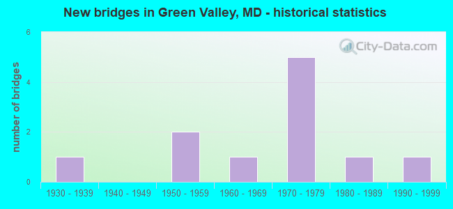
- New bridges - historical statistics
- 11930-1939
- 21950-1959
- 11960-1969
- 51970-1979
- 11980-1989
- 11990-1999


- Bridge Condition - Deck
- 66.7%Satisfactory
- 33.3%Fair

- Bridge Condition - Superstructure
- 83.3%Satisfactory
- 16.7%Fair

- Bridge Condition - Substructure
- 66.7%Satisfactory
- 33.3%Fair

- Bridge Condition - Channel
- 16.7%Very good
- 16.7%Good
- 50.0%Satisfactory
- 16.7%Fair

- Bridge Condition - Culverts
- 33.3%Very good
- 33.3%Good
- 33.3%Poor
Find on map >> Show street view
Structure Number: 10000010002104, Location: 0.84 MILE EAST OF MD 75 (Lat: 39.378367, Lng: -77.245186), Route carried "on" structure: Interstate 70, Year Built: 1954, Year Reconstructed: 1972, Status: Open, Structure Length: 1.10m (3.61ft), Average Daily Traffic: 69,020 (year 2009), Truck Traffic: 8%, Average Future Daily Traffic: 70,362 (year 2026), Design Load: HS 20, Features Intersected: BUSH CREEK
Minimum Vertical Clearance: 30+ m (98+ ft), Kilometerpoint: 39.903, Lanes on structure: 6, Base Highway Network: Yes, Owner: State Highway Agency, Approaching Roadway Width: 31.7m (104.0ft), Skew: 21 degrees, Material/Design: Concrete, Design/Construction: Frame, Number Of Spans In Main Unit: 1, Length of Maximum Span: 11.0m (36.1ft), Curb-To-Curb Width: 46.9m (153.9ft), Out-to-Out Width: 62.0m (203.4ft)
Condition: Deck: Satisfactory, Superstructure: Satisfactory, Substructure: Satisfactory, Channel: Good, Operating Rating: 51.2 metric tons, Method Used To Determine Operating Rating: Load Factor (LF), Inventory Rating: 30.4 metric tons, Method Used To Determine Inventory Rating: Load Factor (LF), Structural Evaluation: Equal to present minimum criteria, Deck Geometry: Superior to present desirable criteria, Waterway Adequacy: Equal to present desirable criteria, Approach Roadway Alignment: Equal to present desirable criteria, Length Of Structure Improvement: 1.22m (4.00ft), Designated Inspection Frequency: Every 24 months, Inspection Date: October 2021, Bridge Improvement Cost: $293,000, Roadway Improvement Cost: $29,000, Total Project Cost: $322,000, Deck Structure Type: Concrete Cast-file-Place, Wearing Surface/Protective System: Wearing Surface: Bituminous
Find on map >> Show street view
Structure Number: 100000100039013, Location: .09 M E OF BILL MOXLEY RD (Lat: 39.366944, Lng: -77.195444), Route carried "on" structure: Interstate 70, Year Built: 1954, Year Reconstructed: 1974, Status: Open, Structure Length: 7.35m (24.11ft), Average Daily Traffic: 67,891 (year 2017), Truck Traffic: 8%, Average Future Daily Traffic: 104,958 (year 2039), Design Load: HS 20, Features Intersected: CSX TRANS.
Minimum Vertical Clearance: 30+ m (98+ ft), Kilometerpoint: 44.610, Lanes on structure: 3, Base Highway Network: Yes, Owner: State Highway Agency, Approaching Roadway Width: 15.2m (49.9ft), Skew: 5 degrees, Material/Design: Steel, Design/Construction: Stringer/Multi-beam, Number Of Spans In Main Unit: 3, Length of Maximum Span: 28.7m (94.2ft), Curb-To-Curb Width: 15.7m (51.5ft), Out-to-Out Width: 16.7m (54.8ft)
Condition: Deck: Satisfactory, Superstructure: Satisfactory, Substructure: Satisfactory, Operating Rating: 84.8 metric tons, Method Used To Determine Operating Rating: Load Factor (LF), Inventory Rating: 50.8 metric tons, Method Used To Determine Inventory Rating: Load Factor (LF), Structural Evaluation: Equal to present minimum criteria, Deck Geometry: Somewhat better than minimum adequacy, Underclear: Equal to present minimum criteria, Approach Roadway Alignment: Equal to present desirable criteria, Designated Inspection Frequency: Every 24 months, Inspection Date: September 2020, Deck Structure Type: Concrete Cast-file-Place, Wearing Surface/Protective System: Wearing Surface: Monolithic Concrete
Find on map >> Show street view
Structure Number: 10000010004401, Location: .65 MILE SOUTH OF MD 75FB (Lat: 39.370344, Lng: -77.271847), Route carried "on" structure: State highway 75, Year Built: 1972, Status: Open, Structure Length: 2.62m (8.60ft), Average Daily Traffic: 6,492 (year 2009), Truck Traffic: 8%, Average Future Daily Traffic: 7,370 (year 2026), Design Load: HS 20, Features Intersected: BUSH CREEK
Minimum Vertical Clearance: 30+ m (98+ ft), Kilometerpoint: 10.764, Lanes on structure: 2, Owner: State Highway Agency, Approaching Roadway Width: 9.8m (32.2ft), Skew: 2 degrees, Material/Design: Steel continuous, Design/Construction: Stringer/Multi-beam, Number Of Spans In Main Unit: 2, Length of Maximum Span: 12.5m (41.0ft), Curb-To-Curb Width: 8.8m (28.9ft), Out-to-Out Width: 9.3m (30.5ft)
Condition: Deck: Satisfactory, Superstructure: Satisfactory, Substructure: Satisfactory, Channel: Satisfactory, Operating Rating: 56.2 metric tons, Method Used To Determine Operating Rating: Load Factor (LF), Inventory Rating: 33.6 metric tons, Method Used To Determine Inventory Rating: Load Factor (LF), Structural Evaluation: Equal to present minimum criteria, Deck Geometry: High priority of replacement, Waterway Adequacy: Equal to present desirable criteria, Approach Roadway Alignment: Equal to present minimum criteria, Length Of Structure Improvement: 2.62m (8.60ft), Designated Inspection Frequency: Every 24 months, Inspection Date: October 2021, Bridge Improvement Cost: $157,000, Roadway Improvement Cost: $16,000, Total Project Cost: $173,000, Deck Structure Type: Concrete Cast-file-Place, Wearing Surface/Protective System: Wearing Surface: Monolithic Concrete
Find on map >> Show street view
Structure Number: 10000010004601, Location: 1.71 MILES N OF MD 355 (Lat: 39.310144, Lng: -77.297967), Route carried "on" structure: State highway 75, Year Built: 1930, Status: Open, Structure Length: 1.37m (4.49ft), Average Daily Traffic: 7,952 (year 2009), Truck Traffic: 8%, Average Future Daily Traffic: 9,653 (year 2026), Features Intersected: PLEASANT BRANCH
Minimum Vertical Clearance: 30+ m (98+ ft), Kilometerpoint: 2.732, Lanes on structure: 2, Owner: State Highway Agency, Approaching Roadway Width: 8.5m (27.9ft), Material/Design: Concrete, Design/Construction: Slab, Number Of Spans In Main Unit: 2, Length of Maximum Span: 6.1m (20.0ft), Curb-To-Curb Width: 7.3m (24.0ft), Out-to-Out Width: 7.9m (25.9ft)
Condition: Deck: Fair, Superstructure: Fair, Substructure: Fair, Channel: Fair, Operating Rating: 37.2 metric tons, Method Used To Determine Operating Rating: Load Factor (LF), Inventory Rating: 21.8 metric tons, Method Used To Determine Inventory Rating: Load Factor (LF), Structural Evaluation: Somewhat better than minimum adequacy, Deck Geometry: High priority of replacement, Waterway Adequacy: Equal to present minimum criteria, Approach Roadway Alignment: Equal to present desirable criteria, Length Of Structure Improvement: 1.37m (4.49ft), Designated Inspection Frequency: Every 24 months, Inspection Date: July 2021, Bridge Improvement Cost: $70,000, Roadway Improvement Cost: $7,000, Total Project Cost: $77,000, Deck Structure Type: Concrete Cast-file-Place, Wearing Surface/Protective System: Wearing Surface: Monolithic Concrete
Find on map >> Show street view
Structure Number: 10000010015601, Location: 0.24 MI S OF MD 144FB (Lat: 39.381389, Lng: -77.260078), Route carried "on" structure: State highway 75, Year Built: 1973, Status: Open, Structure Length: 8.20m (26.90ft), Average Daily Traffic: 9,752 (year 2006), Truck Traffic: 8%, Average Future Daily Traffic: 11,244 (year 2026), Design Load: HS 20, Features Intersected: IS 70
Minimum Vertical Clearance: 30+ m (98+ ft), Kilometerpoint: 13.065, Lanes on structure: 4, Lanes under structure: 6, Owner: State Highway Agency, Approaching Roadway Width: 26.8m (87.9ft), Skew: 20 degrees, Material/Design: Steel continuous, Design/Construction: Stringer/Multi-beam, Number Of Spans In Main Unit: 2, Length of Maximum Span: 40.2m (131.9ft), Curb-To-Curb Width: 26.8m (87.9ft), Out-to-Out Width: 27.8m (91.2ft)
Condition: Deck: Fair, Superstructure: Satisfactory, Substructure: Fair, Operating Rating: 80.3 metric tons, Method Used To Determine Operating Rating: Load Factor (LF), Inventory Rating: 48.1 metric tons, Method Used To Determine Inventory Rating: Load Factor (LF), Structural Evaluation: Somewhat better than minimum adequacy, Deck Geometry: Superior to present desirable criteria, Underclear: Somewhat better than minimum adequacy, Approach Roadway Alignment: Equal to present desirable criteria, Designated Inspection Frequency: Every 24 months, Inspection Date: September 2021, Deck Structure Type: Concrete Cast-file-Place, Wearing Surface/Protective System: Wearing Surface: Monolithic Concrete
Find on map >> Show street view
Structure Number: 100000100161013, Location: 1.73 MI W OF CARROLL CO (Lat: 39.367242, Lng: -77.196636), Route carried "on" structure: Interstate 70, Year Built: 1974, Status: Open, Structure Length: 4.27m (14.01ft), Average Daily Traffic: 69,020 (year 2009), Truck Traffic: 8%, Average Future Daily Traffic: 35,181 (year 2026), Design Load: HS 20, Features Intersected: BILL MOXELY ROAD
Minimum Vertical Clearance: 30+ m (98+ ft), Kilometerpoint: 44.457, Lanes on structure: 3, Lanes under structure: 2, Base Highway Network: Yes, Owner: State Highway Agency, Approaching Roadway Width: 15.9m (52.2ft), Skew: 2 degrees, Material/Design: Steel, Design/Construction: Stringer/Multi-beam, Number Of Spans In Main Unit: 1, Length of Maximum Span: 40.8m (133.9ft), Curb-To-Curb Width: 15.7m (51.5ft), Out-to-Out Width: 16.7m (54.8ft)
Condition: Deck: Satisfactory, Superstructure: Satisfactory, Substructure: Satisfactory, Operating Rating: 79.8 metric tons, Method Used To Determine Operating Rating: Load Factor (LF), Inventory Rating: 48.1 metric tons, Method Used To Determine Inventory Rating: Load Factor (LF), Structural Evaluation: Equal to present minimum criteria, Deck Geometry: Somewhat better than minimum adequacy, Underclear: Superior to present desirable criteria, Approach Roadway Alignment: Equal to present desirable criteria, Designated Inspection Frequency: Every 24 months, Inspection Date: January 2021, Deck Structure Type: Concrete Cast-file-Place, Wearing Surface/Protective System: Wearing Surface: Monolithic Concrete
Structure Number: 200000F-072502, Location: AT MD RT. 75 INTERSECTION, Route carried "on" structure: County highway 1599, Year Built: 1992, Status: Open, Structure Length: 0.94m (3.08ft), Average Daily Traffic: 1,000 (year 2009), Truck Traffic: 5%, Average Future Daily Traffic: 1,200 (year 2032), Design Load: HS 20+Mod, Features Intersected: PLEASANT BRANCH, Facility Carried by Structure: KNOLLS PARKWAY
Minimum Vertical Clearance: 30+ m (98+ ft), Kilometerpoint: 0.000, Lanes on structure: 2, Owner: County Highway Agency, Approaching Roadway Width: 16.5m (54.1ft), Skew: 30 degrees, Material/Design: Concrete, Design/Construction: Culvert, Number Of Spans In Main Unit: 4, Length of Maximum Span: 2.1m (6.9ft), Curb or Sidewalk Widths: Left: 0.2m (0.7ft), Right: 0.2m (0.7ft)
Condition: Channel: Very good, Culverts: Good, Operating Rating: 75.3 metric tons, Method Used To Determine Operating Rating: Load Factor (LF), Inventory Rating: 44.9 metric tons, Method Used To Determine Inventory Rating: Load Factor (LF), Structural Evaluation: Better than present minimum criteria, Waterway Adequacy: Equal to present desirable criteria, Approach Roadway Alignment: Equal to present desirable criteria, Designated Inspection Frequency: Every 24 months, Inspection Date: May 2021
Find on map >> Show street view
Structure Number: 200000F-090803, Location: 0.37 MI EAST OF MD 75 (Lat: 39.358653, Lng: -77.263436), Route carried "on" structure: County highway 395, Year Built: 1982, Status: Open, Structure Length: 0.82m (2.69ft), Average Daily Traffic: 859 (year 2009), Truck Traffic: 5%, Average Future Daily Traffic: 1,031 (year 2032), Features Intersected: CHURCH BRANCH, Facility Carried by Structure: WELLER ROAD
Minimum Vertical Clearance: 30+ m (98+ ft), Kilometerpoint: 0.563, Lanes on structure: 2, Owner: County Highway Agency, Approaching Roadway Width: 4.6m (15.1ft), Material/Design: Steel, Design/Construction: Culvert, Length of Maximum Span: 0.0m
Condition: Channel: Satisfactory, Culverts: Very good, Inventory Rating: 81.6 metric tons, Method Used To Determine Inventory Rating: Load Factor (LF), Structural Evaluation: Equal to present desirable criteria, Waterway Adequacy: Equal to present minimum criteria, Approach Roadway Alignment: Equal to present minimum criteria, Designated Inspection Frequency: Every 24 months, Inspection Date: May 2021
Find on map >> Show street view
Structure Number: 200000F-092003, Location: 0.1 MI N OF WELLER ROAD (Lat: 39.354642, Lng: -77.249256), Route carried "on" structure: County highway 396, Year Built: 1965, Status: Open, Structure Length: 1.16m (3.81ft), Average Daily Traffic: 2,175 (year 2020), Truck Traffic: 5%, Average Future Daily Traffic: 2,535 (year 2040), Features Intersected: CHURCH BRANCH, Facility Carried by Structure: LYNN BURKE ROAD
Minimum Vertical Clearance: 30+ m (98+ ft), Kilometerpoint: 2.751, Lanes on structure: 2, Owner: County Highway Agency, Approaching Roadway Width: 7.0m (23.0ft), Skew: 3 degrees, Material/Design: Steel, Design/Construction: Culvert, Length of Maximum Span: 0.0m
Condition: Channel: Satisfactory, Culverts: Poor, Structural Evaluation: Meets minimum limits, Waterway Adequacy: Equal to present minimum criteria, Approach Roadway Alignment: Equal to present desirable criteria, Length Of Structure Improvement: 1.16m (3.81ft), Designated Inspection Frequency: Every 24 months, Inspection Date: August 2020
Find on map >> Show street view
Structure Number: 10000010015601, Location: 0.07 M E OF BR NO 1017500 (Lat: 39.381403, Lng: -77.260147), Route carried "under" structure: Interstate 70, Year Built: 1973, Structure Length: 0. m, Average Daily Traffic: 69,020 (year 2009), Features Intersected: IS 70, Facility Carried by Structure: MD 75
Minimum Vertical Clearance: 4.88m (16.01ft), Kilometerpoint: 38.552, Lanes on structure: 4, Lanes under structure: 6, Material/Design: Steel continuous, Design/Construction: Stringer/Multi-beam, Length of Maximum Span: 40.2m (131.9ft)
Find on map >> Show street view
Structure Number: 100000100161013, Location: 1.75 MI W OF CARROLL CO (Lat: 39.367242, Lng: -77.196636), Route carried "under" structure: County highway 401, Year Built: 1974, Structure Length: 0. m, Features Intersected: BILL MOXELY ROAD, Facility Carried by Structure: IS 70 EBR
Minimum Vertical Clearance: 5.49m (18.01ft), Kilometerpoint: 4.296, Lanes on structure: 3, Lanes under structure: 2, Material/Design: Steel, Design/Construction: Stringer/Multi-beam, Length of Maximum Span: 40.8m (133.9ft)