Bridge Statistics for Greater Upper Marlboro, Maryland (MD)
Condition, Traffic, Stress, Structural Evaluation, Project Costs
- National Bridge Inventory (NBI) Statistics
- 25Number of bridges
- 200ft / 61.1mTotal length
- $5,180,000Total costs
- 747,252Total average daily traffic
- 44,477Total average daily truck traffic
- National Bridge Inventory (NBI) Registered Bridges for Greater Upper Marlboro
- No street view available for this location
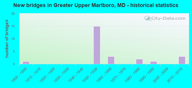
- New bridges - historical statistics
- 11900-1909
- 151950-1959
- 31960-1969
- 21980-1989
- 11990-1999
- 32010-2019

- Reconstructed bridges - Historical Statistics
- 11960-1969
- 01970-1979
- 31980-1989
- 11990-1999
- 12000-2009


- Bridge Condition - Deck
- 6.7%Very good
- 46.7%Good
- 20.0%Satisfactory
- 20.0%Fair
- 6.7%Poor

- Bridge Condition - Superstructure
- 13.3%Very good
- 20.0%Good
- 40.0%Satisfactory
- 26.7%Fair

- Bridge Condition - Substructure
- 13.3%Very good
- 20.0%Good
- 40.0%Satisfactory
- 26.7%Fair

- Bridge Condition - Channel
- 42.9%Very good
- 42.9%Good
- 14.3%Fair

- Bridge Condition - Culverts
- 33.3%Good
- 66.7%Satisfactory
Find on map >> Show street view
Structure Number: 10000016000901, Location: 0.62 MILE WEST OF MD 717 (Lat: 38.819450, Lng: -76.760789), Route carried "on" structure: State highway 725, Year Built: 2011, Status: Open, Structure Length: 1.17m (3.84ft), Average Daily Traffic: 13,032 (year 2010), Truck Traffic: 9%, Average Future Daily Traffic: 15,382 (year 2026), Design Load: HS 25 or greater, Features Intersected: FEDERAL SPRING BRANCH
Minimum Vertical Clearance: 30+ m (98+ ft), Kilometerpoint: 0.257, Lanes on structure: 2, Owner: State Highway Agency, Approaching Roadway Width: 9.8m (32.2ft), Skew: 2 degrees, Material/Design: Prestressed concrete, Design/Construction: Slab, Number Of Spans In Main Unit: 1, Length of Maximum Span: 9.8m (32.2ft), Curb or Sidewalk Widths: Left: 1.7m (5.6ft), Right: 0.0m, Curb-To-Curb Width: 9.9m (32.5ft), Out-to-Out Width: 12.8m (42.0ft)
Condition: Deck: Very good, Superstructure: Very good, Substructure: Very good, Channel: Very good, Operating Rating: 56.7 metric tons, Method Used To Determine Operating Rating: Load Factor (LF), Inventory Rating: 34.0 metric tons, Method Used To Determine Inventory Rating: Load Factor (LF), Structural Evaluation: Equal to present desirable criteria, Deck Geometry: Meets minimum limits, Waterway Adequacy: Equal to present desirable criteria, Approach Roadway Alignment: Equal to present desirable criteria, Length Of Structure Improvement: 1.16m (3.81ft), Designated Inspection Frequency: Every 24 months, Inspection Date: April 2020, Bridge Improvement Cost: $691,000, Roadway Improvement Cost: $312,000, Total Project Cost: $1,622,000, Deck Structure Type: Concrete Cast-file-Place, Wearing Surface/Protective System: Wearing Surface: Monolithic Concrete
Find on map >> Show street view
Structure Number: 10000016003102, Location: 0.79 MILE NORTH OF MD 193 (Lat: 38.875508, Lng: -76.798486), Route carried "on" structure: State highway 202, Year Built: 1959, Status: Open, Structure Length: 2.26m (7.41ft), Average Daily Traffic: 26,592 (year 2009), Truck Traffic: 8%, Average Future Daily Traffic: 27,916 (year 2026), Design Load: HS 20, Features Intersected: WESTERN BRANCH
Minimum Vertical Clearance: 30+ m (98+ ft), Kilometerpoint: 8.270, Lanes on structure: 2, Base Highway Network: Yes, Owner: State Highway Agency, Approaching Roadway Width: 14.6m (47.9ft), Material/Design: Concrete, Design/Construction: Culvert, Length of Maximum Span: 6.1m (20.0ft)
Condition: Channel: Good, Culverts: Satisfactory, Operating Rating: 63.9 metric tons, Method Used To Determine Operating Rating: Load Factor (LF), Inventory Rating: 38.1 metric tons, Method Used To Determine Inventory Rating: Load Factor (LF), Structural Evaluation: Equal to present minimum criteria, Waterway Adequacy: Equal to present minimum criteria, Approach Roadway Alignment: Equal to present desirable criteria, Designated Inspection Frequency: Every 24 months, Inspection Date: October 2020
Find on map >> Show street view
Structure Number: 10000016003201, Location: 0.03 MILE NORTH OF MD 725 (Lat: 38.820611, Lng: -76.745561), Route carried "on" structure: State highway 202, Year Built: 1992, Status: Open, Structure Length: 2.13m (6.99ft), Average Daily Traffic: 17,642 (year 2009), Truck Traffic: 7%, Average Future Daily Traffic: 19,234 (year 2026), Design Load: HS 25 or greater, Features Intersected: COLLINGTON BRANCH
Minimum Vertical Clearance: 30+ m (98+ ft), Kilometerpoint: 0.048, Lanes on structure: 5, Base Highway Network: Yes, Owner: State Highway Agency, Approaching Roadway Width: 18.0m (59.1ft), Material/Design: Steel, Design/Construction: Stringer/Multi-beam, Number Of Spans In Main Unit: 1, Length of Maximum Span: 21.3m (69.9ft), Curb or Sidewalk Widths: Left: 1.6m (5.2ft), Right: 1.6m (5.2ft), Curb-To-Curb Width: 17.4m (57.1ft), Out-to-Out Width: 21.3m (69.9ft)
Condition: Deck: Good, Superstructure: Good, Substructure: Good, Channel: Very good, Inventory Rating: 75.7 metric tons, Method Used To Determine Inventory Rating: Load Factor (LF), Structural Evaluation: Better than present minimum criteria, Deck Geometry: High priority of replacement, Waterway Adequacy: Better than present minimum criteria, Approach Roadway Alignment: Equal to present minimum criteria, Length Of Structure Improvement: 2.13m (6.99ft), Designated Inspection Frequency: Every 24 months, Inspection Date: May 2021, Bridge Improvement Cost: $293,000, Roadway Improvement Cost: $29,000, Total Project Cost: $322,000, Deck Structure Type: Concrete Cast-file-Place, Wearing Surface/Protective System: Wearing Surface: Monolithic Concrete, Deck Protection: Epoxy Coated Reinforcing
Find on map >> Show street view
Structure Number: 10000016004502, Location: 0.44 MILE EAST OF MD 978C (Lat: 38.900678, Lng: -76.734831), Route carried "on" structure: State highway 214, Year Built: 1958, Status: Open, Structure Length: 4.69m (15.39ft), Average Daily Traffic: 22,881 (year 2012), Truck Traffic: 8%, Average Future Daily Traffic: 30,889 (year 2032), Design Load: HS 20, Features Intersected: COLLINGTON BRANCH
Minimum Vertical Clearance: 30+ m (98+ ft), Kilometerpoint: 15.989, Lanes on structure: 4, Base Highway Network: Yes, Owner: State Highway Agency, Approaching Roadway Width: 39.6m (129.9ft), Skew: 1 degrees, Material/Design: Concrete, Design/Construction: Culvert, Length of Maximum Span: 4.9m (16.1ft)
Condition: Channel: Good, Culverts: Good, Operating Rating: 32.7 metric tons, Method Used To Determine Operating Rating: Field evaluation and documented engineering judgment, Inventory Rating: 32.7 metric tons, Method Used To Determine Inventory Rating: Field evaluation and documented engineering judgment, Structural Evaluation: Better than present minimum criteria, Waterway Adequacy: Better than present minimum criteria, Approach Roadway Alignment: Equal to present minimum criteria, Designated Inspection Frequency: Every 24 months, Inspection Date: Febuary 2022
Find on map >> Show street view
Structure Number: 10000016009601, Location: 0.20 MILE SOUTH OF MD 4PA (Lat: 38.812297, Lng: -76.721681), Route carried "on" structure: State highway 726, Year Built: 1959, Year Reconstructed: 1986, Status: Open, Structure Length: 6.74m (22.11ft), Average Daily Traffic: 2,599 (year 2006), Truck Traffic: 8%, Average Future Daily Traffic: 2,997 (year 2026), Design Load: HS 20, Features Intersected: MD 4
Minimum Vertical Clearance: 30+ m (98+ ft), Kilometerpoint: 0.129, Lanes on structure: 2, Lanes under structure: 4, Toll: On toll road, Owner: State Highway Agency, Approaching Roadway Width: 7.9m (25.9ft), Material/Design: Steel, Design/Construction: Stringer/Multi-beam, Number Of Spans In Main Unit: 4, Length of Maximum Span: 23.5m (77.1ft), Curb-To-Curb Width: 7.9m (25.9ft), Out-to-Out Width: 9.5m (31.2ft)
Condition: Deck: Good, Superstructure: Good, Substructure: Good, Operating Rating: 85.3 metric tons, Method Used To Determine Operating Rating: Load Factor (LF), Inventory Rating: 51.2 metric tons, Method Used To Determine Inventory Rating: Load Factor (LF), Structural Evaluation: Better than present minimum criteria, Deck Geometry: High priority of corrective action, Underclear: Equal to present minimum criteria, Approach Roadway Alignment: Equal to present desirable criteria, Length Of Structure Improvement: 6.74m (22.11ft), Designated Inspection Frequency: Every 24 months, Inspection Date: September 2020, Bridge Improvement Cost: $414,000, Roadway Improvement Cost: $41,000, Total Project Cost: $455,000, Deck Structure Type: Concrete Cast-file-Place, Wearing Surface/Protective System: Wearing Surface: Monolithic Concrete, Deck Protection: Epoxy Coated Reinforcing
Find on map >> Show street view
Structure Number: 100000160097013, Location: 0.65 MILE SOUTH OF MD 717 (Lat: 38.814172, Lng: -76.737819), Route carried "on" structure: State highway 4, Year Built: 1959, Year Reconstructed: 1986, Status: Open, Structure Length: 6.34m (20.80ft), Average Daily Traffic: 23,836 (year 2006), Truck Traffic: 8%, Average Future Daily Traffic: 27,483 (year 2026), Design Load: HS 20, Features Intersected: US 301
Minimum Vertical Clearance: 30+ m (98+ ft), Kilometerpoint: 2.264, Lanes on structure: 3, Lanes under structure: 6, Base Highway Network: Yes, Owner: State Highway Agency, Approaching Roadway Width: 13.7m (44.9ft), Skew: 1 degrees, Material/Design: Steel, Design/Construction: Stringer/Multi-beam, Number Of Spans In Main Unit: 4, Length of Maximum Span: 21.0m (68.9ft), Curb-To-Curb Width: 13.7m (44.9ft), Out-to-Out Width: 14.7m (48.2ft)
Condition: Deck: Good, Superstructure: Satisfactory, Substructure: Satisfactory, Operating Rating: 84.8 metric tons, Method Used To Determine Operating Rating: Load Factor (LF), Inventory Rating: 50.8 metric tons, Method Used To Determine Inventory Rating: Load Factor (LF), Structural Evaluation: Equal to present minimum criteria, Deck Geometry: Meets minimum limits, Underclear: Meets minimum limits, Approach Roadway Alignment: Equal to present desirable criteria, Length Of Structure Improvement: 6.34m (20.80ft), Designated Inspection Frequency: Every 24 months, Inspection Date: July 2020, Bridge Improvement Cost: $602,000, Roadway Improvement Cost: $60,000, Total Project Cost: $662,000, Deck Structure Type: Concrete Cast-file-Place, Wearing Surface/Protective System: Wearing Surface: Monolithic Concrete, Deck Protection: Epoxy Coated Reinforcing
Find on map >> Show street view
Structure Number: 100000160097014, Location: 0.65 MILE SOUTH OF MD 717 (Lat: 38.813811, Lng: -76.738642), Route carried "on" structure: State highway 4, Year Built: 1959, Year Reconstructed: 1986, Status: Open, Structure Length: 6.40m (21.00ft), Average Daily Traffic: 23,836 (year 2006), Truck Traffic: 8%, Average Future Daily Traffic: 27,483 (year 2026), Design Load: HS 20, Features Intersected: US 301
Minimum Vertical Clearance: 30+ m (98+ ft), Kilometerpoint: 2.264, Lanes on structure: 3, Lanes under structure: 6, Base Highway Network: Yes, Owner: State Highway Agency, Approaching Roadway Width: 13.7m (44.9ft), Skew: 1 degrees, Material/Design: Steel, Design/Construction: Stringer/Multi-beam, Number Of Spans In Main Unit: 4, Length of Maximum Span: 21.0m (68.9ft), Curb-To-Curb Width: 13.7m (44.9ft), Out-to-Out Width: 14.7m (48.2ft)
Condition: Deck: Good, Superstructure: Satisfactory, Substructure: Satisfactory, Operating Rating: 84.8 metric tons, Method Used To Determine Operating Rating: Load Factor (LF), Inventory Rating: 50.8 metric tons, Method Used To Determine Inventory Rating: Load Factor (LF), Structural Evaluation: Equal to present minimum criteria, Deck Geometry: Meets minimum limits, Underclear: Meets minimum limits, Approach Roadway Alignment: Equal to present desirable criteria, Length Of Structure Improvement: 6.40m (21.00ft), Designated Inspection Frequency: Every 24 months, Inspection Date: July 2020, Bridge Improvement Cost: $607,000, Roadway Improvement Cost: $61,000, Total Project Cost: $668,000, Deck Structure Type: Concrete Cast-file-Place, Wearing Surface/Protective System: Wearing Surface: Monolithic Concrete, Deck Protection: Epoxy Coated Reinforcing
Find on map >> Show street view
Structure Number: 100000160098043, Location: 0.21 MILE NORTH OF US 301 (Lat: 38.813953, Lng: -76.741978), Route carried "on" structure: State highway 4, Year Built: 1959, Status: Open, Structure Length: 1.10m (3.61ft), Average Daily Traffic: 46,652 (year 2009), Truck Traffic: 8%, Average Future Daily Traffic: 61,372 (year 2029), Design Load: HS 20, Features Intersected: CSX TRANSPORTATION
Minimum Vertical Clearance: 30+ m (98+ ft), Kilometerpoint: 2.599, Lanes on structure: 3, Base Highway Network: Yes, Owner: State Highway Agency, Approaching Roadway Width: 13.7m (44.9ft), Skew: 1 degrees, Material/Design: Concrete, Design/Construction: Frame, Number Of Spans In Main Unit: 1, Length of Maximum Span: 9.4m (30.8ft), Curb-To-Curb Width: 13.1m (43.0ft), Out-to-Out Width: 14.7m (48.2ft)
Condition: Deck: Fair, Superstructure: Fair, Substructure: Fair, Operating Rating: 45.4 metric tons, Method Used To Determine Operating Rating: Field evaluation and documented engineering judgment, Inventory Rating: 32.7 metric tons, Method Used To Determine Inventory Rating: Field evaluation and documented engineering judgment, Structural Evaluation: Somewhat better than minimum adequacy, Deck Geometry: High priority of replacement, Underclear: Somewhat better than minimum adequacy, Approach Roadway Alignment: Equal to present desirable criteria, Designated Inspection Frequency: Every 24 months, Inspection Date: June 2020, Deck Structure Type: Concrete Cast-file-Place, Wearing Surface/Protective System: Wearing Surface: Bituminous
Find on map >> Show street view
Structure Number: 100000160098044, Location: 0.21 MILE NORTH OF US 301 (Lat: 38.813664, Lng: -76.742211), Route carried "on" structure: State highway 4, Year Built: 1959, Status: Open, Structure Length: 1.10m (3.61ft), Average Daily Traffic: 46,652 (year 2009), Truck Traffic: 8%, Average Future Daily Traffic: 61,372 (year 2029), Design Load: HS 20, Features Intersected: CSX TRANSPORTATION
Minimum Vertical Clearance: 30+ m (98+ ft), Kilometerpoint: 2.599, Lanes on structure: 2, Base Highway Network: Yes, Owner: State Highway Agency, Approaching Roadway Width: 13.7m (44.9ft), Skew: 1 degrees, Material/Design: Concrete, Design/Construction: Frame, Number Of Spans In Main Unit: 1, Length of Maximum Span: 9.4m (30.8ft), Curb-To-Curb Width: 13.1m (43.0ft), Out-to-Out Width: 14.7m (48.2ft)
Condition: Deck: Satisfactory, Superstructure: Satisfactory, Substructure: Satisfactory, Operating Rating: 45.4 metric tons, Method Used To Determine Operating Rating: Field evaluation and documented engineering judgment, Inventory Rating: 32.7 metric tons, Method Used To Determine Inventory Rating: Field evaluation and documented engineering judgment, Structural Evaluation: Equal to present minimum criteria, Deck Geometry: Superior to present desirable criteria, Underclear: Somewhat better than minimum adequacy, Approach Roadway Alignment: Equal to present desirable criteria, Designated Inspection Frequency: Every 24 months, Inspection Date: June 2020, Deck Structure Type: Concrete Cast-file-Place, Wearing Surface/Protective System: Wearing Surface: Bituminous
Find on map >> Show street view
Structure Number: 100000160099013, Location: 0.65 MILE NORTH OF US 301 (Lat: 38.812864, Lng: -76.749700), Route carried "on" structure: State highway 4, Year Built: 1959, Status: Open, Structure Length: 2.80m (9.19ft), Average Daily Traffic: 46,652 (year 2009), Truck Traffic: 8%, Average Future Daily Traffic: 61,372 (year 2029), Design Load: HS 20, Features Intersected: MD 717
Minimum Vertical Clearance: 30+ m (98+ ft), Kilometerpoint: 3.334, Lanes on structure: 2, Lanes under structure: 2, Base Highway Network: Yes, Owner: State Highway Agency, Approaching Roadway Width: 12.5m (41.0ft), Material/Design: Steel, Design/Construction: Stringer/Multi-beam, Number Of Spans In Main Unit: 3, Length of Maximum Span: 13.1m (43.0ft), Curb-To-Curb Width: 12.2m (40.0ft), Out-to-Out Width: 13.8m (45.3ft)
Condition: Deck: Fair, Superstructure: Satisfactory, Substructure: Satisfactory, Operating Rating: 74.4 metric tons, Method Used To Determine Operating Rating: Load Factor (LF), Inventory Rating: 44.4 metric tons, Method Used To Determine Inventory Rating: Load Factor (LF), Structural Evaluation: Equal to present minimum criteria, Deck Geometry: Better than present minimum criteria, Underclear: High priority of corrective action, Approach Roadway Alignment: Equal to present desirable criteria, Designated Inspection Frequency: Every 24 months, Inspection Date: March 2020, Deck Structure Type: Concrete Cast-file-Place, Wearing Surface/Protective System: Wearing Surface: Bituminous
Find on map >> Show street view
Structure Number: 100000160099014, Location: 0.65 MILE NORTH OF US 301 (Lat: 38.812489, Lng: -76.749881), Route carried "on" structure: State highway 4, Year Built: 1959, Status: Open, Structure Length: 2.80m (9.19ft), Average Daily Traffic: 46,652 (year 2009), Truck Traffic: 8%, Average Future Daily Traffic: 61,372 (year 2029), Design Load: HS 20, Features Intersected: MD 717
Minimum Vertical Clearance: 30+ m (98+ ft), Kilometerpoint: 3.334, Lanes on structure: 2, Lanes under structure: 2, Base Highway Network: Yes, Owner: State Highway Agency, Approaching Roadway Width: 12.5m (41.0ft), Material/Design: Steel, Design/Construction: Stringer/Multi-beam, Number Of Spans In Main Unit: 3, Length of Maximum Span: 13.1m (43.0ft), Curb-To-Curb Width: 12.2m (40.0ft), Out-to-Out Width: 13.8m (45.3ft)
Condition: Deck: Poor, Superstructure: Satisfactory, Substructure: Satisfactory, Operating Rating: 74.4 metric tons, Method Used To Determine Operating Rating: Load Factor (LF), Inventory Rating: 44.4 metric tons, Method Used To Determine Inventory Rating: Load Factor (LF), Structural Evaluation: Equal to present minimum criteria, Deck Geometry: Better than present minimum criteria, Underclear: High priority of corrective action, Approach Roadway Alignment: Equal to present desirable criteria, Designated Inspection Frequency: Every 24 months, Inspection Date: March 2020, Deck Structure Type: Concrete Cast-file-Place, Wearing Surface/Protective System: Wearing Surface: Bituminous
Find on map >> Show street view
Structure Number: 10000016010101, Location: OLD CRAIN HWY @ MD 4 (Lat: 38.810103, Lng: -76.764606), Route carried "on" structure: County highway 1212, Year Built: 1988, Status: Open, Structure Length: 7.16m (23.49ft), Average Daily Traffic: 6,871 (year 2012), Truck Traffic: 5%, Average Future Daily Traffic: 9,276 (year 2012), Design Load: HS 20, Features Intersected: MD 4, Facility Carried by Structure: OLD CRAIN HWY
Minimum Vertical Clearance: 30+ m (98+ ft), Kilometerpoint: 2.703, Lanes on structure: 2, Lanes under structure: 4, Base Highway Network: Yes, Owner: State Highway Agency, Approaching Roadway Width: 9.1m (29.9ft), Skew: 2 degrees, Material/Design: Steel continuous, Design/Construction: Stringer/Multi-beam, Number Of Spans In Main Unit: 2, Length of Maximum Span: 35.1m (115.2ft), Curb or Sidewalk Widths: Left: 0.0m, Right: 1.5m (4.9ft), Curb-To-Curb Width: 9.1m (29.9ft), Out-to-Out Width: 11.5m (37.7ft)
Condition: Deck: Good, Superstructure: Satisfactory, Substructure: Good, Inventory Rating: 61.7 metric tons, Method Used To Determine Inventory Rating: Load Factor (LF), Structural Evaluation: Equal to present minimum criteria, Deck Geometry: Meets minimum limits, Underclear: Equal to present minimum criteria, Approach Roadway Alignment: Equal to present desirable criteria, Designated Inspection Frequency: Every 24 months, Inspection Date: April 2020, Deck Structure Type: Concrete Cast-file-Place, Wearing Surface/Protective System: Wearing Surface: Monolithic Concrete, Deck Protection: Epoxy Coated Reinforcing
Find on map >> Show street view
Structure Number: 100000160108013, Location: 0.37 MILE SOUTH OF MD 717 (Lat: 38.813889, Lng: -76.743197), Route carried "on" structure: State highway 4, Year Built: 1960, Status: Open, Structure Length: 2.41m (7.91ft), Average Daily Traffic: 46,652 (year 2009), Truck Traffic: 8%, Average Future Daily Traffic: 61,372 (year 2029), Design Load: HS 20, Features Intersected: RACE TRACK RD
Minimum Vertical Clearance: 30+ m (98+ ft), Kilometerpoint: 2.737, Lanes on structure: 3, Lanes under structure: 2, Base Highway Network: Yes, Owner: State Highway Agency, Approaching Roadway Width: 12.5m (41.0ft), Material/Design: Prestressed concrete, Design/Construction: Slab, Number Of Spans In Main Unit: 3, Length of Maximum Span: 7.9m (25.9ft), Curb-To-Curb Width: 12.2m (40.0ft), Out-to-Out Width: 13.9m (45.6ft)
Condition: Deck: Satisfactory, Superstructure: Fair, Substructure: Fair, Operating Rating: 40.0 metric tons, Method Used To Determine Operating Rating: Load Factor (LF), Inventory Rating: 24.0 metric tons, Method Used To Determine Inventory Rating: Load Factor (LF), Structural Evaluation: Somewhat better than minimum adequacy, Deck Geometry: High priority of replacement, Underclear: High priority of replacement, Approach Roadway Alignment: Equal to present desirable criteria, Length Of Structure Improvement: 2.41m (7.91ft), Designated Inspection Frequency: Every 24 months, Inspection Date: January 2021, Bridge Improvement Cost: $431,000, Roadway Improvement Cost: $43,000, Total Project Cost: $474,000, Deck Structure Type: Concrete Cast-file-Place, Wearing Surface/Protective System: Wearing Surface: Latex Concrete
Find on map >> Show street view
Structure Number: 100000160108014, Location: 0.37 MILE SOUTH OF MD 717 (Lat: 38.813603, Lng: -76.743442), Route carried "on" structure: State highway 4, Year Built: 1960, Status: Open, Structure Length: 2.41m (7.91ft), Average Daily Traffic: 46,652 (year 2009), Truck Traffic: 8%, Average Future Daily Traffic: 61,372 (year 2029), Design Load: HS 20, Features Intersected: RACE TRACK RD
Minimum Vertical Clearance: 30+ m (98+ ft), Kilometerpoint: 2.737, Lanes on structure: 3, Lanes under structure: 2, Base Highway Network: Yes, Owner: State Highway Agency, Approaching Roadway Width: 12.5m (41.0ft), Material/Design: Prestressed concrete, Design/Construction: Slab, Number Of Spans In Main Unit: 3, Length of Maximum Span: 7.9m (25.9ft), Curb-To-Curb Width: 13.1m (43.0ft), Out-to-Out Width: 14.8m (48.6ft)
Condition: Deck: Fair, Superstructure: Fair, Substructure: Fair, Operating Rating: 56.7 metric tons, Method Used To Determine Operating Rating: Load Factor (LF), Inventory Rating: 34.0 metric tons, Method Used To Determine Inventory Rating: Load Factor (LF), Structural Evaluation: Somewhat better than minimum adequacy, Deck Geometry: High priority of replacement, Underclear: High priority of replacement, Approach Roadway Alignment: Equal to present desirable criteria, Length Of Structure Improvement: 2.41m (7.91ft), Designated Inspection Frequency: Every 24 months, Inspection Date: January 2021, Bridge Improvement Cost: $460,000, Roadway Improvement Cost: $46,000, Total Project Cost: $506,000, Deck Structure Type: Concrete Cast-file-Place, Wearing Surface/Protective System: Wearing Surface: Latex Concrete
Find on map >> Show street view
Structure Number: 10000016010901, Location: 0.13 MILE NORTH OF MD 4 (Lat: 38.814256, Lng: -76.750683), Route carried "on" structure: State highway 717, Year Built: 1900, Year Reconstructed: 1966, Status: Posted for load, Structure Length: 1.31m (4.30ft), Average Daily Traffic: 11,061 (year 2009), Truck Traffic: 8%, Average Future Daily Traffic: 12,984 (year 2026), Design Load: H 15, Features Intersected: WESTERN BRANCH
Minimum Vertical Clearance: 30+ m (98+ ft), Kilometerpoint: 0.290, Lanes on structure: 2, Owner: State Highway Agency, Approaching Roadway Width: 5.5m (18.0ft), Material/Design: Steel, Design/Construction: Girder and Floorbeam System, Number Of Spans In Main Unit: 1, Length of Maximum Span: 12.2m (40.0ft), Curb-To-Curb Width: 6.7m (22.0ft), Out-to-Out Width: 6.9m (22.6ft)
Condition: Deck: Satisfactory, Superstructure: Fair, Substructure: Fair, Channel: Very good, Operating Rating: 26.8 metric tons, Method Used To Determine Operating Rating: Load Factor (LF), Inventory Rating: 15.9 metric tons, Method Used To Determine Inventory Rating: Load Factor (LF), Structural Evaluation: High priority of replacement, Deck Geometry: High priority of replacement, Waterway Adequacy: Somewhat better than minimum adequacy, Approach Roadway Alignment: Equal to present desirable criteria, Bridge Posting: Required (Relationship of Operating Rating to Maximum Legal Load: 0.1 - 9.9% below), Length Of Structure Improvement: 1.31m (4.30ft), Designated Inspection Frequency: Every 12 months, Critical Feature Inspection Frequency: Every 12 months, Inspection Date: April 2021, Critical Feature Inspection Date: April 2021, Bridge Improvement Cost: $116,000, Roadway Improvement Cost: $12,000, Total Project Cost: $128,000, Deck Structure Type: Open Grating, Wearing Surface/Protective System: Wearing Surface: Other
Find on map >> Show street view
Structure Number: 100000160181011, Location: 1.37 MILES S OF MD 4PB (Lat: 38.813986, Lng: -76.824625), Route carried "on" structure: State highway 4, Year Built: 2014, Status: Open, Structure Length: 6.40m (21.00ft), Average Daily Traffic: 63,050 (year 2011), Truck Traffic: 9%, Average Future Daily Traffic: 90,900 (year 2031), Features Intersected: MD 223
Minimum Vertical Clearance: 30+ m (98+ ft), Kilometerpoint: 10.121, Lanes on structure: 3, Lanes under structure: 5, Base Highway Network: Yes, Owner: State Highway Agency, Approaching Roadway Width: 10.4m (34.1ft), Skew: 2 degrees, Material/Design: Steel continuous, Design/Construction: Stringer/Multi-beam, Number Of Spans In Main Unit: 2, Length of Maximum Span: 32.0m (105.0ft), Curb-To-Curb Width: 19.5m (64.0ft), Out-to-Out Width: 20.7m (67.9ft)
Condition: Deck: Good, Superstructure: Very good, Substructure: Very good, Operating Rating: 58.3 metric tons, Method Used To Determine Operating Rating: Load and Resistance Factor Rating (LRFR) rating reported by rating factor(RF) method using HL-93 loadings, Inventory Rating: 45.4 metric tons, Method Used To Determine Inventory Rating: Load and Resistance Factor Rating (LRFR) rating reported by rating factor(RF) method using HL-93 loadings, Structural Evaluation: Equal to present desirable criteria, Deck Geometry: Superior to present desirable criteria, Underclear: Meets minimum limits, Approach Roadway Alignment: Equal to present desirable criteria, Designated Inspection Frequency: Every 24 months, Inspection Date: November 2020, Deck Structure Type: Concrete Cast-file-Place, Wearing Surface/Protective System: Wearing Surface: Integral Concrete, Deck Protection: Epoxy Coated Reinforcing
Find on map >> Show street view
Structure Number: 200000P-050302, Location: 1.1 MI SOUTH OF US 301 (Lat: 38.782486, Lng: -76.762264), Route carried "on" structure: County highway 108, Year Built: 1950, Year Reconstructed: 2002, Status: Posted for load, Structure Length: 1.16m (3.81ft), Average Daily Traffic: 5,544 (year 2019), Truck Traffic: 10%, Average Future Daily Traffic: 8,240 (year 2039), Design Load: H 20, Features Intersected: CHARLES BRANCH, Facility Carried by Structure: CROOM STATION ROAD
Minimum Vertical Clearance: 30+ m (98+ ft), Kilometerpoint: 3.282, Lanes on structure: 2, Owner: County Highway Agency, Approaching Roadway Width: 9.8m (32.2ft), Skew: 3 degrees, Material/Design: Concrete, Design/Construction: Culvert, Length of Maximum Span: 5.5m (18.0ft), Curb-To-Curb Width: 6.7m (22.0ft), Out-to-Out Width: 7.3m (24.0ft)
Condition: Channel: Fair, Culverts: Satisfactory, Operating Rating: 67.6 metric tons, Method Used To Determine Operating Rating: Load Factor (LF), Inventory Rating: 40.4 metric tons, Method Used To Determine Inventory Rating: Load Factor (LF), Structural Evaluation: Equal to present minimum criteria, Deck Geometry: High priority of replacement, Waterway Adequacy: Better than present minimum criteria, Approach Roadway Alignment: Equal to present minimum criteria, Length Of Structure Improvement: 1.16m (3.81ft), Designated Inspection Frequency: Every 24 months, Inspection Date: Febuary 2021, Bridge Improvement Cost: $312,000, Roadway Improvement Cost: $31,000, Total Project Cost: $343,000
Find on map >> Show street view
Structure Number: 200000P-059701, Location: 0.04 MI S OF MD 202 (Lat: 38.875453, Lng: -76.803061), Route carried "on" structure: County highway 97, Year Built: 1967, Year Reconstructed: 2005, Status: Open, Structure Length: 2.68m (8.79ft), Average Daily Traffic: 13,443 (year 2014), Truck Traffic: 20%, Average Future Daily Traffic: 19,976 (year 2034), Design Load: HS 25 or greater, Features Intersected: SOUTHWEST BRANCH, Facility Carried by Structure: WHITE HOUSE ROAD
Minimum Vertical Clearance: 30+ m (98+ ft), Kilometerpoint: 0.064, Lanes on structure: 3, Owner: County Highway Agency, Approaching Roadway Width: 14.9m (48.9ft), Material/Design: Prestressed concrete, Design/Construction: Box Beam or Girders - Multiple, Number Of Spans In Main Unit: 2, Length of Maximum Span: 12.8m (42.0ft), Curb or Sidewalk Widths: Left: 1.5m (4.9ft), Right: 0.0m, Curb-To-Curb Width: 12.2m (40.0ft), Out-to-Out Width: 14.7m (48.2ft)
Condition: Deck: Good, Superstructure: Good, Substructure: Satisfactory, Channel: Good, Inventory Rating: 63.0 metric tons, Method Used To Determine Inventory Rating: Load Factor (LF), Structural Evaluation: Equal to present minimum criteria, Deck Geometry: Meets minimum limits, Waterway Adequacy: Equal to present desirable criteria, Approach Roadway Alignment: Equal to present desirable criteria, Designated Inspection Frequency: Every 24 months, Inspection Date: July 2021, Deck Structure Type: Concrete Cast-file-Place, Wearing Surface/Protective System: Wearing Surface: Integral Concrete, Deck Protection: Epoxy Coated Reinforcing
Find on map >> Show street view
Structure Number: 10000016009601, Location: 0.20 MI S OF MD 4PA (Lat: 38.812297, Lng: -76.721681), Route carried "under" structure: State highway 4, Year Built: 1959, Structure Length: 0. m, Average Daily Traffic: 45,955 (year 2009), Features Intersected: MD 4, Facility Carried by Structure: MD 726
Minimum Vertical Clearance: 4.88m (16.01ft), Kilometerpoint: 0.837, Lanes on structure: 2, Lanes under structure: 4, Material/Design: Steel, Design/Construction: Stringer/Multi-beam, Length of Maximum Span: 23.5m (77.1ft)
Find on map >> Show street view
Structure Number: 100000160097013, Location: 0.71 MILE SOUTH OF MD 725 (Lat: 38.814172, Lng: -76.737819), Route carried "under" structure: US 301, Year Built: 1959, Structure Length: 0. m, Average Daily Traffic: 46,652 (year 2009), Features Intersected: US 301, Facility Carried by Structure: MD 4 EBR
Minimum Vertical Clearance: 4.88m (16.01ft), Kilometerpoint: 22.687, Lanes on structure: 3, Lanes under structure: 6, Material/Design: Steel, Design/Construction: Stringer/Multi-beam, Length of Maximum Span: 21.0m (68.9ft)
Find on map >> Show street view
Structure Number: 100000160097014, Location: 0.71 MILE SOUTH OF MD 725 (Lat: 38.813811, Lng: -76.738642), Route carried "under" structure: US 301, Year Built: 1959, Structure Length: 0. m, Average Daily Traffic: 46,652 (year 2009), Features Intersected: US 301, Facility Carried by Structure: MD 4 WBR
Minimum Vertical Clearance: 4.88m (16.01ft), Kilometerpoint: 22.687, Lanes on structure: 3, Lanes under structure: 6, Material/Design: Steel, Design/Construction: Stringer/Multi-beam, Length of Maximum Span: 21.0m (68.9ft)
Find on map >> Show street view
Structure Number: 100000160099013, Location: 0.13 M S OF BR NO 1610900 (Lat: 38.812864, Lng: -76.749700), Route carried "under" structure: State highway 717, Year Built: 1959, Structure Length: 0. m, Average Daily Traffic: 11,061 (year 2009), Features Intersected: MD 717, Facility Carried by Structure: MD 4 EBR
Minimum Vertical Clearance: 5.49m (18.01ft), Kilometerpoint: 0.080, Lanes on structure: 2, Lanes under structure: 2, Material/Design: Steel, Design/Construction: Stringer/Multi-beam, Length of Maximum Span: 13.1m (43.0ft)
Find on map >> Show street view
Structure Number: 100000160099014, Location: 0.13 M S OF BR NO 1610900 (Lat: 38.812489, Lng: -76.749881), Route carried "under" structure: State highway 717, Year Built: 1959, Structure Length: 0. m, Average Daily Traffic: 11,061 (year 2009), Features Intersected: MD 717, Facility Carried by Structure: MD 4 WBR
Minimum Vertical Clearance: 5.49m (18.01ft), Kilometerpoint: 0.080, Lanes on structure: 2, Lanes under structure: 2, Material/Design: Steel, Design/Construction: Stringer/Multi-beam, Length of Maximum Span: 13.1m (43.0ft)
Find on map >> Show street view
Structure Number: 10000016010101, Location: OLD CRAIN HWY @ MD 4 (Lat: 38.810103, Lng: -76.764606), Route carried "under" structure: State highway 4, Year Built: 1988, Structure Length: 0. m, Average Daily Traffic: 49,572 (year 2012), Features Intersected: MD 4, Facility Carried by Structure: OLD CRAIN HWY
Minimum Vertical Clearance: 5.18m (16.99ft), Kilometerpoint: 4.698, Lanes on structure: 2, Lanes under structure: 4, Material/Design: Steel continuous, Design/Construction: Stringer/Multi-beam, Length of Maximum Span: 35.1m (115.2ft)
Find on map >> Show street view
Structure Number: 100000160181011, Location: 0.24 M N OF MARLBORO PIKE (Lat: 38.813986, Lng: -76.824625), Route carried "under" structure: State highway 223, Year Built: 2014, Structure Length: 0. m, Average Daily Traffic: 26,000 (year 2011), Truck Traffic: 6%, Features Intersected: MD 223, Facility Carried by Structure: MD 4 NBR
Minimum Vertical Clearance: 5.18m (16.99ft), Kilometerpoint: 20.080, Lanes on structure: 3, Lanes under structure: 5, Material/Design: Steel continuous, Design/Construction: Stringer/Multi-beam, Length of Maximum Span: 32.0m (105.0ft)