Bridge Statistics for Granite City, Illinois (IL)
Condition, Traffic, Stress, Structural Evaluation, Project Costs
- National Bridge Inventory (NBI) Statistics
- 16Number of bridges
- 338ft / 103mTotal length
- $970,000Total costs
- 198,550Total average daily traffic
- 33,355Total average daily truck traffic
- National Bridge Inventory (NBI) Registered Bridges for Granite City
- No street view available for this location
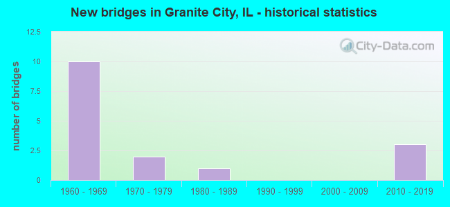
- New bridges - historical statistics
- 101960-1969
- 21970-1979
- 11980-1989
- 32010-2019

- Reconstructed bridges - Historical Statistics
- 41990-1999
- 12000-2009


- Bridge Condition - Deck
- 20.0%Very good
- 20.0%Good
- 50.0%Satisfactory
- 10.0%Fair

- Bridge Condition - Superstructure
- 20.0%Excellent
- 30.0%Good
- 40.0%Satisfactory
- 10.0%Fair

- Bridge Condition - Substructure
- 40.0%Very good
- 40.0%Good
- 10.0%Satisfactory
- 10.0%Fair
Find on map >> Show street view
Structure Number: 600038, Location: .4 M E CHAIN R CNL (Lat: 38.766011, Lng: -90.124222), Route carried "on" structure: Interstate 270, Year Built: 1962, Year Reconstructed: 1997, Status: Open, Structure Length: 7.20m (23.62ft), Average Daily Traffic: 23,300 (year 2021), Truck Traffic: 21%, Average Future Daily Traffic: 27,401 (year 2032), Design Load: HS 20+Mod, Features Intersected: ILL 3
Minimum Vertical Clearance: 30+ m (98+ ft), Kilometerpoint: 4.120, Lanes on structure: 2, Lanes under structure: 4, Base Highway Network: Yes, Owner: State Highway Agency, Approaching Roadway Width: 17.1m (56.1ft), Skew: 1 degrees, Material/Design: Steel, Design/Construction: Stringer/Multi-beam, Number Of Spans In Main Unit: 4, Length of Maximum Span: 22.6m (74.1ft), Curb-To-Curb Width: 15.6m (51.2ft), Out-to-Out Width: 17.9m (58.7ft)
Condition: Deck: Satisfactory, Superstructure: Satisfactory, Substructure: Satisfactory, Operating Rating: 54.4 metric tons, Method Used To Determine Operating Rating: Load Factor (LF) rating reported by rating factor (RF) method using MS18 loading, Inventory Rating: 32.7 metric tons, Method Used To Determine Inventory Rating: Load Factor (LF) rating reported by rating factor (RF) method using MS18 loading, Structural Evaluation: Equal to present minimum criteria, Deck Geometry: Superior to present desirable criteria, Underclear: Meets minimum limits, Approach Roadway Alignment: Equal to present desirable criteria, Designated Inspection Frequency: Every 24 months, Inspection Date: January 2022, Deck Structure Type: Concrete Cast-file-Place, Wearing Surface/Protective System: Deck Protection: Epoxy Coated Reinforcing
Find on map >> Show street view
Structure Number: 600039, Location: .4 M E CHAIN R CNL (Lat: 38.766025, Lng: -90.123850), Route carried "on" structure: Interstate 270, Year Built: 1962, Year Reconstructed: 1998, Status: Open, Structure Length: 7.20m (23.62ft), Average Daily Traffic: 23,300 (year 2021), Truck Traffic: 21%, Average Future Daily Traffic: 27,401 (year 2032), Design Load: HS 20+Mod, Features Intersected: ILL 3
Minimum Vertical Clearance: 30+ m (98+ ft), Kilometerpoint: 4.152, Lanes on structure: 3, Lanes under structure: 4, Base Highway Network: Yes, Owner: State Highway Agency, Approaching Roadway Width: 17.1m (56.1ft), Skew: 1 degrees, Material/Design: Steel, Design/Construction: Stringer/Multi-beam, Number Of Spans In Main Unit: 4, Length of Maximum Span: 22.6m (74.1ft), Curb-To-Curb Width: 17.1m (56.1ft), Out-to-Out Width: 18.1m (59.4ft)
Condition: Deck: Satisfactory, Superstructure: Satisfactory, Substructure: Fair, Operating Rating: 54.4 metric tons, Method Used To Determine Operating Rating: Load Factor (LF) rating reported by rating factor (RF) method using MS18 loading, Inventory Rating: 32.7 metric tons, Method Used To Determine Inventory Rating: Load Factor (LF) rating reported by rating factor (RF) method using MS18 loading, Structural Evaluation: Somewhat better than minimum adequacy, Deck Geometry: Equal to present minimum criteria, Underclear: Meets minimum limits, Approach Roadway Alignment: Equal to present desirable criteria, Length Of Structure Improvement: 7.16m (23.49ft), Designated Inspection Frequency: Every 24 months, Inspection Date: January 2022, Bridge Improvement Cost: $882,000, Roadway Improvement Cost: $88,000, Total Project Cost: $970,000, Deck Structure Type: Concrete Cast-file-Place, Wearing Surface/Protective System: Deck Protection: Epoxy Coated Reinforcing
Find on map >> Show street view
Structure Number: 60004, Location: 1/2 MI E OF IL 3 (Lat: 38.765819, Lng: -90.115750), Route carried "on" structure: Interstate 270, Year Built: 1962, Year Reconstructed: 1997, Status: Open, Structure Length: 7.59m (24.90ft), Average Daily Traffic: 23,300 (year 2021), Truck Traffic: 21%, Average Future Daily Traffic: 27,401 (year 2032), Design Load: HS 20+Mod, Features Intersected: ST THOMAS RD & NW RR
Minimum Vertical Clearance: 30+ m (98+ ft), Kilometerpoint: 4.828, Lanes on structure: 2, Lanes under structure: 2, Base Highway Network: Yes, Owner: State Highway Agency, Approaching Roadway Width: 11.6m (38.1ft), Material/Design: Steel continuous, Design/Construction: Stringer/Multi-beam, Number Of Spans In Main Unit: 4, Length of Maximum Span: 20.9m (68.6ft), Curb-To-Curb Width: 12.4m (40.7ft), Out-to-Out Width: 13.4m (44.0ft)
Condition: Deck: Good, Superstructure: Good, Substructure: Very good, Operating Rating: 67.1 metric tons, Method Used To Determine Operating Rating: Load Factor (LF) rating reported by rating factor (RF) method using MS18 loading, Inventory Rating: 36.0 metric tons, Method Used To Determine Inventory Rating: Load Factor (LF) rating reported by rating factor (RF) method using MS18 loading, Structural Evaluation: Better than present minimum criteria, Deck Geometry: Better than present minimum criteria, Underclear: Superior to present desirable criteria, Approach Roadway Alignment: Equal to present desirable criteria, Designated Inspection Frequency: Every 24 months, Inspection Date: January 2022, Deck Structure Type: Concrete Cast-file-Place, Wearing Surface/Protective System: Deck Protection: Epoxy Coated Reinforcing
Find on map >> Show street view
Structure Number: 600041, Location: 1/2 MI E OF IL 3 (Lat: 38.765803, Lng: -90.115597), Route carried "on" structure: Interstate 270, Year Built: 1962, Year Reconstructed: 1998, Status: Open, Structure Length: 7.59m (24.90ft), Average Daily Traffic: 23,300 (year 2021), Truck Traffic: 21%, Average Future Daily Traffic: 27,401 (year 2032), Design Load: HS 20+Mod, Features Intersected: ST THOMAS RD & NW RR
Minimum Vertical Clearance: 30+ m (98+ ft), Kilometerpoint: 4.844, Lanes on structure: 2, Lanes under structure: 2, Base Highway Network: Yes, Owner: State Highway Agency, Approaching Roadway Width: 12.2m (40.0ft), Material/Design: Steel continuous, Design/Construction: Stringer/Multi-beam, Number Of Spans In Main Unit: 4, Length of Maximum Span: 21.0m (68.9ft), Curb-To-Curb Width: 12.4m (40.7ft), Out-to-Out Width: 13.4m (44.0ft)
Condition: Deck: Good, Superstructure: Good, Substructure: Very good, Operating Rating: 67.1 metric tons, Method Used To Determine Operating Rating: Load Factor (LF) rating reported by rating factor (RF) method using MS18 loading, Inventory Rating: 36.3 metric tons, Method Used To Determine Inventory Rating: Load Factor (LF) rating reported by rating factor (RF) method using MS18 loading, Structural Evaluation: Better than present minimum criteria, Deck Geometry: Better than present minimum criteria, Underclear: Superior to present desirable criteria, Approach Roadway Alignment: Equal to present desirable criteria, Designated Inspection Frequency: Every 24 months, Inspection Date: January 2022, Deck Structure Type: Concrete Cast-file-Place, Wearing Surface/Protective System: Deck Protection: Epoxy Coated Reinforcing
Find on map >> Show street view
Structure Number: 600193, Location: 3.8 M S FAI 270 (Lat: 38.721578, Lng: -90.155492), Route carried "on" structure: State highway 3, Year Built: 1967, Status: Open, Structure Length: 5.30m (17.39ft), Average Daily Traffic: 13,400 (year 2021), Truck Traffic: 17%, Average Future Daily Traffic: 8,957 (year 2032), Design Load: HS 20, Features Intersected: N&W RR
Minimum Vertical Clearance: 30+ m (98+ ft), Kilometerpoint: 247.768, Lanes on structure: 2, Base Highway Network: Yes, Owner: State Highway Agency, Approaching Roadway Width: 12.2m (40.0ft), Material/Design: Steel continuous, Design/Construction: Stringer/Multi-beam, Number Of Spans In Main Unit: 3, Length of Maximum Span: 19.4m (63.6ft), Curb-To-Curb Width: 9.9m (32.5ft), Out-to-Out Width: 11.0m (36.1ft)
Condition: Deck: Satisfactory, Superstructure: Satisfactory, Substructure: Good, Operating Rating: 65.1 metric tons, Method Used To Determine Operating Rating: Load Factor (LF) rating reported by rating factor (RF) method using MS18 loading, Inventory Rating: 34.7 metric tons, Method Used To Determine Inventory Rating: Load Factor (LF) rating reported by rating factor (RF) method using MS18 loading, Structural Evaluation: Equal to present minimum criteria, Deck Geometry: Meets minimum limits, Underclear: Superior to present desirable criteria, Approach Roadway Alignment: Equal to present desirable criteria, Designated Inspection Frequency: Every 24 months, Inspection Date: September 2021, Deck Structure Type: Concrete Cast-file-Place, Wearing Surface/Protective System: Wearing Surface: Other
Find on map >> Show street view
Structure Number: 600194, Location: 3.8 M S FAI 270 (Lat: 38.721442, Lng: -90.155619), Route carried "on" structure: State highway 3, Year Built: 1967, Status: Open, Structure Length: 5.30m (17.39ft), Average Daily Traffic: 13,400 (year 2021), Truck Traffic: 17%, Average Future Daily Traffic: 8,957 (year 2032), Design Load: HS 20, Features Intersected: N&W RR
Minimum Vertical Clearance: 30+ m (98+ ft), Kilometerpoint: 247.752, Lanes on structure: 2, Base Highway Network: Yes, Owner: State Highway Agency, Approaching Roadway Width: 12.2m (40.0ft), Material/Design: Steel continuous, Design/Construction: Stringer/Multi-beam, Number Of Spans In Main Unit: 3, Length of Maximum Span: 19.4m (63.6ft), Curb-To-Curb Width: 9.9m (32.5ft), Out-to-Out Width: 11.0m (36.1ft)
Condition: Deck: Satisfactory, Superstructure: Satisfactory, Substructure: Good, Operating Rating: 65.1 metric tons, Method Used To Determine Operating Rating: Load Factor (LF) rating reported by rating factor (RF) method using MS18 loading, Inventory Rating: 34.7 metric tons, Method Used To Determine Inventory Rating: Load Factor (LF) rating reported by rating factor (RF) method using MS18 loading, Structural Evaluation: Equal to present minimum criteria, Deck Geometry: Meets minimum limits, Underclear: Superior to present desirable criteria, Approach Roadway Alignment: Equal to present desirable criteria, Designated Inspection Frequency: Every 24 months, Inspection Date: September 2021, Deck Structure Type: Concrete Cast-file-Place, Wearing Surface/Protective System: Wearing Surface: Other
Find on map >> Show street view
Structure Number: 600202, Location: ARMY DEPOT RR YARD (Lat: 38.699294, Lng: -90.167728), Route carried "on" structure: State highway 3, Year Built: 1975, Status: Open, Structure Length: 17.96m (58.92ft), Average Daily Traffic: 11,700 (year 2021), Truck Traffic: 17%, Average Future Daily Traffic: 14,946 (year 2032), Design Load: HS 20, Features Intersected: RR YARD
Minimum Vertical Clearance: 30+ m (98+ ft), Kilometerpoint: 244.807, Lanes on structure: 6, Base Highway Network: Yes, Owner: State Highway Agency, Approaching Roadway Width: 14.0m (45.9ft), Skew: 32 degrees, Material/Design: Prestressed concrete, Design/Construction: Stringer/Multi-beam, Number Of Spans In Main Unit: 11, Length of Maximum Span: 19.1m (62.7ft), Curb-To-Curb Width: 29.1m (95.5ft), Out-to-Out Width: 30.8m (101.0ft)
Condition: Deck: Fair, Superstructure: Fair, Substructure: Good, Operating Rating: 49.2 metric tons, Method Used To Determine Operating Rating: Load Factor (LF) rating reported by rating factor (RF) method using MS18 loading, Inventory Rating: 29.5 metric tons, Method Used To Determine Inventory Rating: Load Factor (LF) rating reported by rating factor (RF) method using MS18 loading, Structural Evaluation: Somewhat better than minimum adequacy, Deck Geometry: Superior to present desirable criteria, Underclear: Somewhat better than minimum adequacy, Approach Roadway Alignment: Equal to present desirable criteria, Designated Inspection Frequency: Every 24 months, Inspection Date: September 2021, Deck Structure Type: Concrete Cast-file-Place, Wearing Surface/Protective System: Wearing Surface: Bituminous, Membrane: Built-up
Find on map >> Show street view
Structure Number: 6062, Location: IN GRANITECITY (Lat: 38.708594, Lng: -90.105778), Route carried "on" structure: Other road , Year Built: 1976, Status: Open, Structure Length: 1.60m (5.25ft), Average Daily Traffic: 3,250 (year 2021), Truck Traffic: 6%, Average Future Daily Traffic: 3,922 (year 2032), Design Load: HS 20, Features Intersected: DRAINAGE DITCH, Facility Carried by Structure: MARYVILLE RD/FAU91
Minimum Vertical Clearance: 30+ m (98+ ft), Kilometerpoint: 3.396, Lanes on structure: 4, Base Highway Network: Yes, Owner: City or Municipal Highway Agency, Approaching Roadway Width: 18.3m (60.0ft), Skew: 4 degrees, Material/Design: Concrete, Design/Construction: Culvert, Number Of Spans In Main Unit: 2, Length of Maximum Span: 4.3m (14.1ft)
Condition: Channel: Very good, Culverts: Good, Operating Rating: 44.4 metric tons, Method Used To Determine Operating Rating: Assigned rating based on Load Factor Design (LFD) reported by rating factor (RF) using MS18 loading, Inventory Rating: 32.4 metric tons, Method Used To Determine Inventory Rating: Assigned rating based on Load Factor Design (LFD) reported by rating factor (RF) using MS18 loading, Structural Evaluation: Better than present minimum criteria, Waterway Adequacy: Equal to present desirable criteria, Approach Roadway Alignment: Equal to present desirable criteria, Designated Inspection Frequency: Every 48 months, Inspection Date: January 2020
Find on map >> Show street view
Structure Number: 606201, Location: 19ST OVER NOFLK&WSRR (Lat: 38.705086, Lng: -90.156747), Route carried "on" structure: Other road , Year Built: 1981, Year Reconstructed: 2013, Status: Open, Structure Length: 28.96m (95.01ft), Average Daily Traffic: 6,300 (year 2021), Truck Traffic: 20%, Average Future Daily Traffic: 10,070 (year 2032), Design Load: HS 20, Features Intersected: TRRA&NEW CONRR&ICGRR, Facility Carried by Structure: FAU 9093/19TH STRE
Minimum Vertical Clearance: 30+ m (98+ ft), Kilometerpoint: 1.223, Lanes on structure: 2, Base Highway Network: Yes, Owner: City or Municipal Highway Agency, Approaching Roadway Width: 9.8m (32.2ft), Material/Design: Steel continuous, Design/Construction: Stringer/Multi-beam, Number Of Spans In Main Unit: 9, Length of Maximum Span: 35.7m (117.1ft), Curb or Sidewalk Widths: Left: 0.0m, Right: 1.5m (4.9ft), Curb-To-Curb Width: 10.7m (35.1ft), Out-to-Out Width: 11.8m (38.7ft)
Condition: Deck: Satisfactory, Superstructure: Good, Substructure: Good, Operating Rating: 53.8 metric tons, Method Used To Determine Operating Rating: Load Factor (LF) rating reported by rating factor (RF) method using MS18 loading, Inventory Rating: 32.4 metric tons, Method Used To Determine Inventory Rating: Load Factor (LF) rating reported by rating factor (RF) method using MS18 loading, Structural Evaluation: Better than present minimum criteria, Deck Geometry: Meets minimum limits, Underclear: Meets minimum limits, Approach Roadway Alignment: Equal to present desirable criteria, Designated Inspection Frequency: Every 24 months, Inspection Date: January 2022, Deck Structure Type: Concrete Cast-file-Place
Find on map >> Show street view
Structure Number: 606202, Location: 2.5 mile S of I-270 (Lat: 38.731539, Lng: -90.125761), Route carried "on" structure: Other road , Year Built: 2010, Status: Open, Structure Length: 11.72m (38.45ft), Average Daily Traffic: 8,750 (year 2021), Truck Traffic: 8%, Average Future Daily Traffic: 14,276 (year 2031), Design Load: HS 20, Features Intersected: UPRR, KCSRR, NSRR, Facility Carried by Structure: Pontoon Road
Minimum Vertical Clearance: 30+ m (98+ ft), Kilometerpoint: 1.384, Lanes on structure: 4, Base Highway Network: Yes, Owner: City or Municipal Highway Agency, Approaching Roadway Width: 15.8m (51.8ft), Material/Design: Steel continuous, Design/Construction: Stringer/Multi-beam, Number Of Spans In Main Unit: 5, Length of Maximum Span: 29.7m (97.4ft), Curb or Sidewalk Widths: Left: 1.5m (4.9ft), Right: 1.5m (4.9ft), Curb-To-Curb Width: 17.1m (56.1ft), Out-to-Out Width: 21.7m (71.2ft)
Condition: Deck: Very good, Superstructure: Excellent, Substructure: Very good, Operating Rating: 42.1 metric tons, Method Used To Determine Operating Rating: Assigned ratings based on Load and Resistance Factor Design (LRFD) reported by rating factor (RF) using HL93 loadings, Inventory Rating: 32.4 metric tons, Method Used To Determine Inventory Rating: Assigned ratings based on Load and Resistance Factor Design (LRFD) reported by rating factor (RF) using HL93 loadings, Structural Evaluation: Equal to present desirable criteria, Deck Geometry: Somewhat better than minimum adequacy, Underclear: Superior to present desirable criteria, Approach Roadway Alignment: Equal to present desirable criteria, Designated Inspection Frequency: Every 48 months, Inspection Date: November 2019, Deck Structure Type: Concrete Cast-file-Place, Wearing Surface/Protective System: Deck Protection: Epoxy Coated Reinforcing
Find on map >> Show street view
Structure Number: 606203, Location: 2.5 miles S of I-270 (Lat: 38.731550, Lng: -90.123967), Route carried "on" structure: Other road , Year Built: 2010, Status: Open, Structure Length: 2.77m (9.09ft), Average Daily Traffic: 8,750 (year 2021), Truck Traffic: 8%, Average Future Daily Traffic: 14,276 (year 2031), Design Load: HS 20, Features Intersected: IL Rte 203, Facility Carried by Structure: Pontoon Road
Minimum Vertical Clearance: 30+ m (98+ ft), Kilometerpoint: 1.529, Lanes on structure: 4, Lanes under structure: 4, Base Highway Network: Yes, Owner: City or Municipal Highway Agency, Approaching Roadway Width: 15.8m (51.8ft), Material/Design: Steel continuous, Design/Construction: Stringer/Multi-beam, Number Of Spans In Main Unit: 1, Length of Maximum Span: 26.9m (88.3ft), Curb or Sidewalk Widths: Left: 1.5m (4.9ft), Right: 1.5m (4.9ft), Curb-To-Curb Width: 17.1m (56.1ft), Out-to-Out Width: 21.7m (71.2ft)
Condition: Deck: Very good, Superstructure: Excellent, Substructure: Very good, Operating Rating: 42.1 metric tons, Method Used To Determine Operating Rating: Assigned ratings based on Load and Resistance Factor Design (LRFD) reported by rating factor (RF) using HL93 loadings, Inventory Rating: 32.4 metric tons, Method Used To Determine Inventory Rating: Assigned ratings based on Load and Resistance Factor Design (LRFD) reported by rating factor (RF) using HL93 loadings, Structural Evaluation: Equal to present desirable criteria, Deck Geometry: Somewhat better than minimum adequacy, Approach Roadway Alignment: Equal to present desirable criteria, Designated Inspection Frequency: Every 48 months, Inspection Date: November 2019, Deck Structure Type: Concrete Cast-file-Place, Wearing Surface/Protective System: Deck Protection: Epoxy Coated Reinforcing
Find on map >> Show street view
Structure Number: 600038, Location: .4 M E CHAIN R CNL (Lat: 38.766011, Lng: -90.124222), Route carried "under" structure: State highway 3, Year Built: 1962, Structure Length: 0. m, Average Daily Traffic: 11,300 (year 2021), Truck Traffic: 15%, Features Intersected: ILL 3, Facility Carried by Structure: FAI 270 EB
Minimum Vertical Clearance: 4.55m (14.93ft), Kilometerpoint: 253.787, Lanes on structure: 2, Lanes under structure: 4, Material/Design: Steel, Design/Construction: Stringer/Multi-beam, Length of Maximum Span: 22.6m (74.1ft)
Find on map >> Show street view
Structure Number: 600039, Location: .4 M E CHAIN R CNL (Lat: 38.766197, Lng: -90.124181), Route carried "under" structure: State highway 3, Year Built: 1962, Structure Length: 0. m, Average Daily Traffic: 11,800 (year 2021), Truck Traffic: 14%, Features Intersected: ILL 3, Facility Carried by Structure: FAI 270 WB
Minimum Vertical Clearance: 4.55m (14.93ft), Kilometerpoint: 253.819, Lanes on structure: 3, Lanes under structure: 4, Material/Design: Steel, Design/Construction: Stringer/Multi-beam, Length of Maximum Span: 22.6m (74.1ft)
Find on map >> Show street view
Structure Number: 60004, Location: 1/2 MI E OF IL 3 (Lat: 38.765592, Lng: -90.115839), Route carried "under" structure: Other road , Year Built: 1962, Structure Length: 0. m, Average Daily Traffic: 850 (year 2021), Truck Traffic: 8%, Features Intersected: ST THOMAS RD & NW RR, Facility Carried by Structure: FAI 270 EB
Minimum Vertical Clearance: 7.14m (23.43ft), Kilometerpoint: 1.658, Lanes on structure: 2, Lanes under structure: 2, Material/Design: Steel continuous, Design/Construction: Stringer/Multi-beam, Length of Maximum Span: 20.9m (68.6ft)
Find on map >> Show street view
Structure Number: 600041, Location: 1/2 MI E OF IL 3 (Lat: 38.765819, Lng: -90.115750), Route carried "under" structure: Other road , Year Built: 1962, Structure Length: 0. m, Average Daily Traffic: 850 (year 2021), Truck Traffic: 8%, Features Intersected: ST THOMAS RD & NW RR, Facility Carried by Structure: FAI 270 WB
Minimum Vertical Clearance: 7.19m (23.59ft), Kilometerpoint: 1.625, Lanes on structure: 2, Lanes under structure: 2, Material/Design: Steel continuous, Design/Construction: Stringer/Multi-beam, Length of Maximum Span: 21.0m (68.9ft)
Find on map >> Show street view
Structure Number: 606203, Location: 2.5 miles S of I-270 (Lat: 38.731550, Lng: -90.123967), Route carried "under" structure: State highway 203, Year Built: 2010, Structure Length: 0. m, Average Daily Traffic: 15,000 (year 2021), Truck Traffic: 6%, Features Intersected: IL Rte 203, Facility Carried by Structure: Pontoon Road
Minimum Vertical Clearance: 5.03m (16.50ft), Kilometerpoint: 11.732, Lanes on structure: 4, Lanes under structure: 4, Material/Design: Steel continuous, Design/Construction: Stringer/Multi-beam, Length of Maximum Span: 26.9m (88.3ft)