Bridge Statistics for Glen Carbon, Illinois (IL)
Condition, Traffic, Stress, Structural Evaluation, Project Costs
- National Bridge Inventory (NBI) Statistics
- 28Number of bridges
- 361ft / 110mTotal length
- $1,222,000Total costs
- 560,420Total average daily traffic
- 100,864Total average daily truck traffic
- National Bridge Inventory (NBI) Registered Bridges for Glen Carbon
- No street view available for this location
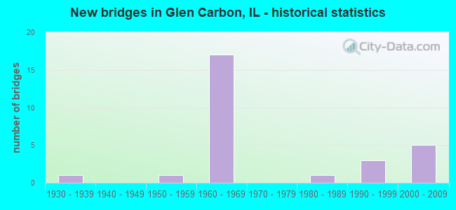
- New bridges - historical statistics
- 11930-1939
- 11950-1959
- 171960-1969
- 11980-1989
- 31990-1999
- 52000-2009

- Reconstructed bridges - Historical Statistics
- 11970-1979
- 01980-1989
- 41990-1999
- 32000-2009


- Bridge Condition - Deck
- 17.6%Very good
- 29.4%Good
- 41.2%Satisfactory
- 11.8%Fair

- Bridge Condition - Superstructure
- 35.3%Very good
- 23.5%Good
- 29.4%Satisfactory
- 5.9%Fair
- 5.9%Serious

- Bridge Condition - Substructure
- 35.3%Very good
- 52.9%Good
- 5.9%Satisfactory
- 5.9%Serious

- Bridge Condition - Channel
- 36.4%Very good
- 45.5%Good
- 18.2%Fair

- Bridge Condition - Culverts
- 50.0%Good
- 50.0%Satisfactory
Find on map >> Show street view
Structure Number: 600051, Location: 1.4 M E ILL 157 (Lat: 38.756683, Lng: -89.981567), Route carried "on" structure: Interstate 270, Year Built: 1963, Year Reconstructed: 2006, Status: Open, Structure Length: 8.29m (27.20ft), Average Daily Traffic: 28,050 (year 2021), Truck Traffic: 18%, Average Future Daily Traffic: 21,783 (year 2032), Design Load: HS 20+Mod, Features Intersected: BIKE TRAIL/STREAM
Minimum Vertical Clearance: 30+ m (98+ ft), Kilometerpoint: 16.721, Lanes on structure: 2, Base Highway Network: Yes, Owner: State Highway Agency, Approaching Roadway Width: 13.4m (44.0ft), Skew: 1 degrees, Material/Design: Steel continuous, Design/Construction: Stringer/Multi-beam, Number Of Spans In Main Unit: 5, Length of Maximum Span: 18.5m (60.7ft), Curb-To-Curb Width: 12.2m (40.0ft), Out-to-Out Width: 13.2m (43.3ft)
Condition: Deck: Satisfactory, Superstructure: Very good, Substructure: Good, Channel: Very good, Operating Rating: 89.1 metric tons, Method Used To Determine Operating Rating: Load Factor (LF) rating reported by rating factor (RF) method using MS18 loading, Inventory Rating: 62.5 metric tons, Method Used To Determine Inventory Rating: Load Factor (LF) rating reported by rating factor (RF) method using MS18 loading, Structural Evaluation: Better than present minimum criteria, Deck Geometry: Better than present minimum criteria, Waterway Adequacy: Superior to present desirable criteria, Approach Roadway Alignment: Equal to present desirable criteria, Designated Inspection Frequency: Every 24 months, Inspection Date: January 2022, Deck Structure Type: Concrete Cast-file-Place, Wearing Surface/Protective System: Deck Protection: Epoxy Coated Reinforcing
Find on map >> Show street view
Structure Number: 600052, Location: 1.4 M E ILL 157 (Lat: 38.756686, Lng: -89.981375), Route carried "on" structure: Interstate 270, Year Built: 1963, Year Reconstructed: 2006, Status: Open, Structure Length: 8.29m (27.20ft), Average Daily Traffic: 28,050 (year 2021), Truck Traffic: 18%, Average Future Daily Traffic: 21,783 (year 2032), Design Load: HS 20+Mod, Features Intersected: BIKE TRAIL/STREAM
Minimum Vertical Clearance: 30+ m (98+ ft), Kilometerpoint: 16.737, Lanes on structure: 2, Base Highway Network: Yes, Owner: State Highway Agency, Approaching Roadway Width: 13.4m (44.0ft), Skew: 1 degrees, Material/Design: Steel continuous, Design/Construction: Stringer/Multi-beam, Number Of Spans In Main Unit: 5, Length of Maximum Span: 18.5m (60.7ft), Curb-To-Curb Width: 12.2m (40.0ft), Out-to-Out Width: 13.2m (43.3ft)
Condition: Deck: Satisfactory, Superstructure: Good, Substructure: Good, Channel: Very good, Operating Rating: 89.1 metric tons, Method Used To Determine Operating Rating: Load Factor (LF) rating reported by rating factor (RF) method using MS18 loading, Inventory Rating: 62.5 metric tons, Method Used To Determine Inventory Rating: Load Factor (LF) rating reported by rating factor (RF) method using MS18 loading, Structural Evaluation: Better than present minimum criteria, Deck Geometry: Better than present minimum criteria, Waterway Adequacy: Superior to present desirable criteria, Approach Roadway Alignment: Equal to present desirable criteria, Designated Inspection Frequency: Every 24 months, Inspection Date: January 2022, Deck Structure Type: Concrete Cast-file-Place, Wearing Surface/Protective System: Deck Protection: Epoxy Coated Reinforcing
Find on map >> Show street view
Structure Number: 600055, Location: 1.3 M W FAI 55 (Lat: 38.752081, Lng: -89.929069), Route carried "on" structure: Interstate 270, Year Built: 1964, Year Reconstructed: 1996, Status: Open, Structure Length: 7.86m (25.79ft), Average Daily Traffic: 14,400 (year 2021), Truck Traffic: 31%, Average Future Daily Traffic: 15,264 (year 2032), Design Load: HS 20+Mod, Features Intersected: OLD TROY RD/MCT TRL
Minimum Vertical Clearance: 30+ m (98+ ft), Kilometerpoint: 21.275, Lanes on structure: 2, Lanes under structure: 2, Base Highway Network: Yes, Owner: State Highway Agency, Approaching Roadway Width: 13.4m (44.0ft), Skew: 3 degrees, Material/Design: Steel continuous, Design/Construction: Stringer/Multi-beam, Number Of Spans In Main Unit: 4, Length of Maximum Span: 21.0m (68.9ft), Curb-To-Curb Width: 12.2m (40.0ft), Out-to-Out Width: 13.2m (43.3ft)
Condition: Deck: Satisfactory, Superstructure: Good, Substructure: Good, Operating Rating: 87.8 metric tons, Method Used To Determine Operating Rating: Load Factor (LF) rating reported by rating factor (RF) method using MS18 loading, Inventory Rating: 52.8 metric tons, Method Used To Determine Inventory Rating: Load Factor (LF) rating reported by rating factor (RF) method using MS18 loading, Structural Evaluation: Better than present minimum criteria, Deck Geometry: Better than present minimum criteria, Underclear: Superior to present desirable criteria, Approach Roadway Alignment: Equal to present desirable criteria, Designated Inspection Frequency: Every 24 months, Inspection Date: January 2022, Deck Structure Type: Concrete Cast-file-Place, Wearing Surface/Protective System: Deck Protection: Epoxy Coated Reinforcing
Find on map >> Show street view
Structure Number: 600056, Location: 1.3 M W FAI 55 & 70 (Lat: 38.752064, Lng: -89.928894), Route carried "on" structure: Interstate 270, Year Built: 1964, Year Reconstructed: 1996, Status: Open, Structure Length: 7.86m (25.79ft), Average Daily Traffic: 14,400 (year 2021), Truck Traffic: 31%, Average Future Daily Traffic: 15,264 (year 2032), Design Load: HS 20+Mod, Features Intersected: OLD TROY RD/MCT TRL
Minimum Vertical Clearance: 30+ m (98+ ft), Kilometerpoint: 21.291, Lanes on structure: 2, Lanes under structure: 2, Base Highway Network: Yes, Owner: State Highway Agency, Approaching Roadway Width: 13.4m (44.0ft), Skew: 3 degrees, Material/Design: Steel continuous, Design/Construction: Stringer/Multi-beam, Number Of Spans In Main Unit: 4, Length of Maximum Span: 21.0m (68.9ft), Curb-To-Curb Width: 12.2m (40.0ft), Out-to-Out Width: 13.2m (43.3ft)
Condition: Deck: Satisfactory, Superstructure: Satisfactory, Substructure: Good, Operating Rating: 87.8 metric tons, Method Used To Determine Operating Rating: Load Factor (LF) rating reported by rating factor (RF) method using MS18 loading, Inventory Rating: 52.8 metric tons, Method Used To Determine Inventory Rating: Load Factor (LF) rating reported by rating factor (RF) method using MS18 loading, Structural Evaluation: Equal to present minimum criteria, Deck Geometry: Better than present minimum criteria, Underclear: Superior to present desirable criteria, Approach Roadway Alignment: Equal to present desirable criteria, Designated Inspection Frequency: Every 24 months, Inspection Date: January 2022, Deck Structure Type: Concrete Cast-file-Place, Wearing Surface/Protective System: Deck Protection: Epoxy Coated Reinforcing
Find on map >> Show street view
Structure Number: 600085, Location: 1.5 MI N PETERS STA (Lat: 38.756433, Lng: -90.007656), Route carried "on" structure: State highway 157, Year Built: 1963, Year Reconstructed: 2001, Status: Open, Structure Length: 7.25m (23.79ft), Average Daily Traffic: 9,750 (year 2021), Truck Traffic: 6%, Average Future Daily Traffic: 9,328 (year 2032), Design Load: HS 20, Features Intersected: FAI 270
Minimum Vertical Clearance: 30+ m (98+ ft), Kilometerpoint: 34.857, Lanes on structure: 2, Lanes under structure: 4, Base Highway Network: Yes, Owner: State Highway Agency, Approaching Roadway Width: 11.6m (38.1ft), Skew: 1 degrees, Material/Design: Steel continuous, Design/Construction: Stringer/Multi-beam, Number Of Spans In Main Unit: 4, Length of Maximum Span: 21.3m (69.9ft), Curb-To-Curb Width: 8.4m (27.6ft), Out-to-Out Width: 10.1m (33.1ft)
Condition: Deck: Satisfactory, Superstructure: Satisfactory, Substructure: Very good, Operating Rating: 57.0 metric tons, Method Used To Determine Operating Rating: Load Factor (LF) rating reported by rating factor (RF) method using MS18 loading, Inventory Rating: 34.3 metric tons, Method Used To Determine Inventory Rating: Load Factor (LF) rating reported by rating factor (RF) method using MS18 loading, Structural Evaluation: Equal to present minimum criteria, Deck Geometry: High priority of corrective action, Underclear: Meets minimum limits, Approach Roadway Alignment: Equal to present desirable criteria, Length Of Structure Improvement: 7.25m (23.79ft), Designated Inspection Frequency: Every 24 months, Inspection Date: November 2021, Bridge Improvement Cost: $555,000, Roadway Improvement Cost: $56,000, Total Project Cost: $611,000, Deck Structure Type: Concrete Cast-file-Place, Wearing Surface/Protective System: Wearing Surface: Other
Find on map >> Show street view
Structure Number: 600086, Location: 1.5 MI N PETERS STA (Lat: 38.756225, Lng: -90.007586), Route carried "on" structure: State highway 157, Year Built: 1963, Year Reconstructed: 2001, Status: Open, Structure Length: 7.25m (23.79ft), Average Daily Traffic: 9,750 (year 2021), Truck Traffic: 6%, Average Future Daily Traffic: 9,328 (year 2032), Design Load: HS 20, Features Intersected: FAI 270
Minimum Vertical Clearance: 30+ m (98+ ft), Kilometerpoint: 34.841, Lanes on structure: 2, Lanes under structure: 4, Base Highway Network: Yes, Owner: State Highway Agency, Approaching Roadway Width: 11.6m (38.1ft), Skew: 1 degrees, Material/Design: Steel continuous, Design/Construction: Stringer/Multi-beam, Number Of Spans In Main Unit: 4, Length of Maximum Span: 21.3m (69.9ft), Curb-To-Curb Width: 8.4m (27.6ft), Out-to-Out Width: 10.1m (33.1ft)
Condition: Deck: Good, Superstructure: Satisfactory, Substructure: Very good, Operating Rating: 57.0 metric tons, Method Used To Determine Operating Rating: Load Factor (LF) rating reported by rating factor (RF) method using MS18 loading, Inventory Rating: 34.3 metric tons, Method Used To Determine Inventory Rating: Load Factor (LF) rating reported by rating factor (RF) method using MS18 loading, Structural Evaluation: Equal to present minimum criteria, Deck Geometry: High priority of corrective action, Underclear: Meets minimum limits, Approach Roadway Alignment: Equal to present desirable criteria, Length Of Structure Improvement: 7.25m (23.79ft), Designated Inspection Frequency: Every 24 months, Inspection Date: November 2021, Bridge Improvement Cost: $555,000, Roadway Improvement Cost: $56,000, Total Project Cost: $611,000, Deck Structure Type: Concrete Cast-file-Place, Wearing Surface/Protective System: Wearing Surface: Other
Find on map >> Show street view
Structure Number: 600087, Location: JCT 157-162 (Lat: 38.741253, Lng: -90.002006), Route carried "on" structure: State highway 157, Year Built: 1933, Year Reconstructed: 1982, Status: Open, Structure Length: 3.69m (12.11ft), Average Daily Traffic: 10,100 (year 2021), Truck Traffic: 6%, Average Future Daily Traffic: 13,144 (year 2032), Design Load: HS 20, Features Intersected: JUDY'S BRANCH CREEK
Minimum Vertical Clearance: 30+ m (98+ ft), Kilometerpoint: 33.055, Lanes on structure: 2, Base Highway Network: Yes, Owner: State Highway Agency, Approaching Roadway Width: 12.5m (41.0ft), Material/Design: Steel, Design/Construction: Stringer/Multi-beam, Number Of Spans In Main Unit: 3, Length of Maximum Span: 12.0m (39.4ft), Curb-To-Curb Width: 13.5m (44.3ft), Out-to-Out Width: 14.5m (47.6ft)
Condition: Deck: Satisfactory, Superstructure: Serious, Substructure: Serious, Channel: Good, Operating Rating: 82.3 metric tons, Method Used To Determine Operating Rating: Load Factor (LF) rating reported by rating factor (RF) method using MS18 loading, Inventory Rating: 49.6 metric tons, Method Used To Determine Inventory Rating: Load Factor (LF) rating reported by rating factor (RF) method using MS18 loading, Structural Evaluation: High priority of corrective action, Deck Geometry: Superior to present desirable criteria, Waterway Adequacy: Superior to present desirable criteria, Approach Roadway Alignment: Equal to present minimum criteria, Designated Inspection Frequency: Every 12 months, Other Special Inspection Frequency: Every 24 months, Inspection Date: June 2021, Other Special Inspection Date: June 2020, Deck Structure Type: Concrete Cast-file-Place, Wearing Surface/Protective System: Deck Protection: Epoxy Coated Reinforcing
Find on map >> Show street view
Structure Number: 600175, Location: 0.26 ME JCT 159 (Lat: 38.754994, Lng: -89.951881), Route carried "on" structure: City street , Year Built: 1964, Status: Open, Structure Length: 7.93m (26.02ft), Average Daily Traffic: 800 (year 2021), Truck Traffic: 6%, Average Future Daily Traffic: 1,166 (year 2032), Design Load: HS 15, Features Intersected: I-270, Facility Carried by Structure: OAK LAWN RD-MSS 90
Minimum Vertical Clearance: 30+ m (98+ ft), Kilometerpoint: 0.177, Lanes on structure: 2, Lanes under structure: 4, Owner: State Highway Agency, Approaching Roadway Width: 7.3m (24.0ft), Skew: 1 degrees, Material/Design: Steel continuous, Design/Construction: Stringer/Multi-beam, Number Of Spans In Main Unit: 4, Length of Maximum Span: 25.6m (84.0ft), Curb or Sidewalk Widths: Left: 0.6m (2.0ft), Right: 0.6m (2.0ft), Curb-To-Curb Width: 7.3m (24.0ft), Out-to-Out Width: 9.1m (29.9ft)
Condition: Deck: Fair, Superstructure: Good, Substructure: Good, Operating Rating: 58.6 metric tons, Method Used To Determine Operating Rating: Load Factor (LF) rating reported by rating factor (RF) method using MS18 loading, Inventory Rating: 35.3 metric tons, Method Used To Determine Inventory Rating: Load Factor (LF) rating reported by rating factor (RF) method using MS18 loading, Structural Evaluation: Better than present minimum criteria, Deck Geometry: Meets minimum limits, Underclear: Somewhat better than minimum adequacy, Approach Roadway Alignment: Equal to present minimum criteria, Designated Inspection Frequency: Every 24 months, Other Special Inspection Frequency: Every 48 months, Inspection Date: January 2022, Other Special Inspection Date: April 2018, Deck Structure Type: Concrete Cast-file-Place, Wearing Surface/Protective System: Wearing Surface: Other
Find on map >> Show street view
Structure Number: 600184, Location: 1 M W JCT 159 (Lat: 38.757214, Lng: -89.974717), Route carried "on" structure: Other road , Year Built: 1963, Status: Open, Structure Length: 6.83m (22.41ft), Average Daily Traffic: 5,750 (year 2021), Truck Traffic: 3%, Average Future Daily Traffic: 6,572 (year 2032), Design Load: HS 20, Features Intersected: FAI 270, Facility Carried by Structure: Main St
Minimum Vertical Clearance: 30+ m (98+ ft), Kilometerpoint: 2.575, Lanes on structure: 2, Lanes under structure: 4, Base Highway Network: Yes, Owner: State Highway Agency, Approaching Roadway Width: 8.5m (27.9ft), Material/Design: Steel continuous, Design/Construction: Stringer/Multi-beam, Number Of Spans In Main Unit: 4, Length of Maximum Span: 20.7m (67.9ft), Curb or Sidewalk Widths: Left: 0.6m (2.0ft), Right: 0.6m (2.0ft), Curb-To-Curb Width: 8.5m (27.9ft), Out-to-Out Width: 10.2m (33.5ft)
Condition: Deck: Good, Superstructure: Satisfactory, Substructure: Good, Operating Rating: 63.8 metric tons, Method Used To Determine Operating Rating: Load Factor (LF) rating reported by rating factor (RF) method using MS18 loading, Inventory Rating: 38.2 metric tons, Method Used To Determine Inventory Rating: Load Factor (LF) rating reported by rating factor (RF) method using MS18 loading, Structural Evaluation: Equal to present minimum criteria, Deck Geometry: Meets minimum limits, Underclear: Meets minimum limits, Approach Roadway Alignment: Equal to present desirable criteria, Designated Inspection Frequency: Every 24 months, Inspection Date: January 2022, Deck Structure Type: Concrete Cast-file-Place, Wearing Surface/Protective System: Wearing Surface: Other
Find on map >> Show street view
Structure Number: 600185, Location: 1.25 MI E OF IL 157 (Lat: 38.756639, Lng: -89.984411), Route carried "on" structure: Other road , Year Built: 1963, Year Reconstructed: 2000, Status: Open, Structure Length: 6.70m (21.98ft), Average Daily Traffic: 4,300 (year 2021), Truck Traffic: 3%, Average Future Daily Traffic: 3,975 (year 2032), Design Load: HS 20, Features Intersected: FAI 270, Facility Carried by Structure: Meridian Rd
Minimum Vertical Clearance: 30+ m (98+ ft), Kilometerpoint: 2.301, Lanes on structure: 2, Lanes under structure: 4, Owner: State Highway Agency, Approaching Roadway Width: 9.2m (30.2ft), Material/Design: Steel continuous, Design/Construction: Stringer/Multi-beam, Number Of Spans In Main Unit: 4, Length of Maximum Span: 20.5m (67.3ft), Curb or Sidewalk Widths: Left: 0.0m, Right: 1.7m (5.6ft), Curb-To-Curb Width: 9.2m (30.2ft), Out-to-Out Width: 11.9m (39.0ft)
Condition: Deck: Very good, Superstructure: Satisfactory, Substructure: Good, Operating Rating: 71.9 metric tons, Method Used To Determine Operating Rating: Load Factor (LF) rating reported by rating factor (RF) method using MS18 loading, Inventory Rating: 43.1 metric tons, Method Used To Determine Inventory Rating: Load Factor (LF) rating reported by rating factor (RF) method using MS18 loading, Structural Evaluation: Equal to present minimum criteria, Deck Geometry: Meets minimum limits, Underclear: Meets minimum limits, Approach Roadway Alignment: Equal to present minimum criteria, Designated Inspection Frequency: Every 24 months, Inspection Date: January 2022, Deck Structure Type: Concrete Cast-file-Place, Wearing Surface/Protective System: Deck Protection: Epoxy Coated Reinforcing
Find on map >> Show street view
Structure Number: 600319, Location: WEST OF IL 159 (Lat: 38.756794, Lng: -89.967856), Route carried "on" structure: Interstate 270, Year Built: 1996, Status: Open, Structure Length: 9.85m (32.32ft), Average Daily Traffic: 28,050 (year 2021), Truck Traffic: 18%, Average Future Daily Traffic: 21,783 (year 2032), Design Load: HS 20, Features Intersected: JUDYS BR & MCT Trail
Minimum Vertical Clearance: 30+ m (98+ ft), Kilometerpoint: 17.928, Lanes on structure: 2, Base Highway Network: Yes, Owner: State Highway Agency, Approaching Roadway Width: 13.4m (44.0ft), Material/Design: Steel continuous, Design/Construction: Stringer/Multi-beam, Number Of Spans In Main Unit: 4, Length of Maximum Span: 30.5m (100.1ft), Curb-To-Curb Width: 12.2m (40.0ft), Out-to-Out Width: 13.2m (43.3ft)
Condition: Deck: Good, Superstructure: Very good, Substructure: Good, Channel: Very good, Operating Rating: 55.4 metric tons, Method Used To Determine Operating Rating: Load Factor (LF) rating reported by rating factor (RF) method using MS18 loading, Inventory Rating: 33.0 metric tons, Method Used To Determine Inventory Rating: Load Factor (LF) rating reported by rating factor (RF) method using MS18 loading, Structural Evaluation: Better than present minimum criteria, Deck Geometry: Better than present minimum criteria, Waterway Adequacy: Superior to present desirable criteria, Approach Roadway Alignment: Equal to present desirable criteria, Designated Inspection Frequency: Every 24 months, Inspection Date: January 2022, Deck Structure Type: Concrete Cast-file-Place, Wearing Surface/Protective System: Deck Protection: Epoxy Coated Reinforcing
Find on map >> Show street view
Structure Number: 60032, Location: WEST OF IL 159 (Lat: 38.756794, Lng: -89.967678), Route carried "on" structure: Interstate 270, Year Built: 1996, Status: Open, Structure Length: 9.85m (32.32ft), Average Daily Traffic: 28,050 (year 2021), Truck Traffic: 18%, Average Future Daily Traffic: 21,783 (year 2032), Design Load: HS 20, Features Intersected: JUDYS BR & MCT trail
Minimum Vertical Clearance: 30+ m (98+ ft), Kilometerpoint: 17.944, Lanes on structure: 2, Base Highway Network: Yes, Owner: State Highway Agency, Approaching Roadway Width: 13.4m (44.0ft), Material/Design: Steel continuous, Design/Construction: Stringer/Multi-beam, Number Of Spans In Main Unit: 4, Length of Maximum Span: 30.5m (100.1ft), Curb-To-Curb Width: 12.2m (40.0ft), Out-to-Out Width: 13.2m (43.3ft)
Condition: Deck: Satisfactory, Superstructure: Very good, Substructure: Very good, Channel: Very good, Operating Rating: 55.4 metric tons, Method Used To Determine Operating Rating: Load Factor (LF) rating reported by rating factor (RF) method using MS18 loading, Inventory Rating: 33.0 metric tons, Method Used To Determine Inventory Rating: Load Factor (LF) rating reported by rating factor (RF) method using MS18 loading, Structural Evaluation: Equal to present desirable criteria, Deck Geometry: Better than present minimum criteria, Waterway Adequacy: Superior to present desirable criteria, Approach Roadway Alignment: Equal to present desirable criteria, Designated Inspection Frequency: Every 24 months, Inspection Date: January 2022, Deck Structure Type: Concrete Cast-file-Place, Wearing Surface/Protective System: Deck Protection: Epoxy Coated Reinforcing
Find on map >> Show street view
Structure Number: 600323, Location: INT. OF 159 AND I270 (Lat: 38.755725, Lng: -89.956664), Route carried "on" structure: State highway 159, Year Built: 2001, Status: Open, Structure Length: 7.44m (24.41ft), Average Daily Traffic: 18,400 (year 2021), Truck Traffic: 7%, Average Future Daily Traffic: 25,758 (year 2032), Design Load: HS 20, Features Intersected: FAI 270
Minimum Vertical Clearance: 30+ m (98+ ft), Kilometerpoint: 62.216, Lanes on structure: 4, Lanes under structure: 4, Base Highway Network: Yes, Owner: State Highway Agency, Approaching Roadway Width: 25.7m (84.3ft), Skew: 22 degrees, Material/Design: Steel continuous, Design/Construction: Stringer/Multi-beam, Number Of Spans In Main Unit: 2, Length of Maximum Span: 36.5m (119.8ft), Curb-To-Curb Width: 24.7m (81.0ft), Out-to-Out Width: 25.7m (84.3ft)
Condition: Deck: Good, Superstructure: Very good, Substructure: Good, Operating Rating: 75.8 metric tons, Method Used To Determine Operating Rating: Load Factor (LF) rating reported by rating factor (RF) method using MS18 loading, Inventory Rating: 45.4 metric tons, Method Used To Determine Inventory Rating: Load Factor (LF) rating reported by rating factor (RF) method using MS18 loading, Structural Evaluation: Better than present minimum criteria, Deck Geometry: Superior to present desirable criteria, Underclear: Equal to present minimum criteria, Approach Roadway Alignment: Equal to present desirable criteria, Designated Inspection Frequency: Every 24 months, Inspection Date: January 2022, Deck Structure Type: Concrete Cast-file-Place, Wearing Surface/Protective System: Deck Protection: Epoxy Coated Reinforcing
Find on map >> Show street view
Structure Number: 602011, Location: 0.13 S OF FAI 270 (Lat: 38.754397, Lng: -90.025969), Route carried "on" structure: County highway , Year Built: 1963, Status: Open, Structure Length: 0.91m (2.99ft), Average Daily Traffic: 20 (year 2021), Truck Traffic: 25%, Average Future Daily Traffic: 186 (year 2032), Features Intersected: STREAM, Facility Carried by Structure: SAND ROAD - TR 112
Minimum Vertical Clearance: 30+ m (98+ ft), Kilometerpoint: 0.113, Lanes on structure: 2, Owner: State Highway Agency, Approaching Roadway Width: 5.5m (18.0ft), Material/Design: Steel, Design/Construction: Culvert, Number Of Spans In Main Unit: 4, Length of Maximum Span: 1.8m (5.9ft)
Condition: Channel: Fair, Culverts: Satisfactory, Operating Rating: 89.1 metric tons, Method Used To Determine Operating Rating: Load Factor (LF) rating reported by rating factor (RF) method using MS18 loading, Inventory Rating: 89.1 metric tons, Method Used To Determine Inventory Rating: Load Factor (LF) rating reported by rating factor (RF) method using MS18 loading, Structural Evaluation: Equal to present minimum criteria, Waterway Adequacy: Equal to present minimum criteria, Approach Roadway Alignment: Equal to present desirable criteria, Designated Inspection Frequency: Every 24 months, Inspection Date: August 2020
Find on map >> Show street view
Structure Number: 602029, Location: .21 MI N I270 (Lat: 38.760536, Lng: -89.956575), Route carried "on" structure: State highway 159, Year Built: 1991, Status: Open, Structure Length: 1.04m (3.41ft), Average Daily Traffic: 23,500 (year 2021), Truck Traffic: 3%, Average Future Daily Traffic: 12,879 (year 2032), Design Load: HS 20, Features Intersected: JUDYS BRANCH CRK
Minimum Vertical Clearance: 30+ m (98+ ft), Kilometerpoint: 62.682, Lanes on structure: 2, Base Highway Network: Yes, Owner: State Highway Agency, Approaching Roadway Width: 21.9m (71.9ft), Material/Design: Concrete continuous, Design/Construction: Culvert, Number Of Spans In Main Unit: 3, Length of Maximum Span: 3.0m (9.8ft)
Condition: Channel: Good, Culverts: Good, Operating Rating: 89.1 metric tons, Method Used To Determine Operating Rating: Load Factor (LF) rating reported by rating factor (RF) method using MS18 loading, Inventory Rating: 89.1 metric tons, Method Used To Determine Inventory Rating: Load Factor (LF) rating reported by rating factor (RF) method using MS18 loading, Structural Evaluation: Better than present minimum criteria, Waterway Adequacy: Equal to present desirable criteria, Approach Roadway Alignment: Equal to present desirable criteria, Designated Inspection Frequency: Every 48 months, Inspection Date: April 2021
Find on map >> Show street view
Structure Number: 606603, Location: 600 FT SOUTH OF MAIN (Lat: 38.746844, Lng: -89.983228), Route carried "on" structure: City street , Year Built: 1987, Status: Open, Structure Length: 2.79m (9.15ft), Average Daily Traffic: 500 (year 2021), Truck Traffic: 12%, Average Future Daily Traffic: 1,272 (year 2032), Design Load: HS 20, Features Intersected: JUDY BRANCH, Facility Carried by Structure: MSS 7010
Minimum Vertical Clearance: 30+ m (98+ ft), Kilometerpoint: 0.563, Lanes on structure: 2, Owner: City or Municipal Highway Agency, Approaching Roadway Width: 9.1m (29.9ft), Material/Design: Prestressed concrete, Design/Construction: Box Beam or Girders - Multiple, Number Of Spans In Main Unit: 3, Length of Maximum Span: 9.1m (29.9ft), Curb-To-Curb Width: 8.5m (27.9ft), Out-to-Out Width: 8.5m (27.9ft)
Condition: Deck: Fair, Superstructure: Fair, Substructure: Satisfactory, Channel: Good, Operating Rating: 58.3 metric tons, Method Used To Determine Operating Rating: Load Factor (LF) rating reported by rating factor (RF) method using MS18 loading, Inventory Rating: 35.0 metric tons, Method Used To Determine Inventory Rating: Load Factor (LF) rating reported by rating factor (RF) method using MS18 loading, Structural Evaluation: Somewhat better than minimum adequacy, Deck Geometry: Somewhat better than minimum adequacy, Waterway Adequacy: Equal to present minimum criteria, Approach Roadway Alignment: Equal to present desirable criteria, Designated Inspection Frequency: Every 24 months, Inspection Date: August 2020, Deck Structure Type: Concrete Precast Panels, Wearing Surface/Protective System: Wearing Surface: Other
Find on map >> Show street view
Structure Number: 606604, Location: .31 EAST OF 270 (Lat: 38.754231, Lng: -89.980533), Route carried "on" structure: Other road , Year Built: 2001, Status: Open, Structure Length: 2.70m (8.86ft), Average Daily Traffic: 2,350 (year 2021), Truck Traffic: 6%, Average Future Daily Traffic: 3,127 (year 2032), Design Load: HS 20, Features Intersected: JUDY'S CREEK, Facility Carried by Structure: MERIDIAN CONNECTOR
Minimum Vertical Clearance: 30+ m (98+ ft), Kilometerpoint: 0.370, Lanes on structure: 2, Owner: City or Municipal Highway Agency, Approaching Roadway Width: 9.1m (29.9ft), Material/Design: Prestressed concrete, Design/Construction: Stringer/Multi-beam, Number Of Spans In Main Unit: 1, Length of Maximum Span: 26.2m (86.0ft), Curb or Sidewalk Widths: Left: 0.0m, Right: 2.0m (6.6ft), Curb-To-Curb Width: 9.2m (30.2ft), Out-to-Out Width: 12.0m (39.4ft)
Condition: Deck: Very good, Superstructure: Very good, Substructure: Very good, Channel: Good, Operating Rating: 67.1 metric tons, Method Used To Determine Operating Rating: Load Factor (LF) rating reported by rating factor (RF) method using MS18 loading, Inventory Rating: 39.2 metric tons, Method Used To Determine Inventory Rating: Load Factor (LF) rating reported by rating factor (RF) method using MS18 loading, Structural Evaluation: Equal to present desirable criteria, Deck Geometry: Meets minimum limits, Waterway Adequacy: Superior to present desirable criteria, Approach Roadway Alignment: Equal to present desirable criteria, Designated Inspection Frequency: Every 48 months, Inspection Date: August 2020, Deck Structure Type: Concrete Cast-file-Place, Wearing Surface/Protective System: Deck Protection: Epoxy Coated Reinforcing
Find on map >> Show street view
Structure Number: 606605, Location: 100' W OF BIKE TRAIL (Lat: 38.752358, Lng: -89.971381), Route carried "on" structure: Other road , Year Built: 2001, Status: Open, Structure Length: 1.93m (6.33ft), Average Daily Traffic: 3,600 (year 2021), Truck Traffic: 4%, Average Future Daily Traffic: 3,233 (year 2032), Design Load: HS 20, Features Intersected: JUDYS BRANCH, Facility Carried by Structure: GLEN CROS/FAU 8899
Minimum Vertical Clearance: 30+ m (98+ ft), Kilometerpoint: 1.352, Lanes on structure: 2, Owner: City or Municipal Highway Agency, Approaching Roadway Width: 9.2m (30.2ft), Material/Design: Prestressed concrete, Design/Construction: Stringer/Multi-beam, Number Of Spans In Main Unit: 1, Length of Maximum Span: 18.5m (60.7ft), Curb or Sidewalk Widths: Left: 0.0m, Right: 2.0m (6.6ft), Curb-To-Curb Width: 9.2m (30.2ft), Out-to-Out Width: 12.0m (39.4ft)
Condition: Deck: Very good, Superstructure: Very good, Substructure: Very good, Channel: Fair, Operating Rating: 66.1 metric tons, Method Used To Determine Operating Rating: Load Factor (LF) rating reported by rating factor (RF) method using MS18 loading, Inventory Rating: 39.5 metric tons, Method Used To Determine Inventory Rating: Load Factor (LF) rating reported by rating factor (RF) method using MS18 loading, Structural Evaluation: Equal to present desirable criteria, Deck Geometry: Meets minimum limits, Waterway Adequacy: Equal to present desirable criteria, Approach Roadway Alignment: Equal to present desirable criteria, Designated Inspection Frequency: Every 48 months, Inspection Date: August 2020, Deck Structure Type: Concrete Cast-file-Place, Wearing Surface/Protective System: Deck Protection: Epoxy Coated Reinforcing
Find on map >> Show street view
Structure Number: 606606, Location: S. MERIDIAN RD (Lat: 38.748394, Lng: -89.983864), Route carried "on" structure: Other road , Year Built: 2008, Status: Open, Structure Length: 1.27m (4.17ft), Average Daily Traffic: 4,200 (year 2021), Truck Traffic: 4%, Average Future Daily Traffic: 4,982 (year 2032), Design Load: HS 20, Features Intersected: JUDY'S BRANCH, Facility Carried by Structure: MAIN ST
Minimum Vertical Clearance: 5.08m (16.67ft), Kilometerpoint: 3.991, Lanes on structure: 2, Base Highway Network: Yes, Owner: City or Municipal Highway Agency, Approaching Roadway Width: 9.3m (30.5ft), Material/Design: Prestressed concrete, Design/Construction: Box Beam or Girders - Multiple, Number Of Spans In Main Unit: 1, Length of Maximum Span: 12.0m (39.4ft), Curb or Sidewalk Widths: Left: 2.2m (7.2ft), Right: 0.0m, Curb-To-Curb Width: 9.1m (29.9ft), Out-to-Out Width: 12.2m (40.0ft)
Condition: Deck: Good, Superstructure: Good, Substructure: Very good, Channel: Good, Operating Rating: 59.6 metric tons, Method Used To Determine Operating Rating: Load Factor (LF) rating reported by rating factor (RF) method using MS18 loading, Inventory Rating: 35.6 metric tons, Method Used To Determine Inventory Rating: Load Factor (LF) rating reported by rating factor (RF) method using MS18 loading, Structural Evaluation: Better than present minimum criteria, Deck Geometry: Meets minimum limits, Waterway Adequacy: Superior to present desirable criteria, Approach Roadway Alignment: Equal to present desirable criteria, Designated Inspection Frequency: Every 48 months, Inspection Date: August 2020, Deck Structure Type: Concrete Cast-file-Place, Wearing Surface/Protective System: Deck Protection: Epoxy Coated Reinforcing
Find on map >> Show street view
Structure Number: 600001, Location: 1 M S ILL 143 (Lat: 38.776150, Lng: -89.900453), Route carried "under" structure: Interstate 55, Year Built: 1956, Structure Length: 0. m, Average Daily Traffic: 35,400 (year 2021), Truck Traffic: 24%, Features Intersected: FAI-55, Facility Carried by Structure: ILLINOIS CENTRAL R
Minimum Vertical Clearance: 5.11m (16.77ft), Kilometerpoint: 33.827, Lanes under structure: 4, Material/Design: Concrete, Design/Construction: Girder and Floorbeam System, Length of Maximum Span: 17.1m (56.1ft)
Find on map >> Show street view
Structure Number: 600055, Location: 1.3 M W FAI 55 (Lat: 38.752081, Lng: -89.929069), Route carried "under" structure: Other road , Year Built: 1964, Structure Length: 0. m, Average Daily Traffic: 4,500 (year 2021), Truck Traffic: 4%, Features Intersected: OLD TROY RD/MCT TRL, Facility Carried by Structure: FAI 270 WB
Minimum Vertical Clearance: 7.67m (25.16ft), Kilometerpoint: 4.104, Lanes on structure: 2, Lanes under structure: 2, Material/Design: Steel continuous, Design/Construction: Stringer/Multi-beam, Length of Maximum Span: 21.0m (68.9ft)
Find on map >> Show street view
Structure Number: 600056, Location: 1.3 M W FAI 55 & 70 (Lat: 38.751831, Lng: -89.928914), Route carried "under" structure: Other road , Year Built: 1964, Structure Length: 0. m, Average Daily Traffic: 4,500 (year 2021), Truck Traffic: 4%, Features Intersected: OLD TROY RD/MCT TRL, Facility Carried by Structure: FAI 270 EB
Minimum Vertical Clearance: 7.54m (24.74ft), Kilometerpoint: 4.136, Lanes on structure: 2, Lanes under structure: 2, Material/Design: Steel continuous, Design/Construction: Stringer/Multi-beam, Length of Maximum Span: 21.0m (68.9ft)
Find on map >> Show street view
Structure Number: 600085, Location: 1.5 MI N PETERS STA (Lat: 38.756433, Lng: -90.007656), Route carried "under" structure: Interstate 270, Year Built: 1963, Structure Length: 0. m, Average Daily Traffic: 56,100 (year 2021), Truck Traffic: 18%, Features Intersected: FAI 270, Facility Carried by Structure: ILL 157 SB
Minimum Vertical Clearance: 5.51m (18.08ft), Kilometerpoint: 14.419, Lanes on structure: 2, Lanes under structure: 4, Material/Design: Steel continuous, Design/Construction: Stringer/Multi-beam, Length of Maximum Span: 21.3m (69.9ft)
Find on map >> Show street view
Structure Number: 600086, Location: 1.5 MI N PETERS STA (Lat: 38.756433, Lng: -90.007514), Route carried "under" structure: Interstate 270, Year Built: 1963, Structure Length: 0. m, Average Daily Traffic: 56,100 (year 2021), Truck Traffic: 18%, Features Intersected: FAI 270, Facility Carried by Structure: ILL 157 NB
Minimum Vertical Clearance: 5.08m (16.67ft), Kilometerpoint: 14.435, Lanes on structure: 2, Lanes under structure: 4, Material/Design: Steel continuous, Design/Construction: Stringer/Multi-beam, Length of Maximum Span: 21.3m (69.9ft)
Find on map >> Show street view
Structure Number: 600175, Location: 0.26 ME JCT 159 (Lat: 38.754411, Lng: -89.951878), Route carried "under" structure: Interstate 270, Year Built: 1964, Structure Length: 0. m, Average Daily Traffic: 28,800 (year 2021), Truck Traffic: 31%, Features Intersected: I-270, Facility Carried by Structure: OAK LAWN RD-MSS 90
Minimum Vertical Clearance: 5.11m (16.77ft), Kilometerpoint: 19.344, Lanes on structure: 2, Lanes under structure: 4, Material/Design: Steel continuous, Design/Construction: Stringer/Multi-beam, Length of Maximum Span: 25.6m (84.0ft)
Find on map >> Show street view
Structure Number: 600184, Location: 1 M W JCT 159 (Lat: 38.756797, Lng: -89.974792), Route carried "under" structure: Interstate 270, Year Built: 1963, Structure Length: 0. m, Average Daily Traffic: 56,100 (year 2021), Truck Traffic: 18%, Features Intersected: FAI 270, Facility Carried by Structure: Main St
Minimum Vertical Clearance: 5.00m (16.40ft), Kilometerpoint: 17.300, Lanes on structure: 2, Lanes under structure: 4, Material/Design: Steel continuous, Design/Construction: Stringer/Multi-beam, Length of Maximum Span: 20.7m (67.9ft)
Find on map >> Show street view
Structure Number: 600185, Location: 1.25 MI E OF IL 157 (Lat: 38.756639, Lng: -89.984411), Route carried "under" structure: Interstate 270, Year Built: 1963, Structure Length: 0. m, Average Daily Traffic: 56,100 (year 2021), Truck Traffic: 18%, Features Intersected: FAI 270, Facility Carried by Structure: Meridian Rd
Minimum Vertical Clearance: 5.18m (16.99ft), Kilometerpoint: 16.479, Lanes on structure: 2, Lanes under structure: 4, Material/Design: Steel continuous, Design/Construction: Stringer/Multi-beam, Length of Maximum Span: 20.5m (67.3ft)
Find on map >> Show street view
Structure Number: 600323, Location: INT. OF 159 AND I270 (Lat: 38.755725, Lng: -89.956664), Route carried "under" structure: Interstate 270, Year Built: 2001, Structure Length: 0. m, Average Daily Traffic: 28,800 (year 2021), Truck Traffic: 31%, Features Intersected: FAI 270, Facility Carried by Structure: IL 159 NB AND SB
Minimum Vertical Clearance: 5.05m (16.57ft), Kilometerpoint: 18.925, Lanes on structure: 4, Lanes under structure: 4, Material/Design: Steel continuous, Design/Construction: Stringer/Multi-beam, Length of Maximum Span: 36.5m (119.8ft)