Bridge Statistics for Gladewater, Texas (TX)
Condition, Traffic, Stress, Structural Evaluation, Project Costs
- National Bridge Inventory (NBI) Statistics
- 16Number of bridges
- 226ft / 68.7mTotal length
- $3,672,000Total costs
- 65,267Total average daily traffic
- 7,003Total average daily truck traffic
- 92,258Total future (year 2030) average daily traffic
- National Bridge Inventory (NBI) Registered Bridges for Gladewater
- No street view available for this location
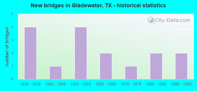
- New bridges - historical statistics
- 41930-1939
- 11940-1949
- 41950-1959
- 21960-1969
- 11970-1979
- 21980-1989
- 21990-1999

- Reconstructed bridges - Historical Statistics
- 11940-1949
- 21950-1959
- 11960-1969
- 01970-1979
- 01980-1989
- 01990-1999
- 12000-2009


- Bridge Condition - Deck
- 14.3%Very good
- 42.9%Good
- 28.6%Satisfactory
- 14.3%Fair

- Bridge Condition - Superstructure
- 28.6%Very good
- 28.6%Good
- 28.6%Satisfactory
- 14.3%Fair

- Bridge Condition - Substructure
- 71.4%Good
- 14.3%Satisfactory
- 14.3%Fair

- Bridge Condition - Channel
- 13.3%Good
- 73.3%Satisfactory
- 13.3%Fair

- Bridge Condition - Culverts
- 44.4%Good
- 33.3%Satisfactory
- 22.2%Fair
Find on map >> Show street view
Structure Number: 100930009604055, Location: 0.45 MI E OF SL 485 (Lat: 32.532222, Lng: -94.919703), Route carried "on" structure: US 80, Year Built: 1938, Year Reconstructed: 1955, Status: Open, Structure Length: 3.66m (12.01ft), Average Daily Traffic: 14,201 (year 2020), Truck Traffic: 6%, Average Future Daily Traffic: 21,360 (year 2033), Design Load: H 15, Features Intersected: MOODY CREEK
Minimum Vertical Clearance: 30+ m (98+ ft), Kilometerpoint: 3.985, Lanes on structure: 5, Owner: State Highway Agency, Approaching Roadway Width: 21.9m (71.9ft), Material/Design: Steel, Design/Construction: Stringer/Multi-beam, Number Of Spans In Main Unit: 3, Length of Maximum Span: 12.2m (40.0ft), Curb-To-Curb Width: 21.9m (71.9ft), Out-to-Out Width: 22.6m (74.1ft)
Condition: Deck: Satisfactory, Superstructure: Fair, Substructure: Fair, Channel: Satisfactory, Operating Rating: 43.5 metric tons, Method Used To Determine Operating Rating: Load Factor (LF), Inventory Rating: 26.3 metric tons, Method Used To Determine Inventory Rating: Load Factor (LF), Structural Evaluation: Somewhat better than minimum adequacy, Deck Geometry: Somewhat better than minimum adequacy, Waterway Adequacy: Equal to present minimum criteria, Approach Roadway Alignment: Equal to present desirable criteria, Designated Inspection Frequency: Every 24 months, Inspection Date: November 2020, Deck Structure Type: Concrete Cast-file-Place, Wearing Surface/Protective System: Wearing Surface: Bituminous
Find on map >> Show street view
Structure Number: 100930016503028, Location: 2.15 MI SW OF US 80 (Lat: 32.521283, Lng: -94.974261), Route carried "on" structure: US 271, Year Built: 1942, Year Reconstructed: 1960, Status: Open, Structure Length: 0.76m (2.49ft), Average Daily Traffic: 6,547 (year 2020), Truck Traffic: 17%, Average Future Daily Traffic: 9,700 (year 2033), Features Intersected: CARTER CREEK
Minimum Vertical Clearance: 30+ m (98+ ft), Kilometerpoint: 3.458, Lanes on structure: 2, Owner: State Highway Agency, Approaching Roadway Width: 14.0m (45.9ft), Skew: 3 degrees, Material/Design: Concrete, Design/Construction: Culvert, Number Of Spans In Main Unit: 2, Length of Maximum Span: 3.0m (9.8ft)
Condition: Channel: Satisfactory, Culverts: Satisfactory, Operating Rating: 32.7 metric tons, Method Used To Determine Operating Rating: Field evaluation and documented engineering judgment, Inventory Rating: 24.5 metric tons, Method Used To Determine Inventory Rating: Field evaluation and documented engineering judgment, Structural Evaluation: Equal to present minimum criteria, Waterway Adequacy: Equal to present minimum criteria, Approach Roadway Alignment: Equal to present desirable criteria, Designated Inspection Frequency: Every 24 months, Inspection Date: November 2020
Find on map >> Show street view
Structure Number: 100930016503029, Location: 1.20 MI SW OF US 80 (Lat: 32.526331, Lng: -94.962650), Route carried "on" structure: US 271, Year Built: 1956, Status: Open, Structure Length: 36.18m (118.70ft), Average Daily Traffic: 13,507 (year 2013), Truck Traffic: 18%, Average Future Daily Traffic: 18,000 (year 2033), Design Load: H 20, Features Intersected: SABINE RIVER
Minimum Vertical Clearance: 6.30m (20.67ft), Kilometerpoint: 1.880, Lanes on structure: 4, Owner: State Highway Agency, Approaching Roadway Width: 17.1m (56.1ft), Material/Design: Steel continuous, Design/Construction: Stringer/Multi-beam, Number Of Spans In Main Unit: 1, Number Of Approach Spans: 20, Length of Maximum Span: 37.2m (122.0ft), Curb or Sidewalk Widths: Left: 0.9m (3.0ft), Right: 0.9m (3.0ft), Curb-To-Curb Width: 17.2m (56.4ft), Out-to-Out Width: 19.4m (63.6ft)
Condition: Deck: Fair, Superstructure: Satisfactory, Substructure: Satisfactory, Channel: Satisfactory, Operating Rating: 33.6 metric tons, Method Used To Determine Operating Rating: Load Factor (LF), Inventory Rating: 20.0 metric tons, Method Used To Determine Inventory Rating: Load Factor (LF), Structural Evaluation: Somewhat better than minimum adequacy, Deck Geometry: Somewhat better than minimum adequacy, Waterway Adequacy: Equal to present desirable criteria, Approach Roadway Alignment: Equal to present desirable criteria, Length Of Structure Improvement: 36.18m (118.70ft), Designated Inspection Frequency: Every 24 months, Inspection Date: November 2020, Bridge Improvement Cost: $3,402,000, Roadway Improvement Cost: $93,000, Total Project Cost: $3,495,000, Deck Structure Type: Concrete Cast-file-Place
Find on map >> Show street view
Structure Number: 100930037701015, Location: 1.40 MI S OF US 271 (Lat: 32.504378, Lng: -94.964600), Route carried "on" structure: State highway 135, Year Built: 1938, Status: Open, Structure Length: 1.01m (3.31ft), Average Daily Traffic: 4,649 (year 2020), Truck Traffic: 11%, Average Future Daily Traffic: 8,180 (year 2033), Features Intersected: DRAW
Minimum Vertical Clearance: 30+ m (98+ ft), Kilometerpoint: 18.395, Lanes on structure: 2, Owner: State Highway Agency, Approaching Roadway Width: 7.3m (24.0ft), Material/Design: Concrete, Design/Construction: Culvert, Number Of Spans In Main Unit: 5, Length of Maximum Span: 1.8m (5.9ft)
Condition: Channel: Satisfactory, Culverts: Satisfactory, Operating Rating: 32.7 metric tons, Method Used To Determine Operating Rating: Field evaluation and documented engineering judgment, Inventory Rating: 24.5 metric tons, Method Used To Determine Inventory Rating: Field evaluation and documented engineering judgment, Structural Evaluation: Equal to present minimum criteria, Waterway Adequacy: Equal to present minimum criteria, Approach Roadway Alignment: Equal to present desirable criteria, Length Of Structure Improvement: 1.01m (3.31ft), Designated Inspection Frequency: Every 24 months, Inspection Date: November 2020, Bridge Improvement Cost: $2,000, Roadway Improvement Cost: $1,000, Total Project Cost: $3,000
Find on map >> Show street view
Structure Number: 100930329002001, Location: 0.40 MI S OF US 80 (Lat: 32.527750, Lng: -94.930617), Route carried "on" structure: Bypass State highway 485, Year Built: 1981, Status: Open, Structure Length: 4.42m (14.50ft), Average Daily Traffic: 5,469 (year 2018), Truck Traffic: 7%, Average Future Daily Traffic: 9,330 (year 2033), Design Load: HS 20, Features Intersected: UPRR
Minimum Vertical Clearance: 30+ m (98+ ft), Kilometerpoint: 9.119, Lanes on structure: 2, Owner: State Highway Agency, Approaching Roadway Width: 11.6m (38.1ft), Skew: 1 degrees, Material/Design: Prestressed concrete, Design/Construction: Stringer/Multi-beam, Number Of Spans In Main Unit: 2, Number Of Approach Spans: 1, Length of Maximum Span: 16.8m (55.1ft), Curb-To-Curb Width: 12.3m (40.4ft), Out-to-Out Width: 12.9m (42.3ft)
Condition: Deck: Good, Superstructure: Very good, Substructure: Good, Operating Rating: 54.4 metric tons, Method Used To Determine Operating Rating: Assigned rating based on Load Factor Design (LFD) reported in metric tons, Inventory Rating: 32.7 metric tons, Method Used To Determine Inventory Rating: Assigned rating based on Load Factor Design (LFD) reported in metric tons, Structural Evaluation: Better than present minimum criteria, Deck Geometry: Somewhat better than minimum adequacy, Underclear: Better than present minimum criteria, Approach Roadway Alignment: Equal to present desirable criteria, Designated Inspection Frequency: Every 24 months, Inspection Date: November 2020, Deck Structure Type: Concrete Precast Panels
Find on map >> Show street view
Structure Number: 100930AA0095001, Location: 0.4 MI E OF US HWY 271 (Lat: 32.516017, Lng: -94.977353), Route carried "on" structure: County highway , Year Built: 1996, Status: Open, Structure Length: 1.03m (3.38ft), Average Daily Traffic: 110 (year 2010), Average Future Daily Traffic: 200 (year 2030), Design Load: HS 20, Features Intersected: CARTER CR, Facility Carried by Structure: MCCOMIC RD
Minimum Vertical Clearance: 30+ m (98+ ft), Kilometerpoint: 0.644, Lanes on structure: 2, Owner: County Highway Agency, Approaching Roadway Width: 7.3m (24.0ft), Skew: 1 degrees, Material/Design: Concrete, Design/Construction: Culvert, Number Of Spans In Main Unit: 3, Length of Maximum Span: 3.1m (10.2ft), Curb-To-Curb Width: 7.2m (23.6ft), Out-to-Out Width: 8.0m (26.2ft)
Condition: Channel: Satisfactory, Culverts: Good, Operating Rating: 39.9 metric tons, Method Used To Determine Operating Rating: Load Factor (LF), Inventory Rating: 23.6 metric tons, Method Used To Determine Inventory Rating: Load Factor (LF), Structural Evaluation: Equal to present minimum criteria, Deck Geometry: Meets minimum limits, Waterway Adequacy: Better than present minimum criteria, Approach Roadway Alignment: Equal to present desirable criteria, Length Of Structure Improvement: 2.16m (7.09ft), Designated Inspection Frequency: Every 24 months, Inspection Date: March 2020, Bridge Improvement Cost: $32,000, Roadway Improvement Cost: $36,000, Total Project Cost: $68,000, Deck Structure Type: Concrete Cast-file-Place, Wearing Surface/Protective System: Wearing Surface: Bituminous
Find on map >> Show street view
Structure Number: 100930F00930001, Location: 0.7 MI SW OF FM 2275 (Lat: 32.542233, Lng: -94.919308), Route carried "on" structure: City street , Year Built: 1985, Status: Open, Structure Length: 3.66m (12.01ft), Average Daily Traffic: 860 (year 2010), Truck Traffic: 1%, Average Future Daily Traffic: 1,000 (year 2030), Design Load: HS 20, Features Intersected: MOODY CR, Facility Carried by Structure: SHELL CAMP RD
Minimum Vertical Clearance: 30+ m (98+ ft), Kilometerpoint: 1.127, Lanes on structure: 2, Owner: City or Municipal Highway Agency, Approaching Roadway Width: 6.7m (22.0ft), Material/Design: Prestressed concrete, Design/Construction: Box Beam or Girders - Multiple, Number Of Spans In Main Unit: 3, Length of Maximum Span: 12.2m (40.0ft), Curb-To-Curb Width: 10.1m (33.1ft), Out-to-Out Width: 11.1m (36.4ft)
Condition: Deck: Very good, Superstructure: Very good, Substructure: Good, Channel: Fair, Operating Rating: 54.4 metric tons, Method Used To Determine Operating Rating: Assigned rating based on Load Factor Design (LFD) reported in metric tons, Inventory Rating: 32.7 metric tons, Method Used To Determine Inventory Rating: Assigned rating based on Load Factor Design (LFD) reported in metric tons, Structural Evaluation: Better than present minimum criteria, Deck Geometry: Equal to present minimum criteria, Waterway Adequacy: Equal to present minimum criteria, Approach Roadway Alignment: Equal to present desirable criteria, Designated Inspection Frequency: Every 24 months, Inspection Date: March 2020, Deck Structure Type: Concrete Cast-file-Place, Wearing Surface/Protective System: Wearing Surface: Bituminous
Find on map >> Show street view
Structure Number: 100930F00935001, Location: 0.56 MI E OF US 80 (Lat: 32.534119, Lng: -94.919969), Route carried "on" structure: City street , Year Built: 1996, Status: Open, Structure Length: 3.15m (10.33ft), Average Daily Traffic: 420 (year 2010), Average Future Daily Traffic: 600 (year 2030), Design Load: HS 20, Features Intersected: MOODY CR, Facility Carried by Structure: ARMSTRONG RD
Minimum Vertical Clearance: 30+ m (98+ ft), Kilometerpoint: 0.901, Lanes on structure: 2, Owner: City or Municipal Highway Agency, Approaching Roadway Width: 6.7m (22.0ft), Skew: 1 degrees, Material/Design: Concrete, Design/Construction: Stringer/Multi-beam, Number Of Spans In Main Unit: 3, Length of Maximum Span: 12.4m (40.7ft), Curb-To-Curb Width: 9.1m (29.9ft), Out-to-Out Width: 9.8m (32.2ft)
Condition: Deck: Good, Superstructure: Good, Substructure: Good, Channel: Good, Operating Rating: 68.0 metric tons, Method Used To Determine Operating Rating: Load Factor (LF), Inventory Rating: 40.8 metric tons, Method Used To Determine Inventory Rating: Load Factor (LF), Structural Evaluation: Better than present minimum criteria, Deck Geometry: Equal to present minimum criteria, Waterway Adequacy: Superior to present desirable criteria, Approach Roadway Alignment: Equal to present desirable criteria, Length Of Structure Improvement: 3.75m (12.30ft), Designated Inspection Frequency: Every 24 months, Inspection Date: March 2020, Bridge Improvement Cost: $53,000, Roadway Improvement Cost: $53,000, Total Project Cost: $106,000, Deck Structure Type: Concrete Cast-file-Place
Find on map >> Show street view
Structure Number: 192300009603015, Location: 2.60 MI NW OF FM 2685 (Lat: 32.559656, Lng: -95.015653), Route carried "on" structure: US 80, Year Built: 1933, Year Reconstructed: 1954, Status: Open, Structure Length: 1.37m (4.49ft), Average Daily Traffic: 4,915 (year 2020), Truck Traffic: 7%, Average Future Daily Traffic: 7,280 (year 2033), Features Intersected: ROCKY CREEK
Minimum Vertical Clearance: 30+ m (98+ ft), Kilometerpoint: 14.938, Lanes on structure: 2, Owner: State Highway Agency, Approaching Roadway Width: 13.4m (44.0ft), Material/Design: Concrete, Design/Construction: Culvert, Number Of Spans In Main Unit: 4, Length of Maximum Span: 3.0m (9.8ft), Curb-To-Curb Width: 13.4m (44.0ft), Out-to-Out Width: 13.8m (45.3ft)
Condition: Channel: Satisfactory, Culverts: Satisfactory, Operating Rating: 32.7 metric tons, Method Used To Determine Operating Rating: Field evaluation and documented engineering judgment, Inventory Rating: 24.5 metric tons, Method Used To Determine Inventory Rating: Field evaluation and documented engineering judgment, Structural Evaluation: Equal to present minimum criteria, Deck Geometry: Better than present minimum criteria, Waterway Adequacy: Equal to present minimum criteria, Approach Roadway Alignment: Equal to present desirable criteria, Designated Inspection Frequency: Every 24 months, Inspection Date: July 2021, Deck Structure Type: Concrete Cast-file-Place, Wearing Surface/Protective System: Wearing Surface: Bituminous
Find on map >> Show street view
Structure Number: 192300009603016, Location: 0.40 MI NW OF FM 2685 (Lat: 32.549244, Lng: -94.981444), Route carried "on" structure: US 80, Year Built: 1933, Year Reconstructed: 1959, Status: Open, Structure Length: 0.67m (2.20ft), Average Daily Traffic: 5,840 (year 2020), Truck Traffic: 13%, Average Future Daily Traffic: 7,720 (year 2033), Features Intersected: GLADE BRANCH
Minimum Vertical Clearance: 30+ m (98+ ft), Kilometerpoint: 18.355, Lanes on structure: 2, Owner: State Highway Agency, Approaching Roadway Width: 13.4m (44.0ft), Material/Design: Concrete, Design/Construction: Culvert, Number Of Spans In Main Unit: 2, Length of Maximum Span: 3.0m (9.8ft), Curb-To-Curb Width: 14.1m (46.3ft), Out-to-Out Width: 16.2m (53.1ft)
Condition: Channel: Good, Culverts: Fair, Operating Rating: 32.7 metric tons, Method Used To Determine Operating Rating: Field evaluation and documented engineering judgment, Inventory Rating: 24.5 metric tons, Method Used To Determine Inventory Rating: Field evaluation and documented engineering judgment, Structural Evaluation: Somewhat better than minimum adequacy, Deck Geometry: Superior to present desirable criteria, Waterway Adequacy: Equal to present minimum criteria, Approach Roadway Alignment: Equal to present desirable criteria, Designated Inspection Frequency: Every 24 months, Inspection Date: July 2021, Deck Structure Type: Concrete Cast-file-Place, Wearing Surface/Protective System: Wearing Surface: Bituminous
Find on map >> Show street view
Structure Number: 192300138601001, Location: 1.55 MI W OF FM 2685 (Lat: 32.607467, Lng: -94.998814), Route carried "on" structure: State highway 1404, Year Built: 1958, Status: Open, Structure Length: 0.91m (2.99ft), Average Daily Traffic: 798 (year 2020), Truck Traffic: 14%, Average Future Daily Traffic: 1,440 (year 2033), Design Load: H 20, Features Intersected: DRAW
Minimum Vertical Clearance: 30+ m (98+ ft), Kilometerpoint: 8.164, Lanes on structure: 2, Owner: State Highway Agency, Approaching Roadway Width: 7.6m (24.9ft), Material/Design: Concrete, Design/Construction: Culvert, Number Of Spans In Main Unit: 4, Length of Maximum Span: 2.1m (6.9ft)
Condition: Channel: Satisfactory, Culverts: Good, Operating Rating: 39.9 metric tons, Method Used To Determine Operating Rating: Load Factor (LF), Inventory Rating: 23.6 metric tons, Method Used To Determine Inventory Rating: Load Factor (LF), Structural Evaluation: Equal to present minimum criteria, Waterway Adequacy: Equal to present minimum criteria, Approach Roadway Alignment: Equal to present desirable criteria, Designated Inspection Frequency: Every 24 months, Inspection Date: July 2021
Find on map >> Show street view
Structure Number: 192300138601002, Location: 0.05 MI NW OF FM 2685 (Lat: 32.606108, Lng: -94.972808), Route carried "on" structure: State highway 1404, Year Built: 1958, Status: Open, Structure Length: 0.76m (2.49ft), Average Daily Traffic: 798 (year 2020), Truck Traffic: 14%, Average Future Daily Traffic: 1,440 (year 2033), Design Load: H 20, Features Intersected: DRAW
Minimum Vertical Clearance: 30+ m (98+ ft), Kilometerpoint: 10.651, Lanes on structure: 2, Owner: State Highway Agency, Approaching Roadway Width: 7.3m (24.0ft), Material/Design: Concrete, Design/Construction: Culvert, Number Of Spans In Main Unit: 3, Length of Maximum Span: 2.4m (7.9ft)
Condition: Channel: Satisfactory, Culverts: Good, Operating Rating: 39.9 metric tons, Method Used To Determine Operating Rating: Load Factor (LF), Inventory Rating: 23.6 metric tons, Method Used To Determine Inventory Rating: Load Factor (LF), Structural Evaluation: Equal to present minimum criteria, Waterway Adequacy: Equal to present minimum criteria, Approach Roadway Alignment: Equal to present desirable criteria, Designated Inspection Frequency: Every 24 months, Inspection Date: July 2021
Find on map >> Show street view
Structure Number: 192300215701001, Location: 0.60 MI S OF FM 1404 (Lat: 32.596983, Lng: -94.970639), Route carried "on" structure: State highway 2685, Year Built: 1958, Status: Open, Structure Length: 0.79m (2.59ft), Average Daily Traffic: 1,985 (year 2020), Truck Traffic: 8%, Average Future Daily Traffic: 3,280 (year 2033), Design Load: H 20, Features Intersected: SAND SPRING BRANCH
Minimum Vertical Clearance: 30+ m (98+ ft), Kilometerpoint: 11.644, Lanes on structure: 2, Owner: State Highway Agency, Approaching Roadway Width: 7.3m (24.0ft), Material/Design: Concrete, Design/Construction: Culvert, Number Of Spans In Main Unit: 3, Length of Maximum Span: 2.4m (7.9ft)
Condition: Channel: Fair, Culverts: Fair, Operating Rating: 39.9 metric tons, Method Used To Determine Operating Rating: Load Factor (LF), Inventory Rating: 23.6 metric tons, Method Used To Determine Inventory Rating: Load Factor (LF), Structural Evaluation: Somewhat better than minimum adequacy, Waterway Adequacy: Equal to present minimum criteria, Approach Roadway Alignment: Equal to present desirable criteria, Designated Inspection Frequency: Every 24 months, Inspection Date: July 2021
Find on map >> Show street view
Structure Number: 192300215701002, Location: 1.25 MI N OF FM 1404 (Lat: 32.623878, Lng: -94.969536), Route carried "on" structure: State highway 2685, Year Built: 1963, Year Reconstructed: 2009, Status: Open, Structure Length: 4.63m (15.19ft), Average Daily Traffic: 805 (year 2020), Truck Traffic: 14%, Average Future Daily Traffic: 1,160 (year 2033), Design Load: H 15, Features Intersected: GLADE CREEK
Minimum Vertical Clearance: 30+ m (98+ ft), Kilometerpoint: 8.464, Lanes on structure: 2, Owner: State Highway Agency, Approaching Roadway Width: 7.3m (24.0ft), Material/Design: Concrete, Design/Construction: Stringer/Multi-beam, Number Of Spans In Main Unit: 5, Length of Maximum Span: 9.1m (29.9ft), Curb-To-Curb Width: 13.1m (43.0ft), Out-to-Out Width: 14.0m (45.9ft)
Condition: Deck: Good, Superstructure: Satisfactory, Substructure: Good, Channel: Satisfactory, Operating Rating: 55.3 metric tons, Method Used To Determine Operating Rating: Load Factor (LF), Inventory Rating: 32.7 metric tons, Method Used To Determine Inventory Rating: Load Factor (LF), Structural Evaluation: Equal to present minimum criteria, Deck Geometry: Superior to present desirable criteria, Waterway Adequacy: Better than present minimum criteria, Approach Roadway Alignment: Equal to present desirable criteria, Designated Inspection Frequency: Every 24 months, Inspection Date: July 2021, Deck Structure Type: Concrete Cast-file-Place, Wearing Surface/Protective System: Wearing Surface: Bituminous
Find on map >> Show street view
Structure Number: 192300215701003, Location: 0.15 MI N OF FM 1404 (Lat: 32.607911, Lng: -94.972164), Route carried "on" structure: State highway 2685, Year Built: 1963, Status: Open, Structure Length: 1.07m (3.51ft), Average Daily Traffic: 805 (year 2020), Truck Traffic: 14%, Average Future Daily Traffic: 1,160 (year 2033), Design Load: HS 20, Features Intersected: MITCHELL BRANCH
Minimum Vertical Clearance: 30+ m (98+ ft), Kilometerpoint: 10.298, Lanes on structure: 2, Owner: State Highway Agency, Approaching Roadway Width: 7.3m (24.0ft), Material/Design: Concrete, Design/Construction: Culvert, Number Of Spans In Main Unit: 4, Length of Maximum Span: 2.4m (7.9ft)
Condition: Channel: Satisfactory, Culverts: Good, Operating Rating: 39.9 metric tons, Method Used To Determine Operating Rating: Load Factor (LF), Inventory Rating: 23.6 metric tons, Method Used To Determine Inventory Rating: Load Factor (LF), Structural Evaluation: Equal to present minimum criteria, Waterway Adequacy: Better than present minimum criteria, Approach Roadway Alignment: Equal to present desirable criteria, Designated Inspection Frequency: Every 24 months, Inspection Date: July 2021
Find on map >> Show street view
Structure Number: 192300F00025001, Location: 1.3 MI E OF FM 2685 (Lat: 32.545900, Lng: -94.956711), Route carried "on" structure: City street 200, Year Built: 1976, Status: Open, Structure Length: 4.63m (15.19ft), Average Daily Traffic: 3,558 (year 2018), Average Future Daily Traffic: 408 (year 2033), Design Load: HS 20, Features Intersected: GLADE CREEK, Facility Carried by Structure: GAY AVE
Minimum Vertical Clearance: 30+ m (98+ ft), Kilometerpoint: 1.931, Lanes on structure: 2, Owner: City or Municipal Highway Agency, Approaching Roadway Width: 9.8m (32.2ft), Material/Design: Concrete, Design/Construction: Stringer/Multi-beam, Number Of Spans In Main Unit: 5, Length of Maximum Span: 9.1m (29.9ft), Curb-To-Curb Width: 14.7m (48.2ft), Out-to-Out Width: 15.3m (50.2ft)
Condition: Deck: Satisfactory, Superstructure: Good, Substructure: Good, Channel: Satisfactory, Operating Rating: 54.4 metric tons, Method Used To Determine Operating Rating: Load Factor (LF), Inventory Rating: 32.7 metric tons, Method Used To Determine Inventory Rating: Load Factor (LF), Structural Evaluation: Better than present minimum criteria, Deck Geometry: Superior to present desirable criteria, Waterway Adequacy: Equal to present minimum criteria, Approach Roadway Alignment: Equal to present desirable criteria, Designated Inspection Frequency: Every 24 months, Inspection Date: May 2020, Deck Structure Type: Concrete Cast-file-Place