Bridge Statistics for Gilberts, Illinois (IL)
Condition, Traffic, Stress, Structural Evaluation, Project Costs
- National Bridge Inventory (NBI) Statistics
- 10Number of bridges
- 112ft / 33.7mTotal length
- $128,000Total costs
- 227,450Total average daily traffic
- 32,779Total average daily truck traffic
- National Bridge Inventory (NBI) Registered Bridges for Gilberts
- No street view available for this location
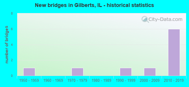
- New bridges - historical statistics
- 11950-1959
- 11970-1979
- 11990-1999
- 12000-2009
- 62010-2019


- Bridge Condition - Deck
- 50.0%Very good
- 33.3%Good
- 16.7%Fair

- Bridge Condition - Superstructure
- 66.7%Very good
- 16.7%Good
- 16.7%Fair

- Bridge Condition - Substructure
- 50.0%Very good
- 33.3%Good
- 16.7%Fair

- Bridge Condition - Channel
- 25.0%Very good
- 25.0%Good
- 50.0%Fair

- Bridge Condition - Culverts
- 50.0%Good
- 50.0%Satisfactory
Find on map >> Show street view
Structure Number: 453063, Location: 0.7 MI N BIG TIMBER (Lat: 42.089767, Lng: -88.379836), Route carried "on" structure: County highway , Year Built: 1959, Year Reconstructed: 2005, Status: Open, Structure Length: 1.86m (6.10ft), Average Daily Traffic: 375 (year 2018), Truck Traffic: 6%, Average Future Daily Traffic: 191 (year 2032), Design Load: HS 15, Features Intersected: TYLER CREEK, Facility Carried by Structure: MC CORNACK ROAD
Minimum Vertical Clearance: 30+ m (98+ ft), Kilometerpoint: 1.320, Lanes on structure: 2, Owner: Town or Township Highway Agency, Approaching Roadway Width: 6.1m (20.0ft), Material/Design: Prestressed concrete, Design/Construction: Box Beam or Girders - Multiple, Number Of Spans In Main Unit: 2, Length of Maximum Span: 8.7m (28.5ft), Curb-To-Curb Width: 7.9m (25.9ft), Out-to-Out Width: 7.9m (25.9ft)
Condition: Deck: Fair, Superstructure: Fair, Substructure: Fair, Channel: Fair, Operating Rating: 76.5 metric tons, Method Used To Determine Operating Rating: Load Factor (LF) rating reported by rating factor (RF) method using MS18 loading, Inventory Rating: 46.0 metric tons, Method Used To Determine Inventory Rating: Load Factor (LF) rating reported by rating factor (RF) method using MS18 loading, Structural Evaluation: Somewhat better than minimum adequacy, Deck Geometry: Somewhat better than minimum adequacy, Waterway Adequacy: Better than present minimum criteria, Approach Roadway Alignment: Equal to present minimum criteria, Length Of Structure Improvement: 1.86m (6.10ft), Designated Inspection Frequency: Every 24 months, Inspection Date: May 2021, Bridge Improvement Cost: $85,000, Roadway Improvement Cost: $9,000, Total Project Cost: $128,000, Deck Structure Type: Concrete Precast Panels, Wearing Surface/Protective System: Wearing Surface: Bituminous, Membrane: Built-up
Find on map >> Show street view
Structure Number: 453157, Location: 1.25M W. RANDALL RD (Lat: 42.072519, Lng: -88.357289), Route carried "on" structure: Other road , Year Built: 2003, Status: Open, Structure Length: 2.36m (7.74ft), Average Daily Traffic: 13,900 (year 2018), Truck Traffic: 3%, Average Future Daily Traffic: 16,460 (year 2032), Design Load: HS 20, Features Intersected: TYLER CR., Facility Carried by Structure: BIG TIMBER RD
Minimum Vertical Clearance: 30+ m (98+ ft), Kilometerpoint: 4.796, Lanes on structure: 2, Base Highway Network: Yes, Owner: County Highway Agency, Approaching Roadway Width: 19.5m (64.0ft), Skew: 1 degrees, Material/Design: Prestressed concrete, Design/Construction: Box Beam or Girders - Multiple, Number Of Spans In Main Unit: 1, Length of Maximum Span: 22.5m (73.8ft), Curb-To-Curb Width: 19.5m (64.0ft), Out-to-Out Width: 21.0m (68.9ft)
Condition: Deck: Good, Superstructure: Good, Substructure: Very good, Channel: Very good, Operating Rating: 57.0 metric tons, Method Used To Determine Operating Rating: Load Factor (LF) rating reported by rating factor (RF) method using MS18 loading, Inventory Rating: 29.5 metric tons, Method Used To Determine Inventory Rating: Load Factor (LF) rating reported by rating factor (RF) method using MS18 loading, Structural Evaluation: Better than present minimum criteria, Deck Geometry: Superior to present desirable criteria, Waterway Adequacy: Equal to present desirable criteria, Approach Roadway Alignment: Equal to present desirable criteria, Designated Inspection Frequency: Every 48 months, Inspection Date: January 2018, Deck Structure Type: Concrete Precast Panels, Wearing Surface/Protective System: Wearing Surface: Integral Concrete, Deck Protection: Epoxy Coated Reinforcing
Find on map >> Show street view
Structure Number: 456303, Location: W OF TIPPERARY ST (Lat: 42.080353, Lng: -88.357672), Route carried "on" structure: City street , Year Built: 1975, Year Reconstructed: 2009, Status: Open, Structure Length: 1.77m (5.81ft), Average Daily Traffic: 25 (year 2012), Average Future Daily Traffic: 200 (year 2032), Features Intersected: TYLER CREEK, Facility Carried by Structure: HENNESSY COURT
Minimum Vertical Clearance: 30+ m (98+ ft), Kilometerpoint: 0.193, Lanes on structure: 2, Owner: City or Municipal Highway Agency, Approaching Roadway Width: 7.0m (23.0ft), Material/Design: Steel, Design/Construction: Culvert, Number Of Spans In Main Unit: 7, Length of Maximum Span: 2.1m (6.9ft), Curb-To-Curb Width: 9.8m (32.2ft)
Condition: Channel: Good, Culverts: Good, Operating Rating: 53.8 metric tons, Method Used To Determine Operating Rating: Load Factor (LF) rating reported by rating factor (RF) method using MS18 loading, Inventory Rating: 32.4 metric tons, Method Used To Determine Inventory Rating: Load Factor (LF) rating reported by rating factor (RF) method using MS18 loading, Structural Evaluation: Better than present minimum criteria, Deck Geometry: Equal to present desirable criteria, Waterway Adequacy: Equal to present desirable criteria, Approach Roadway Alignment: Equal to present desirable criteria, Designated Inspection Frequency: Every 24 months, Inspection Date: August 2021
Find on map >> Show street view
Structure Number: 456311, Location: E OF EAST END DRIVE (Lat: 42.100486, Lng: -88.365489), Route carried "on" structure: City street , Year Built: 1990, Status: Open, Structure Length: 0.68m (2.23ft), Average Daily Traffic: 550 (year 2018), Truck Traffic: 31%, Average Future Daily Traffic: 383 (year 2032), Features Intersected: TYLER CREEK TRIB, Facility Carried by Structure: SOLA DRIVE
Minimum Vertical Clearance: 30+ m (98+ ft), Kilometerpoint: 0.386, Lanes on structure: 2, Owner: City or Municipal Highway Agency, Approaching Roadway Width: 8.8m (28.9ft), Skew: 1 degrees, Material/Design: Steel, Design/Construction: Culvert, Number Of Spans In Main Unit: 4, Length of Maximum Span: 1.6m (5.2ft)
Condition: Channel: Fair, Culverts: Satisfactory, Operating Rating: 89.1 metric tons, Method Used To Determine Operating Rating: Load Factor (LF) rating reported by rating factor (RF) method using MS18 loading, Inventory Rating: 89.1 metric tons, Method Used To Determine Inventory Rating: Load Factor (LF) rating reported by rating factor (RF) method using MS18 loading, Structural Evaluation: Equal to present minimum criteria, Waterway Adequacy: Better than present minimum criteria, Approach Roadway Alignment: Equal to present desirable criteria, Designated Inspection Frequency: Every 24 months, Inspection Date: August 2021
Find on map >> Show street view
Structure Number: 459901, Location: 3.0 M E OF IL 47 (Lat: 42.100631, Lng: -88.381461), Route carried "on" structure: State highway 72, Year Built: 2015, Status: Open, Structure Length: 7.89m (25.89ft), Average Daily Traffic: 15,800 (year 2021), Truck Traffic: 11%, Average Future Daily Traffic: 20,416 (year 2032), Design Load: HS 25 or greater, Features Intersected: I- 90
Minimum Vertical Clearance: 30+ m (98+ ft), Kilometerpoint: 126.411, Lanes on structure: 2, Lanes under structure: 6, Base Highway Network: Yes, Toll: On toll road, Owner: State Highway Agency, Approaching Roadway Width: 17.1m (56.1ft), Skew: 3 degrees, Material/Design: Prestressed concrete continuous, Design/Construction: Stringer/Multi-beam, Number Of Spans In Main Unit: 2, Length of Maximum Span: 43.4m (142.4ft), Curb-To-Curb Width: 17.1m (56.1ft), Out-to-Out Width: 18.1m (59.4ft)
Condition: Deck: Good, Superstructure: Very good, Substructure: Very good, Operating Rating: 41.5 metric tons, Method Used To Determine Operating Rating: Load and Resistance Factor Rating (LRFR) rating reported by rating factor(RF) method using HL-93 loadings, Inventory Rating: 32.1 metric tons, Method Used To Determine Inventory Rating: Load and Resistance Factor Rating (LRFR) rating reported by rating factor(RF) method using HL-93 loadings, Structural Evaluation: Better than present minimum criteria, Deck Geometry: Superior to present desirable criteria, Underclear: Somewhat better than minimum adequacy, Approach Roadway Alignment: Equal to present desirable criteria, Designated Inspection Frequency: Every 24 months, Inspection Date: August 2020, Deck Structure Type: Concrete Cast-file-Place, Wearing Surface/Protective System: Deck Protection: Epoxy Coated Reinforcing
Find on map >> Show street view
Structure Number: 459904, Location: I90 .9 MI S OF IL72 (Lat: 42.091631, Lng: -88.359669), Route carried "on" structure: County highway , Year Built: 2015, Status: Open, Structure Length: 7.61m (24.97ft), Average Daily Traffic: 9,600 (year 2018), Truck Traffic: 5%, Average Future Daily Traffic: 12,760 (year 2038), Design Load: HS 25 or greater, Features Intersected: I-90 Jane Addams Tol, Facility Carried by Structure: Tyrrell Road
Minimum Vertical Clearance: 30+ m (98+ ft), Kilometerpoint: 1.239, Lanes on structure: 2, Lanes under structure: 6, Base Highway Network: Yes, Owner: County Highway Agency, Approaching Roadway Width: 12.2m (40.0ft), Skew: 3 degrees, Material/Design: Prestressed concrete, Design/Construction: Stringer/Multi-beam, Number Of Spans In Main Unit: 2, Length of Maximum Span: 41.1m (134.8ft), Curb-To-Curb Width: 12.2m (40.0ft), Out-to-Out Width: 13.2m (43.3ft)
Condition: Deck: Very good, Superstructure: Very good, Substructure: Very good, Operating Rating: 52.2 metric tons, Method Used To Determine Operating Rating: Load and Resistance Factor Rating (LRFR) rating reported by rating factor(RF) method using HL-93 loadings, Inventory Rating: 40.2 metric tons, Method Used To Determine Inventory Rating: Load and Resistance Factor Rating (LRFR) rating reported by rating factor(RF) method using HL-93 loadings, Structural Evaluation: Equal to present desirable criteria, Deck Geometry: Somewhat better than minimum adequacy, Underclear: Equal to present minimum criteria, Approach Roadway Alignment: Equal to present desirable criteria, Designated Inspection Frequency: Every 24 months, Inspection Date: August 2020, Deck Structure Type: Concrete Cast-file-Place, Wearing Surface/Protective System: Deck Protection: Epoxy Coated Reinforcing
Find on map >> Show street view
Structure Number: 459968, Location: 2 MI W RANDALL (Lat: 42.095953, Lng: -88.370425), Route carried "on" structure: Interstate 90, Year Built: 2014, Status: Open, Structure Length: 5.76m (18.90ft), Average Daily Traffic: 31,200 (year 2020), Truck Traffic: 16%, Average Future Daily Traffic: 52,700 (year 2032), Design Load: HS 25 or greater, Features Intersected: UP RR
Minimum Vertical Clearance: 30+ m (98+ ft), Kilometerpoint: 80.626, Lanes on structure: 3, Base Highway Network: Yes, Toll: On toll road, Owner: State Toll Authority, Approaching Roadway Width: 20.1m (65.9ft), Skew: 4 degrees, Material/Design: Steel, Design/Construction: Stringer/Multi-beam, Number Of Spans In Main Unit: 1, Length of Maximum Span: 56.2m (184.4ft), Curb-To-Curb Width: 20.1m (65.9ft), Out-to-Out Width: 21.0m (68.9ft)
Condition: Deck: Very good, Superstructure: Very good, Substructure: Good, Operating Rating: 62.5 metric tons, Method Used To Determine Operating Rating: Load and Resistance Factor Rating (LRFR) rating reported by rating factor(RF) method using HL-93 loadings, Inventory Rating: 48.3 metric tons, Method Used To Determine Inventory Rating: Load and Resistance Factor Rating (LRFR) rating reported by rating factor(RF) method using HL-93 loadings, Structural Evaluation: Better than present minimum criteria, Deck Geometry: Superior to present desirable criteria, Underclear: Superior to present desirable criteria, Approach Roadway Alignment: Equal to present desirable criteria, Designated Inspection Frequency: Every 24 months, Inspection Date: August 2020, Deck Structure Type: Concrete Cast-file-Place, Wearing Surface/Protective System: Deck Protection: Epoxy Coated Reinforcing
Find on map >> Show street view
Structure Number: 459969, Location: 2 MI W RANDALL RD (Lat: 42.096028, Lng: -88.370592), Route carried "on" structure: Interstate 90, Year Built: 2013, Status: Open, Structure Length: 5.76m (18.90ft), Average Daily Traffic: 31,200 (year 2020), Truck Traffic: 16%, Average Future Daily Traffic: 52,700 (year 2032), Design Load: HS 25 or greater, Features Intersected: UP RR
Minimum Vertical Clearance: 30+ m (98+ ft), Kilometerpoint: 80.610, Lanes on structure: 3, Base Highway Network: Yes, Toll: On toll road, Owner: State Toll Authority, Approaching Roadway Width: 20.1m (65.9ft), Skew: 4 degrees, Material/Design: Steel, Design/Construction: Stringer/Multi-beam, Number Of Spans In Main Unit: 1, Length of Maximum Span: 56.2m (184.4ft), Curb-To-Curb Width: 20.1m (65.9ft), Out-to-Out Width: 21.0m (68.9ft)
Condition: Deck: Very good, Superstructure: Very good, Substructure: Good, Operating Rating: 62.5 metric tons, Method Used To Determine Operating Rating: Load and Resistance Factor Rating (LRFR) rating reported by rating factor(RF) method using HL-93 loadings, Inventory Rating: 48.3 metric tons, Method Used To Determine Inventory Rating: Load and Resistance Factor Rating (LRFR) rating reported by rating factor(RF) method using HL-93 loadings, Structural Evaluation: Better than present minimum criteria, Deck Geometry: Superior to present desirable criteria, Underclear: Superior to present desirable criteria, Approach Roadway Alignment: Equal to present desirable criteria, Designated Inspection Frequency: Every 24 months, Inspection Date: August 2020, Deck Structure Type: Concrete Cast-file-Place, Wearing Surface/Protective System: Deck Protection: Epoxy Coated Reinforcing
Find on map >> Show street view
Structure Number: 459901, Location: 3.0 M E OF IL 47 (Lat: 42.100631, Lng: -88.381461), Route carried "under" structure: Interstate 90, Year Built: 2015, Structure Length: 0. m, Average Daily Traffic: 62,400 (year 2020), Truck Traffic: 16%, Features Intersected: I- 90, Facility Carried by Structure: IL 72
Minimum Vertical Clearance: 5.05m (16.57ft), Kilometerpoint: 79.580, Lanes on structure: 2, Lanes under structure: 6, Toll: On toll road, Material/Design: Prestressed concrete continuous, Design/Construction: Stringer/Multi-beam, Length of Maximum Span: 43.4m (142.4ft)
Find on map >> Show street view
Structure Number: 459904, Location: I90 .9 MI S OF IL72 (Lat: 42.091211, Lng: -88.359661), Route carried "under" structure: Interstate 90, Year Built: 2015, Structure Length: 0. m, Average Daily Traffic: 62,400 (year 2020), Truck Traffic: 16%, Features Intersected: I-90 Jane Addams Tol, Facility Carried by Structure: Tyrrell Road
Minimum Vertical Clearance: 5.03m (16.50ft), Kilometerpoint: 81.656, Lanes on structure: 2, Lanes under structure: 6, Material/Design: Prestressed concrete, Design/Construction: Stringer/Multi-beam, Length of Maximum Span: 41.1m (134.8ft)