Bridge Statistics for Gettysburg, Pennsylvania (PA)
Condition, Traffic, Stress, Structural Evaluation, Project Costs
- National Bridge Inventory (NBI) Statistics
- 25Number of bridges
- 157ft / 48.0mTotal length
- $2,387,000Total costs
- 143,692Total average daily traffic
- 19,235Total average daily truck traffic
- National Bridge Inventory (NBI) Registered Bridges for Gettysburg
- No street view available for this location
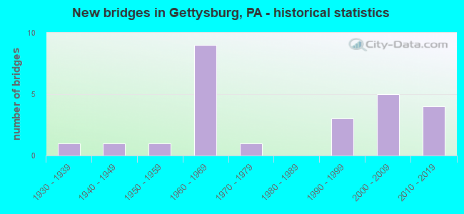
- New bridges - historical statistics
- 11930-1939
- 11940-1949
- 11950-1959
- 91960-1969
- 11970-1979
- 31990-1999
- 52000-2009
- 42010-2019


- Bridge Condition - Deck
- 6.3%Excellent
- 12.5%Very good
- 62.5%Good
- 6.3%Satisfactory
- 12.5%Fair

- Bridge Condition - Superstructure
- 31.3%Very good
- 43.8%Good
- 18.8%Satisfactory
- 6.3%Fair

- Bridge Condition - Substructure
- 12.5%Very good
- 50.0%Good
- 18.8%Satisfactory
- 18.8%Fair

- Bridge Condition - Channel
- 7.1%Very good
- 42.9%Good
- 14.3%Satisfactory
- 28.6%Fair
- 7.1%Poor
Find on map >> Show street view
Structure Number: 18, Location: 2 MI. N. OF GETTYSBURG (Lat: 39.851767, Lng: -77.196464), Route carried "on" structure: US 15, Year Built: 1990, Status: Open, Structure Length: 2.80m (9.19ft), Average Daily Traffic: 9,197 (year 2021), Truck Traffic: 20%, Average Future Daily Traffic: 11,775 (year 2032), Design Load: HS 25 or greater, Features Intersected: CSX
Minimum Vertical Clearance: 30+ m (98+ ft), Kilometerpoint: 19.158, Lanes on structure: 3, Base Highway Network: Yes, Owner: State Highway Agency, Approaching Roadway Width: 14.9m (48.9ft), Skew: 10 degrees, Material/Design: Prestressed concrete, Design/Construction: Stringer/Multi-beam, Number Of Spans In Main Unit: 1, Length of Maximum Span: 26.8m (87.9ft), Curb or Sidewalk Widths: Left: 0.2m (0.7ft), Right: 0.2m (0.7ft), Curb-To-Curb Width: 15.4m (50.5ft), Out-to-Out Width: 16.1m (52.8ft)
Condition: Deck: Good, Superstructure: Good, Substructure: Good, Inventory Rating: 40.8 metric tons, Method Used To Determine Inventory Rating: Load Factor (LF), Structural Evaluation: Better than present minimum criteria, Deck Geometry: Somewhat better than minimum adequacy, Underclear: High priority of corrective action, Approach Roadway Alignment: Equal to present desirable criteria, Length Of Structure Improvement: 3.60m (11.81ft), Designated Inspection Frequency: Every 24 months, Inspection Date: May 2021, Deck Structure Type: Concrete Cast-file-Place, Wearing Surface/Protective System: Wearing Surface: Monolithic Concrete, Deck Protection: Epoxy Coated Reinforcing
Find on map >> Show street view
Structure Number: 5, Location: E OF GETTYSBURG (Lat: 39.846233, Lng: -77.195156), Route carried "on" structure: US 30, Year Built: 1963, Status: Open, Structure Length: 3.99m (13.09ft), Average Daily Traffic: 14,729 (year 2020), Truck Traffic: 7%, Average Future Daily Traffic: 27,179 (year 2032), Design Load: HS 20, Features Intersected: US 15; SR 0015
Minimum Vertical Clearance: 30+ m (98+ ft), Kilometerpoint: 26.075, Lanes on structure: 4, Lanes under structure: 10, Base Highway Network: Yes, Owner: State Highway Agency, Approaching Roadway Width: 20.7m (67.9ft), Skew: 20 degrees, Material/Design: Prestressed concrete, Design/Construction: Box Beam or Girders - Single/Spread, Number Of Spans In Main Unit: 2, Length of Maximum Span: 19.5m (64.0ft), Curb or Sidewalk Widths: Left: 0.5m (1.6ft), Right: 0.5m (1.6ft), Curb-To-Curb Width: 20.7m (67.9ft), Out-to-Out Width: 22.4m (73.5ft)
Condition: Deck: Satisfactory, Superstructure: Satisfactory, Substructure: Fair, Operating Rating: 36.3 metric tons, Method Used To Determine Operating Rating: Load Factor (LF), Inventory Rating: 21.8 metric tons, Method Used To Determine Inventory Rating: Load Factor (LF), Structural Evaluation: Somewhat better than minimum adequacy, Deck Geometry: Superior to present desirable criteria, Underclear: High priority of corrective action, Approach Roadway Alignment: Equal to present desirable criteria, Length Of Structure Improvement: 4.00m (13.12ft), Designated Inspection Frequency: Every 24 months, Inspection Date: April 2021, Bridge Improvement Cost: $38,000, Roadway Improvement Cost: $111,000, Total Project Cost: $510,000, Deck Structure Type: Concrete Cast-file-Place, Wearing Surface/Protective System: Wearing Surface: Bituminous
Find on map >> Show street view
Structure Number: 101, Location: SW OF GETTYSBURG (Lat: 39.818367, Lng: -77.284661), Route carried "on" structure: State highway 116, Year Built: 1947, Year Reconstructed: 2012, Status: Open, Structure Length: 4.85m (15.91ft), Average Daily Traffic: 8,831 (year 2022), Truck Traffic: 5%, Average Future Daily Traffic: 13,220 (year 2032), Design Load: HL 93, Features Intersected: MARSH CREEK
Minimum Vertical Clearance: 30+ m (98+ ft), Kilometerpoint: 14.262, Lanes on structure: 2, Base Highway Network: Yes, Owner: State Highway Agency, Approaching Roadway Width: 9.4m (30.8ft), Material/Design: Steel, Design/Construction: Stringer/Multi-beam, Number Of Spans In Main Unit: 3, Length of Maximum Span: 16.2m (53.1ft), Curb-To-Curb Width: 9.2m (30.2ft), Out-to-Out Width: 10.7m (35.1ft)
Condition: Deck: Good, Superstructure: Good, Substructure: Good, Channel: Poor, Operating Rating: 61.7 metric tons, Method Used To Determine Operating Rating: Load and Resistance Factor (LRFR), Inventory Rating: 47.2 metric tons, Method Used To Determine Inventory Rating: Load and Resistance Factor (LRFR), Structural Evaluation: Better than present minimum criteria, Deck Geometry: High priority of corrective action, Waterway Adequacy: Equal to present minimum criteria, Approach Roadway Alignment: Equal to present desirable criteria, Length Of Structure Improvement: 5.90m (19.36ft), Designated Inspection Frequency: Every 24 months, Inspection Date: March 2021, Bridge Improvement Cost: $100,000, Roadway Improvement Cost: $293,000, Total Project Cost: $1,344,000, Deck Structure Type: Concrete Cast-file-Place, Wearing Surface/Protective System: Wearing Surface: Latex Concrete, Deck Protection: Epoxy Coated Reinforcing
Find on map >> Show street view
Structure Number: 12, Location: 4 MI. S. OF GETTYSBURG (Lat: 39.776756, Lng: -77.229239), Route carried "on" structure: State highway 134, Year Built: 1963, Year Reconstructed: 2011, Status: Open, Structure Length: 4.39m (14.40ft), Average Daily Traffic: 1,907 (year 2020), Truck Traffic: 7%, Average Future Daily Traffic: 3,035 (year 2032), Design Load: HS 20, Features Intersected: US 15; SR 0015
Minimum Vertical Clearance: 30+ m (98+ ft), Kilometerpoint: 6.703, Lanes on structure: 2, Lanes under structure: 8, Owner: State Highway Agency, Approaching Roadway Width: 12.2m (40.0ft), Skew: 2 degrees, Material/Design: Prestressed concrete, Design/Construction: Stringer/Multi-beam, Number Of Spans In Main Unit: 2, Length of Maximum Span: 21.0m (68.9ft), Curb or Sidewalk Widths: Left: 0.2m (0.7ft), Right: 0.2m (0.7ft), Curb-To-Curb Width: 11.7m (38.4ft), Out-to-Out Width: 12.8m (42.0ft)
Condition: Deck: Very good, Superstructure: Satisfactory, Substructure: Satisfactory, Operating Rating: 95.3 metric tons, Method Used To Determine Operating Rating: Load Factor (LF), Inventory Rating: 17.2 metric tons, Method Used To Determine Inventory Rating: Load Factor (LF), Structural Evaluation: Meets minimum limits, Deck Geometry: Equal to present minimum criteria, Underclear: High priority of corrective action, Approach Roadway Alignment: Equal to present desirable criteria, Length Of Structure Improvement: 4.40m (14.44ft), Designated Inspection Frequency: Every 24 months, Inspection Date: December 2020, Bridge Improvement Cost: $26,000, Roadway Improvement Cost: $77,000, Total Project Cost: $352,000, Deck Structure Type: Concrete Cast-file-Place, Wearing Surface/Protective System: Wearing Surface: Monolithic Concrete, Deck Protection: Epoxy Coated Reinforcing
Find on map >> Show street view
Structure Number: 295, Location: SOUTH OF GETTYSBURG (Lat: 39.765044, Lng: -77.258125), Route carried "on" structure: State highway , Year Built: 1990, Status: Open, Structure Length: 5.82m (19.09ft), Average Daily Traffic: 533 (year 2020), Truck Traffic: 3%, Average Future Daily Traffic: 568 (year 2032), Design Load: HS 25 or greater, Features Intersected: US 15 NB; SR 0015, Facility Carried by Structure: SR 3006; BARLOW RD
Minimum Vertical Clearance: 30+ m (98+ ft), Kilometerpoint: 0.584, Lanes on structure: 2, Lanes under structure: 2, Owner: State Highway Agency, Approaching Roadway Width: 9.1m (29.9ft), Skew: 3 degrees, Material/Design: Prestressed concrete, Design/Construction: Stringer/Multi-beam, Number Of Spans In Main Unit: 3, Length of Maximum Span: 32.0m (105.0ft), Curb or Sidewalk Widths: Left: 0.2m (0.7ft), Right: 0.2m (0.7ft), Curb-To-Curb Width: 8.9m (29.2ft), Out-to-Out Width: 9.9m (32.5ft)
Condition: Deck: Good, Superstructure: Good, Substructure: Good, Operating Rating: 95.3 metric tons, Method Used To Determine Operating Rating: Load Factor (LF), Inventory Rating: 45.4 metric tons, Method Used To Determine Inventory Rating: Load Factor (LF), Structural Evaluation: Better than present minimum criteria, Deck Geometry: Somewhat better than minimum adequacy, Underclear: Equal to present minimum criteria, Approach Roadway Alignment: Better than present minimum criteria, Length Of Structure Improvement: 6.80m (22.31ft), Designated Inspection Frequency: Every 24 months, Inspection Date: December 2020, Deck Structure Type: Concrete Cast-file-Place, Wearing Surface/Protective System: Wearing Surface: Monolithic Concrete, Deck Protection: Epoxy Coated Reinforcing
Find on map >> Show street view
Structure Number: 4, Location: 3 MI.SW GBRG.WILLOUGBY RN (Lat: 39.806672, Lng: -77.267836), Route carried "on" structure: City street , Year Built: 1966, Status: Posted for load, Structure Length: 0.98m (3.22ft), Average Daily Traffic: 200 (year 2009), Truck Traffic: 5%, Average Future Daily Traffic: 280 (year 2030), Features Intersected: WILLOUGHBY RUN, Facility Carried by Structure: BLACKHORSE TAV. RD
Minimum Vertical Clearance: 30+ m (98+ ft), Kilometerpoint: 0.000, Lanes on structure: 2, Owner: Town or Township Highway Agency, Approaching Roadway Width: 6.1m (20.0ft), Skew: 1 degrees, Material/Design: Steel, Design/Construction: Stringer/Multi-beam, Number Of Spans In Main Unit: 1, Length of Maximum Span: 8.8m (28.9ft), Curb or Sidewalk Widths: Left: 0.2m (0.7ft), Right: 0.2m (0.7ft), Curb-To-Curb Width: 7.2m (23.6ft), Out-to-Out Width: 8.5m (27.9ft)
Condition: Deck: Good, Superstructure: Good, Substructure: Fair, Channel: Fair, Operating Rating: 40.8 metric tons, Method Used To Determine Operating Rating: Load Factor (LF), Inventory Rating: 24.5 metric tons, Method Used To Determine Inventory Rating: Load Factor (LF), Structural Evaluation: Somewhat better than minimum adequacy, Deck Geometry: Meets minimum limits, Waterway Adequacy: Better than present minimum criteria, Approach Roadway Alignment: Equal to present desirable criteria, Bridge Posting: Required (Relationship of Operating Rating to Maximum Legal Load: 10.0 - 19.9% below), Length Of Structure Improvement: 1.00m (3.28ft), Designated Inspection Frequency: Every 24 months, Other Special Inspection Frequency: Every 12 months, Inspection Date: June 2021, Other Special Inspection Date: June 2021, Deck Structure Type: Concrete Cast-file-Place, Wearing Surface/Protective System: Wearing Surface: Bituminous
Find on map >> Show street view
Structure Number: 401, Location: 1 W GBURG/WILLOUGHBY RUN (Lat: 39.828617, Lng: -77.257264), Route carried "on" structure: City street , Year Built: 1967, Status: Open, Structure Length: 1.95m (6.40ft), Average Daily Traffic: 600 (year 2009), Truck Traffic: 4%, Average Future Daily Traffic: 840 (year 2030), Design Load: HS 20, Features Intersected: WILLOUGHBY RUN, Facility Carried by Structure: OLD MILL ROAD
Minimum Vertical Clearance: 30+ m (98+ ft), Kilometerpoint: 0.000, Lanes on structure: 2, Owner: County Highway Agency, Approaching Roadway Width: 7.3m (24.0ft), Skew: 3 degrees, Material/Design: Steel, Design/Construction: Stringer/Multi-beam, Number Of Spans In Main Unit: 1, Length of Maximum Span: 18.6m (61.0ft), Curb or Sidewalk Widths: Left: 0.5m (1.6ft), Right: 0.5m (1.6ft), Curb-To-Curb Width: 9.1m (29.9ft), Out-to-Out Width: 10.8m (35.4ft)
Condition: Deck: Good, Superstructure: Good, Substructure: Good, Channel: Fair, Operating Rating: 64.4 metric tons, Method Used To Determine Operating Rating: Load Factor (LF), Inventory Rating: 39.0 metric tons, Method Used To Determine Inventory Rating: Load Factor (LF), Structural Evaluation: Better than present minimum criteria, Deck Geometry: Equal to present minimum criteria, Waterway Adequacy: Better than present minimum criteria, Approach Roadway Alignment: Equal to present minimum criteria, Length Of Structure Improvement: 2.00m (6.56ft), Designated Inspection Frequency: Every 24 months, Inspection Date: July 2021, Deck Structure Type: Concrete Cast-file-Place, Wearing Surface/Protective System: Wearing Surface: Monolithic Concrete
Find on map >> Show street view
Structure Number: 402, Location: 1.5N GETTYSBURG/ROCK CRK. (Lat: 39.856797, Lng: -77.223197), Route carried "on" structure: City street , Year Built: 1971, Status: Open, Structure Length: 2.74m (8.99ft), Average Daily Traffic: 1,000 (year 2009), Truck Traffic: 10%, Average Future Daily Traffic: 1,400 (year 2030), Design Load: HS 20, Features Intersected: ROCK CREEK, Facility Carried by Structure: BOYD'S SCHOOL ROAD
Minimum Vertical Clearance: 30+ m (98+ ft), Kilometerpoint: 0.000, Lanes on structure: 2, Owner: County Highway Agency, Approaching Roadway Width: 6.4m (21.0ft), Skew: 4 degrees, Material/Design: Steel, Design/Construction: Stringer/Multi-beam, Number Of Spans In Main Unit: 2, Length of Maximum Span: 12.8m (42.0ft), Curb or Sidewalk Widths: Left: 0.2m (0.7ft), Right: 0.2m (0.7ft), Curb-To-Curb Width: 8.5m (27.9ft), Out-to-Out Width: 9.8m (32.2ft)
Condition: Deck: Fair, Superstructure: Fair, Substructure: Good, Channel: Good, Operating Rating: 68.0 metric tons, Method Used To Determine Operating Rating: Load Factor (LF), Inventory Rating: 40.8 metric tons, Method Used To Determine Inventory Rating: Load Factor (LF), Structural Evaluation: Somewhat better than minimum adequacy, Deck Geometry: Somewhat better than minimum adequacy, Waterway Adequacy: Equal to present desirable criteria, Approach Roadway Alignment: Equal to present desirable criteria, Length Of Structure Improvement: 2.70m (8.86ft), Designated Inspection Frequency: Every 24 months, Inspection Date: July 2021, Deck Structure Type: Concrete Cast-file-Place, Wearing Surface/Protective System: Wearing Surface: Monolithic Concrete
Find on map >> Show street view
Structure Number: 40841, Location: 1/2 MI.N.OF GETTSBURG (Lat: 39.844856, Lng: -77.222686), Route carried "on" structure: Business US 15B, Year Built: 2000, Status: Open, Structure Length: 2.47m (8.10ft), Average Daily Traffic: 3,153 (year 2020), Truck Traffic: 4%, Average Future Daily Traffic: 8,505 (year 2032), Design Load: HS 25 or greater, Features Intersected: ROCK CREEK, Facility Carried by Structure: SR 3001; BUS. 15
Minimum Vertical Clearance: 30+ m (98+ ft), Kilometerpoint: 15.624, Lanes on structure: 2, Owner: State Highway Agency, Approaching Roadway Width: 11.0m (36.1ft), Skew: 1 degrees, Material/Design: Prestressed concrete, Design/Construction: Box Beam or Girders - Multiple, Number Of Spans In Main Unit: 1, Length of Maximum Span: 24.1m (79.1ft), Curb or Sidewalk Widths: Left: 1.5m (4.9ft), Right: 0.0m, Curb-To-Curb Width: 11.0m (36.1ft), Out-to-Out Width: 14.0m (45.9ft)
Condition: Deck: Good, Superstructure: Good, Substructure: Good, Channel: Satisfactory, Inventory Rating: 39.9 metric tons, Method Used To Determine Inventory Rating: Load Factor (LF), Structural Evaluation: Better than present minimum criteria, Deck Geometry: Somewhat better than minimum adequacy, Waterway Adequacy: Superior to present desirable criteria, Approach Roadway Alignment: Equal to present desirable criteria, Length Of Structure Improvement: 3.20m (10.50ft), Designated Inspection Frequency: Every 24 months, Inspection Date: April 2021, Deck Structure Type: Concrete Cast-file-Place, Wearing Surface/Protective System: Wearing Surface: Monolithic Concrete
Find on map >> Show street view
Structure Number: 4228, Location: 1.5 MI.W.OF GETTYSBURG (Lat: 39.839919, Lng: -77.256317), Route carried "on" structure: US 30, Year Built: 2003, Status: Open, Structure Length: 1.25m (4.10ft), Average Daily Traffic: 9,405 (year 2022), Truck Traffic: 12%, Average Future Daily Traffic: 12,966 (year 2032), Design Load: HS 25 or greater, Features Intersected: WILLOUGHBY RUN
Minimum Vertical Clearance: 30+ m (98+ ft), Kilometerpoint: 19.909, Lanes on structure: 2, Base Highway Network: Yes, Owner: State Highway Agency, Approaching Roadway Width: 11.6m (38.1ft), Skew: 2 degrees, Material/Design: Prestressed concrete, Design/Construction: Box Beam or Girders - Multiple, Number Of Spans In Main Unit: 1, Length of Maximum Span: 12.2m (40.0ft), Curb-To-Curb Width: 11.6m (38.1ft), Out-to-Out Width: 12.3m (40.4ft)
Condition: Deck: Good, Superstructure: Very good, Substructure: Good, Channel: Good, Operating Rating: 85.3 metric tons, Method Used To Determine Operating Rating: Load Factor (LF), Inventory Rating: 41.7 metric tons, Method Used To Determine Inventory Rating: Load Factor (LF), Structural Evaluation: Better than present minimum criteria, Deck Geometry: Somewhat better than minimum adequacy, Waterway Adequacy: Equal to present minimum criteria, Approach Roadway Alignment: Equal to present desirable criteria, Designated Inspection Frequency: Every 24 months, Inspection Date: Febuary 2021, Deck Structure Type: Concrete Cast-file-Place, Wearing Surface/Protective System: Wearing Surface: Monolithic Concrete, Deck Protection: Epoxy Coated Reinforcing
Find on map >> Show street view
Structure Number: 47558, Location: GETTYSBURG (Lat: 39.830944, Lng: -77.217850), Route carried "on" structure: State highway 116, Year Built: 2012, Status: Open, Structure Length: 2.90m (9.51ft), Average Daily Traffic: 7,769 (year 2022), Truck Traffic: 4%, Average Future Daily Traffic: 10,256 (year 2032), Design Load: HL 93, Features Intersected: ROCK CREEK
Minimum Vertical Clearance: 30.45m (99.90ft), Kilometerpoint: 20.033, Lanes on structure: 2, Base Highway Network: Yes, Owner: State Highway Agency, Approaching Roadway Width: 7.3m (24.0ft), Skew: 2 degrees, Material/Design: Prestressed concrete continuous, Design/Construction: Box Beam or Girders - Single/Spread, Number Of Spans In Main Unit: 2, Length of Maximum Span: 14.3m (46.9ft), Curb or Sidewalk Widths: Left: 0.2m (0.7ft), Right: 0.2m (0.7ft), Curb-To-Curb Width: 9.1m (29.9ft), Out-to-Out Width: 10.2m (33.5ft)
Condition: Deck: Good, Superstructure: Very good, Substructure: Good, Channel: Fair, Operating Rating: 57.0 metric tons, Method Used To Determine Operating Rating: Assigned ratings based on Load and Resistance Factor Design (LRFD) reported by rating factor (RF) using HL93 loadings, Inventory Rating: 36.0 metric tons, Method Used To Determine Inventory Rating: Assigned ratings based on Load and Resistance Factor Design (LRFD) reported by rating factor (RF) using HL93 loadings, Structural Evaluation: Better than present minimum criteria, Deck Geometry: High priority of corrective action, Waterway Adequacy: Superior to present desirable criteria, Approach Roadway Alignment: Somewhat better than minimum adequacy, Designated Inspection Frequency: Every 48 months, Inspection Date: June 2019, Deck Structure Type: Concrete Cast-file-Place, Wearing Surface/Protective System: Wearing Surface: Monolithic Concrete, Deck Protection: Epoxy Coated Reinforcing
Find on map >> Show street view
Structure Number: 53646, Location: Gettysburg Borough (Lat: 39.834217, Lng: -77.227419), Route carried "on" structure: City street , Year Built: 2016, Status: Open, Structure Length: 0.73m (2.40ft), Average Daily Traffic: 1,000 (year 2016), Truck Traffic: 5%, Average Future Daily Traffic: 1,200 (year 2036), Design Load: HS 20, Features Intersected: Stevens Run, Facility Carried by Structure: East Water St.
Minimum Vertical Clearance: 30+ m (98+ ft), Kilometerpoint: 0.000, Lanes on structure: 2, Owner: City or Municipal Highway Agency, Approaching Roadway Width: 9.1m (29.9ft), Skew: 4 degrees, Material/Design: Steel, Design/Construction: Stringer/Multi-beam, Number Of Spans In Main Unit: 1, Length of Maximum Span: 7.0m (23.0ft), Curb or Sidewalk Widths: Left: 2.4m (7.9ft), Right: 1.5m (4.9ft), Curb-To-Curb Width: 9.1m (29.9ft), Out-to-Out Width: 9.1m (29.9ft)
Condition: Deck: Fair, Superstructure: Satisfactory, Substructure: Fair, Channel: Good, Operating Rating: 78.9 metric tons, Method Used To Determine Operating Rating: Field evaluation and documented engineering judgment, Inventory Rating: 47.2 metric tons, Method Used To Determine Inventory Rating: Field evaluation and documented engineering judgment, Structural Evaluation: Somewhat better than minimum adequacy, Deck Geometry: Equal to present minimum criteria, Waterway Adequacy: Equal to present desirable criteria, Approach Roadway Alignment: Equal to present desirable criteria, Designated Inspection Frequency: Every 24 months, Inspection Date: September 2021, Deck Structure Type: Concrete Cast-file-Place, Wearing Surface/Protective System: Wearing Surface: Monolithic Concrete
Find on map >> Show street view
Structure Number: 54089, Location: GETTYSBURG (Lat: 39.834633, Lng: -77.219617), Route carried "on" structure: US 30, Year Built: 2019, Status: Open, Structure Length: 3.47m (11.38ft), Average Daily Traffic: 16,934 (year 2022), Truck Traffic: 5%, Average Future Daily Traffic: 20,974 (year 2032), Design Load: HL 93, Features Intersected: Rock Creek
Minimum Vertical Clearance: 30+ m (98+ ft), Kilometerpoint: 23.979, Lanes on structure: 2, Base Highway Network: Yes, Owner: State Highway Agency, Maintenance Responsibility: Private, Approaching Roadway Width: 10.7m (35.1ft), Material/Design: Prestressed concrete, Design/Construction: Box Beam or Girders - Single/Spread, Number Of Spans In Main Unit: 1, Length of Maximum Span: 33.8m (110.9ft), Curb-To-Curb Width: 17.7m (58.1ft), Out-to-Out Width: 18.3m (60.0ft)
Condition: Deck: Excellent, Superstructure: Very good, Substructure: Very good, Channel: Satisfactory, Operating Rating: 58.6 metric tons, Method Used To Determine Operating Rating: Assigned ratings based on Load and Resistance Factor Design (LRFD) reported by rating factor (RF) using HL93 loadings, Inventory Rating: 39.5 metric tons, Method Used To Determine Inventory Rating: Assigned ratings based on Load and Resistance Factor Design (LRFD) reported by rating factor (RF) using HL93 loadings, Structural Evaluation: Equal to present desirable criteria, Deck Geometry: Superior to present desirable criteria, Waterway Adequacy: Equal to present minimum criteria, Approach Roadway Alignment: Equal to present desirable criteria, Designated Inspection Frequency: Every 24 months, Inspection Date: April 2021, Deck Structure Type: Concrete Cast-file-Place, Wearing Surface/Protective System: Wearing Surface: Integral Concrete, Deck Protection: Epoxy Coated Reinforcing
Find on map >> Show street view
Structure Number: 57235, Location: Southwest of Gettysburg (Lat: 39.825017, Lng: -77.258333), Route carried "on" structure: State highway 116, Year Built: 2019, Status: Open, Structure Length: 2.56m (8.40ft), Average Daily Traffic: 8,831 (year 2022), Truck Traffic: 5%, Average Future Daily Traffic: 13,220 (year 2032), Design Load: HL 93, Features Intersected: Willoughby Run
Minimum Vertical Clearance: 30+ m (98+ ft), Kilometerpoint: 17.011, Lanes on structure: 2, Base Highway Network: Yes, Owner: State Highway Agency, Approaching Roadway Width: 9.4m (30.8ft), Skew: 3 degrees, Material/Design: Prestressed concrete continuous, Design/Construction: Box Beam or Girders - Single/Spread, Number Of Spans In Main Unit: 2, Length of Maximum Span: 12.2m (40.0ft), Curb or Sidewalk Widths: Left: 0.2m (0.7ft), Right: 0.2m (0.7ft), Curb-To-Curb Width: 11.5m (37.7ft), Out-to-Out Width: 11.5m (37.7ft)
Condition: Deck: Very good, Superstructure: Very good, Substructure: Very good, Channel: Very good, Operating Rating: 50.2 metric tons, Method Used To Determine Operating Rating: Assigned ratings based on Load and Resistance Factor Design (LRFD) reported by rating factor (RF) using HL93 loadings, Inventory Rating: 38.9 metric tons, Method Used To Determine Inventory Rating: Assigned ratings based on Load and Resistance Factor Design (LRFD) reported by rating factor (RF) using HL93 loadings, Structural Evaluation: Equal to present desirable criteria, Deck Geometry: Meets minimum limits, Waterway Adequacy: Superior to present desirable criteria, Approach Roadway Alignment: Equal to present desirable criteria, Designated Inspection Frequency: Every 24 months, Inspection Date: Febuary 2021, Deck Structure Type: Concrete Cast-file-Place, Wearing Surface/Protective System: Wearing Surface: Monolithic Concrete, Deck Protection: Epoxy Coated Reinforcing
Find on map >> Show street view
Structure Number: 4400001P, Location: 0.1 MILES NORTH OF U.S. R (Lat: 39.837528, Lng: -77.248194), Route carried "on" structure: Federal lands road 23, Year Built: 1958, Year Reconstructed: 2008, Status: Open, Structure Length: 2.11m (6.92ft), Average Daily Traffic: 1,448 (year 2013), Truck Traffic: 20%, Average Future Daily Traffic: 1,738 (year 2033), Design Load: HL 93, Features Intersected: WESTERN MARYLAND RAILROA, Facility Carried by Structure: REYNOLDS AVENUE
Minimum Vertical Clearance: 30+ m (98+ ft), Kilometerpoint: 1.255, Lanes on structure: 2, Owner: National Park Service, Approaching Roadway Width: 7.9m (25.9ft), Material/Design: Prestressed concrete, Design/Construction: Box Beam or Girders - Multiple, Number Of Spans In Main Unit: 1, Length of Maximum Span: 18.9m (62.0ft), Curb or Sidewalk Widths: Left: 0.7m (2.3ft), Right: 0.7m (2.3ft), Curb-To-Curb Width: 7.3m (24.0ft), Out-to-Out Width: 9.4m (30.8ft)
Condition: Deck: Good, Superstructure: Good, Substructure: Satisfactory, Structural Evaluation: Equal to present minimum criteria, Deck Geometry: Meets minimum limits, Underclear: Better than present minimum criteria, Approach Roadway Alignment: Equal to present desirable criteria, Designated Inspection Frequency: Every 24 months, Inspection Date: December 2019, Bridge Improvement Cost: $15,000, Roadway Improvement Cost: $2,000, Total Project Cost: $23,000 ( Estimate for 2017), Deck Structure Type: Concrete Precast Panels, Wearing Surface/Protective System: Wearing Surface: Bituminous, Membrane: Other, Deck Protection: Epoxy Coated Reinforcing
Find on map >> Show street view
Structure Number: 4400011P, Location: 0.4 MILES EAST OF TANEYTO (Lat: 39.809569, Lng: -77.225650), Route carried "on" structure: Federal lands road , Year Built: 2008, Status: Open, Structure Length: 0.73m (2.40ft), Average Daily Traffic: 100 (year 2013), Average Future Daily Traffic: 120 (year 2033), Features Intersected: GUINN RUN, Facility Carried by Structure: VISITOR CENTER ROA
Minimum Vertical Clearance: 30+ m (98+ ft), Kilometerpoint: 0.000, Lanes on structure: 2, Owner: National Park Service, Approaching Roadway Width: 7.3m (24.0ft), Material/Design: Concrete, Design/Construction: Culvert, Number Of Spans In Main Unit: 1, Length of Maximum Span: 7.3m (24.0ft), Out-to-Out Width: 14.6m (47.9ft)
Condition: Channel: Good, Culverts: Good, Operating Rating: 54.5 metric tons, Method Used To Determine Operating Rating: Field evaluation and documented engineering judgment, Inventory Rating: 32.7 metric tons, Method Used To Determine Inventory Rating: Field evaluation and documented engineering judgment, Structural Evaluation: Better than present minimum criteria, Waterway Adequacy: Equal to present desirable criteria, Approach Roadway Alignment: Equal to present desirable criteria, Designated Inspection Frequency: Every 24 months, Inspection Date: December 2019, Bridge Improvement Cost: $5,000, Roadway Improvement Cost: $1,000, Total Project Cost: $8,000 ( Estimate for 2015), Wearing Surface/Protective System: Wearing Surface: Bituminous
Find on map >> Show street view
Structure Number: 4400012P, Location: 0.6 MILES EAST OF TANEYTO (Lat: 39.809547, Lng: -77.222772), Route carried "on" structure: Federal lands road , Year Built: 2008, Status: Open, Structure Length: 0.98m (3.22ft), Average Daily Traffic: 100 (year 2013), Average Future Daily Traffic: 120 (year 2033), Features Intersected: WETLANDS, Facility Carried by Structure: BUS PARKING ACCESS
Minimum Vertical Clearance: 30+ m (98+ ft), Kilometerpoint: 0.000, Lanes on structure: 2, Owner: National Park Service, Approaching Roadway Width: 7.3m (24.0ft), Material/Design: Concrete, Design/Construction: Culvert, Number Of Spans In Main Unit: 1, Length of Maximum Span: 9.8m (32.2ft), Out-to-Out Width: 14.6m (47.9ft)
Condition: Channel: Good, Culverts: Good, Operating Rating: 54.5 metric tons, Method Used To Determine Operating Rating: Field evaluation and documented engineering judgment, Inventory Rating: 32.7 metric tons, Method Used To Determine Inventory Rating: Field evaluation and documented engineering judgment, Structural Evaluation: Better than present minimum criteria, Waterway Adequacy: Equal to present desirable criteria, Approach Roadway Alignment: Equal to present desirable criteria, Designated Inspection Frequency: Every 24 months, Inspection Date: December 2019, Bridge Improvement Cost: $20,000, Roadway Improvement Cost: $2,000, Total Project Cost: $30,000 ( Estimate for 2017), Wearing Surface/Protective System: Wearing Surface: Bituminous
Find on map >> Show street view
Structure Number: 4400013P, Location: 0.7 MILES EAST OF TANEYTO (Lat: 39.811364, Lng: -77.223939), Route carried "on" structure: Federal lands road , Year Built: 2008, Status: Open, Structure Length: 2.06m (6.76ft), Average Daily Traffic: 100 (year 2013), Average Future Daily Traffic: 120 (year 2033), Features Intersected: WETLANDS, Facility Carried by Structure: VISITOR CENTER ROA
Minimum Vertical Clearance: 30+ m (98+ ft), Kilometerpoint: 0.000, Lanes on structure: 2, Owner: National Park Service, Approaching Roadway Width: 7.3m (24.0ft), Material/Design: Concrete, Design/Construction: Culvert, Number Of Spans In Main Unit: 2, Length of Maximum Span: 9.8m (32.2ft), Curb or Sidewalk Widths: Left: 1.8m (5.9ft), Right: 0.0m, Out-to-Out Width: 21.9m (71.9ft)
Condition: Channel: Fair, Culverts: Good, Operating Rating: 54.5 metric tons, Method Used To Determine Operating Rating: Field evaluation and documented engineering judgment, Inventory Rating: 32.7 metric tons, Method Used To Determine Inventory Rating: Field evaluation and documented engineering judgment, Structural Evaluation: Better than present minimum criteria, Waterway Adequacy: Equal to present desirable criteria, Approach Roadway Alignment: Equal to present desirable criteria, Designated Inspection Frequency: Every 24 months, Inspection Date: December 2019, Bridge Improvement Cost: $80,000, Roadway Improvement Cost: $8,000, Total Project Cost: $120,000 ( Estimate for 2017), Wearing Surface/Protective System: Wearing Surface: Bituminous
Find on map >> Show street view
Structure Number: 4410001S, Location: IMMEDIATELY WEST OF RED R (Lat: 39.792472, Lng: -77.272667), Route carried "on" structure: Federal lands road , Year Built: 1930, Year Reconstructed: 2009, Status: Posted for load, Structure Length: 1.21m (3.97ft), Average Daily Traffic: 1 (year 2013), Average Future Daily Traffic: 2 (year 2033), Features Intersected: WILLOUGHBY RUN, Facility Carried by Structure: WATERWORKS ROAD
Minimum Vertical Clearance: 30+ m (98+ ft), Kilometerpoint: 0.000, Lanes on structure: 1, Owner: National Park Service, Approaching Roadway Width: 3.4m (11.2ft), Skew: 1 degrees, Material/Design: Steel, Design/Construction: Stringer/Multi-beam, Number Of Spans In Main Unit: 2, Length of Maximum Span: 6.2m (20.3ft), Curb-To-Curb Width: 3.6m (11.8ft), Out-to-Out Width: 4.0m (13.1ft)
Condition: Deck: Good, Superstructure: Very good, Substructure: Satisfactory, Channel: Good, Operating Rating: 23.6 metric tons, Method Used To Determine Operating Rating: Load Factor (LF), Inventory Rating: 14.5 metric tons, Method Used To Determine Inventory Rating: Load Factor (LF), Structural Evaluation: Meets minimum limits, Deck Geometry: High priority of corrective action, Waterway Adequacy: Equal to present desirable criteria, Approach Roadway Alignment: Equal to present desirable criteria, Bridge Posting: Required (Relationship of Operating Rating to Maximum Legal Load: 10.0 - 19.9% below), Designated Inspection Frequency: Every 24 months, Inspection Date: December 2019, Deck Structure Type: Wood or Timber, Wearing Surface/Protective System: Wearing Surface: Wood or Timber
Find on map >> Show street view
Structure Number: 5, Location: E OF GETTYSBURG (Lat: 39.846233, Lng: -77.195156), Route carried "under" structure: US 15, Year Built: 1963, Structure Length: 0. m, Average Daily Traffic: 9,197 (year 2021), Truck Traffic: 20%, Features Intersected: US 15; SR 0015, Facility Carried by Structure: US 30; YORK RD.
Minimum Vertical Clearance: 4.62m (15.16ft), Kilometerpoint: 18.543, Lanes on structure: 4, Lanes under structure: 5, Material/Design: Prestressed concrete, Design/Construction: Box Beam or Girders - Single/Spread, Length of Maximum Span: 19.5m (64.0ft)
Find on map >> Show street view
Structure Number: 5, Location: E OF GETTYSBURG (Lat: 39.846233, Lng: -77.195156), Route carried "under" structure: US 15, Year Built: 1963, Structure Length: 0. m, Average Daily Traffic: 8,733 (year 2021), Truck Traffic: 21%, Features Intersected: US 15; SR 0015, Facility Carried by Structure: US 30; YORK RD.
Minimum Vertical Clearance: 5.03m (16.50ft), Kilometerpoint: 18.541, Lanes on structure: 4, Lanes under structure: 5, Material/Design: Prestressed concrete, Design/Construction: Box Beam or Girders - Single/Spread, Length of Maximum Span: 19.5m (64.0ft)
Find on map >> Show street view
Structure Number: 12, Location: 4 MI. S. OF GETTYSBURG (Lat: 39.776756, Lng: -77.229239), Route carried "under" structure: US 15, Year Built: 1963, Structure Length: 0. m, Average Daily Traffic: 10,335 (year 2022), Truck Traffic: 22%, Features Intersected: US 15; SR 0015, Facility Carried by Structure: PA 134; SR 0134
Minimum Vertical Clearance: 4.60m (15.09ft), Kilometerpoint: 9.561, Lanes on structure: 2, Lanes under structure: 4, Material/Design: Prestressed concrete, Design/Construction: Stringer/Multi-beam, Length of Maximum Span: 21.0m (68.9ft)
Find on map >> Show street view
Structure Number: 12, Location: 4 MI. S. OF GETTYSBURG (Lat: 39.776756, Lng: -77.229239), Route carried "under" structure: US 15, Year Built: 1963, Structure Length: 0. m, Average Daily Traffic: 9,627 (year 2022), Truck Traffic: 22%, Features Intersected: US 15; SR 0015, Facility Carried by Structure: PA 134; SR 0134
Minimum Vertical Clearance: 4.77m (15.65ft), Kilometerpoint: 9.616, Lanes on structure: 2, Lanes under structure: 4, Material/Design: Prestressed concrete, Design/Construction: Stringer/Multi-beam, Length of Maximum Span: 21.0m (68.9ft)
Find on map >> Show street view
Structure Number: 294, Location: S OF GETTYSBURGG (Lat: 39.765372, Lng: -77.258878), Route carried "under" structure: US 15, Year Built: 1963, Structure Length: 0. m, Average Daily Traffic: 9,627 (year 2022), Truck Traffic: 22%, Features Intersected: US 15 SB; SR 0015, Facility Carried by Structure: SR 3006; BARLOW RD
Minimum Vertical Clearance: 4.72m (15.49ft), Kilometerpoint: 6.762, Lanes on structure: 2, Lanes under structure: 2, Material/Design: Prestressed concrete, Design/Construction: Box Beam or Girders - Single/Spread, Length of Maximum Span: 12.8m (42.0ft)
Find on map >> Show street view
Structure Number: 295, Location: SOUTH OF GETTYSBURG (Lat: 39.765044, Lng: -77.258125), Route carried "under" structure: US 15, Year Built: 1990, Structure Length: 0. m, Average Daily Traffic: 10,335 (year 2022), Truck Traffic: 22%, Features Intersected: US 15 NB; SR 0015, Facility Carried by Structure: SR 3006; BARLOW RD
Minimum Vertical Clearance: 4.78m (15.68ft), Kilometerpoint: 6.766, Lanes on structure: 2, Lanes under structure: 2, Material/Design: Prestressed concrete, Design/Construction: Stringer/Multi-beam, Length of Maximum Span: 32.0m (105.0ft)