Bridge Statistics for Germantown, Maryland (MD)
Condition, Traffic, Stress, Structural Evaluation, Project Costs
- National Bridge Inventory (NBI) Statistics
- 39Number of bridges
- 456ft / 139mTotal length
- $1,943,000Total costs
- 833,594Total average daily traffic
- 47,263Total average daily truck traffic
- National Bridge Inventory (NBI) Registered Bridges for Germantown
- No street view available for this location
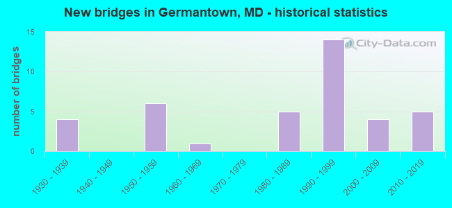
- New bridges - historical statistics
- 41930-1939
- 61950-1959
- 11960-1969
- 51980-1989
- 141990-1999
- 42000-2009
- 52010-2019

- Reconstructed bridges - Historical Statistics
- 31960-1969
- 11970-1979
- 21980-1989
- 01990-1999
- 12000-2009


- Bridge Condition - Deck
- 70.0%Good
- 10.0%Satisfactory
- 20.0%Fair

- Bridge Condition - Superstructure
- 9.1%Very good
- 50.0%Good
- 18.2%Satisfactory
- 18.2%Fair
- 4.5%Poor

- Bridge Condition - Substructure
- 4.5%Very good
- 50.0%Good
- 36.4%Satisfactory
- 9.1%Fair

- Bridge Condition - Channel
- 3.8%Excellent
- 23.1%Very good
- 34.6%Good
- 23.1%Satisfactory
- 11.5%Fair
- 3.8%Poor

- Bridge Condition - Culverts
- 14.3%Very good
- 35.7%Good
- 42.9%Satisfactory
- 7.1%Fair
Find on map >> Show street view
Structure Number: 10000015001801, Location: 3.12 MILES NORTH OF MD 28 (Lat: 39.188100, Lng: -77.341869), Route carried "on" structure: State highway 117, Year Built: 1932, Status: Open, Structure Length: 1.01m (3.31ft), Average Daily Traffic: 5,572 (year 2009), Truck Traffic: 8%, Average Future Daily Traffic: 5,825 (year 2026), Design Load: H 20, Features Intersected: BUCKLODGE BRANCH
Minimum Vertical Clearance: 30+ m (98+ ft), Kilometerpoint: 5.020, Lanes on structure: 2, Owner: State Highway Agency, Approaching Roadway Width: 6.4m (21.0ft), Skew: 3 degrees, Material/Design: Concrete, Design/Construction: Slab, Number Of Spans In Main Unit: 2, Length of Maximum Span: 4.3m (14.1ft), Curb-To-Curb Width: 8.2m (26.9ft), Out-to-Out Width: 9.4m (30.8ft)
Condition: Deck: Fair, Superstructure: Fair, Substructure: Fair, Channel: Poor, Inventory Rating: 67.1 metric tons, Method Used To Determine Inventory Rating: Load Factor (LF), Structural Evaluation: Somewhat better than minimum adequacy, Deck Geometry: High priority of replacement, Waterway Adequacy: Meets minimum limits, Approach Roadway Alignment: Equal to present minimum criteria, Length Of Structure Improvement: 1.01m (3.31ft), Designated Inspection Frequency: Every 24 months, Inspection Date: July 2020, Bridge Improvement Cost: $61,000, Roadway Improvement Cost: $6,000, Total Project Cost: $67,000, Deck Structure Type: Concrete Cast-file-Place, Wearing Surface/Protective System: Wearing Surface: Bituminous
Find on map >> Show street view
Structure Number: 10000015002101, Location: 0.39 MILE NORTH OF MD 117 (Lat: 39.188944, Lng: -77.310219), Route carried "on" structure: State highway 121, Year Built: 1984, Status: Open, Structure Length: 16.37m (53.71ft), Average Daily Traffic: 3,571 (year 2009), Truck Traffic: 8%, Average Future Daily Traffic: 5,357 (year 2029), Design Load: HS 20, Features Intersected: LITTLE SENECA LAKE
Minimum Vertical Clearance: 30+ m (98+ ft), Kilometerpoint: 0.628, Lanes on structure: 2, Owner: State Highway Agency, Approaching Roadway Width: 15.2m (49.9ft), Material/Design: Steel continuous, Design/Construction: Girder and Floorbeam System, Number Of Spans In Main Unit: 3, Length of Maximum Span: 61.0m (200.1ft), Curb-To-Curb Width: 13.4m (44.0ft), Out-to-Out Width: 14.4m (47.2ft)
Condition: Deck: Good, Superstructure: Good, Substructure: Satisfactory, Channel: Very good, Operating Rating: 63.9 metric tons, Method Used To Determine Operating Rating: Load Factor (LF), Inventory Rating: 38.1 metric tons, Method Used To Determine Inventory Rating: Load Factor (LF), Structural Evaluation: Equal to present minimum criteria, Deck Geometry: Better than present minimum criteria, Waterway Adequacy: Equal to present desirable criteria, Approach Roadway Alignment: Equal to present desirable criteria, Designated Inspection Frequency: Every 24 months, Critical Feature Inspection Frequency: Every 24 months, Underwater Inspection Frequency: Every 48 months, Inspection Date: June 2020, Critical Feature Inspection Date: June 2020, Underwater Inspection Date: August 2018, Deck Structure Type: Concrete Cast-file-Place, Wearing Surface/Protective System: Wearing Surface: Bituminous
Find on map >> Show street view
Structure Number: 10000015003801, Location: 0.64 MILE SOUTH OF MD 355 (Lat: 39.231567, Lng: -77.285264), Route carried "on" structure: State highway 121, Year Built: 1997, Status: Open, Structure Length: 8.99m (29.49ft), Average Daily Traffic: 13,714 (year 2009), Average Future Daily Traffic: 16,293 (year 2026), Design Load: HS 25 or greater, Features Intersected: IS 270
Minimum Vertical Clearance: 30+ m (98+ ft), Kilometerpoint: 6.162, Lanes on structure: 6, Lanes under structure: 8, Owner: State Highway Agency, Approaching Roadway Width: 22.6m (74.1ft), Skew: 22 degrees, Material/Design: Steel continuous, Design/Construction: Girder and Floorbeam System, Number Of Spans In Main Unit: 2, Length of Maximum Span: 44.2m (145.0ft), Curb or Sidewalk Widths: Left: 3.2m (10.5ft), Right: 1.7m (5.6ft), Curb-To-Curb Width: 24.4m (80.1ft), Out-to-Out Width: 30.1m (98.8ft)
Condition: Deck: Good, Superstructure: Good, Substructure: Good, Operating Rating: 83.4 metric tons, Method Used To Determine Operating Rating: Load Factor (LF), Inventory Rating: 49.9 metric tons, Method Used To Determine Inventory Rating: Load Factor (LF), Structural Evaluation: Better than present minimum criteria, Deck Geometry: Somewhat better than minimum adequacy, Underclear: Superior to present desirable criteria, Approach Roadway Alignment: Equal to present desirable criteria, Designated Inspection Frequency: Every 24 months, Inspection Date: August 2021, Deck Structure Type: Concrete Cast-file-Place, Wearing Surface/Protective System: Wearing Surface: Integral Concrete
Find on map >> Show street view
Structure Number: 10000015004101, Location: 0.33 M N OF AIRCRAFR DR (Lat: 39.184008, Lng: -77.255033), Route carried "on" structure: State highway 118, Year Built: 1954, Year Reconstructed: 1982, Status: Open, Structure Length: 9.75m (31.99ft), Average Daily Traffic: 28,651 (year 2009), Truck Traffic: 8%, Average Future Daily Traffic: 32,274 (year 2026), Design Load: HS 25 or greater, Features Intersected: IS 270
Minimum Vertical Clearance: 30+ m (98+ ft), Kilometerpoint: 9.976, Lanes on structure: 6, Lanes under structure: 8, Base Highway Network: Yes, Owner: State Highway Agency, Approaching Roadway Width: 25.6m (84.0ft), Skew: 21 degrees, Material/Design: Steel continuous, Design/Construction: Stringer/Multi-beam, Number Of Spans In Main Unit: 2, Length of Maximum Span: 48.5m (159.1ft), Curb or Sidewalk Widths: Left: 1.6m (5.2ft), Right: 1.6m (5.2ft), Curb-To-Curb Width: 25.6m (84.0ft), Out-to-Out Width: 33.2m (108.9ft)
Condition: Deck: Good, Superstructure: Good, Substructure: Good, Operating Rating: 68.5 metric tons, Method Used To Determine Operating Rating: Load Factor (LF), Inventory Rating: 40.8 metric tons, Method Used To Determine Inventory Rating: Load Factor (LF), Structural Evaluation: Better than present minimum criteria, Deck Geometry: Somewhat better than minimum adequacy, Underclear: Somewhat better than minimum adequacy, Approach Roadway Alignment: Equal to present desirable criteria, Designated Inspection Frequency: Every 24 months, Inspection Date: November 2021, Deck Structure Type: Concrete Cast-file-Place, Wearing Surface/Protective System: Wearing Surface: Integral Concrete, Deck Protection: Epoxy Coated Reinforcing
Find on map >> Show street view
Structure Number: 10000015004201, Location: 0.77 MILE SOUTH OF MD 118 (Lat: 39.175181, Lng: -77.246747), Route carried "on" structure: Interstate 270, Year Built: 1991, Status: Open, Structure Length: 4.42m (14.50ft), Average Daily Traffic: 133,720 (year 2009), Truck Traffic: 8%, Average Future Daily Traffic: 140,487 (year 2026), Design Load: HS 20+Mod, Features Intersected: MIDDLEBROOK ROAD
Minimum Vertical Clearance: 30+ m (98+ ft), Kilometerpoint: 22.478, Lanes on structure: 7, Lanes under structure: 6, Base Highway Network: Yes, Owner: State Highway Agency, Approaching Roadway Width: 39.6m (129.9ft), Skew: 21 degrees, Material/Design: Steel, Design/Construction: Stringer/Multi-beam, Number Of Spans In Main Unit: 1, Length of Maximum Span: 42.7m (140.1ft), Curb-To-Curb Width: 39.6m (129.9ft), Out-to-Out Width: 40.8m (133.9ft)
Condition: Deck: Good, Superstructure: Satisfactory, Substructure: Satisfactory, Operating Rating: 72.6 metric tons, Method Used To Determine Operating Rating: Load Factor (LF), Inventory Rating: 43.5 metric tons, Method Used To Determine Inventory Rating: Load Factor (LF), Structural Evaluation: Equal to present minimum criteria, Deck Geometry: Superior to present desirable criteria, Underclear: Meets minimum limits, Approach Roadway Alignment: Equal to present desirable criteria, Designated Inspection Frequency: Every 24 months, Inspection Date: June 2021, Deck Structure Type: Concrete Cast-file-Place, Wearing Surface/Protective System: Wearing Surface: Monolithic Concrete
Find on map >> Show street view
Structure Number: 10000015005501, Location: 1.32 MILES N OF MD 124 (Lat: 39.165844, Lng: -77.228033), Route carried "on" structure: State highway 355, Year Built: 2000, Status: Open, Structure Length: 8.78m (28.81ft), Average Daily Traffic: 31,050 (year 2009), Truck Traffic: 4%, Average Future Daily Traffic: 37,138 (year 2026), Design Load: HS 25 or greater, Features Intersected: GREAT SENECA CREEK
Minimum Vertical Clearance: 30+ m (98+ ft), Kilometerpoint: 26.951, Lanes on structure: 6, Base Highway Network: Yes, Owner: State Highway Agency, Approaching Roadway Width: 28.7m (94.2ft), Skew: 21 degrees, Material/Design: Steel continuous, Design/Construction: Girder and Floorbeam System, Number Of Spans In Main Unit: 3, Length of Maximum Span: 33.5m (109.9ft), Curb or Sidewalk Widths: Left: 1.6m (5.2ft), Right: 3.1m (10.2ft), Curb-To-Curb Width: 22.6m (74.1ft), Out-to-Out Width: 34.1m (111.9ft)
Condition: Deck: Good, Superstructure: Good, Substructure: Good, Channel: Excellent, Operating Rating: 81.6 metric tons, Method Used To Determine Operating Rating: Allowable Stress (AS), Inventory Rating: 49.0 metric tons, Method Used To Determine Inventory Rating: Allowable Stress (AS), Structural Evaluation: Better than present minimum criteria, Deck Geometry: Meets minimum limits, Waterway Adequacy: Superior to present desirable criteria, Approach Roadway Alignment: Equal to present desirable criteria, Designated Inspection Frequency: Every 24 months, Inspection Date: April 2020, Deck Structure Type: Concrete Cast-file-Place, Wearing Surface/Protective System: Wearing Surface: Monolithic Concrete, Deck Protection: Epoxy Coated Reinforcing
Find on map >> Show street view
Structure Number: 10000015009301, Location: 1.82 MILES EAST OF MD 118 (Lat: 39.154053, Lng: -77.251264), Route carried "on" structure: State highway 117, Year Built: 1951, Status: Open, Structure Length: 3.29m (10.79ft), Average Daily Traffic: 18,752 (year 2009), Truck Traffic: 8%, Average Future Daily Traffic: 21,633 (year 2026), Design Load: H 20, Features Intersected: GREAT SENECA CREEK
Minimum Vertical Clearance: 30+ m (98+ ft), Kilometerpoint: 15.109, Lanes on structure: 2, Owner: State Highway Agency, Approaching Roadway Width: 9.8m (32.2ft), Material/Design: Steel continuous, Design/Construction: Stringer/Multi-beam, Number Of Spans In Main Unit: 3, Length of Maximum Span: 12.2m (40.0ft), Curb-To-Curb Width: 7.9m (25.9ft), Out-to-Out Width: 9.9m (32.5ft)
Condition: Deck: Fair, Superstructure: Satisfactory, Substructure: Satisfactory, Channel: Good, Operating Rating: 71.7 metric tons, Method Used To Determine Operating Rating: Load Factor (LF), Inventory Rating: 43.1 metric tons, Method Used To Determine Inventory Rating: Load Factor (LF), Structural Evaluation: Equal to present minimum criteria, Deck Geometry: High priority of replacement, Waterway Adequacy: Equal to present minimum criteria, Approach Roadway Alignment: Equal to present desirable criteria, Length Of Structure Improvement: 3.29m (10.79ft), Designated Inspection Frequency: Every 24 months, Inspection Date: April 2021, Bridge Improvement Cost: $211,000, Roadway Improvement Cost: $21,000, Total Project Cost: $232,000, Deck Structure Type: Concrete Cast-file-Place, Wearing Surface/Protective System: Wearing Surface: Monolithic Concrete
Find on map >> Show street view
Structure Number: 10000015009402, Location: 1.21 MILES EAST OF MD 118 (Lat: 39.155628, Lng: -77.262089), Route carried "on" structure: State highway 117, Year Built: 1951, Status: Open, Structure Length: 0.76m (2.49ft), Average Daily Traffic: 18,752 (year 2009), Truck Traffic: 8%, Average Future Daily Traffic: 21,633 (year 2026), Design Load: H 20, Features Intersected: GUNNERS BRANCH
Minimum Vertical Clearance: 30+ m (98+ ft), Kilometerpoint: 14.127, Lanes on structure: 2, Owner: State Highway Agency, Approaching Roadway Width: 9.8m (32.2ft), Material/Design: Concrete, Design/Construction: Culvert, Length of Maximum Span: 3.7m (12.1ft)
Condition: Channel: Fair, Culverts: Fair, Operating Rating: 89.8 metric tons, Method Used To Determine Operating Rating: Load Factor (LF), Inventory Rating: 78.9 metric tons, Method Used To Determine Inventory Rating: Load Factor (LF), Structural Evaluation: Somewhat better than minimum adequacy, Waterway Adequacy: Equal to present desirable criteria, Approach Roadway Alignment: Equal to present desirable criteria, Designated Inspection Frequency: Every 24 months, Inspection Date: July 2020
Find on map >> Show street view
Structure Number: 10000015009503, Location: 1.03 MILES EAST OF MD 121 (Lat: 39.175108, Lng: -77.299983), Route carried "on" structure: State highway 117, Year Built: 1953, Year Reconstructed: 1972, Status: Open, Structure Length: 1.74m (5.71ft), Average Daily Traffic: 7,042 (year 2009), Truck Traffic: 8%, Average Future Daily Traffic: 7,590 (year 2026), Design Load: H 20, Features Intersected: LITTLE SENECA CREEK
Minimum Vertical Clearance: 30+ m (98+ ft), Kilometerpoint: 10.095, Lanes on structure: 2, Owner: State Highway Agency, Approaching Roadway Width: 10.4m (34.1ft), Skew: 3 degrees, Material/Design: Steel, Design/Construction: Culvert, Number Of Spans In Main Unit: 2, Length of Maximum Span: 8.2m (26.9ft), Curb-To-Curb Width: 7.9m (25.9ft), Out-to-Out Width: 9.1m (29.9ft)
Condition: Channel: Good, Culverts: Satisfactory, Structural Evaluation: Equal to present minimum criteria, Deck Geometry: High priority of replacement, Waterway Adequacy: Equal to present desirable criteria, Approach Roadway Alignment: Equal to present desirable criteria, Length Of Structure Improvement: 1.74m (5.71ft), Designated Inspection Frequency: Every 24 months, Underwater Inspection Frequency: Every 48 months, Inspection Date: July 2020, Underwater Inspection Date: July 2020, Bridge Improvement Cost: $103,000, Roadway Improvement Cost: $10,000, Total Project Cost: $113,000, Deck Structure Type: Concrete Cast-file-Place, Wearing Surface/Protective System: Wearing Surface: Bituminous
Find on map >> Show street view
Structure Number: 10000015016903, Location: IS 270/MIDDLEBROOK INTER (Lat: 39.177217, Lng: -77.247381), Route carried "on" structure: Ramp Interstate 270, Year Built: 1991, Status: Open, Structure Length: 1.09m (3.58ft), Average Daily Traffic: 6,945 (year 2006), Truck Traffic: 8%, Average Future Daily Traffic: 7,501 (year 2026), Design Load: HS 20, Features Intersected: GUNNERS BRANCH
Minimum Vertical Clearance: 30+ m (98+ ft), Kilometerpoint: 0.098, Lanes on structure: 2, Base Highway Network: Yes, Owner: State Highway Agency, Approaching Roadway Width: 8.2m (26.9ft), Skew: 5 degrees, Material/Design: Steel, Design/Construction: Culvert, Length of Maximum Span: 4.9m (16.1ft)
Condition: Channel: Good, Culverts: Good, Structural Evaluation: Better than present minimum criteria, Waterway Adequacy: Superior to present desirable criteria, Approach Roadway Alignment: Equal to present desirable criteria, Designated Inspection Frequency: Every 24 months, Inspection Date: June 2020
Find on map >> Show street view
Structure Number: 100000150172011, Location: .5 MI S OF MIDDLEBROOK RD (Lat: 39.168153, Lng: -77.266475), Route carried "on" structure: State highway 119, Year Built: 1987, Status: Open, Structure Length: 10.12m (33.20ft), Average Daily Traffic: 7,535 (year 2012), Truck Traffic: 5%, Average Future Daily Traffic: 9,042 (year 2032), Design Load: HS 20, Features Intersected: GUNNERS BR,CSXT RR
Minimum Vertical Clearance: 30+ m (98+ ft), Kilometerpoint: 11.089, Lanes on structure: 2, Base Highway Network: Yes, Owner: State Highway Agency, Approaching Roadway Width: 8.2m (26.9ft), Material/Design: Steel continuous, Design/Construction: Stringer/Multi-beam, Number Of Spans In Main Unit: 3, Length of Maximum Span: 41.5m (136.2ft), Curb or Sidewalk Widths: Left: 2.9m (9.5ft), Right: 0.0m, Curb-To-Curb Width: 11.6m (38.1ft), Out-to-Out Width: 15.3m (50.2ft)
Condition: Deck: Good, Superstructure: Good, Substructure: Good, Channel: Very good, Operating Rating: 66.7 metric tons, Method Used To Determine Operating Rating: Load Factor (LF), Inventory Rating: 39.9 metric tons, Method Used To Determine Inventory Rating: Load Factor (LF), Structural Evaluation: Better than present minimum criteria, Deck Geometry: Better than present minimum criteria, Underclear: Superior to present desirable criteria, Waterway Adequacy: Equal to present desirable criteria, Approach Roadway Alignment: Equal to present desirable criteria, Length Of Structure Improvement: 10.12m (33.20ft), Designated Inspection Frequency: Every 24 months, Inspection Date: September 2020, Bridge Improvement Cost: $17,000, Total Project Cost: $17,000, Deck Structure Type: Concrete Cast-file-Place, Wearing Surface/Protective System: Wearing Surface: Integral Concrete, Deck Protection: Epoxy Coated Reinforcing
Find on map >> Show street view
Structure Number: 100000150172012, Location: .5 MI S OF MIDDLEBROOK RD (Lat: 39.168681, Lng: -77.265533), Route carried "on" structure: State highway 119, Year Built: 1987, Status: Open, Structure Length: 10.03m (32.91ft), Average Daily Traffic: 6,955 (year 2012), Truck Traffic: 5%, Average Future Daily Traffic: 8,346 (year 2032), Design Load: HS 20, Features Intersected: GUNNERS BR,CSXT RR
Minimum Vertical Clearance: 30+ m (98+ ft), Kilometerpoint: 11.089, Lanes on structure: 2, Base Highway Network: Yes, Owner: State Highway Agency, Approaching Roadway Width: 8.5m (27.9ft), Material/Design: Steel continuous, Design/Construction: Stringer/Multi-beam, Number Of Spans In Main Unit: 3, Length of Maximum Span: 41.1m (134.8ft), Curb or Sidewalk Widths: Left: 0.0m, Right: 1.2m (3.9ft), Curb-To-Curb Width: 11.6m (38.1ft), Out-to-Out Width: 13.6m (44.6ft)
Condition: Deck: Good, Superstructure: Good, Substructure: Good, Channel: Very good, Operating Rating: 72.1 metric tons, Method Used To Determine Operating Rating: Load Factor (LF), Inventory Rating: 45.8 metric tons, Method Used To Determine Inventory Rating: Load Factor (LF), Structural Evaluation: Better than present minimum criteria, Deck Geometry: Better than present minimum criteria, Waterway Adequacy: Equal to present desirable criteria, Approach Roadway Alignment: Equal to present desirable criteria, Length Of Structure Improvement: 10.03m (32.91ft), Designated Inspection Frequency: Every 24 months, Inspection Date: September 2020, Bridge Improvement Cost: $15,000, Total Project Cost: $15,000, Deck Structure Type: Concrete Cast-file-Place, Wearing Surface/Protective System: Wearing Surface: Integral Concrete, Deck Protection: Epoxy Coated Reinforcing
Find on map >> Show street view
Structure Number: 10000015017901, Location: 0.98 MILE N OF MD 117 (Lat: 39.174306, Lng: -77.273325), Route carried "on" structure: State highway 118, Year Built: 1998, Status: Open, Structure Length: 4.33m (14.21ft), Average Daily Traffic: 25,451 (year 2009), Truck Traffic: 5%, Average Future Daily Traffic: 27,143 (year 2026), Design Load: HS 20, Features Intersected: CSX TRANSPORTATION
Minimum Vertical Clearance: 30+ m (98+ ft), Kilometerpoint: 8.013, Lanes on structure: 6, Base Highway Network: Yes, Owner: State Highway Agency, Approaching Roadway Width: 33.2m (108.9ft), Skew: 22 degrees, Material/Design: Steel, Design/Construction: Stringer/Multi-beam, Number Of Spans In Main Unit: 1, Length of Maximum Span: 41.5m (136.2ft), Curb or Sidewalk Widths: Left: 24.4m (80.1ft), Right: 24.4m (80.1ft), Curb-To-Curb Width: 23.2m (76.1ft), Out-to-Out Width: 34.7m (113.8ft)
Condition: Deck: Good, Superstructure: Very good, Substructure: Good, Inventory Rating: 74.8 metric tons, Method Used To Determine Inventory Rating: Load Factor (LF), Structural Evaluation: Better than present minimum criteria, Deck Geometry: Meets minimum limits, Underclear: Somewhat better than minimum adequacy, Approach Roadway Alignment: Equal to present desirable criteria, Designated Inspection Frequency: Every 24 months, Inspection Date: March 2021, Deck Structure Type: Concrete Cast-file-Place, Wearing Surface/Protective System: Wearing Surface: Integral Concrete, Deck Protection: Epoxy Coated Reinforcing
Find on map >> Show street view
Structure Number: 10000015018403, Location: 0.1 MILE WEST OF IS 270 (Lat: 39.182786, Lng: -77.255556), Route carried "on" structure: County highway 141, Year Built: 1959, Year Reconstructed: 1991, Status: Open, Structure Length: 0.88m (2.89ft), Average Daily Traffic: 16,296 (year 2006), Average Future Daily Traffic: 19,516 (year 2026), Design Load: HS 20, Features Intersected: GUNNERS BRANCH
Minimum Vertical Clearance: 30+ m (98+ ft), Kilometerpoint: 0.000, Lanes on structure: 7, Owner: State Highway Agency, Approaching Roadway Width: 34.7m (113.8ft), Skew: 3 degrees, Material/Design: Steel, Design/Construction: Culvert, Number Of Spans In Main Unit: 2, Length of Maximum Span: 4.0m (13.1ft)
Condition: Channel: Satisfactory, Culverts: Good, Structural Evaluation: Better than present minimum criteria, Waterway Adequacy: Equal to present minimum criteria, Approach Roadway Alignment: Equal to present desirable criteria, Designated Inspection Frequency: Every 24 months, Inspection Date: March 2021, Wearing Surface/Protective System: Wearing Surface: Bituminous
Find on map >> Show street view
Structure Number: 200000M-000101, Location: 1.0 MILES WEST OF MD 355 (Lat: 39.214650, Lng: -77.270772), Route carried "on" structure: County highway 231, Year Built: 1934, Year Reconstructed: 1972, Status: Open, Structure Length: 1.92m (6.30ft), Average Daily Traffic: 1,035 (year 2019), Truck Traffic: 3%, Average Future Daily Traffic: 1,568 (year 2041), Features Intersected: LITTLE SENECA CREEK, Facility Carried by Structure: WEST OLD BALTIMORE
Minimum Vertical Clearance: 30+ m (98+ ft), Kilometerpoint: 1.593, Lanes on structure: 2, Owner: County Highway Agency, Approaching Roadway Width: 6.4m (21.0ft), Material/Design: Steel, Design/Construction: Stringer/Multi-beam, Number Of Spans In Main Unit: 1, Length of Maximum Span: 17.4m (57.1ft), Curb-To-Curb Width: 7.2m (23.6ft), Out-to-Out Width: 7.3m (24.0ft)
Condition: Deck: Satisfactory, Superstructure: Fair, Substructure: Satisfactory, Channel: Fair, Inventory Rating: 62.6 metric tons, Method Used To Determine Inventory Rating: Load Factor (LF), Structural Evaluation: Somewhat better than minimum adequacy, Deck Geometry: High priority of corrective action, Waterway Adequacy: Equal to present minimum criteria, Approach Roadway Alignment: Equal to present desirable criteria, Length Of Structure Improvement: 1.92m (6.30ft), Designated Inspection Frequency: Every 24 months, Inspection Date: June 2020, Bridge Improvement Cost: $72,000, Roadway Improvement Cost: $7,000, Total Project Cost: $79,000, Deck Structure Type: Corrugated Steel, Wearing Surface/Protective System: Wearing Surface: Bituminous
Find on map >> Show street view
Structure Number: 200000M-004701, Location: 0.7 MI N OF JCT SR 28 (Lat: 39.127111, Lng: -77.314111), Route carried "on" structure: County highway 263, Year Built: 1965, Year Reconstructed: 1993, Status: Open, Structure Length: 2.26m (7.41ft), Average Daily Traffic: 373 (year 2019), Truck Traffic: 5%, Average Future Daily Traffic: 479 (year 2041), Design Load: HS 20, Features Intersected: GREAT SENECA CREEK, Facility Carried by Structure: BLACK ROCK RD
Minimum Vertical Clearance: 30+ m (98+ ft), Kilometerpoint: 2.977, Lanes on structure: 1, Owner: County Highway Agency, Approaching Roadway Width: 4.6m (15.1ft), Skew: 3 degrees, Material/Design: Steel, Design/Construction: Stringer/Multi-beam, Number Of Spans In Main Unit: 2, Length of Maximum Span: 11.9m (39.0ft), Curb-To-Curb Width: 4.5m (14.8ft), Out-to-Out Width: 4.6m (15.1ft)
Condition: Deck: Satisfactory, Superstructure: Fair, Substructure: Fair, Channel: Satisfactory, Operating Rating: 85.3 metric tons, Method Used To Determine Operating Rating: Load Factor (LF), Inventory Rating: 51.2 metric tons, Method Used To Determine Inventory Rating: Load Factor (LF), Structural Evaluation: Somewhat better than minimum adequacy, Deck Geometry: High priority of replacement, Waterway Adequacy: Better than present minimum criteria, Approach Roadway Alignment: High priority of corrective action, Length Of Structure Improvement: 2.26m (7.41ft), Designated Inspection Frequency: Every 24 months, Inspection Date: May 2020, Bridge Improvement Cost: $17,000, Total Project Cost: $17,000, Deck Structure Type: Corrugated Steel, Wearing Surface/Protective System: Wearing Surface: Bituminous
Find on map >> Show street view
Structure Number: 200000M-006401, Location: 2.1 MILES EAST OF MD 27 (Lat: 39.201308, Lng: -77.203872), Route carried "on" structure: County highway 27, Year Built: 1936, Year Reconstructed: 1972, Status: Open, Structure Length: 1.95m (6.40ft), Average Daily Traffic: 15,739 (year 2021), Truck Traffic: 3%, Average Future Daily Traffic: 20,540 (year 2041), Design Load: H 20, Features Intersected: GREAT SENECA CREEK, Facility Carried by Structure: BRINK ROAD
Minimum Vertical Clearance: 30+ m (98+ ft), Kilometerpoint: 4.328, Lanes on structure: 2, Owner: County Highway Agency, Approaching Roadway Width: 7.9m (25.9ft), Material/Design: Steel, Design/Construction: Stringer/Multi-beam, Number Of Spans In Main Unit: 1, Length of Maximum Span: 17.7m (58.1ft), Curb-To-Curb Width: 7.2m (23.6ft), Out-to-Out Width: 7.7m (25.3ft)
Condition: Deck: Fair, Superstructure: Poor, Substructure: Satisfactory, Channel: Fair, Operating Rating: 71.7 metric tons, Method Used To Determine Operating Rating: Load Factor (LF), Inventory Rating: 42.6 metric tons, Method Used To Determine Inventory Rating: Load Factor (LF), Structural Evaluation: Meets minimum limits, Deck Geometry: High priority of replacement, Waterway Adequacy: Somewhat better than minimum adequacy, Approach Roadway Alignment: Equal to present minimum criteria, Length Of Structure Improvement: 1.95m (6.40ft), Designated Inspection Frequency: Every 12 months, Inspection Date: Febuary 2021, Bridge Improvement Cost: $194,000, Roadway Improvement Cost: $19,000, Total Project Cost: $291,000, Deck Structure Type: Corrugated Steel, Wearing Surface/Protective System: Wearing Surface: Bituminous
Find on map >> Show street view
Structure Number: 200000M-006801, Location: 2.4 MI SW OF MD 124 (Lat: 39.217797, Lng: -77.214042), Route carried "on" structure: County highway 30, Year Built: 1935, Year Reconstructed: 2006, Status: Open, Structure Length: 0.98m (3.22ft), Average Daily Traffic: 412 (year 2019), Truck Traffic: 2%, Average Future Daily Traffic: 556 (year 2039), Features Intersected: WILDCAT BRANCH, Facility Carried by Structure: WILDCAT ROAD
Minimum Vertical Clearance: 30+ m (98+ ft), Kilometerpoint: 4.312, Lanes on structure: 1, Owner: County Highway Agency, Approaching Roadway Width: 5.2m (17.1ft), Material/Design: Steel, Design/Construction: Stringer/Multi-beam, Number Of Spans In Main Unit: 1, Length of Maximum Span: 7.6m (24.9ft), Curb-To-Curb Width: 4.2m (13.8ft), Out-to-Out Width: 4.6m (15.1ft)
Condition: Deck: Fair, Superstructure: Fair, Substructure: Satisfactory, Channel: Satisfactory, Inventory Rating: 63.9 metric tons, Method Used To Determine Inventory Rating: Load Factor (LF), Structural Evaluation: Somewhat better than minimum adequacy, Deck Geometry: High priority of replacement, Waterway Adequacy: Equal to present minimum criteria, Approach Roadway Alignment: Equal to present minimum criteria, Length Of Structure Improvement: 0.88m (2.89ft), Designated Inspection Frequency: Every 24 months, Inspection Date: June 2020, Bridge Improvement Cost: $19,000, Roadway Improvement Cost: $2,000, Total Project Cost: $21,000, Deck Structure Type: Corrugated Steel, Wearing Surface/Protective System: Wearing Surface: Bituminous
Find on map >> Show street view
Structure Number: 200000M-013401, Location: 0.5 MI NORTH OF MD 117 (Lat: 39.160047, Lng: -77.251164), Route carried "on" structure: County highway 226, Year Built: 1986, Status: Open, Structure Length: 3.57m (11.71ft), Average Daily Traffic: 6,593 (year 2019), Truck Traffic: 5%, Average Future Daily Traffic: 8,968 (year 2039), Design Load: HS 20, Features Intersected: CSXT RAILROAD, Facility Carried by Structure: WARING STATION ROA
Minimum Vertical Clearance: 30+ m (98+ ft), Kilometerpoint: 1.834, Lanes on structure: 2, Owner: County Highway Agency, Approaching Roadway Width: 14.6m (47.9ft), Skew: 1 degrees, Material/Design: Steel, Design/Construction: Stringer/Multi-beam, Number Of Spans In Main Unit: 1, Length of Maximum Span: 35.1m (115.2ft), Curb or Sidewalk Widths: Left: 1.5m (4.9ft), Right: 1.5m (4.9ft), Curb-To-Curb Width: 15.2m (49.9ft), Out-to-Out Width: 18.9m (62.0ft)
Condition: Deck: Good, Superstructure: Good, Substructure: Satisfactory, Inventory Rating: 65.3 metric tons, Method Used To Determine Inventory Rating: Load Factor (LF), Structural Evaluation: Equal to present minimum criteria, Deck Geometry: Superior to present desirable criteria, Underclear: Equal to present minimum criteria, Approach Roadway Alignment: Equal to present desirable criteria, Designated Inspection Frequency: Every 24 months, Inspection Date: October 2020, Deck Structure Type: Concrete Cast-file-Place, Wearing Surface/Protective System: Wearing Surface: Monolithic Concrete, Deck Protection: Epoxy Coated Reinforcing
Find on map >> Show street view
Structure Number: 200000M-022102, Location: 0.5 MI NE OF JCT SR 355 (Lat: 39.239450, Lng: -77.271875), Route carried "on" structure: County highway 15, Year Built: 2017, Status: Open, Structure Length: 1.08m (3.54ft), Average Daily Traffic: 2,882 (year 2021), Truck Traffic: 3%, Average Future Daily Traffic: 4,383 (year 2041), Features Intersected: TRIBUTARY TO LITTLE SENE, Facility Carried by Structure: STRINGTOWN ROAD
Minimum Vertical Clearance: 30+ m (98+ ft), Kilometerpoint: 0.000, Lanes on structure: 2, Owner: County Highway Agency, Approaching Roadway Width: 22.3m (73.2ft), Skew: 20 degrees, Material/Design: Concrete, Design/Construction: Culvert, Length of Maximum Span: 5.5m (18.0ft)
Condition: Channel: Very good, Culverts: Satisfactory, Operating Rating: 32.7 metric tons, Method Used To Determine Operating Rating: Field evaluation and documented engineering judgment, Inventory Rating: 32.7 metric tons, Method Used To Determine Inventory Rating: Field evaluation and documented engineering judgment, Structural Evaluation: Equal to present minimum criteria, Waterway Adequacy: Superior to present desirable criteria, Approach Roadway Alignment: Equal to present desirable criteria, Designated Inspection Frequency: Every 24 months, Inspection Date: December 2021
Find on map >> Show street view
Structure Number: 200000M-023102, Location: 0.1 MI N OF CRYSTAL ROCK (Lat: 39.197278, Lng: -77.272889), Route carried "on" structure: County highway 6589, Year Built: 2018, Status: Open, Structure Length: 1.01m (3.31ft), Average Daily Traffic: 144 (year 2018), Truck Traffic: 5%, Average Future Daily Traffic: 198 (year 2039), Features Intersected: LITTLE SENECA CREEK TRIB, Facility Carried by Structure: KINSTER DRIVE
Minimum Vertical Clearance: 30+ m (98+ ft), Kilometerpoint: 0.000, Lanes on structure: 2, Owner: County Highway Agency, Approaching Roadway Width: 16.5m (54.1ft), Skew: 21 degrees, Material/Design: Concrete, Design/Construction: Culvert, Length of Maximum Span: 3.4m (11.2ft), Curb or Sidewalk Widths: Left: 2.4m (7.9ft), Right: 1.2m (3.9ft)
Condition: Channel: Good, Culverts: Very good, Operating Rating: 49.6 metric tons, Method Used To Determine Operating Rating: Load and Resistance Factor Rating (LRFR) rating reported by rating factor(RF) method using HL-93 loadings, Inventory Rating: 38.2 metric tons, Method Used To Determine Inventory Rating: Load and Resistance Factor Rating (LRFR) rating reported by rating factor(RF) method using HL-93 loadings, Structural Evaluation: Equal to present desirable criteria, Waterway Adequacy: Better than present minimum criteria, Approach Roadway Alignment: Equal to present desirable criteria, Designated Inspection Frequency: Every 24 months, Inspection Date: March 2020
Find on map >> Show street view
Structure Number: 200000M-023203, Location: 0.5 MI N OF MD RTE 117 (Lat: 39.175375, Lng: -77.294458), Route carried "on" structure: County highway 6948, Year Built: 1994, Status: Open, Structure Length: 0.79m (2.59ft), Average Daily Traffic: 150 (year 2019), Truck Traffic: 3%, Average Future Daily Traffic: 200 (year 2041), Design Load: HS 20, Features Intersected: TRIBUTARY TO LITTLE SENE, Facility Carried by Structure: RANWORTH DRIVE
Minimum Vertical Clearance: 30+ m (98+ ft), Kilometerpoint: 0.000, Lanes on structure: 2, Owner: County Highway Agency, Approaching Roadway Width: 11.0m (36.1ft), Material/Design: Steel, Design/Construction: Culvert, Length of Maximum Span: 3.4m (11.2ft), Curb or Sidewalk Widths: Left: 1.2m (3.9ft), Right: 1.2m (3.9ft)
Condition: Channel: Satisfactory, Culverts: Good, Structural Evaluation: Better than present minimum criteria, Waterway Adequacy: Equal to present minimum criteria, Approach Roadway Alignment: Equal to present desirable criteria, Designated Inspection Frequency: Every 24 months, Inspection Date: December 2020
Find on map >> Show street view
Structure Number: 200000M-0250013, Location: 0.2 MI SW OF JCT I-270 (Lat: 39.195022, Lng: -77.267775), Route carried "on" structure: County highway 4556, Year Built: 1995, Status: Open, Structure Length: 5.73m (18.80ft), Average Daily Traffic: 22,305 (year 2021), Truck Traffic: 5%, Average Future Daily Traffic: 30,088 (year 2041), Design Load: HS 25 or greater, Features Intersected: CENTURY BOULEVARD, Facility Carried by Structure: FATHER HURLEY BOUL
Minimum Vertical Clearance: 30+ m (98+ ft), Kilometerpoint: 0.467, Lanes on structure: 3, Lanes under structure: 4, Base Highway Network: Yes, Owner: County Highway Agency, Approaching Roadway Width: 11.6m (38.1ft), Material/Design: Steel continuous, Design/Construction: Stringer/Multi-beam, Number Of Spans In Main Unit: 2, Length of Maximum Span: 31.1m (102.0ft), Curb or Sidewalk Widths: Left: 0.0m, Right: 2.5m (8.2ft), Curb-To-Curb Width: 11.7m (38.4ft), Out-to-Out Width: 15.2m (49.9ft)
Condition: Deck: Good, Superstructure: Good, Substructure: Good, Operating Rating: 73.0 metric tons, Method Used To Determine Operating Rating: Load Factor (LF), Inventory Rating: 43.5 metric tons, Method Used To Determine Inventory Rating: Load Factor (LF), Structural Evaluation: Better than present minimum criteria, Deck Geometry: High priority of corrective action, Underclear: Equal to present minimum criteria, Approach Roadway Alignment: Equal to present desirable criteria, Length Of Structure Improvement: 5.73m (18.80ft), Designated Inspection Frequency: Every 24 months, Inspection Date: August 2021, Bridge Improvement Cost: $350,000, Roadway Improvement Cost: $35,000, Total Project Cost: $525,000, Deck Structure Type: Concrete Cast-file-Place, Wearing Surface/Protective System: Wearing Surface: Integral Concrete
Find on map >> Show street view
Structure Number: 200000M-0250014, Location: 0.2 MI SW OF JCT I-270 (Lat: 39.195600, Lng: -77.267519), Route carried "on" structure: County highway 4556, Year Built: 1995, Status: Open, Structure Length: 5.73m (18.80ft), Average Daily Traffic: 22,276 (year 2021), Truck Traffic: 5%, Average Future Daily Traffic: 30,088 (year 2041), Design Load: HS 25 or greater, Features Intersected: CENTURY BOULEVARD, Facility Carried by Structure: FATHER HURLEY BOUL
Minimum Vertical Clearance: 30+ m (98+ ft), Kilometerpoint: 0.467, Lanes on structure: 4, Lanes under structure: 4, Base Highway Network: Yes, Owner: County Highway Agency, Approaching Roadway Width: 11.6m (38.1ft), Material/Design: Steel continuous, Design/Construction: Stringer/Multi-beam, Number Of Spans In Main Unit: 2, Length of Maximum Span: 31.1m (102.0ft), Curb or Sidewalk Widths: Left: 3.1m (10.2ft), Right: 0.0m, Curb-To-Curb Width: 15.4m (50.5ft), Out-to-Out Width: 19.5m (64.0ft)
Condition: Deck: Good, Superstructure: Good, Substructure: Good, Operating Rating: 73.0 metric tons, Method Used To Determine Operating Rating: Load Factor (LF), Inventory Rating: 43.5 metric tons, Method Used To Determine Inventory Rating: Load Factor (LF), Structural Evaluation: Better than present minimum criteria, Deck Geometry: Meets minimum limits, Underclear: Superior to present desirable criteria, Approach Roadway Alignment: Equal to present desirable criteria, Length Of Structure Improvement: 5.73m (18.80ft), Designated Inspection Frequency: Every 24 months, Inspection Date: August 2021, Bridge Improvement Cost: $350,000, Roadway Improvement Cost: $35,000, Total Project Cost: $525,000, Deck Structure Type: Concrete Cast-file-Place, Wearing Surface/Protective System: Wearing Surface: Integral Concrete, Deck Protection: Epoxy Coated Reinforcing
Find on map >> Show street view
Structure Number: 200000M-0251013, Location: 0.5MI E. OF CRYSTAL RK DR (Lat: 39.197319, Lng: -77.263617), Route carried "on" structure: County highway 4556, Year Built: 1995, Status: Open, Structure Length: 9.81m (32.19ft), Average Daily Traffic: 20,160 (year 2021), Truck Traffic: 5%, Average Future Daily Traffic: 27,195 (year 2041), Design Load: HS 25 or greater, Features Intersected: I-270, Facility Carried by Structure: FATHER HURLEY BOUL
Minimum Vertical Clearance: 30+ m (98+ ft), Kilometerpoint: 0.000, Lanes on structure: 4, Lanes under structure: 8, Base Highway Network: Yes (Inventory Route: 15000CO0, Subroute: 56), Owner: County Highway Agency, Approaching Roadway Width: 15.2m (49.9ft), Material/Design: Steel continuous, Design/Construction: Stringer/Multi-beam, Number Of Spans In Main Unit: 2, Length of Maximum Span: 48.8m (160.1ft), Curb or Sidewalk Widths: Left: 0.0m, Right: 2.5m (8.2ft), Curb-To-Curb Width: 15.2m (49.9ft), Out-to-Out Width: 18.7m (61.4ft)
Condition: Deck: Good, Superstructure: Good, Substructure: Good, Inventory Rating: 62.1 metric tons, Method Used To Determine Inventory Rating: Load Factor (LF), Structural Evaluation: Better than present minimum criteria, Deck Geometry: High priority of corrective action, Underclear: Equal to present desirable criteria, Approach Roadway Alignment: Equal to present desirable criteria, Designated Inspection Frequency: Every 24 months, Inspection Date: August 2021, Deck Structure Type: Concrete Cast-file-Place, Wearing Surface/Protective System: Wearing Surface: Integral Concrete
Find on map >> Show street view
Structure Number: 200000M-0251014, Location: .5 MI E. OF CRYSTAL RK DR (Lat: 39.198083, Lng: -77.262919), Route carried "on" structure: County highway 4556, Year Built: 1995, Status: Open, Structure Length: 9.81m (32.19ft), Average Daily Traffic: 20,124 (year 2021), Truck Traffic: 5%, Average Future Daily Traffic: 27,195 (year 2041), Design Load: HS 25 or greater, Features Intersected: I-270, Facility Carried by Structure: FATHER HURLEY BOUL
Minimum Vertical Clearance: 30+ m (98+ ft), Kilometerpoint: 0.000, Lanes on structure: 4, Lanes under structure: 8, Base Highway Network: Yes (Inventory Route: 15000CO0, Subroute: 56), Owner: County Highway Agency, Approaching Roadway Width: 15.2m (49.9ft), Material/Design: Steel continuous, Design/Construction: Stringer/Multi-beam, Number Of Spans In Main Unit: 2, Length of Maximum Span: 48.8m (160.1ft), Curb or Sidewalk Widths: Left: 3.1m (10.2ft), Right: 0.0m, Curb-To-Curb Width: 15.2m (49.9ft), Out-to-Out Width: 19.3m (63.3ft)
Condition: Deck: Good, Superstructure: Good, Substructure: Good, Inventory Rating: 62.1 metric tons, Method Used To Determine Inventory Rating: Load Factor (LF), Structural Evaluation: Better than present minimum criteria, Deck Geometry: High priority of corrective action, Underclear: Better than present minimum criteria, Approach Roadway Alignment: Equal to present desirable criteria, Designated Inspection Frequency: Every 24 months, Inspection Date: August 2021, Deck Structure Type: Concrete Cast-file-Place, Wearing Surface/Protective System: Wearing Surface: Integral Concrete
Find on map >> Show street view
Structure Number: 200000M-025303, Location: 0.3 MI SE OF JCT I-270 (Lat: 39.195869, Lng: -77.266756), Route carried "on" structure: County highway 7030, Year Built: 1995, Status: Open, Structure Length: 1.37m (4.49ft), Average Daily Traffic: 44,485 (year 2019), Truck Traffic: 5%, Average Future Daily Traffic: 60,032 (year 2039), Design Load: HS 20, Features Intersected: TRIB TO LITTLE SENECA CR, Facility Carried by Structure: FATHER HURLEY BOUL
Minimum Vertical Clearance: 30+ m (98+ ft), Kilometerpoint: 0.000, Lanes on structure: 7, Owner: County Highway Agency, Approaching Roadway Width: 29.9m (98.1ft), Skew: 4 degrees, Material/Design: Steel, Design/Construction: Culvert, Length of Maximum Span: 4.6m (15.1ft), Curb or Sidewalk Widths: Left: 1.2m (3.9ft), Right: 1.5m (4.9ft)
Condition: Channel: Good, Culverts: Satisfactory, Structural Evaluation: Equal to present minimum criteria, Waterway Adequacy: Equal to present desirable criteria, Approach Roadway Alignment: Equal to present desirable criteria, Designated Inspection Frequency: Every 24 months, Inspection Date: August 2020
Find on map >> Show street view
Structure Number: 200000M-033501, Location: 0.7 MI WEST OF MD 27 (Lat: 39.236097, Lng: -77.248922), Route carried "on" structure: County highway 20, Year Built: 2006, Status: Open, Structure Length: 1.40m (4.59ft), Average Daily Traffic: 4,855 (year 2017), Truck Traffic: 5%, Average Future Daily Traffic: 6,000 (year 2037), Features Intersected: LITTLE SENECA CREEK, Facility Carried by Structure: SKYLARK ROAD
Minimum Vertical Clearance: 30+ m (98+ ft), Kilometerpoint: 1.239, Lanes on structure: 2, Owner: County Highway Agency, Approaching Roadway Width: 7.9m (25.9ft), Material/Design: Steel, Design/Construction: Arch - Deck, Number Of Spans In Main Unit: 1, Length of Maximum Span: 14.0m (45.9ft), Curb or Sidewalk Widths: Left: 0.2m (0.7ft), Right: 0.2m (0.7ft), Curb-To-Curb Width: 7.9m (25.9ft), Out-to-Out Width: 29.3m (96.1ft)
Condition: Superstructure: Satisfactory, Substructure: Good, Channel: Good, Inventory Rating: 84.4 metric tons, Method Used To Determine Inventory Rating: Load Factor (LF), Structural Evaluation: Equal to present minimum criteria, Deck Geometry: High priority of corrective action, Waterway Adequacy: Equal to present desirable criteria, Approach Roadway Alignment: Equal to present desirable criteria, Length Of Structure Improvement: 2.93m (9.61ft), Designated Inspection Frequency: Every 24 months, Inspection Date: Febuary 2021, Bridge Improvement Cost: $41,000, Total Project Cost: $41,000, Wearing Surface/Protective System: Wearing Surface: Bituminous
Find on map >> Show street view
Structure Number: 200000M-034101, Location: NORTH OF MD 118 (Lat: 39.177372, Lng: -77.281897), Route carried "on" structure: County highway 6221, Year Built: 2010, Status: Open, Structure Length: 2.84m (9.32ft), Average Daily Traffic: 562 (year 2019), Truck Traffic: 5%, Average Future Daily Traffic: 752 (year 2039), Design Load: HS 25 or greater, Features Intersected: CSXT RAILROAD, Facility Carried by Structure: FATHER HURLEY BOUL
Minimum Vertical Clearance: 30+ m (98+ ft), Kilometerpoint: 2.961, Lanes on structure: 5, Base Highway Network: Yes (Inventory Route: 15000OP0, Subroute: 21), Owner: County Highway Agency, Approaching Roadway Width: 19.2m (63.0ft), Skew: 30 degrees, Material/Design: Steel, Design/Construction: Stringer/Multi-beam, Number Of Spans In Main Unit: 1, Length of Maximum Span: 26.8m (87.9ft), Curb or Sidewalk Widths: Left: 3.2m (10.5ft), Right: 2.0m (6.6ft), Curb-To-Curb Width: 7.9m (25.9ft), Out-to-Out Width: 28.3m (92.8ft)
Condition: Deck: Good, Superstructure: Very good, Substructure: Very good, Inventory Rating: 76.2 metric tons, Method Used To Determine Inventory Rating: Load Factor (LF), Structural Evaluation: Equal to present desirable criteria, Deck Geometry: High priority of replacement, Underclear: Equal to present desirable criteria, Approach Roadway Alignment: Equal to present desirable criteria, Designated Inspection Frequency: Every 24 months, Inspection Date: September 2020, Deck Structure Type: Concrete Cast-file-Place, Wearing Surface/Protective System: Wearing Surface: Integral Concrete, Deck Protection: Epoxy Coated Reinforcing
Find on map >> Show street view
Structure Number: 200000M-036503, Location: .6 M. N. OF MD. 27 (Lat: 39.200064, Lng: -77.276369), Route carried "on" structure: County highway , Year Built: 1988, Status: Open, Structure Length: 0.99m (3.25ft), Average Daily Traffic: 6,508 (year 2021), Truck Traffic: 2%, Average Future Daily Traffic: 8,781 (year 2041), Design Load: HS 20, Features Intersected: TRIB TO LITTLE SENECA CR, Facility Carried by Structure: CRYSTAL ROCK DRIVE
Minimum Vertical Clearance: 30+ m (98+ ft), Kilometerpoint: 0.000, Lanes on structure: 3, Owner: County Highway Agency, Approaching Roadway Width: 14.6m (47.9ft), Skew: 1 degrees, Material/Design: Steel, Design/Construction: Culvert, Length of Maximum Span: 2.4m (7.9ft), Curb or Sidewalk Widths: Left: 1.2m (3.9ft), Right: 1.2m (3.9ft)
Condition: Channel: Satisfactory, Culverts: Satisfactory, Structural Evaluation: Equal to present minimum criteria, Waterway Adequacy: Equal to present desirable criteria, Approach Roadway Alignment: Equal to present desirable criteria, Designated Inspection Frequency: Every 24 months, Inspection Date: December 2021
Find on map >> Show street view
Structure Number: 200000M-037603, Location: 0.5 MI EAST OF MD 121 (Lat: 39.213394, Lng: -77.288644), Route carried "on" structure: County highway 231, Year Built: 2016, Status: Open, Structure Length: 0.62m (2.03ft), Average Daily Traffic: 1,066 (year 2021), Truck Traffic: 5%, Average Future Daily Traffic: 1,643 (year 2041), Design Load: HS 20, Features Intersected: CABIN BRANCH, Facility Carried by Structure: WEST OLD BALTIMORE
Minimum Vertical Clearance: 30+ m (98+ ft), Kilometerpoint: 0.000, Lanes on structure: 2, Owner: County Highway Agency, Approaching Roadway Width: 7.9m (25.9ft), Skew: 1 degrees, Material/Design: Steel, Design/Construction: Culvert, Length of Maximum Span: 5.8m (19.0ft)
Condition: Channel: Very good, Culverts: Very good, Structural Evaluation: Equal to present desirable criteria, Waterway Adequacy: Equal to present desirable criteria, Approach Roadway Alignment: Equal to present desirable criteria, Designated Inspection Frequency: Every 24 months, Inspection Date: November 2021
Find on map >> Show street view
Structure Number: 200000M-037801, Location: 1 MI NORTHEAST OF MD 355 (Lat: 39.241733, Lng: -77.267236), Route carried "on" structure: County highway 7692, Year Built: 2007, Status: Open, Structure Length: 0.94m (3.08ft), Average Daily Traffic: 386 (year 2016), Truck Traffic: 5%, Average Future Daily Traffic: 1,678 (year 2040), Features Intersected: TRIBUTARY TO LITTLE SENE, Facility Carried by Structure: GRANITE ROCK ROAD
Minimum Vertical Clearance: 30+ m (98+ ft), Kilometerpoint: 0.000, Lanes on structure: 2, Owner: County Highway Agency, Approaching Roadway Width: 7.9m (25.9ft), Skew: 3 degrees, Material/Design: Steel, Design/Construction: Arch - Deck, Length of Maximum Span: 7.9m (25.9ft), Curb or Sidewalk Widths: Left: 1.5m (4.9ft), Right: 1.5m (4.9ft), Curb-To-Curb Width: 7.9m (25.9ft), Out-to-Out Width: 11.0m (36.1ft)
Condition: Superstructure: Satisfactory, Substructure: Satisfactory, Channel: Good, Operating Rating: 97.2 metric tons, Method Used To Determine Operating Rating: Load and Resistance Factor Rating (LRFR) rating reported by rating factor(RF) method using HL-93 loadings, Inventory Rating: 96.9 metric tons, Method Used To Determine Inventory Rating: Load and Resistance Factor Rating (LRFR) rating reported by rating factor(RF) method using HL-93 loadings, Structural Evaluation: Equal to present minimum criteria, Deck Geometry: Somewhat better than minimum adequacy, Waterway Adequacy: Superior to present desirable criteria, Approach Roadway Alignment: Equal to present desirable criteria, Designated Inspection Frequency: Every 24 months, Inspection Date: March 2020
Find on map >> Show street view
Structure Number: 200000M-038701, Location: 0.3 MILES WEST OF I-270 (Lat: 39.196333, Lng: -77.268639), Route carried "on" structure: County highway 3597, Year Built: 2014, Status: Open, Structure Length: 1.62m (5.31ft), Average Daily Traffic: 3,639 (year 2021), Truck Traffic: 5%, Average Future Daily Traffic: 5,963 (year 2041), Design Load: HS 25 or greater, Features Intersected: TRIB TO LITTLE SENECA CR, Facility Carried by Structure: CENTURY BOULEVARD
Minimum Vertical Clearance: 30+ m (98+ ft), Kilometerpoint: 0.000, Lanes on structure: 4, Owner: County Highway Agency, Approaching Roadway Width: 16.8m (55.1ft), Skew: 4 degrees, Material/Design: Steel, Design/Construction: Culvert, Length of Maximum Span: 16.2m (53.1ft), Curb or Sidewalk Widths: Left: 1.4m (4.6ft), Right: 2.6m (8.5ft), Curb-To-Curb Width: 38.6m (126.6ft), Out-to-Out Width: 39.9m (130.9ft)
Condition: Channel: Very good, Culverts: Good, Operating Rating: 96.9 metric tons, Method Used To Determine Operating Rating: Load and Resistance Factor Rating (LRFR) rating reported by rating factor(RF) method using HL-93 loadings, Inventory Rating: 96.9 metric tons, Method Used To Determine Inventory Rating: Load and Resistance Factor Rating (LRFR) rating reported by rating factor(RF) method using HL-93 loadings, Structural Evaluation: Better than present minimum criteria, Deck Geometry: Superior to present desirable criteria, Waterway Adequacy: Superior to present desirable criteria, Approach Roadway Alignment: Equal to present desirable criteria, Designated Inspection Frequency: Every 24 months, Inspection Date: November 2021
Find on map >> Show street view
Structure Number: 200000M-038901, Location: 0.1 MILES SOUTH OF MD-117 (Lat: 39.158639, Lng: -77.296472), Route carried "on" structure: County highway 6603, Year Built: 2000, Status: Open, Structure Length: 0.77m (2.53ft), Average Daily Traffic: 8,441 (year 2021), Truck Traffic: 5%, Average Future Daily Traffic: 13,916 (year 2041), Features Intersected: TRIB TO LITTLE SENECA CR, Facility Carried by Structure: RICHTER FARM ROAD
Minimum Vertical Clearance: 30+ m (98+ ft), Kilometerpoint: 0.000, Lanes on structure: 4, Owner: County Highway Agency, Approaching Roadway Width: 14.9m (48.9ft), Skew: 2 degrees, Material/Design: Steel, Design/Construction: Culvert, Length of Maximum Span: 7.0m (23.0ft), Curb or Sidewalk Widths: Left: 1.5m (4.9ft), Right: 2.5m (8.2ft)
Condition: Channel: Satisfactory, Culverts: Satisfactory, Structural Evaluation: Equal to present minimum criteria, Waterway Adequacy: Superior to present desirable criteria, Approach Roadway Alignment: Equal to present desirable criteria, Designated Inspection Frequency: Every 24 months, Inspection Date: November 2021
Find on map >> Show street view
Structure Number: 200000M-041001, Location: 0.3 MI. EAST OF I-270 (Lat: 39.194694, Lng: -77.254500), Route carried "on" structure: County highway 6941, Year Built: 1994, Status: Open, Structure Length: 1.20m (3.94ft), Average Daily Traffic: 12,436 (year 2021), Truck Traffic: 1%, Average Future Daily Traffic: 15,189 (year 2041), Features Intersected: TRIB TO LITTLE SENECA CR, Facility Carried by Structure: OBSERVATION DRIVE
Minimum Vertical Clearance: 30+ m (98+ ft), Kilometerpoint: 0.000, Lanes on structure: 4, Owner: County Highway Agency, Approaching Roadway Width: 20.7m (67.9ft), Skew: 3 degrees, Material/Design: Steel, Design/Construction: Culvert, Length of Maximum Span: 4.3m (14.1ft), Curb or Sidewalk Widths: Left: 1.5m (4.9ft), Right: 2.7m (8.9ft)
Condition: Channel: Good, Culverts: Good, Structural Evaluation: Better than present minimum criteria, Waterway Adequacy: Better than present minimum criteria, Approach Roadway Alignment: Equal to present desirable criteria, Designated Inspection Frequency: Every 24 months, Inspection Date: December 2021
Find on map >> Show street view
Structure Number: 200000M-041203, Location: 0.5 MI. W. OF I-270 (Lat: 39.317894, Lng: -77.449881), Route carried "on" structure: County highway 5379, Year Built: 1992, Status: Open, Structure Length: 0.87m (2.85ft), Average Daily Traffic: 105 (year 2021), Truck Traffic: 1%, Average Future Daily Traffic: 128 (year 2041), Features Intersected: TRIB TO LAKE CHURCHILL, Facility Carried by Structure: LOCBURY DRIVE
Minimum Vertical Clearance: 30+ m (98+ ft), Kilometerpoint: 0.000, Lanes on structure: 2, Owner: County Highway Agency, Approaching Roadway Width: 11.0m (36.1ft), Material/Design: Steel, Design/Construction: Culvert, Length of Maximum Span: 2.4m (7.9ft), Curb or Sidewalk Widths: Left: 0.1m (0.3ft), Right: 0.1m (0.3ft)
Condition: Channel: Good, Culverts: Satisfactory, Structural Evaluation: Equal to present minimum criteria, Waterway Adequacy: Equal to present desirable criteria, Approach Roadway Alignment: Equal to present desirable criteria, Designated Inspection Frequency: Every 24 months, Inspection Date: December 2021
Find on map >> Show street view
Structure Number: 10000015004101, Location: 0.77 M N OF BR NO 1504200 (Lat: 39.184008, Lng: -77.255033), Route carried "under" structure: Interstate 270, Year Built: 1954, Structure Length: 0. m, Average Daily Traffic: 119,710 (year 2009), Features Intersected: IS 270, Facility Carried by Structure: MD 118
Minimum Vertical Clearance: 4.88m (16.01ft), Kilometerpoint: 23.717, Lanes on structure: 6, Lanes under structure: 4, Material/Design: Steel continuous, Design/Construction: Stringer/Multi-beam, Length of Maximum Span: 18.9m (62.0ft)
Find on map >> Show street view
Structure Number: 200000M-0251013, Location: 0.5MI E. OF CRYSTAL RK DR (Lat: 0.653206, Lng: -1.287633), Route carried "under" structure: Interstate 270, Year Built: 1995, Structure Length: 0. m, Average Daily Traffic: 97,601 (year 2010), Truck Traffic: 9%, Features Intersected: I-270, Facility Carried by Structure: FATHER HURLEY BOUL
Minimum Vertical Clearance: 5.18m (16.99ft), Kilometerpoint: 25.390, Lanes on structure: 4, Lanes under structure: 8, Material/Design: Steel continuous, Design/Construction: Stringer/Multi-beam, Length of Maximum Span: 48.8m (160.1ft)
Find on map >> Show street view
Structure Number: 200000M-0251014, Location: 0.5MI E. OF CRYSTAL RK DR (Lat: 0.653206, Lng: -1.287633), Route carried "under" structure: Interstate 270, Year Built: 1995, Structure Length: 0. m, Average Daily Traffic: 97,601 (year 2010), Truck Traffic: 9%, Features Intersected: I-270, Facility Carried by Structure: FATHER HURLEY BOUL
Minimum Vertical Clearance: 5.18m (16.99ft), Kilometerpoint: 25.390, Lanes on structure: 4, Lanes under structure: 8, Material/Design: Steel continuous, Design/Construction: Stringer/Multi-beam, Length of Maximum Span: 48.8m (160.1ft)