Bridge Statistics for Geneva, Illinois (IL)
Condition, Traffic, Stress, Structural Evaluation, Project Costs
- National Bridge Inventory (NBI) Statistics
- 12Number of bridges
- 404ft / 123mTotal length
- $1,589,000Total costs
- 229,500Total average daily traffic
- 15,668Total average daily truck traffic
- National Bridge Inventory (NBI) Registered Bridges for Geneva
- No street view available for this location
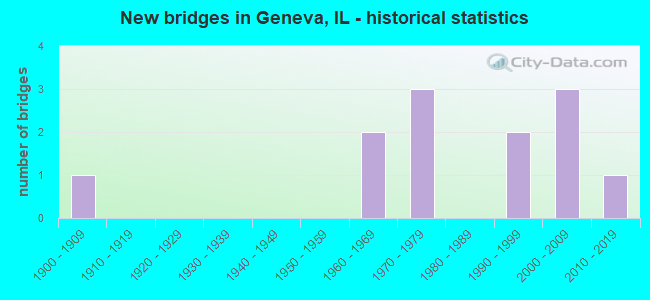
- New bridges - historical statistics
- 11900-1909
- 21960-1969
- 31970-1979
- 21990-1999
- 32000-2009
- 12010-2019

- Reconstructed bridges - Historical Statistics
- 11980-1989
- 11990-1999


- Bridge Condition - Deck
- 11.1%Very good
- 22.2%Good
- 55.6%Satisfactory
- 11.1%Poor

- Bridge Condition - Superstructure
- 30.0%Very good
- 20.0%Good
- 30.0%Satisfactory
- 20.0%Fair

- Bridge Condition - Substructure
- 30.0%Very good
- 50.0%Good
- 20.0%Satisfactory

- Bridge Condition - Channel
- 50.0%Very good
- 33.3%Good
- 16.7%Fair
Find on map >> Show street view
Structure Number: 450046, Location: 0.5 M S OF IL 38 (Lat: 41.882078, Lng: -88.299728), Route carried "on" structure: State highway 25, Year Built: 1965, Year Reconstructed: 2003, Status: Open, Structure Length: 6.01m (19.72ft), Average Daily Traffic: 9,400 (year 2021), Truck Traffic: 4%, Average Future Daily Traffic: 12,122 (year 2032), Design Load: HS 20, Features Intersected: RR - UP
Minimum Vertical Clearance: 30+ m (98+ ft), Kilometerpoint: 24.188, Lanes on structure: 4, Base Highway Network: Yes, Owner: State Highway Agency, Approaching Roadway Width: 17.7m (58.1ft), Skew: 2 degrees, Material/Design: Steel continuous, Design/Construction: Stringer/Multi-beam, Number Of Spans In Main Unit: 3, Length of Maximum Span: 21.7m (71.2ft), Curb or Sidewalk Widths: Left: 1.5m (4.9ft), Right: 1.5m (4.9ft), Curb-To-Curb Width: 17.7m (58.1ft), Out-to-Out Width: 22.2m (72.8ft)
Condition: Deck: Satisfactory, Superstructure: Satisfactory, Substructure: Good, Operating Rating: 75.8 metric tons, Method Used To Determine Operating Rating: Load Factor (LF) rating reported by rating factor (RF) method using MS18 loading, Inventory Rating: 45.7 metric tons, Method Used To Determine Inventory Rating: Load Factor (LF) rating reported by rating factor (RF) method using MS18 loading, Structural Evaluation: Equal to present minimum criteria, Deck Geometry: Somewhat better than minimum adequacy, Underclear: Superior to present desirable criteria, Approach Roadway Alignment: Equal to present desirable criteria, Length Of Structure Improvement: 6.00m (19.69ft), Designated Inspection Frequency: Every 24 months, Inspection Date: January 2021, Bridge Improvement Cost: $1,059,000, Roadway Improvement Cost: $106,000, Total Project Cost: $1,589,000, Deck Structure Type: Concrete Cast-file-Place, Wearing Surface/Protective System: Deck Protection: Epoxy Coated Reinforcing
Find on map >> Show street view
Structure Number: 450079, Location: 0.1 M E OF KAUTZ RD (Lat: 41.882606, Lng: -88.264289), Route carried "on" structure: State highway 38, Year Built: 2014, Status: Open, Structure Length: 7.00m (22.97ft), Average Daily Traffic: 30,200 (year 2021), Truck Traffic: 10%, Average Future Daily Traffic: 41,100 (year 2036), Design Load: HS 25 or greater, Features Intersected: RR - UP
Minimum Vertical Clearance: 30+ m (98+ ft), Kilometerpoint: 111.058, Lanes on structure: 8, Base Highway Network: Yes, Owner: State Highway Agency, Approaching Roadway Width: 25.0m (82.0ft), Skew: 36 degrees, Material/Design: Steel, Design/Construction: Stringer/Multi-beam, Number Of Spans In Main Unit: 1, Length of Maximum Span: 70.0m (229.7ft), Curb or Sidewalk Widths: Left: 3.2m (10.5ft), Right: 3.2m (10.5ft), Curb-To-Curb Width: 25.0m (82.0ft), Out-to-Out Width: 51.8m (169.9ft)
Condition: Deck: Very good, Superstructure: Very good, Substructure: Very good, Operating Rating: 58.0 metric tons, Method Used To Determine Operating Rating: Load and Resistance Factor Rating (LRFR) rating reported by rating factor(RF) method using HL-93 loadings, Inventory Rating: 44.7 metric tons, Method Used To Determine Inventory Rating: Load and Resistance Factor Rating (LRFR) rating reported by rating factor(RF) method using HL-93 loadings, Structural Evaluation: Equal to present desirable criteria, Deck Geometry: High priority of replacement, Underclear: Superior to present desirable criteria, Approach Roadway Alignment: Equal to present desirable criteria, Designated Inspection Frequency: Every 24 months, Inspection Date: July 2020, Deck Structure Type: Concrete Cast-file-Place, Wearing Surface/Protective System: Deck Protection: Epoxy Coated Reinforcing
Find on map >> Show street view
Structure Number: 452014, Location: IL 38 & FOX RIVER (Lat: 41.887297, Lng: -88.303011), Route carried "on" structure: State highway 38, Year Built: 1992, Status: Open, Structure Length: 11.21m (36.78ft), Average Daily Traffic: 23,600 (year 2021), Truck Traffic: 4%, Average Future Daily Traffic: 22,840 (year 2032), Design Load: H 20, Features Intersected: FOX RIVER
Minimum Vertical Clearance: 30.40m (99.74ft), Kilometerpoint: 107.710, Lanes on structure: 4, Base Highway Network: Yes, Owner: State Highway Agency, Approaching Roadway Width: 18.0m (59.1ft), Material/Design: Prestressed concrete continuous, Design/Construction: Stringer/Multi-beam, Number Of Spans In Main Unit: 5, Length of Maximum Span: 26.7m (87.6ft), Curb or Sidewalk Widths: Left: 1.5m (4.9ft), Right: 1.5m (4.9ft), Curb-To-Curb Width: 19.2m (63.0ft), Out-to-Out Width: 23.4m (76.8ft)
Condition: Deck: Good, Superstructure: Satisfactory, Substructure: Good, Channel: Good, Operating Rating: 67.7 metric tons, Method Used To Determine Operating Rating: Load Factor (LF) rating reported by rating factor (RF) method using MS18 loading, Inventory Rating: 41.5 metric tons, Method Used To Determine Inventory Rating: Load Factor (LF) rating reported by rating factor (RF) method using MS18 loading, Structural Evaluation: Equal to present minimum criteria, Deck Geometry: Equal to present minimum criteria, Waterway Adequacy: Equal to present desirable criteria, Approach Roadway Alignment: Equal to present desirable criteria, Designated Inspection Frequency: Every 24 months, Inspection Date: August 2020, Deck Structure Type: Concrete Cast-file-Place, Wearing Surface/Protective System: Wearing Surface: Epoxy Overlay, Deck Protection: Epoxy Coated Reinforcing
Find on map >> Show street view
Structure Number: 453019, Location: .1M W KANENVILLE RD (Lat: 41.864972, Lng: -88.373639), Route carried "on" structure: Other road , Year Built: 2008, Status: Open, Structure Length: 2.89m (9.48ft), Average Daily Traffic: 10,250 (year 2018), Truck Traffic: 6%, Average Future Daily Traffic: 12,760 (year 2032), Design Load: HS 20, Features Intersected: MILL CREEK, Facility Carried by Structure: FABYAN PARKWAY
Minimum Vertical Clearance: 30+ m (98+ ft), Kilometerpoint: 3.186, Lanes on structure: 2, Base Highway Network: Yes, Owner: County Highway Agency, Approaching Roadway Width: 17.1m (56.1ft), Skew: 3 degrees, Material/Design: Steel, Design/Construction: Stringer/Multi-beam, Number Of Spans In Main Unit: 1, Length of Maximum Span: 28.0m (91.9ft), Curb-To-Curb Width: 20.7m (67.9ft), Out-to-Out Width: 21.8m (71.5ft)
Condition: Deck: Good, Superstructure: Very good, Substructure: Very good, Channel: Very good, Operating Rating: 70.6 metric tons, Method Used To Determine Operating Rating: Load Factor (LF) rating reported by rating factor (RF) method using MS18 loading, Inventory Rating: 42.4 metric tons, Method Used To Determine Inventory Rating: Load Factor (LF) rating reported by rating factor (RF) method using MS18 loading, Structural Evaluation: Equal to present desirable criteria, Deck Geometry: Superior to present desirable criteria, Waterway Adequacy: Equal to present desirable criteria, Approach Roadway Alignment: Better than present minimum criteria, Designated Inspection Frequency: Every 48 months, Inspection Date: May 2019, Deck Structure Type: Concrete Cast-file-Place, Wearing Surface/Protective System: Wearing Surface: Integral Concrete, Deck Protection: Epoxy Coated Reinforcing
Find on map >> Show street view
Structure Number: 453028, Location: 1.8 MI SW GENEVA (Lat: 41.881403, Lng: -88.340419), Route carried "on" structure: Other road , Year Built: 1967, Year Reconstructed: 1988, Status: Open, Structure Length: 4.82m (15.81ft), Average Daily Traffic: 39,100 (year 2018), Truck Traffic: 10%, Average Future Daily Traffic: 47,212 (year 2032), Design Load: HS 20, Features Intersected: UNION PACIFIC RR, Facility Carried by Structure: RANDALL ROAD
Minimum Vertical Clearance: 30+ m (98+ ft), Kilometerpoint: 30.512, Lanes on structure: 4, Base Highway Network: Yes, Owner: County Highway Agency, Approaching Roadway Width: 24.4m (80.1ft), Skew: 30 degrees, Material/Design: Steel continuous, Design/Construction: Stringer/Multi-beam, Number Of Spans In Main Unit: 3, Length of Maximum Span: 17.3m (56.8ft), Curb-To-Curb Width: 23.5m (77.1ft), Out-to-Out Width: 25.4m (83.3ft)
Condition: Deck: Satisfactory, Superstructure: Good, Substructure: Satisfactory, Operating Rating: 58.6 metric tons, Method Used To Determine Operating Rating: Load Factor (LF) rating reported by rating factor (RF) method using MS18 loading, Inventory Rating: 35.3 metric tons, Method Used To Determine Inventory Rating: Load Factor (LF) rating reported by rating factor (RF) method using MS18 loading, Structural Evaluation: Equal to present minimum criteria, Deck Geometry: Superior to present desirable criteria, Underclear: Equal to present desirable criteria, Approach Roadway Alignment: Better than present minimum criteria, Designated Inspection Frequency: Every 24 months, Inspection Date: May 2020, Deck Structure Type: Concrete Cast-file-Place, Wearing Surface/Protective System: Wearing Surface: Other, Deck Protection: Epoxy Coated Reinforcing
Find on map >> Show street view
Structure Number: 453096, Location: 1 MI E GENEVA (Lat: 41.882411, Lng: -88.278164), Route carried "on" structure: Other road , Year Built: 1974, Status: Open, Structure Length: 41.95m (137.63ft), Average Daily Traffic: 27,900 (year 2018), Truck Traffic: 9%, Average Future Daily Traffic: 33,048 (year 2032), Design Load: HS 20, Features Intersected: UNION PACIFIC R.R., Facility Carried by Structure: KIRK ROAD
Minimum Vertical Clearance: 30+ m (98+ ft), Kilometerpoint: 30.705, Lanes on structure: 4, Base Highway Network: Yes, Owner: County Highway Agency, Approaching Roadway Width: 21.9m (71.9ft), Skew: 30 degrees, Material/Design: Steel continuous, Design/Construction: Stringer/Multi-beam, Number Of Spans In Main Unit: 18, Length of Maximum Span: 26.5m (86.9ft), Curb-To-Curb Width: 16.9m (55.4ft), Out-to-Out Width: 18.9m (62.0ft)
Condition: Deck: Poor, Superstructure: Fair, Substructure: Satisfactory, Operating Rating: 65.1 metric tons, Method Used To Determine Operating Rating: Load Factor (LF) rating reported by rating factor (RF) method using MS18 loading, Inventory Rating: 38.9 metric tons, Method Used To Determine Inventory Rating: Load Factor (LF) rating reported by rating factor (RF) method using MS18 loading, Structural Evaluation: Somewhat better than minimum adequacy, Deck Geometry: Somewhat better than minimum adequacy, Underclear: Superior to present desirable criteria, Approach Roadway Alignment: Equal to present desirable criteria, Designated Inspection Frequency: Every 24 months, Inspection Date: July 2020, Deck Structure Type: Concrete Cast-file-Place, Wearing Surface/Protective System: Wearing Surface: Other
Find on map >> Show street view
Structure Number: 453097, Location: FABYAN PK W OF IL 25 (Lat: 41.864725, Lng: -88.312217), Route carried "on" structure: Other road , Year Built: 1974, Status: Open, Structure Length: 39.91m (130.94ft), Average Daily Traffic: 28,400 (year 2018), Truck Traffic: 5%, Average Future Daily Traffic: 35,218 (year 2032), Design Load: HS 20, Features Intersected: FOX RIVER, Facility Carried by Structure: FABYAN PARKWAY
Minimum Vertical Clearance: 30+ m (98+ ft), Kilometerpoint: 2.333, Lanes on structure: 4, Base Highway Network: Yes, Owner: County Highway Agency, Approaching Roadway Width: 21.9m (71.9ft), Skew: 30 degrees, Material/Design: Steel continuous, Design/Construction: Stringer/Multi-beam, Number Of Spans In Main Unit: 7, Length of Maximum Span: 85.3m (279.9ft), Curb-To-Curb Width: 16.9m (55.4ft), Out-to-Out Width: 18.9m (62.0ft)
Condition: Deck: Satisfactory, Superstructure: Satisfactory, Substructure: Good, Channel: Very good, Operating Rating: 53.5 metric tons, Method Used To Determine Operating Rating: Load Factor (LF) rating reported by rating factor (RF) method using MS18 loading, Inventory Rating: 32.1 metric tons, Method Used To Determine Inventory Rating: Load Factor (LF) rating reported by rating factor (RF) method using MS18 loading, Structural Evaluation: Equal to present minimum criteria, Deck Geometry: Somewhat better than minimum adequacy, Waterway Adequacy: Superior to present desirable criteria, Approach Roadway Alignment: Better than present minimum criteria, Designated Inspection Frequency: Every 24 months, Underwater Inspection Frequency: Every 60 months, Inspection Date: August 2020, Underwater Inspection Date: August 2020, Deck Structure Type: Concrete Cast-file-Place, Wearing Surface/Protective System: Wearing Surface: Latex Concrete
Find on map >> Show street view
Structure Number: 453145, Location: 0.9 MI W OF PECK RD (Lat: 41.882581, Lng: -88.376481), Route carried "on" structure: County highway , Year Built: 1997, Status: Open, Structure Length: 1.78m (5.84ft), Average Daily Traffic: 7,000 (year 2018), Truck Traffic: 4%, Average Future Daily Traffic: 7,018 (year 2032), Design Load: HS 20, Features Intersected: MILL CREEK, Facility Carried by Structure: KESLINGER RD
Minimum Vertical Clearance: 30+ m (98+ ft), Kilometerpoint: 18.700, Lanes on structure: 2, Base Highway Network: Yes, Owner: County Highway Agency, Approaching Roadway Width: 15.8m (51.8ft), Skew: 2 degrees, Material/Design: Prestressed concrete, Design/Construction: Box Beam or Girders - Multiple, Number Of Spans In Main Unit: 1, Length of Maximum Span: 17.0m (55.8ft), Curb-To-Curb Width: 15.8m (51.8ft), Out-to-Out Width: 15.8m (51.8ft)
Condition: Deck: Satisfactory, Superstructure: Fair, Substructure: Good, Channel: Fair, Operating Rating: 60.3 metric tons, Method Used To Determine Operating Rating: Load Factor (LF) rating reported by rating factor (RF) method using MS18 loading, Inventory Rating: 36.0 metric tons, Method Used To Determine Inventory Rating: Load Factor (LF) rating reported by rating factor (RF) method using MS18 loading, Structural Evaluation: Somewhat better than minimum adequacy, Deck Geometry: Superior to present desirable criteria, Waterway Adequacy: Equal to present desirable criteria, Approach Roadway Alignment: Equal to present desirable criteria, Designated Inspection Frequency: Every 24 months, Inspection Date: April 2021, Deck Structure Type: Concrete Precast Panels, Wearing Surface/Protective System: Wearing Surface: Integral Concrete, Deck Protection: Epoxy Coated Reinforcing
Find on map >> Show street view
Structure Number: 45315, Location: 1W OF RANDALL RD (Lat: 41.882719, Lng: -88.359831), Route carried "on" structure: Other road , Year Built: 2000, Status: Open, Structure Length: 5.26m (17.26ft), Average Daily Traffic: 19,300 (year 2018), Truck Traffic: 4%, Average Future Daily Traffic: 19,860 (year 2032), Design Load: HS 20, Features Intersected: UP RAILROAD, Facility Carried by Structure: KESLINGER RD
Minimum Vertical Clearance: 30+ m (98+ ft), Kilometerpoint: 4.715, Lanes on structure: 4, Base Highway Network: Yes, Owner: County Highway Agency, Approaching Roadway Width: 11.0m (36.1ft), Skew: 6 degrees, Material/Design: Steel, Design/Construction: Stringer/Multi-beam, Number Of Spans In Main Unit: 1, Length of Maximum Span: 50.7m (166.3ft), Curb-To-Curb Width: 13.9m (45.6ft), Out-to-Out Width: 19.9m (65.3ft)
Condition: Deck: Satisfactory, Superstructure: Good, Substructure: Very good, Operating Rating: 58.6 metric tons, Method Used To Determine Operating Rating: Load Factor (LF) rating reported by rating factor (RF) method using MS18 loading, Inventory Rating: 35.0 metric tons, Method Used To Determine Inventory Rating: Load Factor (LF) rating reported by rating factor (RF) method using MS18 loading, Structural Evaluation: Better than present minimum criteria, Deck Geometry: High priority of replacement, Underclear: Equal to present desirable criteria, Approach Roadway Alignment: Equal to present desirable criteria, Designated Inspection Frequency: Every 24 months, Critical Feature Inspection Frequency: Every 24 months, Inspection Date: May 2020, Critical Feature Inspection Date: May 2020, Deck Structure Type: Concrete Cast-file-Place, Wearing Surface/Protective System: Deck Protection: Epoxy Coated Reinforcing
Find on map >> Show street view
Structure Number: 455572, Location: .4 MI E OF RANDALL R (Lat: 41.864442, Lng: -88.333839), Route carried "on" structure: Other road , Year Built: 1974, Status: Open, Structure Length: 0.73m (2.40ft), Average Daily Traffic: 25,900 (year 2018), Truck Traffic: 6%, Average Future Daily Traffic: 29,476 (year 2032), Design Load: HS 20, Features Intersected: BRANCH OF MILL CREEK, Facility Carried by Structure: FABYAN PARKWAY
Minimum Vertical Clearance: 30+ m (98+ ft), Kilometerpoint: 0.547, Lanes on structure: 4, Base Highway Network: Yes, Owner: County Highway Agency, Approaching Roadway Width: 15.8m (51.8ft), Skew: 15 degrees, Material/Design: Concrete, Design/Construction: Culvert, Number Of Spans In Main Unit: 2, Length of Maximum Span: 3.6m (11.8ft), Curb-To-Curb Width: 15.8m (51.8ft), Out-to-Out Width: 22.6m (74.1ft)
Condition: Channel: Very good, Culverts: Satisfactory, Operating Rating: 49.9 metric tons, Method Used To Determine Operating Rating: Load Factor (LF) rating reported by rating factor (RF) method using MS18 loading, Inventory Rating: 29.8 metric tons, Method Used To Determine Inventory Rating: Load Factor (LF) rating reported by rating factor (RF) method using MS18 loading, Structural Evaluation: Equal to present minimum criteria, Deck Geometry: Meets minimum limits, Waterway Adequacy: Equal to present desirable criteria, Approach Roadway Alignment: Equal to present desirable criteria, Designated Inspection Frequency: Every 24 months, Inspection Date: January 2020
Find on map >> Show street view
Structure Number: 459963, Location: .5M S OF KESLINGER (Lat: 41.875239, Lng: -88.375367), Route carried "on" structure: County highway , Year Built: 2009, Status: Open, Structure Length: 1.62m (5.31ft), Average Daily Traffic: 1,300 (year 2018), Truck Traffic: 4%, Average Future Daily Traffic: 829 (year 2032), Design Load: HS 20, Features Intersected: MILL CREEK, Facility Carried by Structure: DOBSON LANE
Minimum Vertical Clearance: 30+ m (98+ ft), Kilometerpoint: 0.451, Lanes on structure: 2, Owner: Town or Township Highway Agency, Approaching Roadway Width: 10.1m (33.1ft), Skew: 1 degrees, Material/Design: Concrete, Design/Construction: Frame, Number Of Spans In Main Unit: 1, Length of Maximum Span: 15.7m (51.5ft), Curb or Sidewalk Widths: Left: 2.4m (7.9ft), Right: 1.2m (3.9ft), Curb-To-Curb Width: 10.1m (33.1ft), Out-to-Out Width: 26.0m (85.3ft)
Condition: Superstructure: Very good, Substructure: Good, Channel: Good, Operating Rating: 54.1 metric tons, Method Used To Determine Operating Rating: Field evaluation and documented engineering judgment, Inventory Rating: 32.4 metric tons, Method Used To Determine Inventory Rating: Field evaluation and documented engineering judgment, Structural Evaluation: Better than present minimum criteria, Deck Geometry: Somewhat better than minimum adequacy, Waterway Adequacy: Equal to present desirable criteria, Approach Roadway Alignment: Equal to present desirable criteria, Designated Inspection Frequency: Every 48 months, Inspection Date: May 2021, Deck Structure Type: Other
Find on map >> Show street view
Structure Number: 450069, Location: .4 M S OF ILL 38 (Lat: 41.881608, Lng: -88.307061), Route carried "under" structure: State highway 31, Year Built: 1900, Structure Length: 0. m, Average Daily Traffic: 7,150 (year 2021), Truck Traffic: 3%, Features Intersected: ILL 31 (BATAVIA AVE), Facility Carried by Structure: UP RR
Minimum Vertical Clearance: 4.80m (15.75ft), Kilometerpoint: 23.705, Lanes under structure: 2, Material/Design: Steel, Design/Construction: Girder and Floorbeam System, Length of Maximum Span: 14.3m (46.9ft)