Bridge Statistics for Garden Acres, California (CA)
Condition, Traffic, Stress, Structural Evaluation, Project Costs
- National Bridge Inventory (NBI) Statistics
- 11Number of bridges
- 138ft / 42.0mTotal length
- 339,085Total average daily traffic
- 40,343Total average daily truck traffic
- National Bridge Inventory (NBI) Registered Bridges for Garden Acres
- No street view available for this location
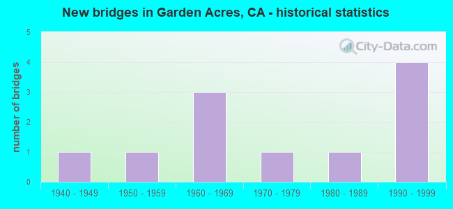
- New bridges - historical statistics
- 11940-1949
- 11950-1959
- 31960-1969
- 11970-1979
- 11980-1989
- 41990-1999

- Reconstructed bridges - Historical Statistics
- 11970-1979
- 11980-1989
- 01990-1999
- 12000-2009
- 12010-2019


- Bridge Condition - Deck
- 66.7%Good
- 16.7%Satisfactory
- 16.7%Fair

- Bridge Condition - Superstructure
- 50.0%Good
- 33.3%Satisfactory
- 16.7%Fair

- Bridge Condition - Substructure
- 83.3%Good
- 16.7%Fair

- Bridge Condition - Channel
- 40.0%Very good
- 20.0%Good
- 40.0%Satisfactory
Find on map >> Show street view
Structure Number: 29 004, Location: 10-SJ-026-1.90 (Lat: 37.973947, Lng: -121.231958), Route carried "on" structure: State highway 26, Year Built: 1967, Year Reconstructed: 1988, Status: Open, Structure Length: 8.78m (28.81ft), Average Daily Traffic: 10,200 (year 2009), Truck Traffic: 9%, Average Future Daily Traffic: 17,952 (year 2039), Design Load: HS 20+Mod, Features Intersected: STOCKTON DIVERTING CANAL
Minimum Vertical Clearance: 30+ m (98+ ft), Kilometerpoint: 1.900, Lanes on structure: 2, Base Highway Network: Yes (, Subroute: 1), Owner: State Highway Agency, Approaching Roadway Width: 16.9m (55.4ft), Skew: 4 degrees, Material/Design: Concrete continuous, Design/Construction: Slab, Number Of Spans In Main Unit: 10, Length of Maximum Span: 9.1m (29.9ft), Curb or Sidewalk Widths: Left: 1.5m (4.9ft), Right: 0.0m, Curb-To-Curb Width: 16.9m (55.4ft), Out-to-Out Width: 19.3m (63.3ft)
Condition: Deck: Good, Superstructure: Good, Substructure: Fair, Channel: Satisfactory, Operating Rating: 53.1 metric tons, Method Used To Determine Operating Rating: Load Factor (LF), Inventory Rating: 31.8 metric tons, Method Used To Determine Inventory Rating: Load Factor (LF), Structural Evaluation: Somewhat better than minimum adequacy, Deck Geometry: Superior to present desirable criteria, Waterway Adequacy: Equal to present desirable criteria, Approach Roadway Alignment: Equal to present desirable criteria, Designated Inspection Frequency: Every 24 months, Inspection Date: March 2021, Deck Structure Type: Concrete Cast-file-Place
Find on map >> Show street view
Structure Number: 29 0053, Location: 10-SJ-004-R22.72 (Lat: 37.949228, Lng: -121.182311), Route carried "on" structure: State highway 4, Year Built: 1951, Year Reconstructed: 1977, Status: Open, Structure Length: 0.79m (2.59ft), Average Daily Traffic: 4,550 (year 2009), Average Future Daily Traffic: 9,679 (year 2039), Features Intersected: DUCK CREEK
Minimum Vertical Clearance: 30+ m (98+ ft), Kilometerpoint: 22.720, Lanes on structure: 2, Base Highway Network: Yes (, Subroute: 1), Owner: State Highway Agency, Approaching Roadway Width: 11.9m (39.0ft), Material/Design: Concrete continuous, Design/Construction: Culvert, Number Of Spans In Main Unit: 2, Length of Maximum Span: 3.7m (12.1ft), Curb-To-Curb Width: 12.0m (39.4ft), Out-to-Out Width: 15.9m (52.2ft)
Condition: Channel: Very good, Culverts: Satisfactory, Operating Rating: 54.1 metric tons, Method Used To Determine Operating Rating: Field evaluation and documented engineering judgment, Inventory Rating: 32.4 metric tons, Method Used To Determine Inventory Rating: Field evaluation and documented engineering judgment, Structural Evaluation: Equal to present minimum criteria, Deck Geometry: Somewhat better than minimum adequacy, Waterway Adequacy: Equal to present desirable criteria, Approach Roadway Alignment: Equal to present minimum criteria, Length Of Structure Improvement: 0.79m (2.59ft), Designated Inspection Frequency: Every 24 months, Inspection Date: August 2021
Find on map >> Show street view
Structure Number: 29 0119, Location: 10-SJ-099-17.76 (Lat: 37.948931, Lng: -121.236792), Route carried "on" structure: State highway 99, Year Built: 1949, Year Reconstructed: 2016, Status: Open, Structure Length: 3.14m (10.30ft), Average Daily Traffic: 87,000 (year 2009), Truck Traffic: 13%, Average Future Daily Traffic: 133,659 (year 2040), Design Load: HS 20, Features Intersected: MORMON SLOUGH
Minimum Vertical Clearance: 30+ m (98+ ft), Kilometerpoint: 17.760, Lanes on structure: 8, Base Highway Network: Yes (, Subroute: 1), Owner: State Highway Agency, Approaching Roadway Width: 45.5m (149.3ft), Skew: 33 degrees, Material/Design: Concrete continuous, Design/Construction: Slab, Number Of Spans In Main Unit: 4, Length of Maximum Span: 8.5m (27.9ft), Curb-To-Curb Width: 45.5m (149.3ft), Out-to-Out Width: 47.0m (154.2ft)
Condition: Deck: Good, Superstructure: Good, Substructure: Good, Channel: Good, Operating Rating: 47.0 metric tons, Method Used To Determine Operating Rating: Load Factor (LF), Inventory Rating: 28.5 metric tons, Method Used To Determine Inventory Rating: Load Factor (LF), Structural Evaluation: Better than present minimum criteria, Deck Geometry: Superior to present desirable criteria, Waterway Adequacy: Better than present minimum criteria, Approach Roadway Alignment: Equal to present desirable criteria, Length Of Structure Improvement: 3.14m (10.30ft), Designated Inspection Frequency: Every 24 months, Inspection Date: June 2020, Deck Structure Type: Concrete Cast-file-Place, Wearing Surface/Protective System: Wearing Surface: Integral Concrete
Find on map >> Show street view
Structure Number: 29 0142, Location: 10-SJ-026-1.11 (Lat: 37.969728, Lng: -121.245958), Route carried "on" structure: State highway 26, Year Built: 1961, Year Reconstructed: 2007, Status: Open, Structure Length: 4.20m (13.78ft), Average Daily Traffic: 16,100 (year 2009), Truck Traffic: 11%, Average Future Daily Traffic: 28,725 (year 2039), Design Load: HS 20, Features Intersected: STATE ROUTE 99 AND RAMPS
Minimum Vertical Clearance: 30+ m (98+ ft), Kilometerpoint: 1.110, Lanes on structure: 5, Lanes under structure: 8, Base Highway Network: Yes (, Subroute: 1), Owner: State Highway Agency, Approaching Roadway Width: 24.0m (78.7ft), Material/Design: Steel, Design/Construction: Stringer/Multi-beam, Number Of Spans In Main Unit: 2, Length of Maximum Span: 20.4m (66.9ft), Curb or Sidewalk Widths: Left: 1.5m (4.9ft), Right: 0.0m, Curb-To-Curb Width: 24.0m (78.7ft), Out-to-Out Width: 26.3m (86.3ft)
Condition: Deck: Good, Superstructure: Satisfactory, Substructure: Good, Operating Rating: 36.0 metric tons, Method Used To Determine Operating Rating: Load and Resistance Factor Rating (LRFR) rating reported by rating factor(RF) method using HL-93 loadings, Inventory Rating: 27.9 metric tons, Method Used To Determine Inventory Rating: Load and Resistance Factor Rating (LRFR) rating reported by rating factor(RF) method using HL-93 loadings, Structural Evaluation: Equal to present minimum criteria, Deck Geometry: Equal to present desirable criteria, Underclear: High priority of corrective action, Approach Roadway Alignment: Equal to present desirable criteria, Designated Inspection Frequency: Every 24 months, Inspection Date: March 2021, Deck Structure Type: Concrete Cast-file-Place, Wearing Surface/Protective System: Wearing Surface: Bituminous
Find on map >> Show street view
Structure Number: 29 0309G, Location: 10-SJ-099-18.57 (Lat: 37.960472, Lng: -121.240783), Route carried "on" structure: Ramp State highway 99, Year Built: 1993, Status: Open, Structure Length: 20.82m (68.31ft), Average Daily Traffic: 16,000 (year 2009), Truck Traffic: 10%, Average Future Daily Traffic: 17,388 (year 2040), Design Load: HS 20+Mod, Features Intersected: SR 99, E4-N99, N99-E26
Minimum Vertical Clearance: 30+ m (98+ ft), Kilometerpoint: 18.570, Lanes on structure: 2, Lanes under structure: 12, Owner: State Highway Agency, Approaching Roadway Width: 12.2m (40.0ft), Material/Design: Prestressed concrete continuous, Design/Construction: Box Beam or Girders - Multiple, Number Of Spans In Main Unit: 6, Length of Maximum Span: 42.0m (137.8ft), Curb-To-Curb Width: 11.9m (39.0ft), Out-to-Out Width: 13.0m (42.7ft)
Condition: Deck: Good, Superstructure: Good, Substructure: Good, Operating Rating: 54.1 metric tons, Method Used To Determine Operating Rating: Assigned rating based on Load Factor Design (LFD) reported in metric tons, Inventory Rating: 32.4 metric tons, Method Used To Determine Inventory Rating: Assigned rating based on Load Factor Design (LFD) reported in metric tons, Structural Evaluation: Better than present minimum criteria, Deck Geometry: Superior to present desirable criteria, Underclear: Equal to present minimum criteria, Approach Roadway Alignment: Better than present minimum criteria, Designated Inspection Frequency: Every 24 months, Inspection Date: June 2020, Deck Structure Type: Concrete Cast-file-Place
Find on map >> Show street view
Structure Number: 29C0103, Location: 0.3 MI S MAIN ST (Lat: 37.953192, Lng: -121.221183), Route carried "on" structure: County highway , Year Built: 1974, Status: Open, Structure Length: 2.19m (7.19ft), Average Daily Traffic: 1,615 (year 2017), Truck Traffic: 10%, Average Future Daily Traffic: 2,050 (year 2039), Design Load: HS 20, Features Intersected: MORMON SLOUGH, Facility Carried by Structure: WALKER LANE
Minimum Vertical Clearance: 30+ m (98+ ft), Kilometerpoint: 0.000, Lanes on structure: 2, Owner: County Highway Agency, Approaching Roadway Width: 6.7m (22.0ft), Skew: 1 degrees, Material/Design: Concrete continuous, Design/Construction: Slab, Number Of Spans In Main Unit: 3, Length of Maximum Span: 8.5m (27.9ft), Curb-To-Curb Width: 12.2m (40.0ft), Out-to-Out Width: 12.4m (40.7ft)
Condition: Deck: Fair, Superstructure: Fair, Substructure: Good, Channel: Satisfactory, Operating Rating: 76.1 metric tons, Method Used To Determine Operating Rating: Load Factor (LF), Inventory Rating: 45.7 metric tons, Method Used To Determine Inventory Rating: Load Factor (LF), Structural Evaluation: Somewhat better than minimum adequacy, Deck Geometry: Better than present minimum criteria, Waterway Adequacy: Equal to present desirable criteria, Approach Roadway Alignment: Equal to present desirable criteria, Designated Inspection Frequency: Every 24 months, Inspection Date: January 2021, Deck Structure Type: Concrete Cast-file-Place, Wearing Surface/Protective System: Wearing Surface: Bituminous
Find on map >> Show street view
Structure Number: 29C0338, Location: 0.3 MI SOUTH MAIN ST (Lat: 37.950150, Lng: -121.232544), Route carried "on" structure: County highway , Year Built: 1988, Status: Open, Structure Length: 2.07m (6.79ft), Average Daily Traffic: 4,300 (year 2017), Truck Traffic: 2%, Average Future Daily Traffic: 5,879 (year 2039), Design Load: HS 20+Mod, Features Intersected: MORMON SLOUGH, Facility Carried by Structure: ORO AVENUE
Minimum Vertical Clearance: 30+ m (98+ ft), Kilometerpoint: 0.000, Lanes on structure: 2, Owner: County Highway Agency, Approaching Roadway Width: 13.4m (44.0ft), Material/Design: Concrete continuous, Design/Construction: Slab, Number Of Spans In Main Unit: 3, Length of Maximum Span: 7.9m (25.9ft), Curb or Sidewalk Widths: Left: 1.5m (4.9ft), Right: 1.5m (4.9ft), Curb-To-Curb Width: 13.4m (44.0ft), Out-to-Out Width: 17.1m (56.1ft)
Condition: Deck: Satisfactory, Superstructure: Satisfactory, Substructure: Good, Channel: Very good, Operating Rating: 54.1 metric tons, Method Used To Determine Operating Rating: Assigned rating based on Load Factor Design (LFD) reported in metric tons, Inventory Rating: 32.4 metric tons, Method Used To Determine Inventory Rating: Assigned rating based on Load Factor Design (LFD) reported in metric tons, Structural Evaluation: Equal to present minimum criteria, Deck Geometry: Better than present minimum criteria, Waterway Adequacy: Equal to present desirable criteria, Approach Roadway Alignment: Equal to present desirable criteria, Designated Inspection Frequency: Every 48 months, Inspection Date: January 2019, Deck Structure Type: Concrete Cast-file-Place
Find on map >> Show street view
Structure Number: 29 0142, Location: 10-SJ-026-1.11 (Lat: 37.969728, Lng: -121.245958), Route carried "under" structure: State highway 99, Year Built: 1961, Structure Length: 0. m, Average Daily Traffic: 83,000 (year 2009), Truck Traffic: 13%, Features Intersected: STATE ROUTE 99 AND RAMPS, Facility Carried by Structure: STATE ROUTE 26
Minimum Vertical Clearance: 4.57m (14.99ft), Kilometerpoint: 19.290, Lanes on structure: 5, Lanes under structure: 8, Material/Design: Steel, Design/Construction: Stringer/Multi-beam, Length of Maximum Span: 20.4m (66.9ft)
Find on map >> Show street view
Structure Number: 29 0309G, Location: 10-SJ-099-18.57 (Lat: 37.960472, Lng: -121.240783), Route carried "under" structure: State highway 99, Year Built: 1993, Structure Length: 0. m, Average Daily Traffic: 96,000 (year 2009), Truck Traffic: 13%, Features Intersected: SR 99, E4-N99, N99-E26
Minimum Vertical Clearance: 12.32m (40.42ft), Kilometerpoint: 18.570, Lanes on structure: 2, Lanes under structure: 9, Material/Design: Prestressed concrete continuous, Design/Construction: Box Beam or Girders - Multiple, Length of Maximum Span: 42.0m (137.8ft)
Find on map >> Show street view
Structure Number: 29 0309G, Location: 10-SJ-099-18.57 (Lat: 37.960472, Lng: -121.240783), Route carried "under" structure: Ramp State highway 4, Year Built: 1993, Structure Length: 0. m, Average Daily Traffic: 18,400 (year 2006), Truck Traffic: 5%, Features Intersected: SR 99, E4-N99, N99-E26
Minimum Vertical Clearance: 5.49m (18.01ft), Kilometerpoint: 19.440, Lanes on structure: 2, Lanes under structure: 2, Material/Design: Prestressed concrete continuous, Design/Construction: Box Beam or Girders - Multiple, Length of Maximum Span: 42.0m (137.8ft)
Find on map >> Show street view
Structure Number: 29 0309G, Location: 10-SJ-099-18.57 (Lat: 37.960472, Lng: -121.240783), Route carried "under" structure: Ramp State highway 99, Year Built: 1993, Structure Length: 0. m, Average Daily Traffic: 1,920 (year 2009), Truck Traffic: 16%, Features Intersected: SR 99, E4-N99, N99-E26
Minimum Vertical Clearance: 10.41m (34.15ft), Kilometerpoint: 18.570, Lanes on structure: 2, Lanes under structure: 1, Material/Design: Prestressed concrete continuous, Design/Construction: Box Beam or Girders - Multiple, Length of Maximum Span: 42.0m (137.8ft)