Bridge Statistics for Franklin, California (CA)
Condition, Traffic, Stress, Structural Evaluation, Project Costs
- National Bridge Inventory (NBI) Statistics
- 14Number of bridges
- 131ft / 40.5mTotal length
- 192,098Total average daily traffic
- 35,599Total average daily truck traffic
- National Bridge Inventory (NBI) Registered Bridges for Franklin
- No street view available for this location
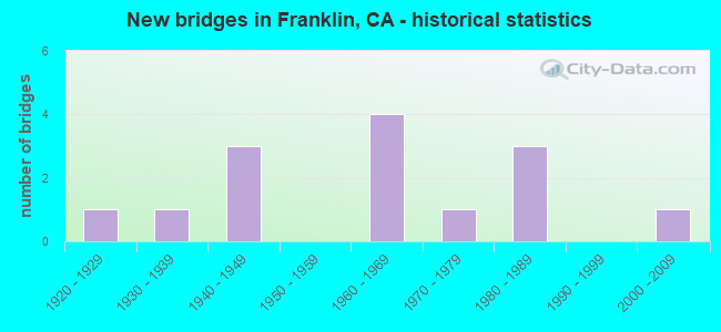
- New bridges - historical statistics
- 11920-1929
- 11930-1939
- 31940-1949
- 41960-1969
- 11970-1979
- 31980-1989
- 12000-2009

- Reconstructed bridges - Historical Statistics
- 11920-1929
- 01930-1939
- 01940-1949
- 01950-1959
- 31960-1969


- Bridge Condition - Deck
- 58.3%Good
- 25.0%Satisfactory
- 16.7%Fair

- Bridge Condition - Superstructure
- 66.7%Good
- 16.7%Satisfactory
- 16.7%Fair

- Bridge Condition - Substructure
- 33.3%Good
- 16.7%Satisfactory
- 50.0%Fair

- Bridge Condition - Channel
- 25.0%Excellent
- 33.3%Very good
- 25.0%Good
- 16.7%Satisfactory
Find on map >> Show street view
Structure Number: 24 0327R, Location: 03-SAC-005-8.11 (Lat: 38.369914, Lng: -121.475419), Route carried "on" structure: Interstate 5, Year Built: 1975, Status: Open, Structure Length: 2.68m (8.79ft), Average Daily Traffic: 27,000 (year 2015), Truck Traffic: 21%, Average Future Daily Traffic: 54,761 (year 2040), Design Load: HS 20, Features Intersected: STONE LAKE CREEK
Minimum Vertical Clearance: 30+ m (98+ ft), Kilometerpoint: 8.110, Lanes on structure: 2, Base Highway Network: Yes (, Subroute: 1), Owner: State Highway Agency, Approaching Roadway Width: 11.9m (39.0ft), Material/Design: Concrete continuous, Design/Construction: Tee Beam, Number Of Spans In Main Unit: 2, Length of Maximum Span: 13.1m (43.0ft), Curb-To-Curb Width: 12.2m (40.0ft), Out-to-Out Width: 12.8m (42.0ft)
Condition: Deck: Good, Superstructure: Good, Substructure: Good, Channel: Excellent, Operating Rating: 60.3 metric tons, Method Used To Determine Operating Rating: Load and Resistance Factor Rating (LRFR) rating reported by rating factor(RF) method using HL-93 loadings, Inventory Rating: 46.3 metric tons, Method Used To Determine Inventory Rating: Load and Resistance Factor Rating (LRFR) rating reported by rating factor(RF) method using HL-93 loadings, Structural Evaluation: Better than present minimum criteria, Deck Geometry: Better than present minimum criteria, Waterway Adequacy: Equal to present desirable criteria, Approach Roadway Alignment: Equal to present desirable criteria, Designated Inspection Frequency: Every 24 months, Inspection Date: May 2020, Deck Structure Type: Concrete Cast-file-Place
Find on map >> Show street view
Structure Number: 24C0153, Location: 3.2 MI N LAMBERT RD (Lat: 38.366133, Lng: -121.453903), Route carried "on" structure: County highway , Year Built: 1925, Year Reconstructed: 1933, Status: Open, Structure Length: 1.98m (6.50ft), Average Daily Traffic: 2,346 (year 2009), Truck Traffic: 10%, Average Future Daily Traffic: 2,936 (year 2039), Features Intersected: STONE LAKE DRAIN, Facility Carried by Structure: FRANKLIN BLVD
Minimum Vertical Clearance: 30+ m (98+ ft), Kilometerpoint: 0.000, Lanes on structure: 2, Owner: County Highway Agency, Approaching Roadway Width: 10.1m (33.1ft), Material/Design: Concrete continuous, Design/Construction: Slab, Number Of Spans In Main Unit: 4, Length of Maximum Span: 4.9m (16.1ft), Curb or Sidewalk Widths: Left: 0.6m (2.0ft), Right: 0.6m (2.0ft), Curb-To-Curb Width: 10.7m (35.1ft), Out-to-Out Width: 12.3m (40.4ft)
Condition: Deck: Good, Superstructure: Good, Substructure: Fair, Channel: Satisfactory, Operating Rating: 27.5 metric tons, Method Used To Determine Operating Rating: Field evaluation and documented engineering judgment, Inventory Rating: 16.5 metric tons, Method Used To Determine Inventory Rating: Field evaluation and documented engineering judgment, Structural Evaluation: Meets minimum limits, Deck Geometry: Somewhat better than minimum adequacy, Waterway Adequacy: Equal to present minimum criteria, Approach Roadway Alignment: Equal to present desirable criteria, Designated Inspection Frequency: Every 24 months, Inspection Date: October 2020, Deck Structure Type: Concrete Cast-file-Place, Wearing Surface/Protective System: Wearing Surface: Bituminous
Find on map >> Show street view
Structure Number: 24C0156, Location: 0.4 MI N HOOD-FRANKLIN RD (Lat: 38.383119, Lng: -121.453967), Route carried "on" structure: County highway , Year Built: 1933, Status: Open, Structure Length: 1.16m (3.81ft), Average Daily Traffic: 2,346 (year 2009), Truck Traffic: 10%, Average Future Daily Traffic: 2,971 (year 2039), Features Intersected: DRAINAGE DITCH, Facility Carried by Structure: FRANKLIN BLVD
Minimum Vertical Clearance: 30+ m (98+ ft), Kilometerpoint: 0.000, Lanes on structure: 2, Owner: County Highway Agency, Approaching Roadway Width: 11.0m (36.1ft), Material/Design: Concrete continuous, Design/Construction: Slab, Number Of Spans In Main Unit: 3, Length of Maximum Span: 4.0m (13.1ft), Curb-To-Curb Width: 9.1m (29.9ft), Out-to-Out Width: 10.1m (33.1ft)
Condition: Deck: Good, Superstructure: Good, Substructure: Fair, Channel: Satisfactory, Operating Rating: 53.5 metric tons, Method Used To Determine Operating Rating: Load Factor (LF), Inventory Rating: 32.1 metric tons, Method Used To Determine Inventory Rating: Load Factor (LF), Structural Evaluation: Somewhat better than minimum adequacy, Deck Geometry: Meets minimum limits, Waterway Adequacy: Equal to present minimum criteria, Approach Roadway Alignment: Equal to present desirable criteria, Designated Inspection Frequency: Every 24 months, Inspection Date: October 2020, Deck Structure Type: Concrete Cast-file-Place, Wearing Surface/Protective System: Wearing Surface: Bituminous
Find on map >> Show street view
Structure Number: 24C0547, Location: 0.4 MI N HOOD-FRANKLIN RD (Lat: 38.383333, Lng: -121.453897), Route carried "on" structure: County highway , Year Built: 2008, Status: Open, Structure Length: 1.97m (6.46ft), Average Daily Traffic: 2,300 (year 2007), Truck Traffic: 10%, Average Future Daily Traffic: 2,844 (year 2042), Features Intersected: DRAINAGE DTCH (FRANKLIN), Facility Carried by Structure: FRANKLIN BLVD
Minimum Vertical Clearance: 30+ m (98+ ft), Kilometerpoint: 0.000, Lanes on structure: 2, Owner: County Highway Agency, Approaching Roadway Width: 9.1m (29.9ft), Material/Design: Concrete continuous, Design/Construction: Culvert, Number Of Spans In Main Unit: 5, Length of Maximum Span: 3.7m (12.1ft), Curb or Sidewalk Widths: Left: 1.2m (3.9ft), Right: 1.2m (3.9ft), Curb-To-Curb Width: 14.6m (47.9ft), Out-to-Out Width: 17.7m (58.1ft)
Condition: Channel: Excellent, Culverts: Good, Operating Rating: 54.1 metric tons, Method Used To Determine Operating Rating: Field evaluation and documented engineering judgment, Inventory Rating: 32.4 metric tons, Method Used To Determine Inventory Rating: Field evaluation and documented engineering judgment, Structural Evaluation: Better than present minimum criteria, Deck Geometry: Superior to present desirable criteria, Waterway Adequacy: Somewhat better than minimum adequacy, Approach Roadway Alignment: Equal to present desirable criteria, Designated Inspection Frequency: Every 48 months, Inspection Date: October 2020, Deck Structure Type: Concrete Cast-file-Place, Wearing Surface/Protective System: Wearing Surface: Bituminous
Find on map >> Show street view
Structure Number: 39 0016R, Location: 10-MER-099-18.06 (Lat: 37.318978, Lng: -120.535331), Route carried "on" structure: State highway 99, Year Built: 1947, Year Reconstructed: 1974, Status: Open, Structure Length: 2.84m (9.32ft), Average Daily Traffic: 28,000 (year 2009), Truck Traffic: 20%, Average Future Daily Traffic: 42,082 (year 2040), Design Load: HS 20, Features Intersected: FRANKLIN SLOUGH
Minimum Vertical Clearance: 30+ m (98+ ft), Kilometerpoint: 18.060, Lanes on structure: 2, Base Highway Network: Yes (, Subroute: 1), Owner: State Highway Agency, Approaching Roadway Width: 11.0m (36.1ft), Material/Design: Concrete continuous, Design/Construction: Slab, Number Of Spans In Main Unit: 5, Length of Maximum Span: 6.1m (20.0ft), Curb-To-Curb Width: 10.7m (35.1ft), Out-to-Out Width: 10.9m (35.8ft)
Condition: Deck: Good, Superstructure: Good, Substructure: Good, Channel: Very good, Operating Rating: 46.0 metric tons, Method Used To Determine Operating Rating: Load Factor (LF), Inventory Rating: 27.5 metric tons, Method Used To Determine Inventory Rating: Load Factor (LF), Structural Evaluation: Equal to present minimum criteria, Deck Geometry: Meets minimum limits, Waterway Adequacy: Equal to present desirable criteria, Approach Roadway Alignment: Equal to present desirable criteria, Designated Inspection Frequency: Every 24 months, Inspection Date: April 2020, Deck Structure Type: Concrete Cast-file-Place, Wearing Surface/Protective System: Wearing Surface: Bituminous
Find on map >> Show street view
Structure Number: 39 0084, Location: 10-MER-099-18.51 (Lat: 37.321078, Lng: -120.543128), Route carried "on" structure: County highway , Year Built: 1962, Status: Open, Structure Length: 9.76m (32.02ft), Average Daily Traffic: 700 (year 1998), Truck Traffic: 5%, Average Future Daily Traffic: 2,173 (year 2040), Design Load: HS 20, Features Intersected: STATE ROUTE 99, Facility Carried by Structure: FRANKLIN RD
Minimum Vertical Clearance: 30+ m (98+ ft), Kilometerpoint: 0.000, Lanes on structure: 2, Lanes under structure: 5, Base Highway Network: Yes, Owner: State Highway Agency, Approaching Roadway Width: 10.7m (35.1ft), Material/Design: Steel, Design/Construction: Stringer/Multi-beam, Number Of Spans In Main Unit: 5, Length of Maximum Span: 25.9m (85.0ft), Curb or Sidewalk Widths: Left: 0.6m (2.0ft), Right: 0.6m (2.0ft), Curb-To-Curb Width: 8.5m (27.9ft), Out-to-Out Width: 10.4m (34.1ft)
Condition: Deck: Satisfactory, Superstructure: Good, Substructure: Good, Operating Rating: 51.5 metric tons, Method Used To Determine Operating Rating: Load Factor (LF), Inventory Rating: 30.8 metric tons, Method Used To Determine Inventory Rating: Load Factor (LF), Structural Evaluation: Better than present minimum criteria, Deck Geometry: Somewhat better than minimum adequacy, Underclear: Equal to present minimum criteria, Approach Roadway Alignment: Better than present minimum criteria, Designated Inspection Frequency: Every 24 months, Inspection Date: April 2020, Deck Structure Type: Concrete Cast-file-Place
Find on map >> Show street view
Structure Number: 39 0116L, Location: 10-MER-099-18.59 (Lat: 37.322053, Lng: -120.544258), Route carried "on" structure: State highway 99, Year Built: 1947, Year Reconstructed: 1974, Status: Open, Structure Length: 2.84m (9.32ft), Average Daily Traffic: 28,000 (year 2009), Truck Traffic: 20%, Average Future Daily Traffic: 42,222 (year 2041), Design Load: HS 20, Features Intersected: ASHE DRAIN
Minimum Vertical Clearance: 30+ m (98+ ft), Kilometerpoint: 18.590, Lanes on structure: 2, Base Highway Network: Yes (, Subroute: 1), Owner: State Highway Agency, Approaching Roadway Width: 10.1m (33.1ft), Material/Design: Concrete continuous, Design/Construction: Slab, Number Of Spans In Main Unit: 5, Length of Maximum Span: 6.1m (20.0ft), Curb-To-Curb Width: 10.7m (35.1ft), Out-to-Out Width: 10.9m (35.8ft)
Condition: Deck: Satisfactory, Superstructure: Satisfactory, Substructure: Satisfactory, Channel: Good, Operating Rating: 45.7 metric tons, Method Used To Determine Operating Rating: Load Factor (LF), Inventory Rating: 27.5 metric tons, Method Used To Determine Inventory Rating: Load Factor (LF), Structural Evaluation: Equal to present minimum criteria, Deck Geometry: Meets minimum limits, Waterway Adequacy: Better than present minimum criteria, Approach Roadway Alignment: Equal to present desirable criteria, Designated Inspection Frequency: Every 24 months, Inspection Date: December 2021, Deck Structure Type: Concrete Cast-file-Place, Wearing Surface/Protective System: Wearing Surface: Bituminous
Find on map >> Show street view
Structure Number: 39 0116R, Location: 10-MER-099-18.59 (Lat: 37.322206, Lng: -120.544086), Route carried "on" structure: State highway 99, Year Built: 1947, Year Reconstructed: 1974, Status: Open, Structure Length: 2.84m (9.32ft), Average Daily Traffic: 28,000 (year 2009), Truck Traffic: 20%, Average Future Daily Traffic: 42,222 (year 2041), Design Load: HS 20, Features Intersected: ASHE DRAIN
Minimum Vertical Clearance: 30+ m (98+ ft), Kilometerpoint: 18.590, Lanes on structure: 2, Base Highway Network: Yes (, Subroute: 1), Owner: State Highway Agency, Approaching Roadway Width: 11.0m (36.1ft), Material/Design: Concrete continuous, Design/Construction: Slab, Number Of Spans In Main Unit: 5, Length of Maximum Span: 6.1m (20.0ft), Curb-To-Curb Width: 10.7m (35.1ft), Out-to-Out Width: 10.9m (35.8ft)
Condition: Deck: Satisfactory, Superstructure: Satisfactory, Substructure: Satisfactory, Channel: Good, Operating Rating: 45.7 metric tons, Method Used To Determine Operating Rating: Load Factor (LF), Inventory Rating: 27.5 metric tons, Method Used To Determine Inventory Rating: Load Factor (LF), Structural Evaluation: Equal to present minimum criteria, Deck Geometry: Meets minimum limits, Waterway Adequacy: Better than present minimum criteria, Approach Roadway Alignment: Equal to present desirable criteria, Designated Inspection Frequency: Every 24 months, Inspection Date: December 2021, Deck Structure Type: Concrete Cast-file-Place, Wearing Surface/Protective System: Wearing Surface: Bituminous
Find on map >> Show street view
Structure Number: 39C0024, Location: 0.12 MI NW OF AVENUE TWO (Lat: 37.350842, Lng: -120.557508), Route carried "on" structure: County highway , Year Built: 1985, Status: Open, Structure Length: 2.83m (9.28ft), Average Daily Traffic: 10,676 (year 2000), Truck Traffic: 6%, Average Future Daily Traffic: 18,576 (year 2042), Design Load: HS 20, Features Intersected: CANAL CREEK, Facility Carried by Structure: SANTA FE DRIVE
Minimum Vertical Clearance: 30+ m (98+ ft), Kilometerpoint: 0.000, Lanes on structure: 4, Base Highway Network: Yes, Owner: County Highway Agency, Approaching Roadway Width: 23.2m (76.1ft), Skew: 20 degrees, Material/Design: Concrete continuous, Design/Construction: Slab, Number Of Spans In Main Unit: 3, Length of Maximum Span: 9.1m (29.9ft), Curb-To-Curb Width: 23.2m (76.1ft), Out-to-Out Width: 24.2m (79.4ft)
Condition: Deck: Good, Superstructure: Good, Substructure: Good, Channel: Very good, Operating Rating: 85.2 metric tons, Method Used To Determine Operating Rating: Load Factor (LF), Inventory Rating: 51.2 metric tons, Method Used To Determine Inventory Rating: Load Factor (LF), Structural Evaluation: Better than present minimum criteria, Deck Geometry: Superior to present desirable criteria, Waterway Adequacy: Equal to present desirable criteria, Approach Roadway Alignment: Equal to present desirable criteria, Designated Inspection Frequency: Every 48 months, Inspection Date: January 2020, Deck Structure Type: Concrete Cast-file-Place
Find on map >> Show street view
Structure Number: 39C0037, Location: 0.3 MI S BEACHWOOD RD (Lat: 37.314728, Lng: -120.523222), Route carried "on" structure: County highway , Year Built: 1962, Status: Open, Structure Length: 3.05m (10.01ft), Average Daily Traffic: 3,063 (year 2005), Truck Traffic: 6%, Average Future Daily Traffic: 3,323 (year 2039), Features Intersected: BLACK RASCAL CREEK, Facility Carried by Structure: ASHBY ROAD
Minimum Vertical Clearance: 30+ m (98+ ft), Kilometerpoint: 0.000, Lanes on structure: 2, Owner: County Highway Agency, Approaching Roadway Width: 7.9m (25.9ft), Skew: 2 degrees, Material/Design: Concrete continuous, Design/Construction: Slab, Number Of Spans In Main Unit: 4, Length of Maximum Span: 8.5m (27.9ft), Curb or Sidewalk Widths: Left: 0.6m (2.0ft), Right: 0.6m (2.0ft), Curb-To-Curb Width: 8.5m (27.9ft), Out-to-Out Width: 10.4m (34.1ft)
Condition: Deck: Fair, Superstructure: Fair, Substructure: Fair, Channel: Good, Operating Rating: 61.6 metric tons, Method Used To Determine Operating Rating: Load Factor (LF), Inventory Rating: 36.9 metric tons, Method Used To Determine Inventory Rating: Load Factor (LF), Structural Evaluation: Somewhat better than minimum adequacy, Deck Geometry: Meets minimum limits, Waterway Adequacy: Equal to present desirable criteria, Approach Roadway Alignment: Equal to present desirable criteria, Designated Inspection Frequency: Every 24 months, Inspection Date: January 2022, Deck Structure Type: Concrete Cast-file-Place
Find on map >> Show street view
Structure Number: 39C0092, Location: 0.7 MI N OF ROUTE 140 (Lat: 37.313992, Lng: -120.541022), Route carried "on" structure: County highway , Year Built: 1989, Status: Open, Structure Length: 3.19m (10.47ft), Average Daily Traffic: 1,761 (year 2018), Truck Traffic: 18%, Average Future Daily Traffic: 921 (year 2039), Design Load: HS 20+Mod, Features Intersected: BLACK RASCAL CREEK, Facility Carried by Structure: FRANKLIN ROAD
Minimum Vertical Clearance: 30+ m (98+ ft), Kilometerpoint: 0.000, Lanes on structure: 2, Owner: County Highway Agency, Approaching Roadway Width: 9.8m (32.2ft), Material/Design: Concrete continuous, Design/Construction: Slab, Number Of Spans In Main Unit: 3, Length of Maximum Span: 10.4m (34.1ft), Curb-To-Curb Width: 9.8m (32.2ft), Out-to-Out Width: 9.9m (32.5ft)
Condition: Deck: Good, Superstructure: Good, Substructure: Fair, Channel: Excellent, Operating Rating: 54.1 metric tons, Method Used To Determine Operating Rating: Assigned rating based on Load Factor Design (LFD) reported in metric tons, Inventory Rating: 32.4 metric tons, Method Used To Determine Inventory Rating: Assigned rating based on Load Factor Design (LFD) reported in metric tons, Structural Evaluation: Somewhat better than minimum adequacy, Deck Geometry: Somewhat better than minimum adequacy, Waterway Adequacy: Equal to present minimum criteria, Approach Roadway Alignment: Equal to present desirable criteria, Designated Inspection Frequency: Every 24 months, Inspection Date: January 2022, Deck Structure Type: Concrete Cast-file-Place
Find on map >> Show street view
Structure Number: 39C014, Location: 0.6 MI N OF ROUTE 140 (Lat: 37.311331, Lng: -120.541017), Route carried "on" structure: County highway , Year Built: 1989, Status: Open, Structure Length: 3.02m (9.91ft), Average Daily Traffic: 1,761 (year 2018), Truck Traffic: 3%, Average Future Daily Traffic: 924 (year 2039), Design Load: HS 20+Mod, Features Intersected: BEAR CREEK, Facility Carried by Structure: FRANKLIN ROAD
Minimum Vertical Clearance: 30+ m (98+ ft), Kilometerpoint: 0.000, Lanes on structure: 2, Owner: County Highway Agency, Approaching Roadway Width: 8.5m (27.9ft), Material/Design: Concrete continuous, Design/Construction: Slab, Number Of Spans In Main Unit: 3, Length of Maximum Span: 9.8m (32.2ft), Curb-To-Curb Width: 9.8m (32.2ft), Out-to-Out Width: 9.9m (32.5ft)
Condition: Deck: Good, Superstructure: Good, Substructure: Fair, Channel: Very good, Operating Rating: 54.1 metric tons, Method Used To Determine Operating Rating: Assigned rating based on Load Factor Design (LFD) reported in metric tons, Inventory Rating: 32.4 metric tons, Method Used To Determine Inventory Rating: Assigned rating based on Load Factor Design (LFD) reported in metric tons, Structural Evaluation: Somewhat better than minimum adequacy, Deck Geometry: Somewhat better than minimum adequacy, Waterway Adequacy: Superior to present desirable criteria, Approach Roadway Alignment: Equal to present desirable criteria, Designated Inspection Frequency: Every 24 months, Inspection Date: January 2022, Deck Structure Type: Concrete Cast-file-Place
Find on map >> Show street view
Structure Number: 39C0159, Location: 20 FT. N BELLEVUE ROAD (Lat: 37.360811, Lng: -120.549356), Route carried "on" structure: County highway , Year Built: 1960, Status: Open, Structure Length: 2.29m (7.51ft), Average Daily Traffic: 145 (year 1980), Truck Traffic: 4%, Average Future Daily Traffic: 191 (year 2041), Features Intersected: CANAL CREEK, Facility Carried by Structure: FOX ROAD
Minimum Vertical Clearance: 30+ m (98+ ft), Kilometerpoint: 0.000, Lanes on structure: 2, Owner: County Highway Agency, Approaching Roadway Width: 6.7m (22.0ft), Material/Design: Concrete continuous, Design/Construction: Slab, Number Of Spans In Main Unit: 3, Length of Maximum Span: 7.3m (24.0ft), Curb-To-Curb Width: 9.2m (30.2ft), Out-to-Out Width: 9.3m (30.5ft)
Condition: Deck: Fair, Superstructure: Fair, Substructure: Fair, Channel: Very good, Operating Rating: 40.5 metric tons, Method Used To Determine Operating Rating: Field evaluation and documented engineering judgment, Inventory Rating: 24.3 metric tons, Method Used To Determine Inventory Rating: Field evaluation and documented engineering judgment, Structural Evaluation: Somewhat better than minimum adequacy, Deck Geometry: Equal to present minimum criteria, Waterway Adequacy: Equal to present desirable criteria, Approach Roadway Alignment: Equal to present desirable criteria, Designated Inspection Frequency: Every 24 months, Inspection Date: January 2021, Deck Structure Type: Concrete Cast-file-Place
Find on map >> Show street view
Structure Number: 39 0084, Location: 10-MER-099-18.51 (Lat: 37.321078, Lng: -120.543128), Route carried "under" structure: State highway 99, Year Built: 1962, Structure Length: 0. m, Average Daily Traffic: 56,000 (year 2009), Truck Traffic: 20%, Features Intersected: STATE ROUTE 99, Facility Carried by Structure: FRANKLIN RD
Minimum Vertical Clearance: 6.43m (21.10ft), Kilometerpoint: 18.510, Lanes on structure: 2, Lanes under structure: 5, Material/Design: Steel, Design/Construction: Stringer/Multi-beam, Length of Maximum Span: 25.9m (85.0ft)