Bridge Statistics for Fountain Valley, California (CA)
Condition, Traffic, Stress, Structural Evaluation, Project Costs
- National Bridge Inventory (NBI) Statistics
- 24Number of bridges
- 341ft / 104mTotal length
- 2,704,300Total average daily traffic
- 155,759Total average daily truck traffic
- National Bridge Inventory (NBI) Registered Bridges for Fountain Valley
- No street view available for this location
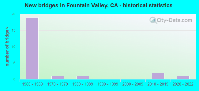
- New bridges - historical statistics
- 191960-1969
- 11970-1979
- 11980-1989
- 22010-2019
- 12020-2022


- Bridge Condition - Deck
- 88.9%Good
- 11.1%Fair

- Bridge Condition - Superstructure
- 88.9%Good
- 11.1%Fair

- Bridge Condition - Substructure
- 66.7%Good
- 11.1%Satisfactory
- 22.2%Fair

- Bridge Condition - Channel
- 33.3%Excellent
- 66.7%Very good
Find on map >> Show street view
Structure Number: 55 0261, Location: 12-ORA-405-14.13-FNV (Lat: 33.708808, Lng: -117.959100), Route carried "on" structure: City street M029, Year Built: 1966, Status: Open, Structure Length: 9.63m (31.59ft), Average Daily Traffic: 10,000 (year 2011), Truck Traffic: 3%, Average Future Daily Traffic: 11,797 (year 2038), Design Load: HS 20+Mod, Features Intersected: ROUTE 405, Facility Carried by Structure: SLATER AVE
Minimum Vertical Clearance: 30+ m (98+ ft), Kilometerpoint: 0.000, Lanes on structure: 4, Lanes under structure: 11, Owner: State Highway Agency, Approaching Roadway Width: 15.8m (51.8ft), Skew: 4 degrees, Material/Design: Concrete continuous, Design/Construction: Box Beam or Girders - Multiple, Number Of Spans In Main Unit: 4, Length of Maximum Span: 39.0m (128.0ft), Curb or Sidewalk Widths: Left: 1.5m (4.9ft), Right: 1.5m (4.9ft), Curb-To-Curb Width: 15.8m (51.8ft), Out-to-Out Width: 19.5m (64.0ft)
Condition: Deck: Good, Superstructure: Good, Substructure: Good, Operating Rating: 54.1 metric tons, Method Used To Determine Operating Rating: Assigned rating based on Load Factor Design (LFD) reported in metric tons, Inventory Rating: 32.4 metric tons, Method Used To Determine Inventory Rating: Assigned rating based on Load Factor Design (LFD) reported in metric tons, Structural Evaluation: Better than present minimum criteria, Deck Geometry: Meets minimum limits, Underclear: High priority of corrective action, Approach Roadway Alignment: Equal to present desirable criteria, Designated Inspection Frequency: Every 24 months, Inspection Date: August 2021, Deck Structure Type: Concrete Cast-file-Place, Wearing Surface/Protective System: Wearing Surface: Monolithic Concrete
Find on map >> Show street view
Structure Number: 55 0262, Location: 12-ORA-405-14.50-FNV (Lat: 33.712144, Lng: -117.962997), Route carried "on" structure: City street M075, Year Built: 1966, Status: Open, Structure Length: 9.20m (30.18ft), Average Daily Traffic: 10,000 (year 2011), Truck Traffic: 3%, Average Future Daily Traffic: 11,797 (year 2038), Design Load: HS 20+Mod, Features Intersected: ROUTE 405, Facility Carried by Structure: BUSHARD ST
Minimum Vertical Clearance: 30+ m (98+ ft), Kilometerpoint: 0.000, Lanes on structure: 4, Lanes under structure: 10, Owner: State Highway Agency, Approaching Roadway Width: 15.8m (51.8ft), Skew: 4 degrees, Material/Design: Concrete continuous, Design/Construction: Box Beam or Girders - Multiple, Number Of Spans In Main Unit: 4, Length of Maximum Span: 34.4m (112.9ft), Curb or Sidewalk Widths: Left: 1.5m (4.9ft), Right: 0.6m (2.0ft), Curb-To-Curb Width: 15.8m (51.8ft), Out-to-Out Width: 18.6m (61.0ft)
Condition: Deck: Fair, Superstructure: Fair, Substructure: Fair, Operating Rating: 54.1 metric tons, Method Used To Determine Operating Rating: Assigned rating based on Load Factor Design (LFD) reported in metric tons, Inventory Rating: 32.4 metric tons, Method Used To Determine Inventory Rating: Assigned rating based on Load Factor Design (LFD) reported in metric tons, Structural Evaluation: Somewhat better than minimum adequacy, Deck Geometry: Meets minimum limits, Underclear: High priority of corrective action, Approach Roadway Alignment: Equal to present desirable criteria, Designated Inspection Frequency: Every 24 months, Inspection Date: August 2021, Deck Structure Type: Concrete Cast-file-Place, Wearing Surface/Protective System: Wearing Surface: Monolithic Concrete
Find on map >> Show street view
Structure Number: 55 0402, Location: 12-ORA-405-13.78-FNV (Lat: 33.704542, Lng: -117.954208), Route carried "on" structure: City street M004, Year Built: 1966, Status: Open, Structure Length: 13.62m (44.69ft), Average Daily Traffic: 20,000 (year 2011), Truck Traffic: 3%, Average Future Daily Traffic: 23,592 (year 2038), Design Load: HS 20+Mod, Features Intersected: INTERSTATE 405, Facility Carried by Structure: BROOKHURST ST
Minimum Vertical Clearance: 30+ m (98+ ft), Kilometerpoint: 0.000, Lanes on structure: 8, Lanes under structure: 14, Owner: State Highway Agency, Approaching Roadway Width: 30.5m (100.1ft), Skew: 24 degrees, Material/Design: Concrete continuous, Design/Construction: Box Beam or Girders - Multiple, Number Of Spans In Main Unit: 4, Length of Maximum Span: 35.7m (117.1ft), Curb or Sidewalk Widths: Left: 1.5m (4.9ft), Right: 1.5m (4.9ft), Curb-To-Curb Width: 30.5m (100.1ft), Out-to-Out Width: 36.6m (120.1ft)
Condition: Deck: Good, Superstructure: Good, Substructure: Good, Operating Rating: 54.1 metric tons, Method Used To Determine Operating Rating: Assigned rating based on Load Factor Design (LFD) reported in metric tons, Inventory Rating: 32.4 metric tons, Method Used To Determine Inventory Rating: Assigned rating based on Load Factor Design (LFD) reported in metric tons, Structural Evaluation: Better than present minimum criteria, Deck Geometry: Somewhat better than minimum adequacy, Underclear: High priority of corrective action, Approach Roadway Alignment: Equal to present desirable criteria, Designated Inspection Frequency: Every 24 months, Inspection Date: August 2021, Deck Structure Type: Concrete Cast-file-Place, Wearing Surface/Protective System: Wearing Surface: Monolithic Concrete
Find on map >> Show street view
Structure Number: 55 0421F, Location: 12-ORA-405-8.65-IRVN (Lat: 33.686958, Lng: -117.870911), Route carried "on" structure: Ramp Interstate 405, Year Built: 1968, Status: Open, Structure Length: 13.20m (43.31ft), Average Daily Traffic: 28,500 (year 2011), Truck Traffic: 5%, Average Future Daily Traffic: 33,619 (year 2038), Design Load: HS 20+Mod, Features Intersected: I 405 & N405-S55 CONN
Minimum Vertical Clearance: 30+ m (98+ ft), Kilometerpoint: 8.650, Lanes on structure: 2, Lanes under structure: 12, Owner: State Highway Agency, Approaching Roadway Width: 11.0m (36.1ft), Skew: 9 degrees, Material/Design: Concrete continuous, Design/Construction: Box Beam or Girders - Multiple, Number Of Spans In Main Unit: 5, Length of Maximum Span: 30.5m (100.1ft), Curb or Sidewalk Widths: Left: 0.6m (2.0ft), Right: 0.0m, Curb-To-Curb Width: 11.0m (36.1ft), Out-to-Out Width: 12.2m (40.0ft)
Condition: Deck: Good, Superstructure: Good, Substructure: Good, Operating Rating: 54.1 metric tons, Method Used To Determine Operating Rating: Assigned rating based on Load Factor Design (LFD) reported in metric tons, Inventory Rating: 32.4 metric tons, Method Used To Determine Inventory Rating: Assigned rating based on Load Factor Design (LFD) reported in metric tons, Structural Evaluation: Better than present minimum criteria, Deck Geometry: Better than present minimum criteria, Underclear: High priority of corrective action, Approach Roadway Alignment: Equal to present desirable criteria, Designated Inspection Frequency: Every 24 months, Inspection Date: August 2021, Deck Structure Type: Concrete Cast-file-Place
Find on map >> Show street view
Structure Number: 55 0429, Location: 12-ORA-405-13.15-FNV (Lat: 33.699667, Lng: -117.945603), Route carried "on" structure: City street M076, Year Built: 1966, Status: Open, Structure Length: 7.68m (25.20ft), Average Daily Traffic: 5,000 (year 2021), Truck Traffic: 3%, Average Future Daily Traffic: 5,898 (year 2043), Design Load: HS 20+Mod, Features Intersected: INTERSTATE 405, Facility Carried by Structure: WARD ST
Minimum Vertical Clearance: 30+ m (98+ ft), Kilometerpoint: 0.000, Lanes on structure: 2, Lanes under structure: 12, Owner: State Highway Agency, Approaching Roadway Width: 9.1m (29.9ft), Skew: 22 degrees, Material/Design: Concrete continuous, Design/Construction: Box Beam or Girders - Multiple, Number Of Spans In Main Unit: 4, Length of Maximum Span: 27.1m (88.9ft), Curb or Sidewalk Widths: Left: 1.5m (4.9ft), Right: 0.0m, Curb-To-Curb Width: 9.1m (29.9ft), Out-to-Out Width: 11.3m (37.1ft)
Condition: Deck: Good, Superstructure: Good, Substructure: Fair, Operating Rating: 54.1 metric tons, Method Used To Determine Operating Rating: Assigned rating based on Load Factor Design (LFD) reported in metric tons, Inventory Rating: 32.4 metric tons, Method Used To Determine Inventory Rating: Assigned rating based on Load Factor Design (LFD) reported in metric tons, Structural Evaluation: Somewhat better than minimum adequacy, Deck Geometry: Meets minimum limits, Underclear: High priority of corrective action, Approach Roadway Alignment: Equal to present desirable criteria, Designated Inspection Frequency: Every 24 months, Inspection Date: August 2021, Deck Structure Type: Concrete Cast-file-Place, Wearing Surface/Protective System: Wearing Surface: Monolithic Concrete
Find on map >> Show street view
Structure Number: 55 0477, Location: 12-ORA-405-12.90-FNV (Lat: 33.698553, Lng: -117.941517), Route carried "on" structure: Interstate 405, Year Built: 1966, Status: Open, Structure Length: 0.67m (2.20ft), Average Daily Traffic: 302,000 (year 2011), Truck Traffic: 6%, Average Future Daily Traffic: 432,000 (year 2038), Features Intersected: EAST VALLEY CHANNEL
Minimum Vertical Clearance: 30+ m (98+ ft), Kilometerpoint: 12.900, Lanes on structure: 13, Base Highway Network: Yes (Inventory Route: 4, Subroute: 1), Owner: State Highway Agency, Approaching Roadway Width: 51.5m (169.0ft), Skew: 30 degrees, Material/Design: Concrete, Design/Construction: Culvert, Number Of Spans In Main Unit: 2, Length of Maximum Span: 3.0m (9.8ft), Curb-To-Curb Width: 51.5m (169.0ft), Out-to-Out Width: 52.5m (172.2ft)
Condition: Channel: Very good, Culverts: Good, Operating Rating: 54.1 metric tons, Method Used To Determine Operating Rating: Field evaluation and documented engineering judgment, Inventory Rating: 32.4 metric tons, Method Used To Determine Inventory Rating: Field evaluation and documented engineering judgment, Structural Evaluation: Better than present minimum criteria, Deck Geometry: Meets minimum limits, Waterway Adequacy: Equal to present desirable criteria, Approach Roadway Alignment: Equal to present desirable criteria, Designated Inspection Frequency: Every 24 months, Inspection Date: August 2021
Find on map >> Show street view
Structure Number: 55 0478, Location: 12-ORA-405-15.00-FNV (Lat: 33.717586, Lng: -117.968708), Route carried "on" structure: Interstate 405, Year Built: 1966, Status: Open, Structure Length: 1.25m (4.10ft), Average Daily Traffic: 263,000 (year 2011), Truck Traffic: 7%, Average Future Daily Traffic: 362,000 (year 2038), Design Load: HS 20+Mod, Features Intersected: OCEAN VIEW CHANNEL
Minimum Vertical Clearance: 30+ m (98+ ft), Kilometerpoint: 15.000, Lanes on structure: 13, Base Highway Network: Yes (Inventory Route: 4, Subroute: 1), Owner: State Highway Agency, Approaching Roadway Width: 64.0m (210.0ft), Skew: 35 degrees, Material/Design: Concrete, Design/Construction: Culvert, Number Of Spans In Main Unit: 2, Length of Maximum Span: 6.2m (20.3ft), Curb-To-Curb Width: 64.0m (210.0ft), Out-to-Out Width: 65.0m (213.3ft)
Condition: Channel: Very good, Culverts: Good, Operating Rating: 54.1 metric tons, Method Used To Determine Operating Rating: Field evaluation and documented engineering judgment, Inventory Rating: 32.4 metric tons, Method Used To Determine Inventory Rating: Field evaluation and documented engineering judgment, Structural Evaluation: Better than present minimum criteria, Deck Geometry: Superior to present desirable criteria, Waterway Adequacy: Equal to present desirable criteria, Approach Roadway Alignment: Equal to present desirable criteria, Designated Inspection Frequency: Every 24 months, Inspection Date: August 2021
Find on map >> Show street view
Structure Number: 55 1121, Location: 12-ORA-405-15.21-HNTB (Lat: 33.719250, Lng: -117.971722), Route carried "on" structure: City street , Year Built: 2021, Status: Open, Structure Length: 13.54m (44.42ft), Average Daily Traffic: 254,000 (year 2021), Truck Traffic: 7%, Average Future Daily Traffic: 320,000 (year 2040), Design Load: HL 93, Features Intersected: ROUTE 405, Facility Carried by Structure: MAGNOLIA STREET
Minimum Vertical Clearance: 30+ m (98+ ft), Kilometerpoint: 0.000, Lanes on structure: 6, Lanes under structure: 11, Base Highway Network: Yes, Owner: State Highway Agency, Approaching Roadway Width: 31.0m (101.7ft), Skew: 4 degrees, Material/Design: Concrete continuous, Design/Construction: Box Beam or Girders - Multiple, Number Of Spans In Main Unit: 2, Length of Maximum Span: 71.8m (235.6ft), Curb or Sidewalk Widths: Left: 2.0m (6.6ft), Right: 2.0m (6.6ft), Curb-To-Curb Width: 28.0m (91.9ft), Out-to-Out Width: 35.2m (115.5ft)
Condition: Deck: Good, Superstructure: Good, Substructure: Good, Operating Rating: 42.1 metric tons, Method Used To Determine Operating Rating: Assigned ratings based on Load and Resistance Factor Design (LRFD) reported by rating factor (RF) using HL93 loadings, Inventory Rating: 32.4 metric tons, Method Used To Determine Inventory Rating: Assigned ratings based on Load and Resistance Factor Design (LRFD) reported by rating factor (RF) using HL93 loadings, Structural Evaluation: Better than present minimum criteria, Deck Geometry: Superior to present desirable criteria, Underclear: Equal to present minimum criteria, Approach Roadway Alignment: Equal to present desirable criteria, Designated Inspection Frequency: Every 24 months, Inspection Date: July 2021, Deck Structure Type: Concrete Cast-file-Place
Find on map >> Show street view
Structure Number: 55 1122, Location: 12-ORA-405-14.13-FNV (Lat: 33.708833, Lng: -117.959056), Route carried "on" structure: City street M029, Year Built: 2019, Status: Open, Structure Length: 10.05m (32.97ft), Average Daily Traffic: 20,000 (year 2016), Truck Traffic: 3%, Average Future Daily Traffic: 11,797 (year 2038), Design Load: HS 20, Features Intersected: ROUTE 405, Facility Carried by Structure: SLATER AVENUE
Minimum Vertical Clearance: 30+ m (98+ ft), Kilometerpoint: 0.000, Lanes on structure: 4, Lanes under structure: 11, Owner: State Highway Agency, Approaching Roadway Width: 17.7m (58.1ft), Skew: 4 degrees, Material/Design: Concrete continuous, Design/Construction: Box Beam or Girders - Multiple, Number Of Spans In Main Unit: 2, Length of Maximum Span: 53.1m (174.2ft), Curb or Sidewalk Widths: Left: 1.8m (5.9ft), Right: 1.8m (5.9ft), Curb-To-Curb Width: 17.7m (58.1ft), Out-to-Out Width: 21.9m (71.9ft)
Condition: Deck: Good, Superstructure: Good, Substructure: Good, Operating Rating: 54.0 metric tons, Method Used To Determine Operating Rating: Field evaluation and documented engineering judgment, Inventory Rating: 32.4 metric tons, Method Used To Determine Inventory Rating: Field evaluation and documented engineering judgment, Structural Evaluation: Better than present minimum criteria, Deck Geometry: Somewhat better than minimum adequacy, Underclear: Superior to present desirable criteria, Approach Roadway Alignment: Better than present minimum criteria, Designated Inspection Frequency: Every 24 months, Inspection Date: August 2021, Deck Structure Type: Concrete Cast-file-Place
Find on map >> Show street view
Structure Number: 55C0095, Location: 0.3 MI. S/O ELLIS AVENUE (Lat: 33.690469, Lng: -117.953950), Route carried "on" structure: City street , Year Built: 1966, Status: Open, Structure Length: 0.91m (2.99ft), Average Daily Traffic: 47,000 (year 2021), Truck Traffic: 1%, Average Future Daily Traffic: 97,829 (year 2040), Features Intersected: FOUNTAIN VALLEY CHANNEL, Facility Carried by Structure: BROOKHURST STREET
Minimum Vertical Clearance: 30+ m (98+ ft), Kilometerpoint: 0.000, Lanes on structure: 6, Base Highway Network: Yes, Owner: City or Municipal Highway Agency, Approaching Roadway Width: 26.2m (86.0ft), Skew: 30 degrees, Material/Design: Concrete, Design/Construction: Culvert, Number Of Spans In Main Unit: 3, Length of Maximum Span: 2.7m (8.9ft), Curb or Sidewalk Widths: Left: 2.4m (7.9ft), Right: 2.4m (7.9ft), Curb-To-Curb Width: 26.2m (86.0ft), Out-to-Out Width: 36.6m (120.1ft)
Condition: Channel: Very good, Culverts: Good, Operating Rating: 40.5 metric tons, Method Used To Determine Operating Rating: Field evaluation and documented engineering judgment, Inventory Rating: 24.3 metric tons, Method Used To Determine Inventory Rating: Field evaluation and documented engineering judgment, Structural Evaluation: Equal to present minimum criteria, Deck Geometry: Equal to present minimum criteria, Waterway Adequacy: Superior to present desirable criteria, Approach Roadway Alignment: Equal to present desirable criteria, Designated Inspection Frequency: Every 24 months, Inspection Date: March 2021, Deck Structure Type: Concrete Cast-file-Place, Wearing Surface/Protective System: Wearing Surface: Bituminous
Find on map >> Show street view
Structure Number: 55C0097, Location: 0.6 MI W/O HARBOR BLVD. (Lat: 33.701811, Lng: -117.930811), Route carried "on" structure: County highway , Year Built: 1983, Status: Open, Structure Length: 11.00m (36.09ft), Average Daily Traffic: 26,000 (year 2018), Truck Traffic: 1%, Average Future Daily Traffic: 54,119 (year 2039), Design Load: HS 20, Features Intersected: SANTA ANA RIVER CHANNEL, Facility Carried by Structure: TALBERT/MACARTHUR
Minimum Vertical Clearance: 30+ m (98+ ft), Kilometerpoint: 0.000, Lanes on structure: 4, Base Highway Network: Yes, Owner: County Highway Agency, Approaching Roadway Width: 20.7m (67.9ft), Skew: 3 degrees, Material/Design: Concrete continuous, Design/Construction: Box Beam or Girders - Multiple, Number Of Spans In Main Unit: 4, Length of Maximum Span: 29.9m (98.1ft), Curb or Sidewalk Widths: Left: 1.5m (4.9ft), Right: 1.5m (4.9ft), Curb-To-Curb Width: 20.7m (67.9ft), Out-to-Out Width: 24.4m (80.1ft)
Condition: Deck: Good, Superstructure: Good, Substructure: Good, Channel: Excellent, Operating Rating: 54.1 metric tons, Method Used To Determine Operating Rating: Assigned rating based on Load Factor Design (LFD) reported in metric tons, Inventory Rating: 32.4 metric tons, Method Used To Determine Inventory Rating: Assigned rating based on Load Factor Design (LFD) reported in metric tons, Structural Evaluation: Better than present minimum criteria, Deck Geometry: Superior to present desirable criteria, Waterway Adequacy: Superior to present desirable criteria, Approach Roadway Alignment: Equal to present desirable criteria, Designated Inspection Frequency: Every 48 months, Inspection Date: January 2020, Deck Structure Type: Concrete Cast-file-Place
Find on map >> Show street view
Structure Number: 55C037, Location: 0.3 MI W/O BRISTOL ST (Lat: 33.707322, Lng: -117.891069), Route carried "on" structure: City street , Year Built: 1965, Status: Open, Structure Length: 0.67m (2.20ft), Average Daily Traffic: 22,000 (year 2021), Truck Traffic: 1%, Average Future Daily Traffic: 49,330 (year 2041), Features Intersected: SANTA ANA GARDENS CHA, Facility Carried by Structure: SEGERSTROM AVE
Minimum Vertical Clearance: 30+ m (98+ ft), Kilometerpoint: 0.000, Lanes on structure: 4, Base Highway Network: Yes, Owner: City or Municipal Highway Agency, Approaching Roadway Width: 15.2m (49.9ft), Skew: 30 degrees, Material/Design: Concrete, Design/Construction: Culvert, Number Of Spans In Main Unit: 2, Length of Maximum Span: 3.0m (9.8ft), Curb or Sidewalk Widths: Left: 3.0m (9.8ft), Right: 2.7m (8.9ft), Curb-To-Curb Width: 15.2m (49.9ft), Out-to-Out Width: 25.8m (84.6ft)
Condition: Channel: Very good, Culverts: Good, Operating Rating: 40.5 metric tons, Method Used To Determine Operating Rating: Field evaluation and documented engineering judgment, Inventory Rating: 24.3 metric tons, Method Used To Determine Inventory Rating: Field evaluation and documented engineering judgment, Structural Evaluation: Equal to present minimum criteria, Deck Geometry: High priority of corrective action, Waterway Adequacy: Equal to present desirable criteria, Approach Roadway Alignment: Equal to present desirable criteria, Designated Inspection Frequency: Every 24 months, Inspection Date: Febuary 2021
Find on map >> Show street view
Structure Number: 55C0371, Location: 0.3 MI. W/O HARBOR BLVD. (Lat: 33.708975, Lng: -117.926083), Route carried "on" structure: County highway , Year Built: 1974, Year Reconstructed: 1982, Status: Open, Structure Length: 10.00m (32.81ft), Average Daily Traffic: 30,000 (year 2019), Truck Traffic: 1%, Average Future Daily Traffic: 48,034 (year 2038), Design Load: HS 20, Features Intersected: SANTA ANA RIVER CHANNEL, Facility Carried by Structure: SEGERSTROM-SLATER
Minimum Vertical Clearance: 30+ m (98+ ft), Kilometerpoint: 0.000, Lanes on structure: 4, Owner: County Highway Agency, Approaching Roadway Width: 20.1m (65.9ft), Skew: 1 degrees, Material/Design: Concrete continuous, Design/Construction: Tee Beam, Number Of Spans In Main Unit: 5, Length of Maximum Span: 21.9m (71.9ft), Curb or Sidewalk Widths: Left: 1.5m (4.9ft), Right: 1.5m (4.9ft), Curb-To-Curb Width: 19.5m (64.0ft), Out-to-Out Width: 23.2m (76.1ft)
Condition: Deck: Good, Superstructure: Good, Substructure: Satisfactory, Channel: Excellent, Operating Rating: 46.3 metric tons, Method Used To Determine Operating Rating: Load and Resistance Factor Rating (LRFR) rating reported by rating factor(RF) method using HL-93 loadings, Inventory Rating: 36.0 metric tons, Method Used To Determine Inventory Rating: Load and Resistance Factor Rating (LRFR) rating reported by rating factor(RF) method using HL-93 loadings, Structural Evaluation: Equal to present minimum criteria, Deck Geometry: Better than present minimum criteria, Waterway Adequacy: Superior to present desirable criteria, Approach Roadway Alignment: Equal to present desirable criteria, Designated Inspection Frequency: Every 48 months, Inspection Date: June 2021, Deck Structure Type: Concrete Cast-file-Place
Find on map >> Show street view
Structure Number: 55C0379, Location: 0.25 MI. W/O BUSHARD ST. (Lat: 33.693950, Lng: -117.967239), Route carried "on" structure: City street , Year Built: 1969, Status: Open, Structure Length: 0.79m (2.59ft), Average Daily Traffic: 22,000 (year 2021), Truck Traffic: 1%, Average Future Daily Traffic: 45,792 (year 2040), Design Load: HS 20, Features Intersected: TALBERT CHANNEL, Facility Carried by Structure: ELLIS AVENUE
Minimum Vertical Clearance: 30+ m (98+ ft), Kilometerpoint: 0.000, Lanes on structure: 4, Owner: City or Municipal Highway Agency, Approaching Roadway Width: 19.5m (64.0ft), Material/Design: Concrete, Design/Construction: Culvert, Number Of Spans In Main Unit: 3, Length of Maximum Span: 2.4m (7.9ft), Curb or Sidewalk Widths: Left: 2.4m (7.9ft), Right: 2.5m (8.2ft), Curb-To-Curb Width: 19.5m (64.0ft), Out-to-Out Width: 25.0m (82.0ft)
Condition: Channel: Excellent, Culverts: Good, Operating Rating: 40.5 metric tons, Method Used To Determine Operating Rating: Field evaluation and documented engineering judgment, Inventory Rating: 24.3 metric tons, Method Used To Determine Inventory Rating: Field evaluation and documented engineering judgment, Structural Evaluation: Equal to present minimum criteria, Deck Geometry: Better than present minimum criteria, Waterway Adequacy: Superior to present desirable criteria, Approach Roadway Alignment: Equal to present desirable criteria, Designated Inspection Frequency: Every 24 months, Inspection Date: March 2021, Deck Structure Type: Concrete Cast-file-Place
Find on map >> Show street view
Structure Number: 55C0381, Location: 0.1 MI. E/O BROOKHURST ST (Lat: 33.694047, Lng: -117.952092), Route carried "on" structure: City street , Year Built: 1966, Status: Open, Structure Length: 0.88m (2.89ft), Average Daily Traffic: 22,000 (year 2021), Truck Traffic: 1%, Average Future Daily Traffic: 45,792 (year 2040), Features Intersected: FOUNTAIN VALLEY CHANNEL, Facility Carried by Structure: ELLIS AVENUE
Minimum Vertical Clearance: 30+ m (98+ ft), Kilometerpoint: 0.000, Lanes on structure: 5, Owner: City or Municipal Highway Agency, Approaching Roadway Width: 19.2m (63.0ft), Material/Design: Concrete, Design/Construction: Culvert, Number Of Spans In Main Unit: 3, Length of Maximum Span: 2.7m (8.9ft), Curb or Sidewalk Widths: Left: 2.6m (8.5ft), Right: 2.4m (7.9ft), Curb-To-Curb Width: 19.2m (63.0ft), Out-to-Out Width: 25.0m (82.0ft)
Condition: Channel: Very good, Culverts: Good, Operating Rating: 40.5 metric tons, Method Used To Determine Operating Rating: Field evaluation and documented engineering judgment, Inventory Rating: 24.3 metric tons, Method Used To Determine Inventory Rating: Field evaluation and documented engineering judgment, Structural Evaluation: Equal to present minimum criteria, Deck Geometry: Meets minimum limits, Waterway Adequacy: Superior to present desirable criteria, Approach Roadway Alignment: Equal to present desirable criteria, Designated Inspection Frequency: Every 24 months, Inspection Date: March 2021, Deck Structure Type: Concrete Cast-file-Place, Wearing Surface/Protective System: Wearing Surface: Bituminous
Find on map >> Show street view
Structure Number: 55C0466, Location: 0.1 MI. N/O WARNER AVENUE (Lat: 33.717792, Lng: -117.963083), Route carried "on" structure: City street , Year Built: 1961, Status: Open, Structure Length: 0.67m (2.20ft), Average Daily Traffic: 14,000 (year 2021), Truck Traffic: 1%, Average Future Daily Traffic: 44,003 (year 2040), Design Load: HS 20, Features Intersected: OCEAN VIEW CHANNEL, Facility Carried by Structure: BUSHARD STREET
Minimum Vertical Clearance: 30+ m (98+ ft), Kilometerpoint: 0.000, Lanes on structure: 4, Owner: City or Municipal Highway Agency, Approaching Roadway Width: 19.3m (63.3ft), Material/Design: Concrete, Design/Construction: Culvert, Number Of Spans In Main Unit: 2, Length of Maximum Span: 3.0m (9.8ft), Curb or Sidewalk Widths: Left: 2.4m (7.9ft), Right: 2.6m (8.5ft), Curb-To-Curb Width: 19.3m (63.3ft), Out-to-Out Width: 24.7m (81.0ft)
Condition: Channel: Very good, Culverts: Good, Operating Rating: 40.5 metric tons, Method Used To Determine Operating Rating: Field evaluation and documented engineering judgment, Inventory Rating: 24.3 metric tons, Method Used To Determine Inventory Rating: Field evaluation and documented engineering judgment, Structural Evaluation: Equal to present minimum criteria, Deck Geometry: Equal to present minimum criteria, Waterway Adequacy: Superior to present desirable criteria, Approach Roadway Alignment: Equal to present desirable criteria, Designated Inspection Frequency: Every 24 months, Inspection Date: March 2021, Deck Structure Type: Concrete Cast-file-Place, Wearing Surface/Protective System: Wearing Surface: Bituminous
Find on map >> Show street view
Structure Number: 55 026, Location: 12-ORA-405-13.41-FNV (Lat: 33.701658, Lng: -117.950033), Route carried "under" structure: Interstate 405, Year Built: 1966, Structure Length: 0. m, Average Daily Traffic: 262,000 (year 2020), Truck Traffic: 4%, Features Intersected: ROUTE 405, Facility Carried by Structure: TALBERT AVE
Minimum Vertical Clearance: 5.79m (19.00ft), Kilometerpoint: 13.410, Lanes on structure: 4, Lanes under structure: 12, Material/Design: Concrete continuous, Design/Construction: Box Beam or Girders - Multiple, Length of Maximum Span: 45.1m (148.0ft)
Find on map >> Show street view
Structure Number: 55 0261, Location: 12-ORA-405-14.13-FNV (Lat: 33.708808, Lng: -117.959100), Route carried "under" structure: Interstate 405, Year Built: 1966, Structure Length: 0. m, Average Daily Traffic: 263,000 (year 2011), Truck Traffic: 7%, Features Intersected: ROUTE 405, Facility Carried by Structure: SLATER AVE
Minimum Vertical Clearance: 5.33m (17.49ft), Kilometerpoint: 14.130, Lanes on structure: 4, Lanes under structure: 11, Material/Design: Concrete continuous, Design/Construction: Box Beam or Girders - Multiple, Length of Maximum Span: 39.0m (128.0ft)
Find on map >> Show street view
Structure Number: 55 0262, Location: 12-ORA-405-14.50-FNV (Lat: 33.712144, Lng: -117.962997), Route carried "under" structure: Interstate 405, Year Built: 1966, Structure Length: 0. m, Average Daily Traffic: 263,000 (year 2011), Truck Traffic: 7%, Features Intersected: ROUTE 405, Facility Carried by Structure: BUSHARD ST
Minimum Vertical Clearance: 5.20m (17.06ft), Kilometerpoint: 14.500, Lanes on structure: 4, Lanes under structure: 10, Material/Design: Concrete continuous, Design/Construction: Box Beam or Girders - Multiple, Length of Maximum Span: 34.4m (112.9ft)
Find on map >> Show street view
Structure Number: 55 0402, Location: 12-ORA-405-13.78-FNV (Lat: 33.704542, Lng: -117.954208), Route carried "under" structure: Interstate 405, Year Built: 1966, Structure Length: 0. m, Average Daily Traffic: 263,000 (year 2011), Truck Traffic: 7%, Features Intersected: INTERSTATE 405, Facility Carried by Structure: BROOKHURST ST
Minimum Vertical Clearance: 5.23m (17.16ft), Kilometerpoint: 13.780, Lanes on structure: 8, Lanes under structure: 10, Material/Design: Concrete continuous, Design/Construction: Box Beam or Girders - Multiple, Length of Maximum Span: 35.7m (117.1ft)
Find on map >> Show street view
Structure Number: 55 0402, Location: 12-ORA-405-13.78-FNV (Lat: 33.704542, Lng: -117.954208), Route carried "under" structure: Ramp Interstate 405, Year Built: 1966, Structure Length: 0. m, Average Daily Traffic: 9,300 (year 2011), Truck Traffic: 3%, Features Intersected: INTERSTATE 405, Facility Carried by Structure: BROOKHURST ST
Minimum Vertical Clearance: 5.05m (16.57ft), Kilometerpoint: 13.780, Lanes on structure: 8, Lanes under structure: 2, Material/Design: Concrete continuous, Design/Construction: Box Beam or Girders - Multiple, Length of Maximum Span: 35.7m (117.1ft)
Find on map >> Show street view
Structure Number: 55 0402, Location: 12-ORA-405-13.78-FNV (Lat: 33.704542, Lng: -117.954208), Route carried "under" structure: Ramp Interstate 405, Year Built: 1966, Structure Length: 0. m, Average Daily Traffic: 8,500 (year 2011), Truck Traffic: 3%, Features Intersected: INTERSTATE 405, Facility Carried by Structure: BROOKHURST ST
Minimum Vertical Clearance: 5.25m (17.22ft), Kilometerpoint: 13.780, Lanes on structure: 8, Lanes under structure: 2, Material/Design: Concrete continuous, Design/Construction: Box Beam or Girders - Multiple, Length of Maximum Span: 35.7m (117.1ft)
Find on map >> Show street view
Structure Number: 55 0429, Location: 12-ORA-405-13.15-FNV (Lat: 33.699667, Lng: -117.945603), Route carried "under" structure: Interstate 405, Year Built: 1966, Structure Length: 0. m, Average Daily Traffic: 260,000 (year 2020), Truck Traffic: 4%, Features Intersected: INTERSTATE 405, Facility Carried by Structure: WARD ST
Minimum Vertical Clearance: 5.25m (17.22ft), Kilometerpoint: 13.150, Lanes on structure: 2, Lanes under structure: 12, Material/Design: Concrete continuous, Design/Construction: Box Beam or Girders - Multiple, Length of Maximum Span: 27.1m (88.9ft)
Find on map >> Show street view
Structure Number: 55 1122, Location: 12-ORA-405-14.13-FNV (Lat: 33.708833, Lng: -117.959056), Route carried "under" structure: Interstate 405, Year Built: 2019, Structure Length: 0. m, Average Daily Traffic: 280,000 (year 2019), Truck Traffic: 7%, Features Intersected: ROUTE 405, Facility Carried by Structure: SLATER AVENUE
Minimum Vertical Clearance: 6.20m (20.34ft), Kilometerpoint: 14.130, Lanes on structure: 4, Lanes under structure: 11, Material/Design: Concrete continuous, Design/Construction: Box Beam or Girders - Multiple, Length of Maximum Span: 53.1m (174.2ft)