Bridge Statistics for Fort Washington, Maryland (MD)
Condition, Traffic, Stress, Structural Evaluation, Project Costs
- National Bridge Inventory (NBI) Statistics
- 18Number of bridges
- 121ft / 36.9mTotal length
- $499,000Total costs
- 588,254Total average daily traffic
- 41,586Total average daily truck traffic
- National Bridge Inventory (NBI) Registered Bridges for Fort Washington
- No street view available for this location
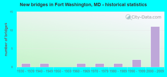
- New bridges - historical statistics
- 11930-1939
- 11940-1949
- 11960-1969
- 11970-1979
- 11980-1989
- 21990-1999
- 112000-2009


- Bridge Condition - Deck
- 57.1%Good
- 42.9%Fair

- Bridge Condition - Superstructure
- 42.9%Good
- 14.3%Satisfactory
- 28.6%Fair
- 14.3%Poor

- Bridge Condition - Substructure
- 42.9%Good
- 28.6%Satisfactory
- 28.6%Fair

- Bridge Condition - Channel
- 80.0%Satisfactory
- 20.0%Fair
Find on map >> Show street view
Structure Number: 10000016017101, Location: 0.985 MILE WEST OF MD 210 (Lat: 38.795731, Lng: -77.014094), Route carried "on" structure: Interstate 95, Year Built: 2007, Status: Open, Structure Length: 4.75m (15.58ft), Average Daily Traffic: 146,744 (year 2020), Truck Traffic: 8%, Average Future Daily Traffic: 158,538 (year 2042), Design Load: HS 25 or greater, Features Intersected: IS 95/IS 495 RAMPS B & T
Minimum Vertical Clearance: 30+ m (98+ ft), Kilometerpoint: 2.816, Lanes on structure: 3, Lanes under structure: 2, Base Highway Network: Yes, Owner: State Highway Agency, Approaching Roadway Width: 17.1m (56.1ft), Material/Design: Prestressed concrete continuous, Design/Construction: Stringer/Multi-beam, Number Of Spans In Main Unit: 2, Length of Maximum Span: 25.3m (83.0ft), Curb-To-Curb Width: 19.0m (62.3ft), Out-to-Out Width: 20.4m (66.9ft)
Condition: Deck: Good, Superstructure: Good, Substructure: Good, Operating Rating: 68.5 metric tons, Method Used To Determine Operating Rating: Load Factor (LF), Inventory Rating: 18.6 metric tons, Method Used To Determine Inventory Rating: Load Factor (LF), Structural Evaluation: Meets minimum limits, Deck Geometry: Superior to present desirable criteria, Underclear: Meets minimum limits, Approach Roadway Alignment: Equal to present desirable criteria, Designated Inspection Frequency: Every 24 months, Inspection Date: November 2020, Deck Structure Type: Concrete Cast-file-Place, Wearing Surface/Protective System: Wearing Surface: Monolithic Concrete, Deck Protection: Epoxy Coated Reinforcing
Find on map >> Show street view
Structure Number: 10000016017201, Location: 0.72 MI S OF WASH DC (Lat: 38.795228, Lng: -77.016847), Route carried "on" structure: Ramp Interstate 95, Year Built: 2005, Status: Open, Structure Length: 14.78m (48.49ft), Average Daily Traffic: 8,837 (year 2021), Truck Traffic: 8%, Average Future Daily Traffic: 11,834 (year 2042), Design Load: HS 25 or greater, Features Intersected: IS 95/495 & RAMP A(8)
Minimum Vertical Clearance: 5.49m (18.01ft), Kilometerpoint: 0.401, Lanes on structure: 2, Lanes under structure: 13, Base Highway Network: Yes, Owner: State Highway Agency, Approaching Roadway Width: 14.0m (45.9ft), Skew: 1 degrees, Material/Design: Steel continuous, Design/Construction: Stringer/Multi-beam, Number Of Spans In Main Unit: 5, Length of Maximum Span: 32.0m (105.0ft), Curb-To-Curb Width: 14.0m (45.9ft), Out-to-Out Width: 14.9m (48.9ft)
Condition: Deck: Good, Superstructure: Good, Substructure: Good, Inventory Rating: 59.9 metric tons, Method Used To Determine Inventory Rating: Load Factor (LF), Structural Evaluation: Better than present minimum criteria, Deck Geometry: Superior to present desirable criteria, Underclear: Equal to present minimum criteria, Approach Roadway Alignment: Equal to present desirable criteria, Designated Inspection Frequency: Every 24 months, Inspection Date: July 2021, Deck Structure Type: Concrete Cast-file-Place, Wearing Surface/Protective System: Wearing Surface: Monolithic Concrete, Deck Protection: Epoxy Coated Reinforcing
Find on map >> Show street view
Structure Number: 100000160219012, Location: 0.18 M N OF BR NO 1622100 (Lat: 38.800297, Lng: -77.002189), Route carried "on" structure: Ramp Interstate 95, Year Built: 2004, Status: Open, Structure Length: 4.24m (13.91ft), Average Daily Traffic: 13,360 (year 2020), Truck Traffic: 8%, Average Future Daily Traffic: 15,627 (year 2042), Design Load: HS 25 or greater, Features Intersected: MD 414 (OXON HILL ROAD)
Minimum Vertical Clearance: 30+ m (98+ ft), Kilometerpoint: 0.869, Lanes on structure: 3, Lanes under structure: 2, Base Highway Network: Yes, Owner: State Highway Agency, Approaching Roadway Width: 21.3m (69.9ft), Skew: 3 degrees, Material/Design: Steel, Design/Construction: Stringer/Multi-beam, Number Of Spans In Main Unit: 1, Length of Maximum Span: 41.1m (134.8ft), Curb-To-Curb Width: 21.3m (69.9ft), Out-to-Out Width: 22.6m (74.1ft)
Condition: Deck: Good, Superstructure: Good, Substructure: Good, Operating Rating: 87.5 metric tons, Method Used To Determine Operating Rating: Load Factor (LF), Inventory Rating: 54.4 metric tons, Method Used To Determine Inventory Rating: Load Factor (LF), Structural Evaluation: Better than present minimum criteria, Deck Geometry: Superior to present desirable criteria, Underclear: High priority of corrective action, Approach Roadway Alignment: Equal to present desirable criteria, Designated Inspection Frequency: Every 24 months, Inspection Date: September 2020, Deck Structure Type: Concrete Cast-file-Place, Wearing Surface/Protective System: Wearing Surface: Monolithic Concrete, Deck Protection: Epoxy Coated Reinforcing
Find on map >> Show street view
Structure Number: 10000016023701, Location: 0.34 M S OF BR NO 1621900 (Lat: 38.798503, Lng: -77.006281), Route carried "on" structure: Interstate 95, Year Built: 1990, Status: Open, Structure Length: 3.51m (11.52ft), Average Daily Traffic: 37,600 (year 2002), Truck Traffic: 8%, Average Future Daily Traffic: 46,951 (year 2022), Design Load: HS 20+Mod, Features Intersected: IS 95/ IS 495 RAMP 'O'
Minimum Vertical Clearance: 30+ m (98+ ft), Kilometerpoint: 0.862, Lanes on structure: 6, Lanes under structure: 1, Owner: State Highway Agency, Approaching Roadway Width: 37.2m (122.0ft), Skew: 20 degrees, Material/Design: Steel, Design/Construction: Stringer/Multi-beam, Number Of Spans In Main Unit: 1, Length of Maximum Span: 31.7m (104.0ft), Curb-To-Curb Width: 37.2m (122.0ft), Out-to-Out Width: 38.4m (126.0ft)
Condition: Deck: Good, Superstructure: Satisfactory, Substructure: Satisfactory, Inventory Rating: 64.4 metric tons, Method Used To Determine Inventory Rating: Load Factor (LF), Structural Evaluation: Equal to present minimum criteria, Deck Geometry: Superior to present desirable criteria, Underclear: Superior to present desirable criteria, Approach Roadway Alignment: Equal to present desirable criteria, Designated Inspection Frequency: Every 24 months, Inspection Date: January 2020, Deck Structure Type: Concrete Cast-file-Place, Wearing Surface/Protective System: Wearing Surface: Monolithic Concrete, Deck Protection: Epoxy Coated Reinforcing
Find on map >> Show street view
Structure Number: 200000P-031001, Location: 0.30 M N OF LIVINGSTON RD (Lat: 38.759456, Lng: -77.002039), Route carried "on" structure: County highway 114, Year Built: 1963, Status: Posted for load, Structure Length: 3.93m (12.89ft), Average Daily Traffic: 16,526 (year 2016), Truck Traffic: 5%, Average Future Daily Traffic: 24,560 (year 2036), Design Load: H 20, Features Intersected: BROAD CREEK, Facility Carried by Structure: OXON HILL ROAD
Minimum Vertical Clearance: 30+ m (98+ ft), Kilometerpoint: 5.133, Lanes on structure: 2, Owner: County Highway Agency, Approaching Roadway Width: 12.8m (42.0ft), Material/Design: Prestressed concrete, Design/Construction: Box Beam or Girders - Multiple, Number Of Spans In Main Unit: 3, Length of Maximum Span: 12.8m (42.0ft), Curb or Sidewalk Widths: Left: 1.3m (4.3ft), Right: 0.0m, Curb-To-Curb Width: 8.5m (27.9ft), Out-to-Out Width: 11.0m (36.1ft)
Condition: Deck: Fair, Superstructure: Fair, Substructure: Fair, Channel: Fair, Operating Rating: 63.0 metric tons, Method Used To Determine Operating Rating: Load Factor (LF), Inventory Rating: 32.2 metric tons, Method Used To Determine Inventory Rating: Load Factor (LF), Structural Evaluation: Somewhat better than minimum adequacy, Deck Geometry: High priority of replacement, Waterway Adequacy: Somewhat better than minimum adequacy, Approach Roadway Alignment: Equal to present desirable criteria, Length Of Structure Improvement: 3.93m (12.89ft), Designated Inspection Frequency: Every 24 months, Inspection Date: April 2021, Bridge Improvement Cost: $204,000, Roadway Improvement Cost: $20,000, Total Project Cost: $224,000, Wearing Surface/Protective System: Wearing Surface: Bituminous
Find on map >> Show street view
Structure Number: 200000P-039402, Location: 0.10 MI W OF MD 210 (Lat: 38.779222, Lng: -76.998089), Route carried "on" structure: County highway 582, Year Built: 1948, Status: Open, Structure Length: 0.82m (2.69ft), Average Daily Traffic: 6,899 (year 2021), Truck Traffic: 10%, Average Future Daily Traffic: 10,029 (year 2041), Features Intersected: CAREY BRANCH, Facility Carried by Structure: KERBY HILL ROAD
Minimum Vertical Clearance: 30+ m (98+ ft), Kilometerpoint: 0.756, Lanes on structure: 2, Owner: County Highway Agency, Approaching Roadway Width: 12.2m (40.0ft), Skew: 2 degrees, Material/Design: Concrete, Design/Construction: Culvert, Length of Maximum Span: 4.3m (14.1ft), Curb or Sidewalk Widths: Left: 1.5m (4.9ft), Right: 1.5m (4.9ft)
Condition: Channel: Satisfactory, Culverts: Fair, Operating Rating: 77.5 metric tons, Method Used To Determine Operating Rating: Load Factor (LF), Inventory Rating: 46.3 metric tons, Method Used To Determine Inventory Rating: Load Factor (LF), Structural Evaluation: Somewhat better than minimum adequacy, Waterway Adequacy: Better than present minimum criteria, Approach Roadway Alignment: Equal to present minimum criteria, Designated Inspection Frequency: Every 24 months, Inspection Date: January 2021
Find on map >> Show street view
Structure Number: 200000P-048003, Location: 0.42 MI W OF MD 210 (Lat: 38.723825, Lng: -76.997228), Route carried "on" structure: County highway 600, Year Built: 1989, Status: Open, Structure Length: 1.43m (4.69ft), Average Daily Traffic: 13,199 (year 2016), Truck Traffic: 10%, Average Future Daily Traffic: 19,613 (year 2036), Design Load: HS 20, Features Intersected: CLASH CREEK, Facility Carried by Structure: EAST SWAN CREEK RO
Minimum Vertical Clearance: 30+ m (98+ ft), Kilometerpoint: 0.000, Lanes on structure: 2, Owner: County Highway Agency, Approaching Roadway Width: 11.6m (38.1ft), Material/Design: Aluminum, Iron, Design/Construction: Culvert, Number Of Spans In Main Unit: 3, Length of Maximum Span: 4.0m (13.1ft), Curb or Sidewalk Widths: Left: 1.2m (3.9ft), Right: 1.2m (3.9ft), Curb-To-Curb Width: 15.4m (50.5ft), Out-to-Out Width: 20.6m (67.6ft)
Condition: Channel: Satisfactory, Culverts: Fair, Operating Rating: 82.1 metric tons, Method Used To Determine Operating Rating: Load Factor (LF), Inventory Rating: 49.0 metric tons, Method Used To Determine Inventory Rating: Load Factor (LF), Structural Evaluation: Somewhat better than minimum adequacy, Deck Geometry: Superior to present desirable criteria, Waterway Adequacy: High priority of corrective action, Approach Roadway Alignment: Equal to present desirable criteria, Length Of Structure Improvement: 1.43m (4.69ft), Designated Inspection Frequency: Every 24 months, Inspection Date: March 2021
Find on map >> Show street view
Structure Number: 200000P-048301, Location: 0.41 MI S OF MD 210 (Lat: 38.760094, Lng: -76.995253), Route carried "on" structure: County highway 4524, Year Built: 1977, Status: Posted for load, Structure Length: 1.40m (4.59ft), Average Daily Traffic: 5,216 (year 2016), Truck Traffic: 10%, Average Future Daily Traffic: 7,750 (year 2036), Design Load: HS 20, Features Intersected: HUNTERS MILL BRANCH, Facility Carried by Structure: LIVINGSTON ROAD
Minimum Vertical Clearance: 30+ m (98+ ft), Kilometerpoint: 4.248, Lanes on structure: 4, Owner: County Highway Agency, Approaching Roadway Width: 15.9m (52.2ft), Skew: 2 degrees, Material/Design: Prestressed concrete, Design/Construction: Box Beam or Girders - Multiple, Number Of Spans In Main Unit: 1, Length of Maximum Span: 13.4m (44.0ft), Curb or Sidewalk Widths: Left: 1.4m (4.6ft), Right: 1.4m (4.6ft), Curb-To-Curb Width: 15.9m (52.2ft), Out-to-Out Width: 19.2m (63.0ft)
Condition: Deck: Fair, Superstructure: Fair, Substructure: Satisfactory, Channel: Satisfactory, Operating Rating: 59.0 metric tons, Method Used To Determine Operating Rating: Load Factor (LF), Inventory Rating: 36.3 metric tons, Method Used To Determine Inventory Rating: Load Factor (LF), Structural Evaluation: Somewhat better than minimum adequacy, Deck Geometry: Meets minimum limits, Waterway Adequacy: Better than present minimum criteria, Approach Roadway Alignment: Equal to present desirable criteria, Length Of Structure Improvement: 1.40m (4.59ft), Designated Inspection Frequency: Every 24 months, Inspection Date: March 2021, Bridge Improvement Cost: $8,000, Roadway Improvement Cost: $10,000, Total Project Cost: $20,000, Deck Structure Type: Concrete Precast Panels, Wearing Surface/Protective System: Wearing Surface: Bituminous
Find on map >> Show street view
Structure Number: 200000P-048701, Location: 0.49 MI N OF MD 223 (Lat: 38.703444, Lng: -76.974528), Route carried "on" structure: County highway 1202, Year Built: 1932, Year Reconstructed: 1989, Status: Posted for load, Structure Length: 2.01m (6.59ft), Average Daily Traffic: 6,771 (year 2021), Truck Traffic: 10%, Average Future Daily Traffic: 7,481 (year 2041), Features Intersected: PISCATAWAY CREEK, Facility Carried by Structure: LIVINGSTON ROAD
Minimum Vertical Clearance: 30+ m (98+ ft), Kilometerpoint: 4.328, Lanes on structure: 2, Owner: County Highway Agency, Approaching Roadway Width: 9.1m (29.9ft), Material/Design: Concrete, Design/Construction: Tee Beam, Number Of Spans In Main Unit: 2, Length of Maximum Span: 10.1m (33.1ft), Curb-To-Curb Width: 7.3m (24.0ft), Out-to-Out Width: 8.2m (26.9ft)
Condition: Deck: Fair, Superstructure: Poor, Substructure: Fair, Channel: Satisfactory, Operating Rating: 45.4 metric tons, Method Used To Determine Operating Rating: Load Factor (LF), Inventory Rating: 27.2 metric tons, Method Used To Determine Inventory Rating: Load Factor (LF), Structural Evaluation: Meets minimum limits, Deck Geometry: High priority of replacement, Waterway Adequacy: Meets minimum limits, Approach Roadway Alignment: Equal to present desirable criteria, Bridge Posting: Required (Relationship of Operating Rating to Maximum Legal Load: 0.1 - 9.9% below), Length Of Structure Improvement: 2.01m (6.59ft), Designated Inspection Frequency: Every 24 months, Inspection Date: March 2021, Bridge Improvement Cost: $204,000, Roadway Improvement Cost: $51,000, Total Project Cost: $255,000, Deck Structure Type: Concrete Cast-file-Place, Wearing Surface/Protective System: Wearing Surface: Bituminous
Find on map >> Show street view
Structure Number: 10000016017101, Location: 0.985 MILE WEST OF MD 210 (Lat: 38.795731, Lng: -77.014094), Route carried "under" structure: Ramp Interstate 95, Year Built: 2007, Structure Length: 0. m, Features Intersected: IS 95/IS 495 RAMP 'B'
Minimum Vertical Clearance: 5.49m (18.01ft), Kilometerpoint: 1.038, Lanes on structure: 3, Lanes under structure: 1, Material/Design: Prestressed concrete continuous, Design/Construction: Stringer/Multi-beam, Length of Maximum Span: 25.3m (83.0ft)
Find on map >> Show street view
Structure Number: 10000016017101, Location: 0.985 MILE WEST OF MD 210 (Lat: 38.795731, Lng: -77.014094), Route carried "under" structure: Ramp Interstate 95, Year Built: 2007, Structure Length: 0. m, Features Intersected: IS 95/IS 495 RAMP 'T'
Minimum Vertical Clearance: 6.10m (20.01ft), Kilometerpoint: 0.632, Lanes on structure: 3, Lanes under structure: 1, Material/Design: Prestressed concrete continuous, Design/Construction: Stringer/Multi-beam, Length of Maximum Span: 25.3m (83.0ft)
Find on map >> Show street view
Structure Number: 10000016017201, Location: 0.72 MI S OF WASH DC (Lat: 38.795228, Lng: -77.016847), Route carried "under" structure: ServiceInterstate 95, Year Built: 2005, Structure Length: 0. m, Features Intersected: IS 95/IS 495 IL LOCAL
Minimum Vertical Clearance: 6.10m (20.01ft), Kilometerpoint: 2.626, Lanes on structure: 2, Lanes under structure: 3, Material/Design: Steel continuous, Design/Construction: Stringer/Multi-beam, Length of Maximum Span: 32.0m (105.0ft)
Find on map >> Show street view
Structure Number: 10000016017201, Location: 1.61 M FRON VA STATE LINE (Lat: 38.795228, Lng: -77.016847), Route carried "under" structure: Interstate 95, Year Built: 2005, Structure Length: 0. m, Average Daily Traffic: 191,210 (year 2009), Truck Traffic: 11%, Features Intersected: IS 95/IS 495
Minimum Vertical Clearance: 5.79m (19.00ft), Kilometerpoint: 2.590, Lanes on structure: 3, Lanes under structure: 13, Material/Design: Steel continuous, Design/Construction: Stringer/Multi-beam, Length of Maximum Span: 32.0m (105.0ft)
Find on map >> Show street view
Structure Number: 10000016017201, Location: 0.72 MI S OF WASH DC (Lat: 38.795228, Lng: -77.016847), Route carried "under" structure: ServiceInterstate 95, Year Built: 2005, Structure Length: 0. m, Features Intersected: IS 95/IS 495 OL LOCAL
Minimum Vertical Clearance: 6.10m (20.01ft), Kilometerpoint: 2.626, Lanes on structure: 2, Lanes under structure: 2, Material/Design: Steel continuous, Design/Construction: Stringer/Multi-beam, Length of Maximum Span: 32.0m (105.0ft)
Find on map >> Show street view
Structure Number: 10000016017201, Location: 0.72 MI S OF WASH DC (Lat: 38.795228, Lng: -77.016847), Route carried "under" structure: Ramp Interstate 95, Year Built: 2005, Structure Length: 0. m, Features Intersected: IS 95/IS 495 RAMP 'A'
Minimum Vertical Clearance: 5.79m (19.00ft), Kilometerpoint: 2.626, Lanes on structure: 2, Lanes under structure: 1, Material/Design: Steel continuous, Design/Construction: Stringer/Multi-beam, Length of Maximum Span: 32.0m (105.0ft)
Find on map >> Show street view
Structure Number: 10000016021801, Location: 1.683 M N OF VA STATE/L (Lat: 38.795486, Lng: -77.016106), Route carried "under" structure: Ramp Interstate 95, Year Built: 1990, Structure Length: 0. m, Average Daily Traffic: 141,892 (year 2012), Features Intersected: IS 95/IS495 IL LOCAL
Minimum Vertical Clearance: 5.49m (18.01ft), Kilometerpoint: 2.708, Lanes on structure: 2, Lanes under structure: 3, Material/Design: Steel continuous, Design/Construction: Stringer/Multi-beam, Length of Maximum Span: 55.2m (181.1ft)
Find on map >> Show street view
Structure Number: 10000016029101, Location: 0.5 MILE WEST OF MD 210 (Lat: 38.798553, Lng: -77.005503), Route carried "under" structure: Ramp Interstate 295, Year Built: 2008, Structure Length: 0. m, Features Intersected: IS 295 RAMP 'O', Facility Carried by Structure: NAT'L HARBOR N. RD
Minimum Vertical Clearance: 5.49m (18.01ft), Kilometerpoint: 0.203, Lanes on structure: 2, Lanes under structure: 1, Material/Design: Steel, Design/Construction: Stringer/Multi-beam, Length of Maximum Span: 21.3m (69.9ft)
Find on map >> Show street view
Structure Number: 10000016029213, Location: ON ROSALIE ISLAND (Lat: 38.792989, Lng: -77.024256), Route carried "under" structure: Interstate 95, Year Built: 2008, Structure Length: 0. m, Features Intersected: IS 95/IS 495, Facility Carried by Structure: PEDESTRIAN
Minimum Vertical Clearance: 30+ m (98+ ft), Kilometerpoint: 1.944, Lanes under structure: 12, Material/Design: Steel continuous, Design/Construction: Stringer/Multi-beam, Length of Maximum Span: 34.4m (112.9ft)