Bridge Statistics for Flowery Branch, Georgia (GA)
Condition, Traffic, Stress, Structural Evaluation, Project Costs
- National Bridge Inventory (NBI) Statistics
- 18Number of bridges
- 203ft / 62.0mTotal length
- $91,706,000Total costs
- 315,014Total average daily traffic
- 3,165Total average daily truck traffic
- National Bridge Inventory (NBI) Registered Bridges for Flowery Branch
- No street view available for this location
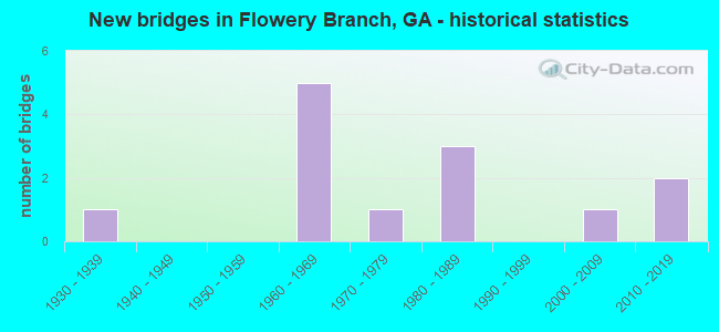
- New bridges - historical statistics
- 11930-1939
- 51960-1969
- 11970-1979
- 31980-1989
- 12000-2009
- 22010-2019


- Bridge Condition - Deck
- 12.5%Excellent
- 62.5%Good
- 25.0%Satisfactory

- Bridge Condition - Superstructure
- 12.5%Excellent
- 25.0%Very good
- 50.0%Good
- 12.5%Satisfactory

- Bridge Condition - Substructure
- 12.5%Excellent
- 75.0%Good
- 12.5%Satisfactory

- Bridge Condition - Channel
- 37.5%Very good
- 25.0%Good
- 37.5%Satisfactory
Find on map >> Show street view
Structure Number: 1390009, Location: 1.4 MI E OF FLOWERY BR (Lat: 34.192358, Lng: -83.902069), Route carried "on" structure: State highway 13, Year Built: 1968, Status: Open, Structure Length: 6.71m (22.01ft), Average Daily Traffic: 13,110 (year 2012), Truck Traffic: 1%, Average Future Daily Traffic: 19,665 (year 2032), Design Load: HS 20+Mod, Features Intersected: SR 419 (I-985 US 23), Facility Carried by Structure: ATLANTA HIGHWAY
Minimum Vertical Clearance: 30+ m (98+ ft), Kilometerpoint: 9.656, Lanes on structure: 2, Lanes under structure: 4, Base Highway Network: Yes, Owner: State Highway Agency, Approaching Roadway Width: 7.3m (24.0ft), Skew: 2 degrees, Material/Design: Steel continuous, Design/Construction: Stringer/Multi-beam, Number Of Spans In Main Unit: 4, Length of Maximum Span: 22.9m (75.1ft), Curb or Sidewalk Widths: Left: 0.2m (0.7ft), Right: 0.2m (0.7ft), Curb-To-Curb Width: 9.1m (29.9ft), Out-to-Out Width: 10.5m (34.4ft)
Condition: Deck: Satisfactory, Superstructure: Good, Substructure: Good, Operating Rating: 51.7 metric tons, Method Used To Determine Operating Rating: Allowable Stress (AS), Inventory Rating: 32.6 metric tons, Method Used To Determine Inventory Rating: Allowable Stress (AS), Structural Evaluation: Better than present minimum criteria, Deck Geometry: Meets minimum limits, Underclear: Meets minimum limits, Approach Roadway Alignment: Better than present minimum criteria, Designated Inspection Frequency: Every 24 months, Inspection Date: May 2021, Bridge Improvement Cost: $860,000, Roadway Improvement Cost: $86,000, Total Project Cost: $1,289,000, Deck Structure Type: Concrete Cast-file-Place
Find on map >> Show street view
Structure Number: 1390043, Location: .7 MI SE OF FLOWERY BR (Lat: 34.178758, Lng: -83.914208), Route carried "on" structure: Interstate 985, Year Built: 1968, Status: Open, Structure Length: 4.08m (13.39ft), Average Daily Traffic: 53,410 (year 2012), Truck Traffic: 1%, Average Future Daily Traffic: 80,115 (year 2032), Design Load: HS 20+Mod, Features Intersected: S-2920 SPOUT SPRINGS RD
Minimum Vertical Clearance: 30+ m (98+ ft), Kilometerpoint: 19.312, Lanes on structure: 2, Lanes under structure: 2, Base Highway Network: Yes, Owner: State Highway Agency, Approaching Roadway Width: 11.6m (38.1ft), Skew: 10 degrees, Material/Design: Steel, Design/Construction: Stringer/Multi-beam, Number Of Spans In Main Unit: 3, Length of Maximum Span: 20.7m (67.9ft), Curb-To-Curb Width: 11.8m (38.7ft), Out-to-Out Width: 12.6m (41.3ft)
Condition: Deck: Good, Superstructure: Good, Substructure: Good, Operating Rating: 46.2 metric tons, Method Used To Determine Operating Rating: Load Factor (LF), Inventory Rating: 27.2 metric tons, Method Used To Determine Inventory Rating: Load Factor (LF), Structural Evaluation: Equal to present minimum criteria, Deck Geometry: Equal to present minimum criteria, Underclear: Meets minimum limits, Approach Roadway Alignment: Equal to present desirable criteria, Designated Inspection Frequency: Every 24 months, Inspection Date: May 2021, Bridge Improvement Cost: $524,000, Roadway Improvement Cost: $52,000, Total Project Cost: $785,000, Deck Structure Type: Concrete Cast-file-Place
Find on map >> Show street view
Structure Number: 1390044, Location: .7 MI SE OF FLOWERY BR (Lat: 34.178897, Lng: -83.914458), Route carried "on" structure: Interstate 985, Year Built: 1968, Status: Open, Structure Length: 4.48m (14.70ft), Average Daily Traffic: 52,640 (year 2012), Truck Traffic: 1%, Average Future Daily Traffic: 78,960 (year 2032), Design Load: HS 20+Mod, Features Intersected: S-2920 SPOUT SPRINGS RD
Minimum Vertical Clearance: 30+ m (98+ ft), Kilometerpoint: 19.312, Lanes on structure: 2, Lanes under structure: 2, Base Highway Network: Yes, Owner: State Highway Agency, Approaching Roadway Width: 11.6m (38.1ft), Skew: 10 degrees, Material/Design: Steel, Design/Construction: Stringer/Multi-beam, Number Of Spans In Main Unit: 3, Length of Maximum Span: 21.0m (68.9ft), Curb-To-Curb Width: 11.9m (39.0ft), Out-to-Out Width: 12.5m (41.0ft)
Condition: Deck: Good, Superstructure: Good, Substructure: Satisfactory, Operating Rating: 43.5 metric tons, Method Used To Determine Operating Rating: Load Factor (LF), Inventory Rating: 26.3 metric tons, Method Used To Determine Inventory Rating: Load Factor (LF), Structural Evaluation: Equal to present minimum criteria, Deck Geometry: Equal to present minimum criteria, Underclear: Meets minimum limits, Approach Roadway Alignment: Equal to present desirable criteria, Designated Inspection Frequency: Every 24 months, Inspection Date: May 2021, Bridge Improvement Cost: $574,000, Roadway Improvement Cost: $57,000, Total Project Cost: $862,000, Deck Structure Type: Concrete Cast-file-Place
Find on map >> Show street view
Structure Number: 1390057, Location: 1.7 MI S OF FLOWERY BR (Lat: 34.160078, Lng: -83.927647), Route carried "on" structure: County highway 621, Year Built: 1968, Status: Open, Structure Length: 6.98m (22.90ft), Average Daily Traffic: 490 (year 2012), Truck Traffic: 1%, Average Future Daily Traffic: 735 (year 2032), Design Load: HS 15, Features Intersected: SR 419 (I-985 US 23), Facility Carried by Structure: WADE ORR ROAD
Minimum Vertical Clearance: 30+ m (98+ ft), Kilometerpoint: 1.609, Lanes on structure: 2, Lanes under structure: 4, Base Highway Network: Yes, Owner: State Highway Agency, Approaching Roadway Width: 6.7m (22.0ft), Skew: 2 degrees, Material/Design: Steel continuous, Design/Construction: Stringer/Multi-beam, Number Of Spans In Main Unit: 4, Length of Maximum Span: 23.2m (76.1ft), Curb or Sidewalk Widths: Left: 0.2m (0.7ft), Right: 0.2m (0.7ft), Curb-To-Curb Width: 8.1m (26.6ft), Out-to-Out Width: 9.3m (30.5ft)
Condition: Deck: Good, Superstructure: Good, Substructure: Good, Operating Rating: 39.9 metric tons, Method Used To Determine Operating Rating: Allowable Stress (AS), Inventory Rating: 24.4 metric tons, Method Used To Determine Inventory Rating: Allowable Stress (AS), Structural Evaluation: Equal to present minimum criteria, Deck Geometry: Somewhat better than minimum adequacy, Underclear: High priority of corrective action, Approach Roadway Alignment: Better than present minimum criteria, Designated Inspection Frequency: Every 24 months, Inspection Date: May 2021, Bridge Improvement Cost: $895,000, Roadway Improvement Cost: $89,000, Total Project Cost: $1,342,000, Deck Structure Type: Concrete Cast-file-Place
Find on map >> Show street view
Structure Number: 1390059, Location: 1.1 MI W OF FLOWERY BR (Lat: 34.186028, Lng: -83.943439), Route carried "on" structure: County highway 1293, Year Built: 1961, Status: Open, Structure Length: 10.49m (34.42ft), Average Daily Traffic: 6,940 (year 2012), Truck Traffic: 1%, Average Future Daily Traffic: 10,410 (year 2032), Design Load: H 20, Features Intersected: FLOWERY BRANCH (LAKE), Facility Carried by Structure: McEVER RD
Minimum Vertical Clearance: 30+ m (98+ ft), Kilometerpoint: 6.437, Lanes on structure: 2, Base Highway Network: Yes, Owner: County Highway Agency, Approaching Roadway Width: 7.3m (24.0ft), Skew: 2 degrees, Material/Design: Steel continuous, Design/Construction: Stringer/Multi-beam, Number Of Spans In Main Unit: 3, Length of Maximum Span: 45.7m (149.9ft), Curb or Sidewalk Widths: Left: 0.5m (1.6ft), Right: 0.5m (1.6ft), Curb-To-Curb Width: 8.5m (27.9ft), Out-to-Out Width: 10.4m (34.1ft)
Condition: Deck: Satisfactory, Superstructure: Satisfactory, Substructure: Good, Channel: Very good, Operating Rating: 54.4 metric tons, Method Used To Determine Operating Rating: Load Factor (LF), Inventory Rating: 32.6 metric tons, Method Used To Determine Inventory Rating: Load Factor (LF), Structural Evaluation: Equal to present minimum criteria, Deck Geometry: Meets minimum limits, Waterway Adequacy: Superior to present desirable criteria, Approach Roadway Alignment: Equal to present desirable criteria, Designated Inspection Frequency: Every 24 months, Underwater Inspection Frequency: Every 60 months, Inspection Date: June 2021, Underwater Inspection Date: June 2020, Bridge Improvement Cost: $1,344,000, Roadway Improvement Cost: $134,000, Total Project Cost: $2,016,000, Deck Structure Type: Concrete Cast-file-Place
Find on map >> Show street view
Structure Number: 139502, Location: IN FLOWERY BRANCH (Lat: 34.181089, Lng: -83.925969), Route carried "on" structure: County highway 625, Year Built: 1985, Status: Open, Structure Length: 0.67m (2.20ft), Average Daily Traffic: 520 (year 2012), Truck Traffic: 5%, Average Future Daily Traffic: 780 (year 2032), Design Load: HS 20+Mod, Features Intersected: FLOWERY BRANCH, Facility Carried by Structure: MULBERRY STREET
Minimum Vertical Clearance: 30+ m (98+ ft), Kilometerpoint: 0.000, Lanes on structure: 2, Base Highway Network: Yes, Owner: County Highway Agency, Approaching Roadway Width: 6.1m (20.0ft), Skew: 3 degrees, Material/Design: Concrete, Design/Construction: Culvert, Number Of Spans In Main Unit: 2, Length of Maximum Span: 3.4m (11.2ft)
Condition: Channel: Good, Culverts: Good, Structural Evaluation: Better than present minimum criteria, Waterway Adequacy: Superior to present desirable criteria, Approach Roadway Alignment: Equal to present minimum criteria, Designated Inspection Frequency: Every 24 months, Inspection Date: April 2021, Bridge Improvement Cost: $86,000, Roadway Improvement Cost: $9,000, Total Project Cost: $129,000
Find on map >> Show street view
Structure Number: 1395021, Location: 3.5 MI SE OF FLOWERY BR. (Lat: 34.158469, Lng: -83.871789), Route carried "on" structure: County highway 634, Year Built: 1986, Status: Open, Structure Length: 1.01m (3.31ft), Average Daily Traffic: 2,340 (year 2012), Truck Traffic: 1%, Average Future Daily Traffic: 3,510 (year 2032), Design Load: HS 20+Mod, Features Intersected: MULBERRY CREEK, Facility Carried by Structure: CASH ROAD
Minimum Vertical Clearance: 30+ m (98+ ft), Kilometerpoint: 0.000, Lanes on structure: 2, Base Highway Network: Yes, Owner: County Highway Agency, Approaching Roadway Width: 6.1m (20.0ft), Skew: 2 degrees, Material/Design: Concrete, Design/Construction: Culvert, Number Of Spans In Main Unit: 3, Length of Maximum Span: 3.0m (9.8ft)
Condition: Channel: Satisfactory, Culverts: Good, Operating Rating: 55.3 metric tons, Method Used To Determine Operating Rating: Field evaluation and documented engineering judgment, Inventory Rating: 32.6 metric tons, Method Used To Determine Inventory Rating: Field evaluation and documented engineering judgment, Structural Evaluation: Better than present minimum criteria, Waterway Adequacy: Better than present minimum criteria, Approach Roadway Alignment: Equal to present minimum criteria, Designated Inspection Frequency: Every 24 months, Inspection Date: April 2021, Bridge Improvement Cost: $129,000, Roadway Improvement Cost: $13,000, Total Project Cost: $193,000
Find on map >> Show street view
Structure Number: 1395022, Location: 4.3 MI SE OF FLOWERY BR. (Lat: 34.125278, Lng: -83.898528), Route carried "on" structure: County highway 654, Year Built: 1986, Status: Open, Structure Length: 0.98m (3.22ft), Average Daily Traffic: 1,180 (year 2012), Truck Traffic: 1%, Average Future Daily Traffic: 1,770 (year 2032), Design Load: HS 20+Mod, Features Intersected: MITCHELL CREEK, Facility Carried by Structure: BLACK JACK ROAD
Minimum Vertical Clearance: 30+ m (98+ ft), Kilometerpoint: 0.000, Lanes on structure: 2, Base Highway Network: Yes, Owner: County Highway Agency, Approaching Roadway Width: 6.1m (20.0ft), Material/Design: Concrete, Design/Construction: Culvert, Number Of Spans In Main Unit: 3, Length of Maximum Span: 3.0m (9.8ft)
Condition: Channel: Satisfactory, Culverts: Good, Operating Rating: 55.3 metric tons, Method Used To Determine Operating Rating: Field evaluation and documented engineering judgment, Inventory Rating: 32.6 metric tons, Method Used To Determine Inventory Rating: Field evaluation and documented engineering judgment, Structural Evaluation: Better than present minimum criteria, Waterway Adequacy: Better than present minimum criteria, Approach Roadway Alignment: Equal to present minimum criteria, Designated Inspection Frequency: Every 24 months, Inspection Date: April 2021, Bridge Improvement Cost: $125,000, Roadway Improvement Cost: $13,000, Total Project Cost: $188,000
Find on map >> Show street view
Structure Number: 1395061, Location: 4 MI SE OF FLOWERY BR (Lat: 34.147208, Lng: -83.879008), Route carried "on" structure: County highway 1297, Year Built: 1979, Status: Open, Structure Length: 1.13m (3.71ft), Average Daily Traffic: 490 (year 2012), Truck Traffic: 1%, Average Future Daily Traffic: 735 (year 2032), Design Load: HS 20+Mod, Features Intersected: MULBERRY CREEK, Facility Carried by Structure: UNION CIRCLE
Minimum Vertical Clearance: 30+ m (98+ ft), Kilometerpoint: 6.437, Lanes on structure: 2, Base Highway Network: Yes, Owner: County Highway Agency, Approaching Roadway Width: 6.4m (21.0ft), Skew: 3 degrees, Material/Design: Concrete, Design/Construction: Culvert, Number Of Spans In Main Unit: 3, Length of Maximum Span: 3.7m (12.1ft)
Condition: Channel: Satisfactory, Culverts: Good, Operating Rating: 55.3 metric tons, Method Used To Determine Operating Rating: Field evaluation and documented engineering judgment, Inventory Rating: 32.6 metric tons, Method Used To Determine Inventory Rating: Field evaluation and documented engineering judgment, Structural Evaluation: Better than present minimum criteria, Waterway Adequacy: Better than present minimum criteria, Approach Roadway Alignment: Equal to present minimum criteria, Designated Inspection Frequency: Every 24 months, Inspection Date: April 2021, Bridge Improvement Cost: $145,000, Roadway Improvement Cost: $14,000, Total Project Cost: $217,000
Find on map >> Show street view
Structure Number: 1395084, Location: 1.1 MI SW OF FLOWERY BR (Lat: 34.178039, Lng: -83.929658), Route carried "on" structure: State highway 13, Year Built: 1931, Status: Open, Structure Length: 0.67m (2.20ft), Average Daily Traffic: 7,040 (year 2012), Truck Traffic: 1%, Average Future Daily Traffic: 10,560 (year 2032), Design Load: H 15, Features Intersected: FLOWERY BRANCH, Facility Carried by Structure: ATLANTA HIGHWAY
Minimum Vertical Clearance: 30+ m (98+ ft), Kilometerpoint: 6.437, Lanes on structure: 2, Base Highway Network: Yes, Owner: State Highway Agency, Approaching Roadway Width: 8.5m (27.9ft), Skew: 3 degrees, Material/Design: Concrete, Design/Construction: Culvert, Number Of Spans In Main Unit: 2, Length of Maximum Span: 3.0m (9.8ft)
Condition: Channel: Good, Culverts: Good, Operating Rating: 41.7 metric tons, Method Used To Determine Operating Rating: Load Factor (LF), Inventory Rating: 24.4 metric tons, Method Used To Determine Inventory Rating: Load Factor (LF), Structural Evaluation: Equal to present minimum criteria, Waterway Adequacy: Better than present minimum criteria, Approach Roadway Alignment: Equal to present desirable criteria, Designated Inspection Frequency: Every 24 months, Underwater Inspection Frequency: Every 60 months, Inspection Date: April 2021, Underwater Inspection Date: June 2020, Bridge Improvement Cost: $86,000, Roadway Improvement Cost: $9,000, Total Project Cost: $129,000
Find on map >> Show street view
Structure Number: 13951, Location: CITY OF FLOWERY BRANCH (Lat: 34.208428, Lng: -83.904972), Route carried "on" structure: County highway 99999, Year Built: 2001, Status: Open, Structure Length: 5.64m (18.50ft), Average Daily Traffic: 500 (year 2002), Truck Traffic: 1%, Average Future Daily Traffic: 10 (year 2031), Design Load: HS 20+Mod, Features Intersected: NORFOLK SOUTHERN, Facility Carried by Structure: HF REED INDUSTRIAL
Minimum Vertical Clearance: 30+ m (98+ ft), Kilometerpoint: 0.000, Lanes on structure: 2, Base Highway Network: Yes, Owner: City or Municipal Highway Agency, Approaching Roadway Width: 7.0m (23.0ft), Material/Design: Prestressed concrete, Design/Construction: Stringer/Multi-beam, Number Of Spans In Main Unit: 3, Length of Maximum Span: 26.5m (86.9ft), Curb-To-Curb Width: 13.4m (44.0ft), Out-to-Out Width: 14.2m (46.6ft)
Condition: Deck: Good, Superstructure: Very good, Substructure: Good, Operating Rating: 68.9 metric tons, Method Used To Determine Operating Rating: Load Factor (LF), Inventory Rating: 27.2 metric tons, Method Used To Determine Inventory Rating: Load Factor (LF), Structural Evaluation: Equal to present minimum criteria, Deck Geometry: Superior to present desirable criteria, Underclear: Equal to present minimum criteria, Approach Roadway Alignment: Equal to present desirable criteria, Designated Inspection Frequency: Every 24 months, Inspection Date: June 2021, Bridge Improvement Cost: $723,000, Roadway Improvement Cost: $72,000, Total Project Cost: $1,084,000, Deck Structure Type: Concrete Cast-file-Place
Find on map >> Show street view
Structure Number: 1395114, Location: 2 MI S OF OAKWOOD (Lat: 34.200919, Lng: -83.894336), Route carried "on" structure: Ramp Interstate 985, Year Built: 2019, Status: Open, Structure Length: 3.96m (12.99ft), Average Daily Traffic: 3,897 (year 2020), Truck Traffic: 1%, Average Future Daily Traffic: 6,140 (year 2040), Design Load: HL 93, Features Intersected: MUD CREEK
Minimum Vertical Clearance: 30+ m (98+ ft), Kilometerpoint: 22.531, Lanes on structure: 2, Owner: State Highway Agency, Approaching Roadway Width: 11.6m (38.1ft), Material/Design: Prestressed concrete, Design/Construction: Stringer/Multi-beam, Number Of Spans In Main Unit: 1, Length of Maximum Span: 39.6m (129.9ft), Curb-To-Curb Width: 11.6m (38.1ft), Out-to-Out Width: 12.6m (41.3ft)
Condition: Deck: Excellent, Superstructure: Excellent, Substructure: Excellent, Channel: Very good, Operating Rating: 93.4 metric tons, Method Used To Determine Operating Rating: Load Factor (LF), Inventory Rating: 37.1 metric tons, Method Used To Determine Inventory Rating: Load Factor (LF), Structural Evaluation: Superior to present desirable criteria, Deck Geometry: Superior to present desirable criteria, Waterway Adequacy: Superior to present desirable criteria, Approach Roadway Alignment: Better than present minimum criteria, Length Of Structure Improvement: 4.75m (15.58ft), Designated Inspection Frequency: Every 24 months, Inspection Date: June 2021, Bridge Improvement Cost: $11,544,000, Roadway Improvement Cost: $1,154,000, Total Project Cost: $17,316,000 ( Estimate for 2020), Deck Structure Type: Concrete Cast-file-Place
Find on map >> Show street view
Structure Number: 1395116, Location: 1.9 MI SOUTH OF OAKWOOD (Lat: 34.202219, Lng: -83.893861), Route carried "on" structure: County highway 62515, Year Built: 2019, Status: Open, Structure Length: 15.15m (49.70ft), Average Daily Traffic: 16,157 (year 2020), Truck Traffic: 1%, Average Future Daily Traffic: 25,460 (year 2040), Design Load: HL 93, Features Intersected: I-985 (US 23) STREAM 15, Facility Carried by Structure: HF REED IND. PKWY
Minimum Vertical Clearance: 30+ m (98+ ft), Kilometerpoint: 1.609, Lanes on structure: 6, Lanes under structure: 4, Base Highway Network: Yes, Owner: State Highway Agency, Approaching Roadway Width: 28.0m (91.9ft), Skew: 20 degrees, Material/Design: Prestressed concrete, Design/Construction: Stringer/Multi-beam, Number Of Spans In Main Unit: 4, Length of Maximum Span: 39.6m (129.9ft), Curb or Sidewalk Widths: Left: 1.7m (5.6ft), Right: 1.7m (5.6ft), Curb-To-Curb Width: 28.0m (91.9ft), Out-to-Out Width: 32.1m (105.3ft)
Condition: Deck: Good, Superstructure: Very good, Substructure: Good, Channel: Very good, Operating Rating: 73.4 metric tons, Method Used To Determine Operating Rating: Load Factor (LF), Inventory Rating: 38.1 metric tons, Method Used To Determine Inventory Rating: Load Factor (LF), Structural Evaluation: Better than present minimum criteria, Deck Geometry: Superior to present desirable criteria, Underclear: Superior to present desirable criteria, Waterway Adequacy: Superior to present desirable criteria, Approach Roadway Alignment: Equal to present desirable criteria, Length Of Structure Improvement: 18.17m (59.61ft), Designated Inspection Frequency: Every 24 months, Inspection Date: June 2021, Bridge Improvement Cost: $44,104,000, Roadway Improvement Cost: $4,410,000, Total Project Cost: $66,156,000 ( Estimate for 2020), Deck Structure Type: Concrete Cast-file-Place
Find on map >> Show street view
Structure Number: 1390009, Location: 1.4 MI E OF FLOWERY BR (Lat: 34.192358, Lng: -83.902069), Route carried "under" structure: Interstate 985, Structure Length: 0. m, Average Daily Traffic: 45,600 (year 1998), Truck Traffic: 1%, Features Intersected: SR 13 ATLANTA HIGHWAY, Facility Carried by Structure: ATLANTA HIGHWAY
Minimum Vertical Clearance: 5.33m (17.49ft), Kilometerpoint: 20.921, Lanes on structure: 2, Length of Maximum Span: 0.0m
Find on map >> Show street view
Structure Number: 1390043, Location: .7 MI SE OF FLOWERY BR (Lat: 34.178758, Lng: -83.914208), Route carried "under" structure: County highway 2920, Structure Length: 0. m, Average Daily Traffic: 10,200 (year 1998), Truck Traffic: 1%, Features Intersected: SR 419 NBL (I-985 US 23), Facility Carried by Structure: I-985 NBL (US 23)
Minimum Vertical Clearance: 5.20m (17.06ft), Kilometerpoint: 3.219, Lanes on structure: 2, Length of Maximum Span: 0.0m
Find on map >> Show street view
Structure Number: 1390044, Location: .7 MI SE OF FLOWERY BR (Lat: 34.178897, Lng: -83.914458), Route carried "under" structure: County highway 2920, Structure Length: 0. m, Average Daily Traffic: 10,200 (year 1998), Truck Traffic: 1%, Features Intersected: SR 419 SBL (I-985 US 23), Facility Carried by Structure: I-985 SBL (US 23)
Minimum Vertical Clearance: 6.29m (20.64ft), Kilometerpoint: 3.219, Lanes on structure: 2, Length of Maximum Span: 0.0m
Find on map >> Show street view
Structure Number: 1390057, Location: 1.7 MI S OF FLOWERY BR (Lat: 34.160078, Lng: -83.927647), Route carried "under" structure: Interstate 985, Structure Length: 0. m, Average Daily Traffic: 44,700 (year 1998), Truck Traffic: 1%, Features Intersected: CR 621 WADE ORR ROAD, Facility Carried by Structure: WADE ORR ROAD
Minimum Vertical Clearance: 5.56m (18.24ft), Kilometerpoint: 16.093, Lanes on structure: 2, Length of Maximum Span: 0.0m
Find on map >> Show street view
Structure Number: 1395116, Location: 1.9 MI SOUTH OF OAKWOOD (Lat: 34.202219, Lng: -83.893861), Route carried "under" structure: Interstate 985, Structure Length: 0. m, Average Daily Traffic: 45,600 (year 1998), Truck Traffic: 1%, Features Intersected: HF REED IND. PKWY, Facility Carried by Structure: HF REED IND. PKWY
Minimum Vertical Clearance: 6.27m (20.57ft), Kilometerpoint: 22.531, Lanes on structure: 6, Length of Maximum Span: 0.0m