Bridge Statistics for Fishersville, Virginia (VA)
Condition, Traffic, Stress, Structural Evaluation, Project Costs
- National Bridge Inventory (NBI) Statistics
- 16Number of bridges
- 203ft / 61.5mTotal length
- $261,000Total costs
- 257,861Total average daily traffic
- 23,095Total average daily truck traffic
- National Bridge Inventory (NBI) Registered Bridges for Fishersville
- No street view available for this location
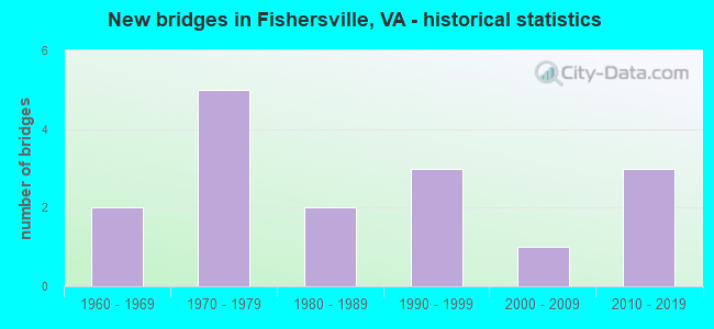
- New bridges - historical statistics
- 21960-1969
- 51970-1979
- 21980-1989
- 31990-1999
- 12000-2009
- 32010-2019


- Bridge Condition - Deck
- 20.0%Very good
- 40.0%Good
- 30.0%Satisfactory
- 10.0%Fair

- Bridge Condition - Superstructure
- 20.0%Very good
- 40.0%Good
- 40.0%Satisfactory

- Bridge Condition - Substructure
- 10.0%Very good
- 40.0%Good
- 40.0%Satisfactory
- 10.0%Fair

- Bridge Condition - Channel
- 44.4%Very good
- 11.1%Good
- 33.3%Fair
- 11.1%Poor

- Bridge Condition - Culverts
- 33.3%Good
- 33.3%Satisfactory
- 33.3%Fair
Find on map >> Show street view
Structure Number: 1743, Location: 0.50 RT285 - 2.53 RT 340 (Lat: 38.077742, Lng: -78.983283), Route carried "on" structure: Interstate 64, Year Built: 1969, Status: Open, Structure Length: 0.73m (2.40ft), Average Daily Traffic: 35,883 (year 2020), Truck Traffic: 11%, Average Future Daily Traffic: 50,236 (year 2040), Design Load: HS 20, Features Intersected: GOOSE CREEK
Minimum Vertical Clearance: 30+ m (98+ ft), Kilometerpoint: 147.964, Lanes on structure: 4, Base Highway Network: Yes, Owner: State Highway Agency, Approaching Roadway Width: 25.6m (84.0ft), Skew: 3 degrees, Material/Design: Concrete, Design/Construction: Culvert, Number Of Spans In Main Unit: 3, Length of Maximum Span: 2.3m (7.5ft)
Condition: Channel: Fair, Culverts: Fair, Operating Rating: 89.8 metric tons, Method Used To Determine Operating Rating: Field evaluation and documented engineering judgment, Inventory Rating: 88.9 metric tons, Method Used To Determine Inventory Rating: Field evaluation and documented engineering judgment, Structural Evaluation: Somewhat better than minimum adequacy, Waterway Adequacy: Better than present minimum criteria, Approach Roadway Alignment: Equal to present minimum criteria, Designated Inspection Frequency: Every 24 months, Inspection Date: January 2022
Find on map >> Show street view
Structure Number: 1746, Location: 2.03 RT 81 - 2.40 RT 608 (Lat: 38.108003, Lng: -79.019408), Route carried "on" structure: Interstate 64, Year Built: 1970, Status: Open, Structure Length: 9.45m (31.00ft), Average Daily Traffic: 19,092 (year 2020), Truck Traffic: 11%, Average Future Daily Traffic: 26,729 (year 2040), Design Load: HS 20+Mod, Features Intersected: CHRISTIANS CREEK
Minimum Vertical Clearance: 30+ m (98+ ft), Kilometerpoint: 143.330, Lanes on structure: 2, Base Highway Network: Yes, Owner: State Highway Agency, Approaching Roadway Width: 12.2m (40.0ft), Material/Design: Prestressed concrete, Design/Construction: Stringer/Multi-beam, Number Of Spans In Main Unit: 5, Length of Maximum Span: 18.9m (62.0ft), Curb-To-Curb Width: 12.2m (40.0ft), Out-to-Out Width: 13.4m (44.0ft)
Condition: Deck: Satisfactory, Superstructure: Satisfactory, Substructure: Satisfactory, Channel: Very good, Operating Rating: 80.7 metric tons, Method Used To Determine Operating Rating: Load and Resistance Factor (LRFR), Inventory Rating: 38.1 metric tons, Method Used To Determine Inventory Rating: Load and Resistance Factor (LRFR), Structural Evaluation: Equal to present minimum criteria, Deck Geometry: Better than present minimum criteria, Waterway Adequacy: Superior to present desirable criteria, Approach Roadway Alignment: Equal to present desirable criteria, Designated Inspection Frequency: Every 24 months, Inspection Date: Febuary 2021, Bridge Improvement Cost: $103,000, Total Project Cost: $108,000, Deck Structure Type: Concrete Cast-file-Place, Wearing Surface/Protective System: Wearing Surface: Epoxy Overlay
Find on map >> Show street view
Structure Number: 1747, Location: 2.03 RT I-81-2.40 RT 608 (Lat: 38.108578, Lng: -79.019197), Route carried "on" structure: Interstate 64, Year Built: 1970, Status: Open, Structure Length: 10.81m (35.47ft), Average Daily Traffic: 19,145 (year 2020), Truck Traffic: 11%, Average Future Daily Traffic: 26,803 (year 2040), Design Load: HS 20+Mod, Features Intersected: CHRISTIANS CREEK
Minimum Vertical Clearance: 30+ m (98+ ft), Kilometerpoint: 143.362, Lanes on structure: 2, Base Highway Network: Yes, Owner: State Highway Agency, Approaching Roadway Width: 12.2m (40.0ft), Material/Design: Prestressed concrete, Design/Construction: Stringer/Multi-beam, Number Of Spans In Main Unit: 5, Length of Maximum Span: 21.6m (70.9ft), Curb-To-Curb Width: 12.2m (40.0ft), Out-to-Out Width: 13.4m (44.0ft)
Condition: Deck: Satisfactory, Superstructure: Satisfactory, Substructure: Fair, Channel: Good, Operating Rating: 89.8 metric tons, Method Used To Determine Operating Rating: Load and Resistance Factor (LRFR), Inventory Rating: 40.8 metric tons, Method Used To Determine Inventory Rating: Load and Resistance Factor (LRFR), Structural Evaluation: Somewhat better than minimum adequacy, Deck Geometry: Better than present minimum criteria, Waterway Adequacy: Superior to present desirable criteria, Approach Roadway Alignment: Equal to present desirable criteria, Designated Inspection Frequency: Every 24 months, Inspection Date: Febuary 2021, Bridge Improvement Cost: $115,000, Total Project Cost: $121,000, Deck Structure Type: Concrete Cast-file-Place, Wearing Surface/Protective System: Wearing Surface: Epoxy Overlay
Find on map >> Show street view
Structure Number: 1857, Location: 0.04 TO 636 - 0.08 TO 637 (Lat: 38.113231, Lng: -79.011614), Route carried "on" structure: US 250, Year Built: 1986, Status: Open, Structure Length: 4.45m (14.60ft), Average Daily Traffic: 15,260 (year 2020), Truck Traffic: 1%, Average Future Daily Traffic: 21,364 (year 2040), Design Load: HS 20+Mod, Features Intersected: CHRISTIANS CREEK, Facility Carried by Structure: Jefferson Highway
Minimum Vertical Clearance: 30+ m (98+ ft), Kilometerpoint: 99.377, Lanes on structure: 4, Base Highway Network: Yes, Owner: State Highway Agency, Approaching Roadway Width: 20.7m (67.9ft), Skew: 20 degrees, Material/Design: Prestressed concrete, Design/Construction: Stringer/Multi-beam, Number Of Spans In Main Unit: 3, Length of Maximum Span: 14.6m (47.9ft), Curb-To-Curb Width: 25.8m (84.6ft), Out-to-Out Width: 26.8m (87.9ft)
Condition: Deck: Good, Superstructure: Good, Substructure: Good, Channel: Very good, Operating Rating: 85.3 metric tons, Method Used To Determine Operating Rating: Load and Resistance Factor (LRFR), Inventory Rating: 65.3 metric tons, Method Used To Determine Inventory Rating: Load and Resistance Factor (LRFR), Structural Evaluation: Better than present minimum criteria, Deck Geometry: Superior to present desirable criteria, Waterway Adequacy: Equal to present minimum criteria, Approach Roadway Alignment: Better than present minimum criteria, Designated Inspection Frequency: Every 24 months, Inspection Date: June 2020, Deck Structure Type: Concrete Precast Panels, Wearing Surface/Protective System: Wearing Surface: Monolithic Concrete, Deck Protection: Epoxy Coated Reinforcing
Find on map >> Show street view
Structure Number: 1874, Location: 0.08 RT 608N-0.06 RT 608S (Lat: 38.098206, Lng: -78.968208), Route carried "on" structure: US 250, Year Built: 1985, Status: Open, Structure Length: 0.76m (2.49ft), Average Daily Traffic: 12,566 (year 2020), Truck Traffic: 1%, Average Future Daily Traffic: 17,592 (year 2040), Design Load: HS 20+Mod, Features Intersected: WET WEATHER STREAM, Facility Carried by Structure: JEFFERSON HWY
Minimum Vertical Clearance: 5.18m (16.99ft), Kilometerpoint: 103.613, Lanes on structure: 4, Owner: State Highway Agency, Approaching Roadway Width: 22.3m (73.2ft), Skew: 3 degrees, Material/Design: Concrete, Design/Construction: Culvert, Number Of Spans In Main Unit: 2, Length of Maximum Span: 3.8m (12.5ft)
Condition: Channel: Poor, Culverts: Good, Operating Rating: 28.1 metric tons, Method Used To Determine Operating Rating: Field evaluation and documented engineering judgment, Inventory Rating: 16.3 metric tons, Method Used To Determine Inventory Rating: Field evaluation and documented engineering judgment, Structural Evaluation: Meets minimum limits, Waterway Adequacy: Equal to present minimum criteria, Approach Roadway Alignment: Better than present minimum criteria, Designated Inspection Frequency: Every 24 months, Inspection Date: December 2021
Find on map >> Show street view
Structure Number: 234, Location: 0.06 RT923N - 0.39 RT923S (Lat: 38.153450, Lng: -78.980442), Route carried "on" structure: County highway 792, Year Built: 1966, Status: Open, Structure Length: 0.94m (3.08ft), Average Daily Traffic: 460 (year 2020), Truck Traffic: 2%, Average Future Daily Traffic: 506 (year 2040), Design Load: HS 20, Features Intersected: POOR FARM DRAFT, Facility Carried by Structure: BALSLEY RD
Minimum Vertical Clearance: 30+ m (98+ ft), Kilometerpoint: 6.283, Lanes on structure: 2, Owner: State Highway Agency, Approaching Roadway Width: 6.1m (20.0ft), Skew: 4 degrees, Material/Design: Concrete, Design/Construction: Culvert, Number Of Spans In Main Unit: 2, Length of Maximum Span: 4.3m (14.1ft)
Condition: Channel: Fair, Culverts: Satisfactory, Operating Rating: 85.3 metric tons, Method Used To Determine Operating Rating: Load Factor (LF), Inventory Rating: 50.8 metric tons, Method Used To Determine Inventory Rating: Load Factor (LF), Structural Evaluation: Equal to present minimum criteria, Waterway Adequacy: Better than present minimum criteria, Approach Roadway Alignment: Better than present minimum criteria, Designated Inspection Frequency: Every 24 months, Inspection Date: August 2021
Find on map >> Show street view
Structure Number: 2368, Location: 0007F323 0025631 (Lat: 38.067642, Lng: -78.963953), Route carried "on" structure: County highway 834, Year Built: 1970, Status: Open, Structure Length: 9.52m (31.23ft), Average Daily Traffic: 1,450 (year 2020), Truck Traffic: 1%, Average Future Daily Traffic: 2,030 (year 2040), Design Load: HS 20+Mod, Features Intersected: RTE 64, Facility Carried by Structure: HICKORY HILL RD.
Minimum Vertical Clearance: 30+ m (98+ ft), Kilometerpoint: 0.307, Lanes on structure: 2, Lanes under structure: 4, Owner: State Highway Agency, Approaching Roadway Width: 7.3m (24.0ft), Skew: 2 degrees, Material/Design: Steel continuous, Design/Construction: Stringer/Multi-beam, Number Of Spans In Main Unit: 2, Number Of Approach Spans: 2, Length of Maximum Span: 33.9m (111.2ft), Curb or Sidewalk Widths: Left: 0.2m (0.7ft), Right: 0.2m (0.7ft), Curb-To-Curb Width: 8.1m (26.6ft), Out-to-Out Width: 9.3m (30.5ft)
Condition: Deck: Fair, Superstructure: Satisfactory, Substructure: Satisfactory, Operating Rating: 62.6 metric tons, Method Used To Determine Operating Rating: Load and Resistance Factor (LRFR), Inventory Rating: 48.1 metric tons, Method Used To Determine Inventory Rating: Load and Resistance Factor (LRFR), Structural Evaluation: Equal to present minimum criteria, Deck Geometry: Meets minimum limits, Underclear: Equal to present minimum criteria, Approach Roadway Alignment: Equal to present minimum criteria, Designated Inspection Frequency: Every 24 months, Inspection Date: April 2021, Bridge Improvement Cost: $29,000, Total Project Cost: $32,000, Deck Structure Type: Concrete Cast-file-Place, Wearing Surface/Protective System: Wearing Surface: Epoxy Overlay
Find on map >> Show street view
Structure Number: 23836, Location: 0.80 RT 1001- 0.08 RT 795 (Lat: 38.096375, Lng: -78.926219), Route carried "on" structure: County highway 640, Year Built: 1993, Status: Open, Structure Length: 4.34m (14.24ft), Average Daily Traffic: 3,208 (year 2020), Truck Traffic: 1%, Average Future Daily Traffic: 4,491 (year 2040), Design Load: HS 20+Mod, Features Intersected: CSX RAILWAY, Facility Carried by Structure: Old White BridgeRd
Minimum Vertical Clearance: 30+ m (98+ ft), Kilometerpoint: 5.995, Lanes on structure: 2, Owner: State Highway Agency, Approaching Roadway Width: 9.1m (29.9ft), Skew: 3 degrees, Material/Design: Steel continuous, Design/Construction: Stringer/Multi-beam, Number Of Spans In Main Unit: 3, Length of Maximum Span: 18.9m (62.0ft), Curb-To-Curb Width: 9.1m (29.9ft), Out-to-Out Width: 10.2m (33.5ft)
Condition: Deck: Good, Superstructure: Good, Substructure: Satisfactory, Operating Rating: 47.2 metric tons, Method Used To Determine Operating Rating: Load and Resistance Factor (LRFR), Inventory Rating: 36.3 metric tons, Method Used To Determine Inventory Rating: Load and Resistance Factor (LRFR), Structural Evaluation: Equal to present minimum criteria, Deck Geometry: Meets minimum limits, Underclear: Somewhat better than minimum adequacy, Approach Roadway Alignment: Equal to present desirable criteria, Designated Inspection Frequency: Every 24 months, Inspection Date: Febuary 2022, Deck Structure Type: Concrete Cast-file-Place, Wearing Surface/Protective System: Deck Protection: Epoxy Coated Reinforcing
Find on map >> Show street view
Structure Number: 23852, Location: 2.10 RT F218- 1.15 RT 637 (Lat: 38.096381, Lng: -79.031308), Route carried "on" structure: County highway 635, Year Built: 1992, Status: Open, Structure Length: 4.66m (15.29ft), Average Daily Traffic: 865 (year 2020), Truck Traffic: 1%, Average Future Daily Traffic: 1,211 (year 2040), Design Load: HS 20+Mod, Features Intersected: CHRISTIANS CREEK, Facility Carried by Structure: Barterbrook Rd
Minimum Vertical Clearance: 30+ m (98+ ft), Kilometerpoint: 10.187, Lanes on structure: 2, Owner: State Highway Agency, Approaching Roadway Width: 7.0m (23.0ft), Material/Design: Steel continuous, Design/Construction: Stringer/Multi-beam, Number Of Spans In Main Unit: 2, Length of Maximum Span: 22.4m (73.5ft), Curb-To-Curb Width: 8.5m (27.9ft), Out-to-Out Width: 9.5m (31.2ft)
Condition: Deck: Good, Superstructure: Good, Substructure: Good, Channel: Very good, Operating Rating: 33.6 metric tons, Method Used To Determine Operating Rating: Load and Resistance Factor (LRFR), Inventory Rating: 25.4 metric tons, Method Used To Determine Inventory Rating: Load and Resistance Factor (LRFR), Structural Evaluation: Equal to present minimum criteria, Deck Geometry: Somewhat better than minimum adequacy, Waterway Adequacy: Better than present minimum criteria, Approach Roadway Alignment: Better than present minimum criteria, Designated Inspection Frequency: Every 24 months, Inspection Date: March 2022, Deck Structure Type: Concrete Cast-file-Place, Wearing Surface/Protective System: Deck Protection: Epoxy Coated Reinforcing
Find on map >> Show street view
Structure Number: 25682, Location: 2.47 RT 635 - 0.01 RT 250 (Lat: 38.113450, Lng: -79.012789), Route carried "on" structure: County highway 637, Year Built: 1998, Status: Open, Structure Length: 2.74m (8.99ft), Average Daily Traffic: 254 (year 2013), Average Future Daily Traffic: 262 (year 2040), Features Intersected: CHRISTIANS CREEK, Facility Carried by Structure: JERICHO RD.
Minimum Vertical Clearance: 30+ m (98+ ft), Kilometerpoint: 6.508, Lanes on structure: 2, Owner: State Highway Agency, Approaching Roadway Width: 7.3m (24.0ft), Material/Design: Concrete continuous, Design/Construction: Slab, Number Of Spans In Main Unit: 2, Length of Maximum Span: 13.7m (44.9ft), Curb-To-Curb Width: 7.9m (25.9ft), Out-to-Out Width: 8.5m (27.9ft)
Condition: Deck: Satisfactory, Superstructure: Satisfactory, Substructure: Satisfactory, Channel: Fair, Operating Rating: 59.0 metric tons, Method Used To Determine Operating Rating: Load and Resistance Factor (LRFR), Inventory Rating: 45.4 metric tons, Method Used To Determine Inventory Rating: Load and Resistance Factor (LRFR), Structural Evaluation: Equal to present minimum criteria, Deck Geometry: Somewhat better than minimum adequacy, Waterway Adequacy: High priority of corrective action, Approach Roadway Alignment: Equal to present desirable criteria, Designated Inspection Frequency: Every 24 months, Inspection Date: October 2020, Deck Structure Type: Concrete Cast-file-Place, Wearing Surface/Protective System: Deck Protection: Epoxy Coated Reinforcing
Find on map >> Show street view
Structure Number: 29276, Location: 0.11 RT 631 - 0.50 RT 636 (Lat: 38.082697, Lng: -78.989236), Route carried "on" structure: State highway 285, Year Built: 2015, Status: Open, Structure Length: 6.46m (21.19ft), Average Daily Traffic: 10,414 (year 2020), Truck Traffic: 3%, Average Future Daily Traffic: 12,354 (year 2040), Design Load: HL 93, Features Intersected: I64, Facility Carried by Structure: TINKLING SPRING RD
Minimum Vertical Clearance: 30+ m (98+ ft), Kilometerpoint: 0.322, Lanes on structure: 4, Lanes under structure: 4, Owner: State Highway Agency, Approaching Roadway Width: 25.4m (83.3ft), Skew: 10 degrees, Material/Design: Prestressed concrete continuous, Design/Construction: Stringer/Multi-beam, Number Of Spans In Main Unit: 2, Length of Maximum Span: 32.3m (106.0ft), Curb or Sidewalk Widths: Left: 3.7m (12.1ft), Right: 0.0m, Curb-To-Curb Width: 25.4m (83.3ft), Out-to-Out Width: 29.5m (96.8ft)
Condition: Deck: Good, Superstructure: Good, Substructure: Good, Operating Rating: 89.8 metric tons, Method Used To Determine Operating Rating: Load and Resistance Factor (LRFR), Inventory Rating: 49.9 metric tons, Method Used To Determine Inventory Rating: Load and Resistance Factor (LRFR), Structural Evaluation: Better than present minimum criteria, Deck Geometry: Superior to present desirable criteria, Underclear: Superior to present desirable criteria, Approach Roadway Alignment: Equal to present minimum criteria, Designated Inspection Frequency: Every 24 months, Inspection Date: March 2020, Deck Structure Type: Concrete Cast-file-Place, Wearing Surface/Protective System: Deck Protection: Other Coated Reinforcing
Find on map >> Show street view
Structure Number: 29283, Location: 1.05 RT 285 - 0.75 RT 250 (Lat: 38.098861, Lng: -78.993692), Route carried "on" structure: County highway 636, Year Built: 2015, Status: Open, Structure Length: 4.35m (14.27ft), Average Daily Traffic: 10,103 (year 2020), Truck Traffic: 1%, Average Future Daily Traffic: 12,498 (year 2040), Design Load: HS 20+Mod, Features Intersected: BUCKINGHAM BRANCH RR, Facility Carried by Structure: LIFECORE DRIVE
Minimum Vertical Clearance: 30.18m (99.02ft), Kilometerpoint: 0.000, Lanes on structure: 2, Owner: State Highway Agency, Approaching Roadway Width: 9.8m (32.2ft), Skew: 4 degrees, Material/Design: Steel, Design/Construction: Stringer/Multi-beam, Number Of Spans In Main Unit: 1, Length of Maximum Span: 43.1m (141.4ft), Curb or Sidewalk Widths: Left: 0.0m, Right: 3.7m (12.1ft), Curb-To-Curb Width: 10.4m (34.1ft), Out-to-Out Width: 14.8m (48.6ft)
Condition: Deck: Very good, Superstructure: Very good, Substructure: Very good, Operating Rating: 63.5 metric tons, Method Used To Determine Operating Rating: Load and Resistance Factor (LRFR), Inventory Rating: 49.0 metric tons, Method Used To Determine Inventory Rating: Load and Resistance Factor (LRFR), Structural Evaluation: Equal to present desirable criteria, Deck Geometry: Meets minimum limits, Underclear: Equal to present minimum criteria, Approach Roadway Alignment: Equal to present desirable criteria, Designated Inspection Frequency: Every 24 months, Inspection Date: October 2021, Deck Structure Type: Concrete Cast-file-Place, Wearing Surface/Protective System: Deck Protection: Other Coated Reinforcing
Find on map >> Show street view
Structure Number: 29363, Location: 1.77 Rt 792 - 2.30 Rt 642 (Lat: 38.128519, Lng: -78.994600), Route carried "on" structure: County highway 794, Year Built: 2009, Status: Open, Structure Length: 2.29m (7.51ft), Average Daily Traffic: 161 (year 2013), Average Future Daily Traffic: 183 (year 2040), Design Load: HS 20+Mod, Features Intersected: Christian Creek, Facility Carried by Structure: Sangers Lane
Minimum Vertical Clearance: 30+ m (98+ ft), Kilometerpoint: 2.849, Lanes on structure: 2, Owner: State Highway Agency, Approaching Roadway Width: 5.7m (18.7ft), Material/Design: Prestressed concrete, Design/Construction: Box Beam or Girders - Multiple, Number Of Spans In Main Unit: 1, Length of Maximum Span: 22.1m (72.5ft), Curb-To-Curb Width: 8.2m (26.9ft), Out-to-Out Width: 9.2m (30.2ft)
Condition: Deck: Very good, Superstructure: Very good, Substructure: Good, Channel: Very good, Operating Rating: 57.2 metric tons, Method Used To Determine Operating Rating: Load and Resistance Factor (LRFR), Inventory Rating: 43.5 metric tons, Method Used To Determine Inventory Rating: Load and Resistance Factor (LRFR), Structural Evaluation: Better than present minimum criteria, Deck Geometry: Somewhat better than minimum adequacy, Waterway Adequacy: Somewhat better than minimum adequacy, Approach Roadway Alignment: Better than present minimum criteria, Designated Inspection Frequency: Every 24 months, Inspection Date: March 2022, Deck Structure Type: Other, Wearing Surface/Protective System: Wearing Surface: Bituminous, Membrane: Epoxy
Find on map >> Show street view
Structure Number: 2063, Location: 1.75 RT 635 - 0.80 RT 250 (Lat: 38.104472, Lng: -79.013478), Route carried "under" structure: Interstate 64, Year Built: 1970, Structure Length: 0. m, Average Daily Traffic: 45,000 (year 2017), Truck Traffic: 11%, Features Intersected: RTE 64, Facility Carried by Structure: JERICHO RD
Minimum Vertical Clearance: 5.11m (16.77ft), Kilometerpoint: 143.957, Lanes on structure: 2, Lanes under structure: 4, Material/Design: Steel, Design/Construction: Stringer/Multi-beam, Length of Maximum Span: 30.8m (101.0ft)
Find on map >> Show street view
Structure Number: 2368, Location: 0007F323 0025631 (Lat: 38.067642, Lng: -78.963953), Route carried "under" structure: Interstate 64, Year Built: 1970, Structure Length: 0. m, Average Daily Traffic: 42,000 (year 2018), Truck Traffic: 11%, Features Intersected: RTE 64, Facility Carried by Structure: HICKORY HILL RD.
Minimum Vertical Clearance: 5.66m (18.57ft), Kilometerpoint: 150.071, Lanes on structure: 2, Lanes under structure: 4, Material/Design: Steel continuous, Design/Construction: Stringer/Multi-beam, Length of Maximum Span: 33.9m (111.2ft)
Find on map >> Show street view
Structure Number: 29276, Location: 0.11 RT 631 - 0.50 RT 636 (Lat: 38.082697, Lng: -78.989236), Route carried "under" structure: Interstate 64, Year Built: 2015, Structure Length: 0. m, Average Daily Traffic: 42,000 (year 2018), Truck Traffic: 11%, Features Intersected: I64, Facility Carried by Structure: TINKLING SPRING RD
Minimum Vertical Clearance: 5.59m (18.34ft), Kilometerpoint: 147.255, Lanes on structure: 4, Lanes under structure: 4, Material/Design: Prestressed concrete continuous, Design/Construction: Stringer/Multi-beam, Length of Maximum Span: 32.3m (106.0ft)