Bridge Statistics for Firestone, Colorado (CO)
Condition, Traffic, Stress, Structural Evaluation, Project Costs
- National Bridge Inventory (NBI) Statistics
- 20Number of bridges
- 217ft / 65.6mTotal length
- $2,629,000Total costs
- 240,793Total average daily traffic
- 24,300Total average daily truck traffic
- National Bridge Inventory (NBI) Registered Bridges for Firestone
- No street view available for this location
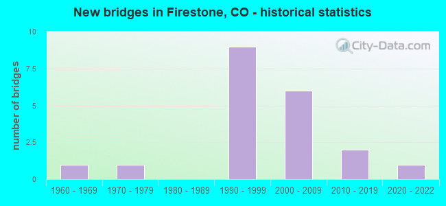
- New bridges - historical statistics
- 11960-1969
- 11970-1979
- 91990-1999
- 62000-2009
- 22010-2019
- 12020-2022


- Bridge Condition - Deck
- 11.8%Very good
- 29.4%Good
- 41.2%Satisfactory
- 17.6%Poor

- Bridge Condition - Superstructure
- 23.5%Very good
- 29.4%Good
- 29.4%Satisfactory
- 17.6%Fair

- Bridge Condition - Substructure
- 23.5%Very good
- 41.2%Good
- 29.4%Satisfactory
- 5.9%Fair

- Bridge Condition - Channel
- 31.3%Very good
- 37.5%Good
- 31.3%Satisfactory
Find on map >> Show street view
Structure Number: D-16-CG, Location: 1.1 MI W OF JCT I 25 (Lat: 40.160614, Lng: -105.008394), Route carried "on" structure: State highway 119C, Year Built: 1973, Status: Open, Structure Length: 6.49m (21.29ft), Average Daily Traffic: 15,500 (year 2020), Truck Traffic: 6%, Average Future Daily Traffic: 21,855 (year 2040), Design Load: HS 20+Mod, Features Intersected: ST VRAIN CREEK, Facility Carried by Structure: SH 119 S/WBND
Minimum Vertical Clearance: 30+ m (98+ ft), Kilometerpoint: 4.635, Lanes on structure: 2, Base Highway Network: Yes, Owner: State Highway Agency, Approaching Roadway Width: 12.2m (40.0ft), Skew: 3 degrees, Material/Design: Concrete continuous, Design/Construction: Tee Beam, Number Of Spans In Main Unit: 7, Length of Maximum Span: 9.1m (29.9ft), Curb-To-Curb Width: 12.8m (42.0ft), Out-to-Out Width: 13.6m (44.6ft)
Condition: Deck: Satisfactory, Superstructure: Satisfactory, Substructure: Satisfactory, Channel: Satisfactory, Operating Rating: 46.4 metric tons, Method Used To Determine Operating Rating: Load Factor (LF), Inventory Rating: 27.8 metric tons, Method Used To Determine Inventory Rating: Load Factor (LF), Structural Evaluation: Equal to present minimum criteria, Deck Geometry: Equal to present desirable criteria, Waterway Adequacy: Meets minimum limits, Approach Roadway Alignment: Equal to present desirable criteria, Designated Inspection Frequency: Every 24 months, Inspection Date: September 2021, Deck Structure Type: Concrete Cast-file-Place, Wearing Surface/Protective System: Wearing Surface: Bituminous, Membrane: Preformed Fabric
Find on map >> Show street view
Structure Number: D-16-DR, Location: 1.1 MI W OF JCT I-25 (Lat: 40.160422, Lng: -105.008647), Route carried "on" structure: State highway 119C, Year Built: 2008, Status: Open, Structure Length: 7.40m (24.28ft), Average Daily Traffic: 15,500 (year 2020), Truck Traffic: 6%, Average Future Daily Traffic: 21,855 (year 2040), Design Load: HS 25 or greater, Features Intersected: ST VRAIN CREEK, Facility Carried by Structure: SH 119 N/EBND
Minimum Vertical Clearance: 30+ m (98+ ft), Kilometerpoint: 4.612, Lanes on structure: 2, Base Highway Network: Yes, Owner: State Highway Agency, Approaching Roadway Width: 14.6m (47.9ft), Skew: 10 degrees, Material/Design: Prestressed concrete, Design/Construction: Box Beam or Girders - Multiple, Number Of Spans In Main Unit: 4, Length of Maximum Span: 18.3m (60.0ft), Curb-To-Curb Width: 15.8m (51.8ft), Out-to-Out Width: 16.8m (55.1ft)
Condition: Deck: Good, Superstructure: Good, Substructure: Good, Channel: Satisfactory, Operating Rating: 76.1 metric tons, Method Used To Determine Operating Rating: Load Factor (LF), Inventory Rating: 45.7 metric tons, Method Used To Determine Inventory Rating: Load Factor (LF), Structural Evaluation: Better than present minimum criteria, Deck Geometry: Superior to present desirable criteria, Waterway Adequacy: Better than present minimum criteria, Approach Roadway Alignment: Equal to present desirable criteria, Length Of Structure Improvement: 6.46m (21.19ft), Designated Inspection Frequency: Every 24 months, Inspection Date: September 2021, Bridge Improvement Cost: $1,519,000, Roadway Improvement Cost: $152,000, Total Project Cost: $2,279,000, Deck Structure Type: Concrete Cast-file-Place, Wearing Surface/Protective System: Wearing Surface: Bituminous, Membrane: Built-up
Find on map >> Show street view
Structure Number: D-17-DI, Location: DEL CAMINO INTRCHG (Lat: 40.160289, Lng: -104.978600), Route carried "on" structure: Interstate 25A, Year Built: 1998, Status: Open, Structure Length: 7.36m (24.15ft), Average Daily Traffic: 45,500 (year 2020), Truck Traffic: 9%, Average Future Daily Traffic: 68,705 (year 2040), Design Load: HS 20, Features Intersected: SH 119 ML, Facility Carried by Structure: I 25 ML NBND
Minimum Vertical Clearance: 30+ m (98+ ft), Kilometerpoint: 386.138, Lanes on structure: 3, Lanes under structure: 7, Base Highway Network: Yes, Owner: State Highway Agency, Approaching Roadway Width: 18.0m (59.1ft), Skew: 10 degrees, Material/Design: Prestressed concrete continuous, Design/Construction: Stringer/Multi-beam, Number Of Spans In Main Unit: 3, Length of Maximum Span: 35.7m (117.1ft), Curb-To-Curb Width: 18.0m (59.1ft), Out-to-Out Width: 18.7m (61.4ft)
Condition: Deck: Good, Superstructure: Very good, Substructure: Good, Inventory Rating: 53.4 metric tons, Method Used To Determine Inventory Rating: Load Factor (LF), Structural Evaluation: Better than present minimum criteria, Deck Geometry: Better than present minimum criteria, Underclear: Somewhat better than minimum adequacy, Approach Roadway Alignment: Equal to present desirable criteria, Designated Inspection Frequency: Every 24 months, Inspection Date: June 2021, Deck Structure Type: Concrete Cast-file-Place, Wearing Surface/Protective System: Wearing Surface: Bituminous, Membrane: Built-up, Deck Protection: Epoxy Coated Reinforcing
Find on map >> Show street view
Structure Number: D-17-DJ, Location: 3 MI SO OF JCT SH 66 (Lat: 40.160286, Lng: -104.979014), Route carried "on" structure: Interstate 25A, Year Built: 1998, Status: Open, Structure Length: 7.36m (24.15ft), Average Daily Traffic: 45,500 (year 2020), Truck Traffic: 9%, Average Future Daily Traffic: 68,705 (year 2040), Design Load: HS 20, Features Intersected: SH 119 ML, Facility Carried by Structure: I 25 ML SBND
Minimum Vertical Clearance: 30+ m (98+ ft), Kilometerpoint: 386.140, Lanes on structure: 3, Lanes under structure: 7, Base Highway Network: Yes, Owner: State Highway Agency, Approaching Roadway Width: 18.0m (59.1ft), Skew: 10 degrees, Material/Design: Prestressed concrete continuous, Design/Construction: Stringer/Multi-beam, Number Of Spans In Main Unit: 3, Length of Maximum Span: 35.7m (117.1ft), Curb-To-Curb Width: 18.0m (59.1ft), Out-to-Out Width: 18.7m (61.4ft)
Condition: Deck: Good, Superstructure: Good, Substructure: Good, Inventory Rating: 53.4 metric tons, Method Used To Determine Inventory Rating: Load Factor (LF), Structural Evaluation: Better than present minimum criteria, Deck Geometry: Better than present minimum criteria, Underclear: Equal to present minimum criteria, Approach Roadway Alignment: Equal to present desirable criteria, Designated Inspection Frequency: Every 24 months, Inspection Date: June 2021, Deck Structure Type: Concrete Cast-file-Place, Wearing Surface/Protective System: Wearing Surface: Bituminous, Membrane: Built-up, Deck Protection: Epoxy Coated Reinforcing
Find on map >> Show street view
Structure Number: D-17-FK, Location: 3.8 MI E OF JCT I 25 (Lat: 40.204133, Lng: -104.907522), Route carried "on" structure: State highway 66B, Year Built: 2013, Status: Open, Structure Length: 8.09m (26.54ft), Average Daily Traffic: 12,000 (year 2020), Truck Traffic: 9%, Average Future Daily Traffic: 17,640 (year 2040), Design Load: HL 93, Features Intersected: ST VRAIN River, Facility Carried by Structure: SH 66 ML
Minimum Vertical Clearance: 30+ m (98+ ft), Kilometerpoint: 29.298, Lanes on structure: 2, Base Highway Network: Yes, Owner: State Highway Agency, Approaching Roadway Width: 13.4m (44.0ft), Material/Design: Prestressed concrete continuous, Design/Construction: Stringer/Multi-beam, Number Of Spans In Main Unit: 2, Length of Maximum Span: 40.1m (131.6ft), Curb-To-Curb Width: 13.4m (44.0ft), Out-to-Out Width: 14.3m (46.9ft)
Condition: Deck: Good, Superstructure: Very good, Substructure: Very good, Channel: Good, Operating Rating: 59.3 metric tons, Method Used To Determine Operating Rating: Load and Resistance Factor (LRFR), Inventory Rating: 33.5 metric tons, Method Used To Determine Inventory Rating: Load and Resistance Factor (LRFR), Structural Evaluation: Equal to present desirable criteria, Deck Geometry: Equal to present minimum criteria, Waterway Adequacy: Equal to present desirable criteria, Approach Roadway Alignment: Equal to present desirable criteria, Designated Inspection Frequency: Every 24 months, Inspection Date: December 2021, Deck Structure Type: Concrete Precast Panels, Wearing Surface/Protective System: Wearing Surface: Bituminous, Membrane: Built-up, Deck Protection: Epoxy Coated Reinforcing
Find on map >> Show street view
Structure Number: FRSTN-FIRBLVDGH, Location: 0.1 mi W of CR 111 (Lat: 40.160583, Lng: -104.963028), Route carried "on" structure: City street , Year Built: 2020, Status: Open, Structure Length: 2.06m (6.76ft), Average Daily Traffic: 750 (year 2012), Truck Traffic: 1%, Average Future Daily Traffic: 1,750 (year 2032), Design Load: HL 93, Features Intersected: GODDING HOLLOW, Facility Carried by Structure: FIRESTONE BLVD.
Minimum Vertical Clearance: 30+ m (98+ ft), Kilometerpoint: 3.172, Lanes on structure: 4, Owner: Town or Township Highway Agency, Approaching Roadway Width: 21.9m (71.9ft), Skew: 2 degrees, Material/Design: Concrete, Design/Construction: Culvert, Number Of Spans In Main Unit: 5, Length of Maximum Span: 3.9m (12.8ft), Out-to-Out Width: 40.1m (131.6ft)
Condition: Channel: Very good, Culverts: Good, Operating Rating: 43.7 metric tons, Method Used To Determine Operating Rating: Load and Resistance Factor Rating (LRFR) rating reported by rating factor(RF) method using HL-93 loadings, Inventory Rating: 33.7 metric tons, Method Used To Determine Inventory Rating: Load and Resistance Factor Rating (LRFR) rating reported by rating factor(RF) method using HL-93 loadings, Structural Evaluation: Better than present minimum criteria, Waterway Adequacy: Equal to present desirable criteria, Approach Roadway Alignment: Equal to present desirable criteria, Designated Inspection Frequency: Every 24 months, Inspection Date: July 2020
Find on map >> Show street view
Structure Number: FRSTN-MCCLURE, Location: 110 ft E of Colorado BLVD (Lat: 40.109514, Lng: -104.941597), Route carried "on" structure: City street , Year Built: 2018, Status: Open, Structure Length: 1.74m (5.71ft), Average Daily Traffic: 3,359 (year 2020), Truck Traffic: 11%, Average Future Daily Traffic: 4,770 (year 2040), Design Load: HL 93, Features Intersected: Unnamed stream, Facility Carried by Structure: McClure Ave
Minimum Vertical Clearance: 30+ m (98+ ft), Kilometerpoint: 2.947, Lanes on structure: 3, Owner: Town or Township Highway Agency, Approaching Roadway Width: 12.2m (40.0ft), Material/Design: Steel, Design/Construction: Stringer/Multi-beam, Number Of Spans In Main Unit: 1, Length of Maximum Span: 16.2m (53.1ft), Curb or Sidewalk Widths: Left: 2.0m (6.6ft), Right: 0.5m (1.6ft), Curb-To-Curb Width: 12.2m (40.0ft), Out-to-Out Width: 15.1m (49.5ft)
Condition: Deck: Very good, Superstructure: Very good, Substructure: Very good, Channel: Very good, Operating Rating: 38.9 metric tons, Method Used To Determine Operating Rating: Load and Resistance Factor Rating (LRFR) rating reported by rating factor(RF) method using HL-93 loadings, Inventory Rating: 29.2 metric tons, Method Used To Determine Inventory Rating: Load and Resistance Factor Rating (LRFR) rating reported by rating factor(RF) method using HL-93 loadings, Structural Evaluation: Better than present minimum criteria, Deck Geometry: Meets minimum limits, Waterway Adequacy: Better than present minimum criteria, Approach Roadway Alignment: Equal to present desirable criteria, Designated Inspection Frequency: Every 24 months, Inspection Date: March 2022, Deck Structure Type: Concrete Cast-file-Place, Wearing Surface/Protective System: Wearing Surface: Monolithic Concrete
Find on map >> Show street view
Structure Number: FRSTN20.0_15.0A, Location: 0.7 Mi E of Co Rd 15 (Lat: 40.131139, Lng: -104.908444), Route carried "on" structure: City street , Year Built: 1994, Status: Open, Structure Length: 0.78m (2.56ft), Average Daily Traffic: 2,760 (year 2020), Truck Traffic: 30%, Average Future Daily Traffic: 3,919 (year 2040), Design Load: HS 20, Features Intersected: Sullivan Ditch, Facility Carried by Structure: County Road 20
Minimum Vertical Clearance: 30+ m (98+ ft), Kilometerpoint: 2.683, Lanes on structure: 2, Owner: Town or Township Highway Agency, Approaching Roadway Width: 7.3m (24.0ft), Material/Design: Steel, Design/Construction: Stringer/Multi-beam, Number Of Spans In Main Unit: 1, Length of Maximum Span: 7.1m (23.3ft), Curb-To-Curb Width: 9.6m (31.5ft), Out-to-Out Width: 9.8m (32.2ft)
Condition: Deck: Poor, Superstructure: Fair, Substructure: Satisfactory, Channel: Very good, Operating Rating: 39.8 metric tons, Method Used To Determine Operating Rating: Load Factor (LF), Inventory Rating: 23.9 metric tons, Method Used To Determine Inventory Rating: Load Factor (LF), Structural Evaluation: Somewhat better than minimum adequacy, Deck Geometry: Meets minimum limits, Waterway Adequacy: Better than present minimum criteria, Approach Roadway Alignment: Equal to present desirable criteria, Designated Inspection Frequency: Every 24 months, Inspection Date: March 2022, Deck Structure Type: Corrugated Steel, Wearing Surface/Protective System: Wearing Surface: Bituminous
Find on map >> Show street view
Structure Number: FRSTN26.0-13.0A, Location: 0.8 Mi E of Co Rd 13 (Lat: 40.175361, Lng: -104.924944), Route carried "on" structure: County highway , Year Built: 2003, Status: Open, Structure Length: 1.11m (3.64ft), Average Daily Traffic: 1,350 (year 2020), Truck Traffic: 44%, Average Future Daily Traffic: 1,917 (year 2040), Design Load: HS 20, Features Intersected: Last Chance Ditch, Facility Carried by Structure: County Road 26
Minimum Vertical Clearance: 30+ m (98+ ft), Kilometerpoint: 1.439, Lanes on structure: 2, Owner: Town or Township Highway Agency, Approaching Roadway Width: 7.6m (24.9ft), Skew: 4 degrees, Material/Design: Steel, Design/Construction: Stringer/Multi-beam, Number Of Spans In Main Unit: 1, Length of Maximum Span: 10.1m (33.1ft), Curb-To-Curb Width: 10.7m (35.1ft), Out-to-Out Width: 11.0m (36.1ft)
Condition: Deck: Poor, Superstructure: Fair, Substructure: Good, Channel: Very good, Operating Rating: 67.4 metric tons, Method Used To Determine Operating Rating: Load Factor (LF), Inventory Rating: 40.4 metric tons, Method Used To Determine Inventory Rating: Load Factor (LF), Structural Evaluation: Somewhat better than minimum adequacy, Deck Geometry: Equal to present minimum criteria, Waterway Adequacy: Equal to present desirable criteria, Approach Roadway Alignment: Equal to present desirable criteria, Designated Inspection Frequency: Every 24 months, Inspection Date: March 2020, Deck Structure Type: Corrugated Steel, Wearing Surface/Protective System: Wearing Surface: Bituminous
Find on map >> Show street view
Structure Number: WEL009.5-024.5A, Location: 1 MI N of SH 119 (Lat: 40.174722, Lng: -104.979444), Route carried "on" structure: City street , Year Built: 1999, Status: Open, Structure Length: 9.20m (30.18ft), Average Daily Traffic: 8,682 (year 2021), Truck Traffic: 23%, Average Future Daily Traffic: 12,328 (year 2041), Design Load: HS 20, Features Intersected: St Vrain River, Facility Carried by Structure: County Road 9.5
Minimum Vertical Clearance: 30+ m (98+ ft), Kilometerpoint: 0.739, Lanes on structure: 2, Owner: Town or Township Highway Agency, Approaching Roadway Width: 13.1m (43.0ft), Material/Design: Prestressed concrete continuous, Design/Construction: Stringer/Multi-beam, Number Of Spans In Main Unit: 4, Length of Maximum Span: 25.9m (85.0ft), Curb-To-Curb Width: 13.2m (43.3ft), Out-to-Out Width: 14.1m (46.3ft)
Condition: Deck: Satisfactory, Superstructure: Good, Substructure: Good, Channel: Satisfactory, Operating Rating: 70.9 metric tons, Method Used To Determine Operating Rating: Load Factor (LF), Inventory Rating: 41.0 metric tons, Method Used To Determine Inventory Rating: Load Factor (LF), Structural Evaluation: Better than present minimum criteria, Deck Geometry: Somewhat better than minimum adequacy, Waterway Adequacy: Equal to present desirable criteria, Approach Roadway Alignment: Equal to present desirable criteria, Designated Inspection Frequency: Every 24 months, Inspection Date: March 2020, Deck Structure Type: Concrete Cast-file-Place, Wearing Surface/Protective System: Wearing Surface: Bituminous, Membrane: Built-up, Deck Protection: Epoxy Coated Reinforcing
Find on map >> Show street view
Structure Number: WEL013.0-044.0B, Location: 0.4 Mi N of Co Rd 44 (Lat: 40.313889, Lng: -104.941750), Route carried "on" structure: County highway , Year Built: 1966, Status: Open, Structure Length: 1.83m (6.00ft), Average Daily Traffic: 4,428 (year 2021), Truck Traffic: 21%, Average Future Daily Traffic: 6,288 (year 2041), Design Load: HS 20, Features Intersected: Little Thompson River, Facility Carried by Structure: County Road 13
Minimum Vertical Clearance: 30+ m (98+ ft), Kilometerpoint: 10.206, Lanes on structure: 2, Owner: County Highway Agency, Approaching Roadway Width: 7.3m (24.0ft), Material/Design: Steel, Design/Construction: Stringer/Multi-beam, Number Of Spans In Main Unit: 1, Length of Maximum Span: 17.8m (58.4ft), Curb-To-Curb Width: 7.5m (24.6ft), Out-to-Out Width: 7.6m (24.9ft)
Condition: Deck: Satisfactory, Superstructure: Satisfactory, Substructure: Fair, Channel: Satisfactory, Operating Rating: 45.4 metric tons, Method Used To Determine Operating Rating: Load Factor (LF), Inventory Rating: 27.2 metric tons, Method Used To Determine Inventory Rating: Load Factor (LF), Structural Evaluation: Somewhat better than minimum adequacy, Deck Geometry: High priority of replacement, Waterway Adequacy: Better than present minimum criteria, Approach Roadway Alignment: Equal to present desirable criteria, Length Of Structure Improvement: 1.83m (6.00ft), Designated Inspection Frequency: Every 24 months, Inspection Date: May 2020, Bridge Improvement Cost: $319,000, Roadway Improvement Cost: $32,000, Total Project Cost: $350,000 ( Estimate for 2018), Deck Structure Type: Corrugated Steel, Wearing Surface/Protective System: Wearing Surface: Bituminous
Find on map >> Show street view
Structure Number: WEL013.0_026.0A, Location: 0.5 Mi N of Co Rd 26 (Lat: 40.182222, Lng: -104.941944), Route carried "on" structure: County highway , Year Built: 2004, Status: Open, Structure Length: 6.28m (20.60ft), Average Daily Traffic: 7,325 (year 2020), Truck Traffic: 26%, Average Future Daily Traffic: 10,402 (year 2040), Design Load: HS 20, Features Intersected: St. Vrain Creek, Facility Carried by Structure: County Road 13
Minimum Vertical Clearance: 30+ m (98+ ft), Kilometerpoint: 5.623, Lanes on structure: 2, Owner: County Highway Agency, Approaching Roadway Width: 7.3m (24.0ft), Material/Design: Prestressed concrete, Design/Construction: Stringer/Multi-beam, Number Of Spans In Main Unit: 3, Length of Maximum Span: 22.3m (73.2ft), Curb-To-Curb Width: 19.8m (65.0ft), Out-to-Out Width: 20.7m (67.9ft)
Condition: Deck: Good, Superstructure: Very good, Substructure: Very good, Channel: Very good, Operating Rating: 53.8 metric tons, Method Used To Determine Operating Rating: Load Factor (LF), Inventory Rating: 29.1 metric tons, Method Used To Determine Inventory Rating: Load Factor (LF), Structural Evaluation: Better than present minimum criteria, Deck Geometry: Superior to present desirable criteria, Waterway Adequacy: Equal to present desirable criteria, Approach Roadway Alignment: Equal to present desirable criteria, Designated Inspection Frequency: Every 24 months, Inspection Date: March 2020, Deck Structure Type: Concrete Cast-file-Place, Wearing Surface/Protective System: Wearing Surface: Bituminous, Membrane: Preformed Fabric, Deck Protection: Epoxy Coated Reinforcing
Find on map >> Show street view
Structure Number: WEL017.0_022.0A, Location: 0.2 Mi N of Co Rd 22 (Lat: 40.147750, Lng: -104.904639), Route carried "on" structure: County highway , Year Built: 2002, Status: Open, Structure Length: 0.87m (2.85ft), Average Daily Traffic: 173 (year 2020), Truck Traffic: 35%, Average Future Daily Traffic: 246 (year 2040), Design Load: HS 20, Features Intersected: Sullivan Ditch, Facility Carried by Structure: County Road 17
Minimum Vertical Clearance: 30+ m (98+ ft), Kilometerpoint: 0.256, Lanes on structure: 2, Owner: County Highway Agency, Approaching Roadway Width: 7.3m (24.0ft), Skew: 1 degrees, Material/Design: Steel, Design/Construction: Stringer/Multi-beam, Number Of Spans In Main Unit: 1, Length of Maximum Span: 8.0m (26.2ft), Curb-To-Curb Width: 9.5m (31.2ft), Out-to-Out Width: 9.8m (32.2ft)
Condition: Deck: Satisfactory, Superstructure: Good, Substructure: Good, Channel: Good, Operating Rating: 66.6 metric tons, Method Used To Determine Operating Rating: Load Factor (LF), Inventory Rating: 39.8 metric tons, Method Used To Determine Inventory Rating: Load Factor (LF), Structural Evaluation: Better than present minimum criteria, Deck Geometry: Equal to present minimum criteria, Waterway Adequacy: Better than present minimum criteria, Approach Roadway Alignment: Equal to present desirable criteria, Designated Inspection Frequency: Every 24 months, Inspection Date: March 2020, Deck Structure Type: Corrugated Steel, Wearing Surface/Protective System: Wearing Surface: Gravel
Find on map >> Show street view
Structure Number: WEL017.0_022.0B, Location: 0.4 Mi North of Co Rd 22 (Lat: 40.150778, Lng: -104.904611), Route carried "on" structure: County highway , Year Built: 2000, Status: Open, Structure Length: 0.93m (3.05ft), Average Daily Traffic: 199 (year 2020), Truck Traffic: 34%, Average Future Daily Traffic: 283 (year 2040), Design Load: HS 20, Features Intersected: Sullivan Ditch, Facility Carried by Structure: County Road 17
Minimum Vertical Clearance: 30+ m (98+ ft), Kilometerpoint: 0.592, Lanes on structure: 2, Owner: County Highway Agency, Approaching Roadway Width: 8.2m (26.9ft), Skew: 3 degrees, Material/Design: Steel, Design/Construction: Stringer/Multi-beam, Number Of Spans In Main Unit: 1, Length of Maximum Span: 8.1m (26.6ft), Curb-To-Curb Width: 9.5m (31.2ft), Out-to-Out Width: 9.8m (32.2ft)
Condition: Deck: Satisfactory, Superstructure: Good, Substructure: Good, Channel: Good, Operating Rating: 63.1 metric tons, Method Used To Determine Operating Rating: Load Factor (LF), Inventory Rating: 37.8 metric tons, Method Used To Determine Inventory Rating: Load Factor (LF), Structural Evaluation: Better than present minimum criteria, Deck Geometry: Equal to present minimum criteria, Waterway Adequacy: Better than present minimum criteria, Approach Roadway Alignment: Equal to present desirable criteria, Designated Inspection Frequency: Every 24 months, Inspection Date: March 2020, Deck Structure Type: Corrugated Steel, Wearing Surface/Protective System: Wearing Surface: Gravel
Find on map >> Show street view
Structure Number: WEL019.0-022.0A, Location: 0.5 Mi N of Co Rd 22 (Lat: 40.154139, Lng: -104.885917), Route carried "on" structure: County highway , Year Built: 1993, Status: Open, Structure Length: 1.09m (3.58ft), Average Daily Traffic: 3,447 (year 2020), Truck Traffic: 35%, Average Future Daily Traffic: 4,895 (year 2040), Design Load: HS 20, Features Intersected: Sullivan Ditch, Facility Carried by Structure: County Road 19
Minimum Vertical Clearance: 30+ m (98+ ft), Kilometerpoint: 6.572, Lanes on structure: 2, Owner: County Highway Agency, Approaching Roadway Width: 7.6m (24.9ft), Skew: 3 degrees, Material/Design: Steel, Design/Construction: Stringer/Multi-beam, Number Of Spans In Main Unit: 1, Length of Maximum Span: 10.0m (32.8ft), Curb-To-Curb Width: 9.6m (31.5ft), Out-to-Out Width: 9.8m (32.2ft)
Condition: Deck: Very good, Superstructure: Satisfactory, Substructure: Satisfactory, Channel: Good, Operating Rating: 82.2 metric tons, Method Used To Determine Operating Rating: Load Factor (LF), Inventory Rating: 49.2 metric tons, Method Used To Determine Inventory Rating: Load Factor (LF), Structural Evaluation: Equal to present minimum criteria, Deck Geometry: Meets minimum limits, Waterway Adequacy: Equal to present desirable criteria, Approach Roadway Alignment: Equal to present desirable criteria, Designated Inspection Frequency: Every 24 months, Inspection Date: March 2020, Deck Structure Type: Corrugated Steel, Wearing Surface/Protective System: Wearing Surface: Bituminous
Find on map >> Show street view
Structure Number: WEL022.0-021.0A, Location: 1.0 Mi E of Co Rd 19 (Lat: 40.145361, Lng: -104.865694), Route carried "on" structure: County highway , Year Built: 1993, Status: Open, Structure Length: 1.11m (3.64ft), Average Daily Traffic: 198 (year 2020), Truck Traffic: 57%, Average Future Daily Traffic: 281 (year 2040), Design Load: HS 20, Features Intersected: Sullivan Ditch, Facility Carried by Structure: County Road 22
Minimum Vertical Clearance: 30+ m (98+ ft), Kilometerpoint: 4.950, Lanes on structure: 2, Owner: County Highway Agency, Approaching Roadway Width: 7.0m (23.0ft), Skew: 4 degrees, Material/Design: Steel, Design/Construction: Stringer/Multi-beam, Number Of Spans In Main Unit: 1, Length of Maximum Span: 9.8m (32.2ft), Curb-To-Curb Width: 9.4m (30.8ft), Out-to-Out Width: 9.7m (31.8ft)
Condition: Deck: Satisfactory, Superstructure: Satisfactory, Substructure: Satisfactory, Channel: Good, Operating Rating: 56.1 metric tons, Method Used To Determine Operating Rating: Load Factor (LF), Inventory Rating: 33.7 metric tons, Method Used To Determine Inventory Rating: Load Factor (LF), Structural Evaluation: Equal to present minimum criteria, Deck Geometry: Equal to present minimum criteria, Waterway Adequacy: Better than present minimum criteria, Approach Roadway Alignment: Equal to present desirable criteria, Designated Inspection Frequency: Every 24 months, Inspection Date: March 2020, Deck Structure Type: Corrugated Steel, Wearing Surface/Protective System: Wearing Surface: Gravel
Find on map >> Show street view
Structure Number: WEL022.0_017.0A, Location: 0.1 Mi E of Co Rd 17 (Lat: 40.145639, Lng: -104.901444), Route carried "on" structure: County highway , Year Built: 2002, Status: Open, Structure Length: 0.94m (3.08ft), Average Daily Traffic: 309 (year 2020), Truck Traffic: 35%, Average Future Daily Traffic: 439 (year 2040), Design Load: HS 20, Features Intersected: Sullivan Ditch, Facility Carried by Structure: County Road 22
Minimum Vertical Clearance: 30+ m (98+ ft), Kilometerpoint: 1.968, Lanes on structure: 2, Owner: County Highway Agency, Approaching Roadway Width: 7.9m (25.9ft), Skew: 3 degrees, Material/Design: Steel, Design/Construction: Stringer/Multi-beam, Number Of Spans In Main Unit: 1, Length of Maximum Span: 8.1m (26.6ft), Curb-To-Curb Width: 10.7m (35.1ft), Out-to-Out Width: 10.9m (35.8ft)
Condition: Deck: Satisfactory, Superstructure: Satisfactory, Substructure: Very good, Channel: Good, Operating Rating: 59.2 metric tons, Method Used To Determine Operating Rating: Load Factor (LF), Inventory Rating: 35.5 metric tons, Method Used To Determine Inventory Rating: Load Factor (LF), Structural Evaluation: Equal to present minimum criteria, Deck Geometry: Better than present minimum criteria, Waterway Adequacy: Equal to present desirable criteria, Approach Roadway Alignment: Equal to present desirable criteria, Designated Inspection Frequency: Every 24 months, Inspection Date: March 2020, Deck Structure Type: Corrugated Steel, Wearing Surface/Protective System: Wearing Surface: Gravel
Find on map >> Show street view
Structure Number: WEL024.0-021.0A, Location: 1.4 Mi E of Co Rd 19 (Lat: 40.159806, Lng: -104.861000), Route carried "on" structure: County highway , Year Built: 1993, Status: Open, Structure Length: 0.94m (3.08ft), Average Daily Traffic: 1,813 (year 2020), Truck Traffic: 37%, Average Future Daily Traffic: 2,574 (year 2040), Design Load: HS 20, Features Intersected: Lupton Bottom Ditch, Facility Carried by Structure: County Road 24
Minimum Vertical Clearance: 30+ m (98+ ft), Kilometerpoint: 2.118, Lanes on structure: 2, Owner: County Highway Agency, Approaching Roadway Width: 7.3m (24.0ft), Skew: 5 degrees, Material/Design: Steel, Design/Construction: Stringer/Multi-beam, Number Of Spans In Main Unit: 1, Length of Maximum Span: 8.5m (27.9ft), Curb-To-Curb Width: 10.2m (33.5ft), Out-to-Out Width: 10.4m (34.1ft)
Condition: Deck: Poor, Superstructure: Fair, Substructure: Satisfactory, Channel: Satisfactory, Operating Rating: 43.3 metric tons, Method Used To Determine Operating Rating: Load Factor (LF), Inventory Rating: 25.9 metric tons, Method Used To Determine Inventory Rating: Load Factor (LF), Structural Evaluation: Somewhat better than minimum adequacy, Deck Geometry: Somewhat better than minimum adequacy, Waterway Adequacy: Equal to present desirable criteria, Approach Roadway Alignment: Equal to present desirable criteria, Designated Inspection Frequency: Every 24 months, Inspection Date: March 2022, Deck Structure Type: Corrugated Steel, Wearing Surface/Protective System: Wearing Surface: Bituminous
Find on map >> Show street view
Structure Number: D-17-DI, Location: DEL CAMINO INTRCHG (Lat: 40.160289, Lng: -104.978600), Route carried "under" structure: State highway 119C, Year Built: 1998, Structure Length: 0. m, Average Daily Traffic: 36,000 (year 2011), Truck Traffic: 6%, Features Intersected: SH 119 ML, Facility Carried by Structure: I 25 ML NBND
Minimum Vertical Clearance: 30+ m (98+ ft), Kilometerpoint: 102.392, Lanes on structure: 3, Lanes under structure: 7, Material/Design: Prestressed concrete continuous, Design/Construction: Stringer/Multi-beam, Length of Maximum Span: 35.7m (117.1ft)
Find on map >> Show street view
Structure Number: D-17-DJ, Location: 3 MI SO OF JCT SH 66 (Lat: 40.160286, Lng: -104.979014), Route carried "under" structure: State highway 119C, Year Built: 1998, Structure Length: 0. m, Average Daily Traffic: 36,000 (year 2011), Truck Traffic: 6%, Features Intersected: SH 119 ML, Facility Carried by Structure: I 25 ML SBND
Minimum Vertical Clearance: 5.31m (17.42ft), Kilometerpoint: 102.390, Lanes on structure: 3, Lanes under structure: 7, Material/Design: Prestressed concrete continuous, Design/Construction: Stringer/Multi-beam, Length of Maximum Span: 35.7m (117.1ft)