Bridge Statistics for Fillmore, California (CA)
Condition, Traffic, Stress, Structural Evaluation, Project Costs
- National Bridge Inventory (NBI) Statistics
- 11Number of bridges
- 315ft / 96.2mTotal length
- $878,000Total costs
- 152,000Total average daily traffic
- 16,777Total average daily truck traffic
- 221,695Total future (year 2038) average daily traffic
- National Bridge Inventory (NBI) Registered Bridges for Fillmore
- No street view available for this location
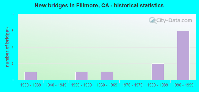
- New bridges - historical statistics
- 11930-1939
- 11950-1959
- 11960-1969
- 21980-1989
- 61990-1999


- Bridge Condition - Deck
- 66.7%Good
- 16.7%Fair
- 16.7%Poor

- Bridge Condition - Superstructure
- 66.7%Good
- 16.7%Fair
- 16.7%Poor

- Bridge Condition - Substructure
- 83.3%Good
- 16.7%Fair

- Bridge Condition - Channel
- 63.6%Excellent
- 18.2%Very good
- 9.1%Good
- 9.1%Satisfactory

- Bridge Condition - Culverts
- 60.0%Good
- 20.0%Satisfactory
- 20.0%Poor
Find on map >> Show street view
Structure Number: 52 0033, Location: 07-VEN-126-21.97-FIL (Lat: 34.399053, Lng: -118.903767), Route carried "on" structure: State highway 126, Year Built: 1981, Status: Open, Structure Length: 1.11m (3.64ft), Average Daily Traffic: 30,000 (year 2019), Truck Traffic: 14%, Average Future Daily Traffic: 46,407 (year 2041), Design Load: HS 20, Features Intersected: POLE CREEK
Minimum Vertical Clearance: 30+ m (98+ ft), Kilometerpoint: 21.970, Lanes on structure: 5, Base Highway Network: Yes (Inventory Route: 1, Subroute: 1), Owner: State Highway Agency, Approaching Roadway Width: 23.2m (76.1ft), Skew: 1 degrees, Material/Design: Concrete, Design/Construction: Slab, Number Of Spans In Main Unit: 1, Length of Maximum Span: 11.0m (36.1ft), Curb or Sidewalk Widths: Left: 1.5m (4.9ft), Right: 1.5m (4.9ft), Curb-To-Curb Width: 23.2m (76.1ft), Out-to-Out Width: 26.8m (87.9ft)
Condition: Deck: Poor, Superstructure: Poor, Substructure: Good, Channel: Excellent, Operating Rating: 93.6 metric tons, Method Used To Determine Operating Rating: Load Factor (LF), Inventory Rating: 56.4 metric tons, Method Used To Determine Inventory Rating: Load Factor (LF), Structural Evaluation: Meets minimum limits, Deck Geometry: Better than present minimum criteria, Waterway Adequacy: Superior to present desirable criteria, Approach Roadway Alignment: Superior to present desirable criteria, Length Of Structure Improvement: 1.11m (3.64ft), Designated Inspection Frequency: Every 24 months, Inspection Date: August 2021, Bridge Improvement Cost: $302,000, Roadway Improvement Cost: $60,000, Total Project Cost: $507,000 ( Estimate for 2020), Deck Structure Type: Concrete Cast-file-Place
Find on map >> Show street view
Structure Number: 52 0114, Location: 07-VEN-023-20.75 (Lat: 34.349042, Lng: -118.916578), Route carried "on" structure: State highway 23, Year Built: 1991, Status: Open, Structure Length: 0.81m (2.66ft), Average Daily Traffic: 6,200 (year 2017), Truck Traffic: 16%, Average Future Daily Traffic: 11,447 (year 2041), Design Load: HS 20, Features Intersected: GRIMES CANYON CHANNEL
Minimum Vertical Clearance: 30+ m (98+ ft), Kilometerpoint: 20.750, Lanes on structure: 2, Base Highway Network: Yes (, Subroute: 1), Owner: State Highway Agency, Approaching Roadway Width: 12.2m (40.0ft), Skew: 3 degrees, Material/Design: Concrete continuous, Design/Construction: Culvert, Number Of Spans In Main Unit: 2, Length of Maximum Span: 3.9m (12.8ft), Curb-To-Curb Width: 12.2m (40.0ft), Out-to-Out Width: 13.3m (43.6ft)
Condition: Channel: Excellent, Culverts: Good, Operating Rating: 54.1 metric tons, Method Used To Determine Operating Rating: Field evaluation and documented engineering judgment, Inventory Rating: 32.4 metric tons, Method Used To Determine Inventory Rating: Field evaluation and documented engineering judgment, Structural Evaluation: Better than present minimum criteria, Deck Geometry: Somewhat better than minimum adequacy, Waterway Adequacy: Meets minimum limits, Approach Roadway Alignment: Equal to present desirable criteria, Designated Inspection Frequency: Every 24 months, Inspection Date: July 2021
Find on map >> Show street view
Structure Number: 52 0115, Location: 07-VEN-023-20.92 (Lat: 34.351072, Lng: -118.917561), Route carried "on" structure: State highway 23, Year Built: 1991, Status: Open, Structure Length: 1.20m (3.94ft), Average Daily Traffic: 6,200 (year 2017), Truck Traffic: 16%, Average Future Daily Traffic: 11,447 (year 2041), Design Load: HS 20, Features Intersected: GRIMES CANYON CHANNEL
Minimum Vertical Clearance: 30+ m (98+ ft), Kilometerpoint: 20.920, Lanes on structure: 2, Base Highway Network: Yes (, Subroute: 1), Owner: State Highway Agency, Approaching Roadway Width: 11.6m (38.1ft), Skew: 3 degrees, Material/Design: Concrete continuous, Design/Construction: Culvert, Number Of Spans In Main Unit: 3, Length of Maximum Span: 3.9m (12.8ft), Curb-To-Curb Width: 12.8m (42.0ft), Out-to-Out Width: 13.9m (45.6ft)
Condition: Channel: Excellent, Culverts: Good, Operating Rating: 54.1 metric tons, Method Used To Determine Operating Rating: Field evaluation and documented engineering judgment, Inventory Rating: 32.4 metric tons, Method Used To Determine Inventory Rating: Field evaluation and documented engineering judgment, Structural Evaluation: Better than present minimum criteria, Deck Geometry: Somewhat better than minimum adequacy, Waterway Adequacy: Meets minimum limits, Approach Roadway Alignment: Equal to present desirable criteria, Designated Inspection Frequency: Every 24 months, Inspection Date: July 2021
Find on map >> Show street view
Structure Number: 52 0183, Location: 07-VEN-126-19.26 (Lat: 34.393469, Lng: -118.950417), Route carried "on" structure: State highway 126, Year Built: 1954, Year Reconstructed: 1991, Status: Open, Structure Length: 21.99m (72.15ft), Average Daily Traffic: 37,500 (year 2019), Truck Traffic: 11%, Average Future Daily Traffic: 48,203 (year 2041), Design Load: HS 20, Features Intersected: SESPE CREEK
Minimum Vertical Clearance: 30+ m (98+ ft), Kilometerpoint: 19.260, Lanes on structure: 4, Base Highway Network: Yes (Inventory Route: 1, Subroute: 1), Owner: State Highway Agency, Approaching Roadway Width: 23.9m (78.4ft), Skew: 2 degrees, Material/Design: Concrete continuous, Design/Construction: Tee Beam, Number Of Spans In Main Unit: 16, Length of Maximum Span: 14.3m (46.9ft), Curb-To-Curb Width: 23.9m (78.4ft), Out-to-Out Width: 24.7m (81.0ft)
Condition: Deck: Fair, Superstructure: Good, Substructure: Good, Channel: Very good, Operating Rating: 76.1 metric tons, Method Used To Determine Operating Rating: Load Factor (LF), Inventory Rating: 45.7 metric tons, Method Used To Determine Inventory Rating: Load Factor (LF), Structural Evaluation: Better than present minimum criteria, Deck Geometry: Superior to present desirable criteria, Waterway Adequacy: Equal to present desirable criteria, Approach Roadway Alignment: Superior to present desirable criteria, Designated Inspection Frequency: Every 24 months, Inspection Date: August 2021, Deck Structure Type: Concrete Cast-file-Place
Find on map >> Show street view
Structure Number: 52 0196, Location: 07-VEN-126-T16.54 (Lat: 34.378989, Lng: -118.988064), Route carried "on" structure: State highway 126, Year Built: 1966, Year Reconstructed: 1985, Status: Open, Structure Length: 0.67m (2.20ft), Average Daily Traffic: 37,500 (year 2019), Truck Traffic: 11%, Average Future Daily Traffic: 50,731 (year 2039), Design Load: HS 20, Features Intersected: O'LEARY CREEK
Minimum Vertical Clearance: 30+ m (98+ ft), Kilometerpoint: 16.540, Lanes on structure: 4, Base Highway Network: Yes (Inventory Route: 1, Subroute: 1), Owner: State Highway Agency, Approaching Roadway Width: 24.4m (80.1ft), Material/Design: Concrete continuous, Design/Construction: Culvert, Number Of Spans In Main Unit: 2, Length of Maximum Span: 3.0m (9.8ft), Curb-To-Curb Width: 24.4m (80.1ft), Out-to-Out Width: 32.9m (107.9ft)
Condition: Channel: Satisfactory, Culverts: Poor, Operating Rating: 54.1 metric tons, Method Used To Determine Operating Rating: Field evaluation and documented engineering judgment, Inventory Rating: 32.4 metric tons, Method Used To Determine Inventory Rating: Field evaluation and documented engineering judgment, Structural Evaluation: Meets minimum limits, Deck Geometry: Superior to present desirable criteria, Waterway Adequacy: Superior to present desirable criteria, Approach Roadway Alignment: Superior to present desirable criteria, Length Of Structure Improvement: 0.67m (2.20ft), Designated Inspection Frequency: Every 24 months, Inspection Date: August 2021, Bridge Improvement Cost: $221,000, Roadway Improvement Cost: $44,000, Total Project Cost: $371,000 ( Estimate for 2018)
Find on map >> Show street view
Structure Number: 52 0424, Location: 07-VEN-023-R21.02 (Lat: 34.353014, Lng: -118.918503), Route carried "on" structure: State highway 23, Year Built: 1991, Status: Open, Structure Length: 1.47m (4.82ft), Average Daily Traffic: 6,200 (year 2017), Truck Traffic: 16%, Average Future Daily Traffic: 11,447 (year 2041), Design Load: HS 20, Features Intersected: GRIMES CANYON CHANNEL
Minimum Vertical Clearance: 30+ m (98+ ft), Kilometerpoint: 21.020, Lanes on structure: 2, Base Highway Network: Yes (, Subroute: 1), Owner: State Highway Agency, Approaching Roadway Width: 14.8m (48.6ft), Skew: 4 degrees, Material/Design: Concrete continuous, Design/Construction: Culvert, Number Of Spans In Main Unit: 3, Length of Maximum Span: 4.7m (15.4ft), Curb-To-Curb Width: 14.8m (48.6ft), Out-to-Out Width: 15.8m (51.8ft)
Condition: Channel: Excellent, Culverts: Good, Operating Rating: 54.1 metric tons, Method Used To Determine Operating Rating: Field evaluation and documented engineering judgment, Inventory Rating: 32.4 metric tons, Method Used To Determine Inventory Rating: Field evaluation and documented engineering judgment, Structural Evaluation: Better than present minimum criteria, Deck Geometry: Superior to present desirable criteria, Waterway Adequacy: Meets minimum limits, Approach Roadway Alignment: Equal to present desirable criteria, Designated Inspection Frequency: Every 24 months, Inspection Date: July 2021
Find on map >> Show street view
Structure Number: 52 0425, Location: 07-VEN-023-R21.41 (Lat: 34.357842, Lng: -118.920947), Route carried "on" structure: State highway 23, Year Built: 1991, Status: Open, Structure Length: 1.76m (5.77ft), Average Daily Traffic: 7,650 (year 2015), Average Future Daily Traffic: 10,835 (year 2041), Design Load: HS 20, Features Intersected: GRIMES CANYON CHANNEL
Minimum Vertical Clearance: 30+ m (98+ ft), Kilometerpoint: 21.410, Lanes on structure: 2, Base Highway Network: Yes (, Subroute: 1), Owner: State Highway Agency, Approaching Roadway Width: 11.0m (36.1ft), Skew: 5 degrees, Material/Design: Concrete continuous, Design/Construction: Culvert, Number Of Spans In Main Unit: 3, Length of Maximum Span: 5.8m (19.0ft), Curb-To-Curb Width: 16.5m (54.1ft), Out-to-Out Width: 28.2m (92.5ft)
Condition: Channel: Excellent, Culverts: Satisfactory, Operating Rating: 54.1 metric tons, Method Used To Determine Operating Rating: Field evaluation and documented engineering judgment, Inventory Rating: 32.4 metric tons, Method Used To Determine Inventory Rating: Field evaluation and documented engineering judgment, Structural Evaluation: Equal to present minimum criteria, Deck Geometry: Superior to present desirable criteria, Waterway Adequacy: Meets minimum limits, Approach Roadway Alignment: Equal to present desirable criteria, Designated Inspection Frequency: Every 48 months, Inspection Date: July 2019
Find on map >> Show street view
Structure Number: 52 0427Y, Location: 07-VEN-023-R23.50-FIL (Lat: 34.386031, Lng: -118.915700), Route carried "on" structure: State highway 23, Year Built: 1995, Status: Open, Structure Length: 1.46m (4.79ft), Average Daily Traffic: 7,550 (year 2011), Truck Traffic: 2%, Average Future Daily Traffic: 14,402 (year 2041), Design Load: HS 20+Mod, Features Intersected: B STREET DRAINAGE CHA
Minimum Vertical Clearance: 30+ m (98+ ft), Kilometerpoint: 23.500, Lanes on structure: 2, Base Highway Network: Yes (, Subroute: 1), Owner: State Highway Agency, Approaching Roadway Width: 7.3m (24.0ft), Material/Design: Concrete continuous, Design/Construction: Slab, Number Of Spans In Main Unit: 2, Length of Maximum Span: 6.9m (22.6ft), Curb-To-Curb Width: 7.3m (24.0ft), Out-to-Out Width: 8.4m (27.6ft)
Condition: Deck: Good, Superstructure: Good, Substructure: Good, Channel: Excellent, Operating Rating: 54.1 metric tons, Method Used To Determine Operating Rating: Assigned rating based on Load Factor Design (LFD) reported in metric tons, Inventory Rating: 32.4 metric tons, Method Used To Determine Inventory Rating: Assigned rating based on Load Factor Design (LFD) reported in metric tons, Structural Evaluation: Better than present minimum criteria, Deck Geometry: High priority of replacement, Waterway Adequacy: Superior to present desirable criteria, Approach Roadway Alignment: Superior to present desirable criteria, Designated Inspection Frequency: Every 48 months, Inspection Date: July 2019, Deck Structure Type: Concrete Cast-file-Place
Find on map >> Show street view
Structure Number: 52 0436, Location: 07-VEN-023-R23.60-FIL (Lat: 34.388097, Lng: -118.916222), Route carried "on" structure: State highway 23, Year Built: 1995, Status: Open, Structure Length: 50.00m (164.04ft), Average Daily Traffic: 8,900 (year 2017), Truck Traffic: 13%, Average Future Daily Traffic: 10,763 (year 2041), Design Load: HS 20+Mod, Features Intersected: SANTA CLARA RIVER
Minimum Vertical Clearance: 30+ m (98+ ft), Kilometerpoint: 23.600, Lanes on structure: 2, Base Highway Network: Yes (, Subroute: 1), Owner: State Highway Agency, Approaching Roadway Width: 12.2m (40.0ft), Material/Design: Prestressed concrete continuous, Design/Construction: Box Beam or Girders - Multiple, Number Of Spans In Main Unit: 12, Length of Maximum Span: 43.6m (143.0ft), Curb or Sidewalk Widths: Left: 1.5m (4.9ft), Right: 0.0m, Curb-To-Curb Width: 12.2m (40.0ft), Out-to-Out Width: 14.9m (48.9ft)
Condition: Deck: Good, Superstructure: Good, Substructure: Good, Channel: Excellent, Operating Rating: 54.1 metric tons, Method Used To Determine Operating Rating: Assigned rating based on Load Factor Design (LFD) reported in metric tons, Inventory Rating: 32.4 metric tons, Method Used To Determine Inventory Rating: Assigned rating based on Load Factor Design (LFD) reported in metric tons, Structural Evaluation: Better than present minimum criteria, Deck Geometry: Somewhat better than minimum adequacy, Waterway Adequacy: Better than present minimum criteria, Approach Roadway Alignment: Better than present minimum criteria, Designated Inspection Frequency: Every 24 months, Inspection Date: July 2021, Deck Structure Type: Concrete Cast-file-Place
Find on map >> Show street view
Structure Number: 52C0012, Location: 1.0 MI N/W OF 'A' ST (Lat: 34.405542, Lng: -118.930806), Route carried "on" structure: County highway , Year Built: 1983, Status: Open, Structure Length: 14.69m (48.20ft), Average Daily Traffic: 3,700 (year 2020), Truck Traffic: 1%, Average Future Daily Traffic: 4,979 (year 2038), Design Load: HS 20+Mod, Features Intersected: EAST BRANCH SESPE CREEK, Facility Carried by Structure: OLD TELEGRAPH RD
Minimum Vertical Clearance: 30+ m (98+ ft), Kilometerpoint: 0.000, Lanes on structure: 2, Owner: County Highway Agency, Approaching Roadway Width: 12.2m (40.0ft), Material/Design: Prestressed concrete continuous, Design/Construction: Box Beam or Girders - Multiple, Number Of Spans In Main Unit: 4, Length of Maximum Span: 36.6m (120.1ft), Curb-To-Curb Width: 12.2m (40.0ft), Out-to-Out Width: 13.3m (43.6ft)
Condition: Deck: Good, Superstructure: Good, Substructure: Good, Channel: Very good, Operating Rating: 54.1 metric tons, Method Used To Determine Operating Rating: Assigned rating based on Load Factor Design (LFD) reported in metric tons, Inventory Rating: 32.4 metric tons, Method Used To Determine Inventory Rating: Assigned rating based on Load Factor Design (LFD) reported in metric tons, Structural Evaluation: Better than present minimum criteria, Deck Geometry: Equal to present minimum criteria, Waterway Adequacy: Superior to present desirable criteria, Approach Roadway Alignment: Equal to present desirable criteria, Designated Inspection Frequency: Every 24 months, Inspection Date: August 2020, Deck Structure Type: Concrete Cast-file-Place
Find on map >> Show street view
Structure Number: 52C0164, Location: 1.61 MI E OF STE RTE 126 (Lat: 34.380219, Lng: -118.988433), Route carried "on" structure: County highway , Year Built: 1932, Status: Open, Structure Length: 0.99m (3.25ft), Average Daily Traffic: 600 (year 2017), Truck Traffic: 1%, Average Future Daily Traffic: 1,034 (year 2038), Features Intersected: BOULDER CREEK, Facility Carried by Structure: SYCAMORE RD
Minimum Vertical Clearance: 30+ m (98+ ft), Kilometerpoint: 0.000, Lanes on structure: 2, Owner: County Highway Agency, Approaching Roadway Width: 6.1m (20.0ft), Skew: 3 degrees, Material/Design: Concrete, Design/Construction: Tee Beam, Number Of Spans In Main Unit: 1, Length of Maximum Span: 9.2m (30.2ft), Curb-To-Curb Width: 6.8m (22.3ft), Out-to-Out Width: 7.9m (25.9ft)
Condition: Deck: Good, Superstructure: Fair, Substructure: Fair, Channel: Good, Operating Rating: 20.1 metric tons, Method Used To Determine Operating Rating: Load and Resistance Factor Rating (LRFR) rating reported by rating factor(RF) method using HL-93 loadings, Inventory Rating: 14.3 metric tons, Method Used To Determine Inventory Rating: Load and Resistance Factor Rating (LRFR) rating reported by rating factor(RF) method using HL-93 loadings, Structural Evaluation: Meets minimum limits, Deck Geometry: Meets minimum limits, Waterway Adequacy: Somewhat better than minimum adequacy, Approach Roadway Alignment: Equal to present minimum criteria, Designated Inspection Frequency: Every 24 months, Inspection Date: August 2020, Deck Structure Type: Concrete Cast-file-Place, Wearing Surface/Protective System: Wearing Surface: Bituminous