Bridge Statistics for Ferndale, Maryland (MD)
Condition, Traffic, Stress, Structural Evaluation, Project Costs
- National Bridge Inventory (NBI) Statistics
- 17Number of bridges
- 157ft / 48.1mTotal length
- 657,567Total average daily traffic
- 46,520Total average daily truck traffic
- National Bridge Inventory (NBI) Registered Bridges for Ferndale
- No street view available for this location
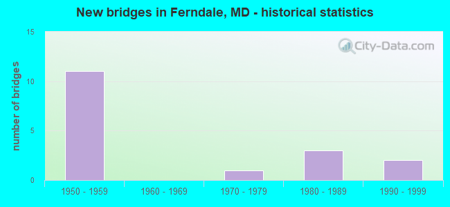
- New bridges - historical statistics
- 111950-1959
- 11970-1979
- 31980-1989
- 21990-1999

- Reconstructed bridges - Historical Statistics
- 11970-1979
- 21980-1989


- Bridge Condition - Deck
- 60.0%Good
- 40.0%Satisfactory

- Bridge Condition - Superstructure
- 20.0%Good
- 80.0%Satisfactory

- Bridge Condition - Substructure
- 20.0%Good
- 60.0%Satisfactory
- 20.0%Fair

- Bridge Condition - Channel
- 20.0%Good
- 80.0%Satisfactory
Find on map >> Show street view
Structure Number: 100000020004016, Location: 0.63 MI S OF MD 648E (Lat: 39.202336, Lng: -76.631964), Route carried "on" structure: Interstate 695, Year Built: 1957, Year Reconstructed: 1986, Status: Open, Structure Length: 7.35m (24.11ft), Average Daily Traffic: 97,630 (year 2016), Truck Traffic: 8%, Average Future Daily Traffic: 105,440 (year 2033), Design Load: HS 20, Features Intersected: IS 97
Minimum Vertical Clearance: 30+ m (98+ ft), Kilometerpoint: 0.209, Lanes on structure: 2, Lanes under structure: 6, Base Highway Network: Yes, Owner: State Highway Agency, Approaching Roadway Width: 11.9m (39.0ft), Skew: 2 degrees, Material/Design: Steel, Design/Construction: Stringer/Multi-beam, Number Of Spans In Main Unit: 4, Length of Maximum Span: 21.3m (69.9ft), Curb-To-Curb Width: 11.9m (39.0ft), Out-to-Out Width: 12.9m (42.3ft)
Condition: Deck: Good, Superstructure: Satisfactory, Substructure: Satisfactory, Operating Rating: 63.0 metric tons, Method Used To Determine Operating Rating: Load Factor (LF), Inventory Rating: 37.6 metric tons, Method Used To Determine Inventory Rating: Load Factor (LF), Structural Evaluation: Equal to present minimum criteria, Deck Geometry: Equal to present minimum criteria, Underclear: Equal to present minimum criteria, Approach Roadway Alignment: Equal to present desirable criteria, Designated Inspection Frequency: Every 24 months, Inspection Date: October 2021, Deck Structure Type: Concrete Cast-file-Place, Wearing Surface/Protective System: Wearing Surface: Monolithic Concrete, Deck Protection: Epoxy Coated Reinforcing
Find on map >> Show street view
Structure Number: 10000002005901, Location: AT IS 97 (Lat: 39.185183, Lng: -76.632044), Route carried "on" structure: County highway 242, Year Built: 1994, Status: Open, Structure Length: 8.44m (27.69ft), Average Daily Traffic: 8,400 (year 1994), Truck Traffic: 5%, Average Future Daily Traffic: 81,243 (year 2012), Design Load: HS 25 or greater, Features Intersected: IS 97, Facility Carried by Structure: WELLHAM ROAD
Minimum Vertical Clearance: 30+ m (98+ ft), Kilometerpoint: 0.708, Lanes on structure: 2, Lanes under structure: 4, Owner: State Highway Agency, Approaching Roadway Width: 11.0m (36.1ft), Material/Design: Steel continuous, Design/Construction: Stringer/Multi-beam, Number Of Spans In Main Unit: 2, Length of Maximum Span: 41.8m (137.1ft), Curb or Sidewalk Widths: Left: 0.0m, Right: 1.6m (5.2ft), Curb-To-Curb Width: 9.1m (29.9ft), Out-to-Out Width: 11.7m (38.4ft)
Condition: Deck: Good, Superstructure: Good, Substructure: Good, Operating Rating: 43.1 metric tons, Method Used To Determine Operating Rating: Load Factor (LF), Inventory Rating: 26.8 metric tons, Method Used To Determine Inventory Rating: Load Factor (LF), Structural Evaluation: Equal to present minimum criteria, Deck Geometry: Meets minimum limits, Underclear: Somewhat better than minimum adequacy, Approach Roadway Alignment: Equal to present desirable criteria, Designated Inspection Frequency: Every 24 months, Inspection Date: October 2020, Deck Structure Type: Concrete Cast-file-Place, Wearing Surface/Protective System: Wearing Surface: Integral Concrete, Deck Protection: Epoxy Coated Reinforcing
Find on map >> Show street view
Structure Number: 10000002006001, Location: 0.78 MILE NORTH OF MD 176 (Lat: 39.175806, Lng: -76.636344), Route carried "on" structure: Interstate 97, Year Built: 1955, Year Reconstructed: 1979, Status: Open, Structure Length: 7.99m (26.21ft), Average Daily Traffic: 124,594 (year 2021), Truck Traffic: 8%, Average Future Daily Traffic: 170,139 (year 2041), Design Load: HS 20, Features Intersected: MD 648E, MTA LIGHT RAIL
Minimum Vertical Clearance: 30+ m (98+ ft), Kilometerpoint: 25.068, Lanes on structure: 6, Lanes under structure: 2, Base Highway Network: Yes, Owner: State Highway Agency, Approaching Roadway Width: 43.3m (142.1ft), Skew: 22 degrees, Material/Design: Steel continuous, Design/Construction: Stringer/Multi-beam, Number Of Spans In Main Unit: 5, Length of Maximum Span: 19.2m (63.0ft), Curb-To-Curb Width: 40.2m (131.9ft), Out-to-Out Width: 41.2m (135.2ft)
Condition: Deck: Good, Superstructure: Satisfactory, Substructure: Fair, Operating Rating: 55.8 metric tons, Method Used To Determine Operating Rating: Load Factor (LF), Inventory Rating: 33.6 metric tons, Method Used To Determine Inventory Rating: Load Factor (LF), Structural Evaluation: Somewhat better than minimum adequacy, Deck Geometry: Superior to present desirable criteria, Underclear: Meets minimum limits, Approach Roadway Alignment: Equal to present desirable criteria, Designated Inspection Frequency: Every 24 months, Inspection Date: October 2020, Deck Structure Type: Concrete Cast-file-Place, Wearing Surface/Protective System: Wearing Surface: Monolithic Concrete
Find on map >> Show street view
Structure Number: 10000002006403, Location: 0.06 MILE NORTH OF MD 270 (Lat: 39.183133, Lng: -76.614419), Route carried "on" structure: Business State highway 3, Year Built: 1980, Status: Open, Structure Length: 1.66m (5.45ft), Average Daily Traffic: 17,610 (year 2009), Truck Traffic: 8%, Average Future Daily Traffic: 26,415 (year 2029), Design Load: HS 20, Features Intersected: SAWMILL CREEK
Minimum Vertical Clearance: 30+ m (98+ ft), Kilometerpoint: 7.611, Lanes on structure: 2, Owner: State Highway Agency, Approaching Roadway Width: 9.1m (29.9ft), Material/Design: Steel, Design/Construction: Culvert, Length of Maximum Span: 2.1m (6.9ft)
Condition: Channel: Satisfactory, Culverts: Satisfactory, Operating Rating: 56.7 metric tons, Method Used To Determine Operating Rating: Load Factor (LF), Inventory Rating: 34.0 metric tons, Method Used To Determine Inventory Rating: Load Factor (LF), Structural Evaluation: Equal to present minimum criteria, Waterway Adequacy: Better than present minimum criteria, Approach Roadway Alignment: Equal to present desirable criteria, Designated Inspection Frequency: Every 24 months, Inspection Date: April 2021
Find on map >> Show street view
Structure Number: 10000002011902, Location: 0.42 MILE WEST OF MD 2 (Lat: 39.202817, Lng: -76.621708), Route carried "on" structure: County highway 297, Year Built: 1957, Status: Open, Structure Length: 1.61m (5.28ft), Average Daily Traffic: 2,000 (year 1994), Truck Traffic: 5%, Average Future Daily Traffic: 2,360 (year 2012), Design Load: HS 20, Features Intersected: CABIN BRANCH, Facility Carried by Structure: CEDAR AVENUE
Minimum Vertical Clearance: 30+ m (98+ ft), Kilometerpoint: 1.319, Lanes on structure: 2, Owner: State Highway Agency, Approaching Roadway Width: 10.4m (34.1ft), Skew: 3 degrees, Material/Design: Concrete, Design/Construction: Culvert, Length of Maximum Span: 7.6m (24.9ft)
Condition: Channel: Satisfactory, Culverts: Satisfactory, Operating Rating: 32.7 metric tons, Method Used To Determine Operating Rating: Field evaluation and documented engineering judgment, Inventory Rating: 32.7 metric tons, Method Used To Determine Inventory Rating: Field evaluation and documented engineering judgment, Structural Evaluation: Equal to present minimum criteria, Waterway Adequacy: Equal to present desirable criteria, Approach Roadway Alignment: Equal to present desirable criteria, Designated Inspection Frequency: Every 24 months, Inspection Date: Febuary 2021
Find on map >> Show street view
Structure Number: 10000002012002, Location: 0.40 MI S OF MD 695 (Lat: 39.202442, Lng: -76.616903), Route carried "on" structure: Interstate 895B, Year Built: 1957, Status: Open, Structure Length: 1.52m (4.99ft), Average Daily Traffic: 21,141 (year 2009), Truck Traffic: 8%, Average Future Daily Traffic: 5,639 (year 2026), Design Load: HS 20, Features Intersected: CABIN BRANCH
Minimum Vertical Clearance: 30+ m (98+ ft), Kilometerpoint: 0.676, Lanes on structure: 4, Base Highway Network: Yes, Toll: On toll road, Owner: State Highway Agency, Approaching Roadway Width: 37.8m (124.0ft), Skew: 3 degrees, Material/Design: Concrete, Design/Construction: Culvert, Number Of Spans In Main Unit: 2, Length of Maximum Span: 7.3m (24.0ft)
Condition: Channel: Satisfactory, Culverts: Satisfactory, Operating Rating: 32.7 metric tons, Method Used To Determine Operating Rating: Field evaluation and documented engineering judgment, Inventory Rating: 32.7 metric tons, Method Used To Determine Inventory Rating: Field evaluation and documented engineering judgment, Structural Evaluation: Equal to present minimum criteria, Waterway Adequacy: Equal to present desirable criteria, Approach Roadway Alignment: Equal to present desirable criteria, Designated Inspection Frequency: Every 24 months, Inspection Date: Febuary 2021
Find on map >> Show street view
Structure Number: 10000002012101, Location: 0.5 MI N OF MD 2 (Lat: 39.204989, Lng: -76.622825), Route carried "on" structure: State highway 695, Year Built: 1957, Year Reconstructed: 1989, Status: Open, Structure Length: 7.92m (25.98ft), Average Daily Traffic: 92,102 (year 2009), Truck Traffic: 8%, Average Future Daily Traffic: 107,128 (year 2026), Design Load: HS 20+Mod, Features Intersected: IS 895B
Minimum Vertical Clearance: 30+ m (98+ ft), Kilometerpoint: 3.492, Lanes on structure: 7, Lanes under structure: 5, Base Highway Network: Yes, Owner: State Highway Agency, Approaching Roadway Width: 42.4m (139.1ft), Skew: 21 degrees, Material/Design: Steel, Design/Construction: Stringer/Multi-beam, Number Of Spans In Main Unit: 4, Length of Maximum Span: 23.8m (78.1ft), Curb-To-Curb Width: 40.7m (133.5ft), Out-to-Out Width: 41.7m (136.8ft)
Condition: Deck: Satisfactory, Superstructure: Satisfactory, Substructure: Satisfactory, Inventory Rating: 54.9 metric tons, Method Used To Determine Inventory Rating: Load Factor (LF), Structural Evaluation: Equal to present minimum criteria, Deck Geometry: Superior to present desirable criteria, Underclear: Meets minimum limits, Approach Roadway Alignment: Equal to present desirable criteria, Designated Inspection Frequency: Every 24 months, Inspection Date: July 2021, Deck Structure Type: Concrete Cast-file-Place, Wearing Surface/Protective System: Wearing Surface: Monolithic Concrete, Deck Protection: Epoxy Coated Reinforcing
Find on map >> Show street view
Structure Number: 10000002013601, Location: 0.28 MI S OF IS 895 (Lat: 39.201122, Lng: -76.631981), Route carried "on" structure: Ramp Interstate 97, Year Built: 1989, Status: Open, Structure Length: 9.66m (31.69ft), Average Daily Traffic: 84,179 (year 2006), Truck Traffic: 8%, Average Future Daily Traffic: 90,913 (year 2026), Design Load: HS 20+Mod, Features Intersected: IS 97
Minimum Vertical Clearance: 30+ m (98+ ft), Kilometerpoint: 0.483, Lanes on structure: 3, Lanes under structure: 6, Base Highway Network: Yes, Owner: State Highway Agency, Approaching Roadway Width: 17.1m (56.1ft), Skew: 5 degrees, Material/Design: Steel continuous, Design/Construction: Stringer/Multi-beam, Number Of Spans In Main Unit: 2, Length of Maximum Span: 54.3m (178.1ft), Curb-To-Curb Width: 17.1m (56.1ft), Out-to-Out Width: 18.0m (59.1ft)
Condition: Deck: Satisfactory, Superstructure: Satisfactory, Substructure: Satisfactory, Operating Rating: 89.8 metric tons, Method Used To Determine Operating Rating: Load Factor (LF), Inventory Rating: 53.5 metric tons, Method Used To Determine Inventory Rating: Load Factor (LF), Structural Evaluation: Equal to present minimum criteria, Deck Geometry: Superior to present desirable criteria, Underclear: Equal to present minimum criteria, Approach Roadway Alignment: Equal to present desirable criteria, Designated Inspection Frequency: Every 24 months, Inspection Date: October 2021, Deck Structure Type: Concrete Cast-file-Place, Wearing Surface/Protective System: Wearing Surface: Monolithic Concrete, Deck Protection: Epoxy Coated Reinforcing
Find on map >> Show street view
Structure Number: 10000002020803, Location: 0.19 MILE SOUTH OF MD 170 (Lat: 39.194597, Lng: -76.655422), Route carried "on" structure: State highway 762, Year Built: 1970, Status: Open, Structure Length: 0.79m (2.59ft), Average Daily Traffic: 8,631 (year 2009), Truck Traffic: 8%, Average Future Daily Traffic: 11,727 (year 2026), Features Intersected: CABIN BRANCH
Minimum Vertical Clearance: 30+ m (98+ ft), Kilometerpoint: 0.547, Lanes on structure: 4, Owner: State Highway Agency, Approaching Roadway Width: 26.2m (86.0ft), Skew: 20 degrees, Material/Design: Steel, Design/Construction: Culvert, Length of Maximum Span: 3.7m (12.1ft)
Condition: Channel: Good, Culverts: Satisfactory, Operating Rating: 38.1 metric tons, Method Used To Determine Operating Rating: Field evaluation and documented engineering judgment, Inventory Rating: 38.1 metric tons, Method Used To Determine Inventory Rating: Field evaluation and documented engineering judgment, Structural Evaluation: Equal to present minimum criteria, Waterway Adequacy: Equal to present desirable criteria, Approach Roadway Alignment: Equal to present desirable criteria, Designated Inspection Frequency: Every 24 months, Inspection Date: April 2021
Find on map >> Show street view
Structure Number: 200000AA501303, Location: CROMWELL BUSINESS PARK (Lat: 39.174967, Lng: -76.640833), Route carried "on" structure: County highway 162A, Year Built: 1996, Status: Open, Structure Length: 1.16m (3.81ft), Average Daily Traffic: 3,706 (year 2016), Truck Traffic: 5%, Average Future Daily Traffic: 6,800 (year 2030), Design Load: HS 25 or greater, Features Intersected: MUDDY BRIDGE BRANCH, Facility Carried by Structure: CROMWELL PARK DR
Minimum Vertical Clearance: 30+ m (98+ ft), Kilometerpoint: 0.032, Lanes on structure: 2, Owner: County Highway Agency, Approaching Roadway Width: 15.2m (49.9ft), Skew: 1 degrees, Material/Design: Steel, Design/Construction: Culvert, Number Of Spans In Main Unit: 3, Length of Maximum Span: 4.9m (16.1ft), Curb or Sidewalk Widths: Left: 0.3m (1.0ft), Right: 0.3m (1.0ft)
Condition: Channel: Satisfactory, Culverts: Satisfactory, Structural Evaluation: Equal to present minimum criteria, Waterway Adequacy: Better than present minimum criteria, Approach Roadway Alignment: Equal to present desirable criteria, Designated Inspection Frequency: Every 24 months, Inspection Date: December 2021
Find on map >> Show street view
Structure Number: 100000020004015, Location: 0.16 MI S OF IS 895A (Lat: 39.202778, Lng: -76.631053), Route carried "under" structure: Interstate 97, Year Built: 1957, Structure Length: 0. m, Average Daily Traffic: 18,621 (year 2009), Features Intersected: IS 97, Facility Carried by Structure: IS 695 IL
Minimum Vertical Clearance: 5.18m (16.99ft), Kilometerpoint: 28.093, Lanes on structure: 3, Lanes under structure: 4, Material/Design: Steel, Design/Construction: Stringer/Multi-beam, Length of Maximum Span: 22.3m (73.2ft)
Find on map >> Show street view
Structure Number: 100000020004016, Location: 0.16 MI S OF IS 895A (Lat: 39.202392, Lng: -76.631900), Route carried "under" structure: Interstate 97, Year Built: 1957, Structure Length: 0. m, Average Daily Traffic: 18,621 (year 2009), Features Intersected: IS 97, Facility Carried by Structure: IS 695 OL
Minimum Vertical Clearance: 6.10m (20.01ft), Kilometerpoint: 28.093, Lanes on structure: 2, Lanes under structure: 6, Material/Design: Steel, Design/Construction: Stringer/Multi-beam, Length of Maximum Span: 21.3m (69.9ft)
Find on map >> Show street view
Structure Number: 10000002005801, Location: 0.59 MILE EAST OF MD 648 (Lat: 39.197008, Lng: -76.632025), Route carried "under" structure: County highway 273, Year Built: 1955, Structure Length: 0. m, Average Daily Traffic: 16,600 (year 2007), Features Intersected: FURNACE BRANCH ROAD, Facility Carried by Structure: IS 97
Minimum Vertical Clearance: 5.18m (16.99ft), Kilometerpoint: 0.949, Lanes on structure: 6, Lanes under structure: 2, Material/Design: Steel, Design/Construction: Stringer/Multi-beam, Length of Maximum Span: 18.9m (62.0ft)
Find on map >> Show street view
Structure Number: 10000002005901, Location: 1.21 M S OD IS 695 (Lat: 39.185183, Lng: -76.632044), Route carried "under" structure: Interstate 97, Year Built: 1955, Structure Length: 0. m, Average Daily Traffic: 103,350 (year 2009), Truck Traffic: 8%, Features Intersected: IS 97, Facility Carried by Structure: WELLHAM ROAD
Minimum Vertical Clearance: 4.88m (16.01ft), Kilometerpoint: 26.146, Lanes on structure: 2, Lanes under structure: 4, Material/Design: Steel continuous, Design/Construction: Stringer/Multi-beam, Length of Maximum Span: 18.3m (60.0ft)
Find on map >> Show street view
Structure Number: 10000002006001, Location: 0.48 MI N OF MD 176 (Lat: 39.175825, Lng: -76.636403), Route carried "under" structure: State highway 648E, Year Built: 1955, Structure Length: 0. m, Average Daily Traffic: 16,880 (year 2009), Features Intersected: MD 648E, MTA LIGHT RAIL, Facility Carried by Structure: IS 97
Minimum Vertical Clearance: 5.49m (18.01ft), Kilometerpoint: 6.903, Lanes on structure: 6, Lanes under structure: 2, Material/Design: Steel continuous, Design/Construction: Stringer/Multi-beam, Length of Maximum Span: 19.2m (63.0ft)
Find on map >> Show street view
Structure Number: 10000002012101, Location: 0.55 MILE NORTH OF MD 2 (Lat: 39.204989, Lng: -76.622825), Route carried "under" structure: Interstate 895B, Year Built: 1957, Structure Length: 0. m, Average Daily Traffic: 4,881 (year 2009), Truck Traffic: 8%, Features Intersected: IS 895B, Facility Carried by Structure: MD 695
Minimum Vertical Clearance: 4.57m (14.99ft), Kilometerpoint: 1.287, Lanes on structure: 7, Lanes under structure: 5, Material/Design: Steel, Design/Construction: Stringer/Multi-beam, Length of Maximum Span: 23.8m (78.1ft)
Find on map >> Show street view
Structure Number: 10000002013601, Location: 0.28 MILE SOUTH OF IS 895 (Lat: 39.200581, Lng: -76.631475), Route carried "under" structure: Interstate 97, Year Built: 1989, Structure Length: 0. m, Average Daily Traffic: 18,621 (year 2009), Truck Traffic: 8%, Features Intersected: IS 97
Minimum Vertical Clearance: 5.18m (16.99ft), Kilometerpoint: 27.916, Lanes on structure: 3, Lanes under structure: 6, Material/Design: Steel continuous, Design/Construction: Stringer/Multi-beam, Length of Maximum Span: 54.3m (178.1ft)