Bridge Statistics for Fairland, Maryland (MD)
Condition, Traffic, Stress, Structural Evaluation, Project Costs
- National Bridge Inventory (NBI) Statistics
- 14Number of bridges
- 269ft / 81.6mTotal length
- $106,000Total costs
- 258,693Total average daily traffic
- 5,997Total average daily truck traffic
- National Bridge Inventory (NBI) Registered Bridges for Fairland
- No street view available for this location
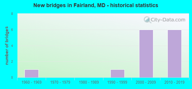
- New bridges - historical statistics
- 11960-1969
- 11990-1999
- 62000-2009
- 62010-2019


- Bridge Condition - Deck
- 10.0%Very good
- 60.0%Good
- 20.0%Satisfactory
- 10.0%Fair

- Bridge Condition - Superstructure
- 20.0%Very good
- 60.0%Good
- 20.0%Satisfactory

- Bridge Condition - Substructure
- 40.0%Very good
- 50.0%Good
- 10.0%Fair

- Bridge Condition - Channel
- 50.0%Satisfactory
- 50.0%Fair
Find on map >> Show street view
Structure Number: 10000015018001, Location: 0.17 MILE EAST OF MD 929C (Lat: 39.062664, Lng: -76.963169), Route carried "on" structure: State highway 929A, Year Built: 2006, Status: Open, Structure Length: 5.21m (17.09ft), Average Daily Traffic: 36,072 (year 2009), Truck Traffic: 3%, Average Future Daily Traffic: 76,216 (year 2026), Design Load: HS 25 or greater, Features Intersected: US 29
Minimum Vertical Clearance: 30+ m (98+ ft), Kilometerpoint: 4.023, Lanes on structure: 8, Lanes under structure: 6, Base Highway Network: Yes, Owner: State Highway Agency, Approaching Roadway Width: 37.8m (124.0ft), Skew: 1 degrees, Material/Design: Steel continuous, Design/Construction: Stringer/Multi-beam, Number Of Spans In Main Unit: 2, Length of Maximum Span: 25.3m (83.0ft), Curb or Sidewalk Widths: Left: 3.4m (11.2ft), Right: 2.4m (7.9ft), Curb-To-Curb Width: 36.1m (118.4ft), Out-to-Out Width: 42.8m (140.4ft)
Condition: Deck: Good, Superstructure: Very good, Substructure: Very good, Operating Rating: 83.0 metric tons, Method Used To Determine Operating Rating: Load Factor (LF), Inventory Rating: 49.4 metric tons, Method Used To Determine Inventory Rating: Load Factor (LF), Structural Evaluation: Equal to present desirable criteria, Deck Geometry: Superior to present desirable criteria, Underclear: Equal to present minimum criteria, Approach Roadway Alignment: Equal to present desirable criteria, Designated Inspection Frequency: Every 24 months, Inspection Date: September 2021, Deck Structure Type: Concrete Cast-file-Place, Wearing Surface/Protective System: Wearing Surface: Integral Concrete, Deck Protection: Epoxy Coated Reinforcing
Find on map >> Show street view
Structure Number: 10000015018104, Location: 0.033 MILE WEST OF US 29 (Lat: 39.062744, Lng: -76.963467), Route carried "on" structure: State highway 929A, Year Built: 2006, Status: Open, Structure Length: 0.88m (2.89ft), Average Daily Traffic: 36,072 (year 2009), Truck Traffic: 3%, Average Future Daily Traffic: 38,639 (year 2026), Design Load: HS 25 or greater, Features Intersected: US 29 FUTURE RAMP E
Minimum Vertical Clearance: 30+ m (98+ ft), Kilometerpoint: 3.969, Lanes on structure: 7, Lanes under structure: 1, Base Highway Network: Yes, Owner: State Highway Agency, Approaching Roadway Width: 37.8m (124.0ft), Skew: 31 degrees, Material/Design: Concrete, Design/Construction: Frame, Number Of Spans In Main Unit: 1, Length of Maximum Span: 6.7m (22.0ft), Curb or Sidewalk Widths: Left: 5.1m (16.7ft), Right: 3.8m (12.5ft), Curb-To-Curb Width: 28.1m (92.2ft), Out-to-Out Width: 41.1m (134.8ft)
Condition: Deck: Satisfactory, Superstructure: Satisfactory, Substructure: Good, Structural Evaluation: Equal to present minimum criteria, Deck Geometry: Somewhat better than minimum adequacy, Underclear: Meets minimum limits, Approach Roadway Alignment: Equal to present desirable criteria, Designated Inspection Frequency: Every 24 months, Inspection Date: May 2020, Deck Structure Type: Concrete Cast-file-Place, Wearing Surface/Protective System: Wearing Surface: Latex Concrete, Deck Protection: Epoxy Coated Reinforcing
Find on map >> Show street view
Structure Number: 10000015018601, Location: AT US 29 (Lat: 39.083153, Lng: -76.948667), Route carried "on" structure: County highway 95, Year Built: 2007, Status: Open, Structure Length: 5.58m (18.31ft), Average Daily Traffic: 11,212 (year 2006), Average Future Daily Traffic: 12,927 (year 2026), Design Load: HS 25 or greater, Features Intersected: US 29, Facility Carried by Structure: BRIGGS CHANEY ROAD
Minimum Vertical Clearance: 30+ m (98+ ft), Kilometerpoint: 0.000, Lanes on structure: 6, Lanes under structure: 8, Owner: State Highway Agency, Approaching Roadway Width: 23.8m (78.1ft), Skew: 20 degrees, Material/Design: Steel continuous, Design/Construction: Stringer/Multi-beam, Number Of Spans In Main Unit: 2, Length of Maximum Span: 30.5m (100.1ft), Curb or Sidewalk Widths: Left: 1.6m (5.2ft), Right: 3.0m (9.8ft), Curb-To-Curb Width: 23.8m (78.1ft), Out-to-Out Width: 34.7m (113.8ft)
Condition: Deck: Good, Superstructure: Good, Substructure: Very good, Inventory Rating: 57.1 metric tons, Method Used To Determine Inventory Rating: Load Factor (LF), Structural Evaluation: Better than present minimum criteria, Deck Geometry: Somewhat better than minimum adequacy, Underclear: Meets minimum limits, Approach Roadway Alignment: Equal to present desirable criteria, Designated Inspection Frequency: Every 24 months, Inspection Date: September 2021, Deck Structure Type: Concrete Cast-file-Place, Wearing Surface/Protective System: Wearing Surface: Integral Concrete, Deck Protection: Epoxy Coated Reinforcing
Find on map >> Show street view
Structure Number: 200000M-009101, Location: 1.5 MI WEST OF US 29 (Lat: 39.077522, Lng: -76.976503), Route carried "on" structure: County highway 98, Year Built: 1965, Status: Posted for load, Structure Length: 3.78m (12.40ft), Average Daily Traffic: 16,000 (year 2011), Truck Traffic: 5%, Average Future Daily Traffic: 17,700 (year 2031), Design Load: H 20, Features Intersected: PAINT BRANCH, Facility Carried by Structure: FAIRLAND ROAD
Minimum Vertical Clearance: 30+ m (98+ ft), Kilometerpoint: 1.657, Lanes on structure: 2, Owner: County Highway Agency, Approaching Roadway Width: 13.4m (44.0ft), Skew: 4 degrees, Material/Design: Steel, Design/Construction: Stringer/Multi-beam, Number Of Spans In Main Unit: 2, Length of Maximum Span: 17.7m (58.1ft), Curb or Sidewalk Widths: Left: 1.5m (4.9ft), Right: 0.5m (1.6ft), Curb-To-Curb Width: 9.1m (29.9ft), Out-to-Out Width: 11.7m (38.4ft)
Condition: Deck: Fair, Superstructure: Satisfactory, Substructure: Fair, Channel: Satisfactory, Operating Rating: 52.6 metric tons, Method Used To Determine Operating Rating: Load Factor (LF), Inventory Rating: 31.7 metric tons, Method Used To Determine Inventory Rating: Load Factor (LF), Structural Evaluation: Somewhat better than minimum adequacy, Deck Geometry: High priority of corrective action, Waterway Adequacy: Better than present minimum criteria, Approach Roadway Alignment: Equal to present desirable criteria, Length Of Structure Improvement: 3.78m (12.40ft), Designated Inspection Frequency: Every 24 months, Inspection Date: June 2020, Bridge Improvement Cost: $12,000, Roadway Improvement Cost: $18,000, Total Project Cost: $30,000, Deck Structure Type: Concrete Cast-file-Place, Wearing Surface/Protective System: Wearing Surface: Bituminous
Find on map >> Show street view
Structure Number: 200000M-009502, Location: 1 MI EAST OF US 29 (Lat: 39.066911, Lng: -76.937408), Route carried "on" structure: County highway 95, Year Built: 1994, Status: Open, Structure Length: 1.26m (4.13ft), Average Daily Traffic: 12,100 (year 2017), Truck Traffic: 5%, Average Future Daily Traffic: 13,500 (year 2037), Design Load: HS 20, Features Intersected: LITTLE PAINT BRANCH TRIB, Facility Carried by Structure: BRIGGS CHANEY ROAD
Minimum Vertical Clearance: 30+ m (98+ ft), Kilometerpoint: 0.000, Lanes on structure: 2, Owner: County Highway Agency, Approaching Roadway Width: 13.7m (44.9ft), Material/Design: Concrete, Design/Construction: Culvert, Length of Maximum Span: 2.7m (8.9ft)
Condition: Channel: Fair, Culverts: Satisfactory, Structural Evaluation: Equal to present minimum criteria, Waterway Adequacy: Better than present minimum criteria, Approach Roadway Alignment: Better than present minimum criteria, Length Of Structure Improvement: 1.28m (4.20ft), Designated Inspection Frequency: Every 24 months, Inspection Date: September 2020, Bridge Improvement Cost: $76,000, Total Project Cost: $76,000 ( Estimate for 2015)
Find on map >> Show street view
Structure Number: 300000M-V15701, Location: 0.18 Mi. West of US (Lat: 39.078950, Lng: -76.958100), Route carried "on" structure: Bypass State highway 200, Year Built: 2010, Status: Open, Structure Length: 11.67m (38.29ft), Average Daily Traffic: 9,633 (year 2019), Truck Traffic: 4%, Average Future Daily Traffic: 11,990 (year 2041), Design Load: HS 25 or greater, Features Intersected: MD-200 & Ramps SW & EN, Facility Carried by Structure: Old Columbia Pike
Minimum Vertical Clearance: 30+ m (98+ ft), Kilometerpoint: 0.254, Lanes on structure: 1, Lanes under structure: 1, Owner: State Toll Authority, Approaching Roadway Width: 9.8m (32.2ft), Material/Design: Steel continuous, Design/Construction: Stringer/Multi-beam, Number Of Spans In Main Unit: 4, Length of Maximum Span: 30.5m (100.1ft), Curb or Sidewalk Widths: Left: 1.7m (5.6ft), Right: 1.7m (5.6ft), Curb-To-Curb Width: 9.8m (32.2ft), Out-to-Out Width: 14.3m (46.9ft)
Condition: Deck: Good, Superstructure: Good, Substructure: Good, Operating Rating: 59.9 metric tons, Method Used To Determine Operating Rating: Load Factor (LF), Inventory Rating: 35.8 metric tons, Method Used To Determine Inventory Rating: Load Factor (LF), Structural Evaluation: Better than present minimum criteria, Deck Geometry: Meets minimum limits, Underclear: Superior to present desirable criteria, Approach Roadway Alignment: Equal to present desirable criteria, Designated Inspection Frequency: Every 24 months, Inspection Date: September 2021, Deck Structure Type: Concrete Cast-file-Place, Wearing Surface/Protective System: Wearing Surface: Integral Concrete, Deck Protection: Epoxy Coated Reinforcing
Find on map >> Show street view
Structure Number: 300000M-V15801, Location: 0.2 miles west of US (Lat: 39.078431, Lng: -76.955061), Route carried "on" structure: Ramp State highway 200, Year Built: 2010, Status: Open, Structure Length: 1.83m (6.00ft), Average Daily Traffic: 2,449 (year 2019), Truck Traffic: 1%, Average Future Daily Traffic: 4,793 (year 2041), Design Load: HS 25 or greater, Features Intersected: MD 200 (ICC) Ramp SE
Minimum Vertical Clearance: 30+ m (98+ ft), Kilometerpoint: 0.256, Lanes on structure: 1, Lanes under structure: 1, Toll: On toll road, Owner: State Toll Authority, Approaching Roadway Width: 9.4m (30.8ft), Material/Design: Prestressed concrete, Design/Construction: Stringer/Multi-beam, Number Of Spans In Main Unit: 1, Length of Maximum Span: 16.8m (55.1ft), Curb-To-Curb Width: 9.7m (31.8ft), Out-to-Out Width: 10.9m (35.8ft)
Condition: Deck: Good, Superstructure: Good, Substructure: Very good, Operating Rating: 83.9 metric tons, Method Used To Determine Operating Rating: Load Factor (LF), Inventory Rating: 50.3 metric tons, Method Used To Determine Inventory Rating: Load Factor (LF), Structural Evaluation: Better than present minimum criteria, Deck Geometry: Superior to present desirable criteria, Underclear: Equal to present desirable criteria, Approach Roadway Alignment: Equal to present desirable criteria, Designated Inspection Frequency: Every 24 months, Inspection Date: August 2021, Deck Structure Type: Concrete Cast-file-Place, Wearing Surface/Protective System: Wearing Surface: Integral Concrete, Deck Protection: Epoxy Coated Reinforcing
Find on map >> Show street view
Structure Number: 300000M-V15901, Location: 0.12 Miles west of U (Lat: 39.077211, Lng: -76.954781), Route carried "on" structure: Ramp State highway 200, Year Built: 2011, Status: Open, Structure Length: 2.32m (7.61ft), Average Daily Traffic: 2,449 (year 2019), Truck Traffic: 1%, Average Future Daily Traffic: 4,793 (year 2041), Design Load: HS 25 or greater, Features Intersected: Ramp SE, Facility Carried by Structure: Ramp ES
Minimum Vertical Clearance: 30+ m (98+ ft), Kilometerpoint: 0.257, Lanes on structure: 4, Lanes under structure: 10, Toll: On toll road, Owner: State Toll Authority, Approaching Roadway Width: 8.2m (26.9ft), Material/Design: Prestressed concrete, Design/Construction: Stringer/Multi-beam, Number Of Spans In Main Unit: 1, Length of Maximum Span: 21.3m (69.9ft), Curb-To-Curb Width: 8.2m (26.9ft), Out-to-Out Width: 9.4m (30.8ft)
Condition: Deck: Very good, Superstructure: Good, Substructure: Very good, Inventory Rating: 58.5 metric tons, Method Used To Determine Inventory Rating: Load Factor (LF), Structural Evaluation: Better than present minimum criteria, Deck Geometry: High priority of replacement, Underclear: Equal to present desirable criteria, Approach Roadway Alignment: Equal to present desirable criteria, Designated Inspection Frequency: Every 24 months, Inspection Date: August 2021, Deck Structure Type: Concrete Precast Panels, Wearing Surface/Protective System: Wearing Surface: Integral Concrete, Deck Protection: Epoxy Coated Reinforcing
Find on map >> Show street view
Structure Number: 300000M-V16201, Location: 0.10 Mi. West of US (Lat: 39.076461, Lng: -76.954900), Route carried "on" structure: Ramp State highway 200, Year Built: 2010, Status: Open, Structure Length: 3.23m (10.60ft), Average Daily Traffic: 2,449 (year 2019), Truck Traffic: 1%, Average Future Daily Traffic: 4,793 (year 2041), Design Load: HS 25 or greater, Features Intersected: MD 200 (ICC) Ramp SB
Minimum Vertical Clearance: 30+ m (98+ ft), Kilometerpoint: 0.262, Lanes on structure: 2, Lanes under structure: 15, Toll: On toll road, Owner: State Toll Authority, Approaching Roadway Width: 8.2m (26.9ft), Skew: 4 degrees, Material/Design: Prestressed concrete, Design/Construction: Stringer/Multi-beam, Number Of Spans In Main Unit: 1, Length of Maximum Span: 29.3m (96.1ft), Curb-To-Curb Width: 8.2m (26.9ft), Out-to-Out Width: 9.4m (30.8ft)
Condition: Deck: Good, Superstructure: Good, Substructure: Good, Inventory Rating: 59.9 metric tons, Method Used To Determine Inventory Rating: Load Factor (LF), Structural Evaluation: Better than present minimum criteria, Deck Geometry: High priority of corrective action, Underclear: High priority of corrective action, Approach Roadway Alignment: Equal to present desirable criteria, Designated Inspection Frequency: Every 24 months, Inspection Date: September 2021, Deck Structure Type: Concrete Cast-file-Place, Wearing Surface/Protective System: Wearing Surface: Integral Concrete, Deck Protection: Epoxy Coated Reinforcing
Find on map >> Show street view
Structure Number: 300000M-V16301, Location: 1.0 Mi. East of Old (Lat: 39.077878, Lng: -76.951433), Route carried "on" structure: State highway 200, Year Built: 2011, Status: Open, Structure Length: 37.37m (122.60ft), Average Daily Traffic: 2,397 (year 2019), Truck Traffic: 2%, Average Future Daily Traffic: 4,692 (year 2041), Design Load: HS 25 or greater, Features Intersected: MD 200 (ICC)/US29, Rp EB, Facility Carried by Structure: RAMP WS
Minimum Vertical Clearance: 30+ m (98+ ft), Kilometerpoint: 0.257, Lanes on structure: 1, Lanes under structure: 16, Toll: On toll road, Owner: State Toll Authority, Approaching Roadway Width: 12.2m (40.0ft), Material/Design: Steel continuous, Design/Construction: Stringer/Multi-beam, Number Of Spans In Main Unit: 5, Length of Maximum Span: 80.8m (265.1ft), Curb-To-Curb Width: 12.2m (40.0ft), Out-to-Out Width: 13.4m (44.0ft)
Condition: Deck: Good, Superstructure: Very good, Substructure: Good, Operating Rating: 73.5 metric tons, Method Used To Determine Operating Rating: Load Factor (LF), Inventory Rating: 44.0 metric tons, Method Used To Determine Inventory Rating: Load Factor (LF), Structural Evaluation: Better than present minimum criteria, Deck Geometry: Equal to present minimum criteria, Underclear: High priority of corrective action, Approach Roadway Alignment: Equal to present desirable criteria, Designated Inspection Frequency: Every 24 months, Inspection Date: September 2021, Deck Structure Type: Concrete Cast-file-Place, Wearing Surface/Protective System: Wearing Surface: Integral Concrete, Deck Protection: Epoxy Coated Reinforcing
Find on map >> Show street view
Structure Number: 300000M-V16801, Location: 0.75 MI E OF US 29 (Lat: 39.073481, Lng: -76.939239), Route carried "on" structure: Bypass State highway 200, Year Built: 2011, Status: Open, Structure Length: 8.44m (27.69ft), Average Daily Traffic: 18,193 (year 2019), Truck Traffic: 1%, Average Future Daily Traffic: 22,157 (year 2041), Design Load: HS 25 or greater, Features Intersected: MD 200 (ICC), Facility Carried by Structure: Briggs Chaney Road
Minimum Vertical Clearance: 30+ m (98+ ft), Kilometerpoint: 27.031, Lanes on structure: 5, Lanes under structure: 7, Owner: State Toll Authority, Approaching Roadway Width: 21.3m (69.9ft), Skew: 23 degrees, Material/Design: Steel continuous, Design/Construction: Stringer/Multi-beam, Number Of Spans In Main Unit: 2, Length of Maximum Span: 43.0m (141.1ft), Curb or Sidewalk Widths: Left: 3.0m (9.8ft), Right: 1.7m (5.6ft), Curb-To-Curb Width: 21.3m (69.9ft), Out-to-Out Width: 27.2m (89.2ft)
Condition: Deck: Satisfactory, Superstructure: Good, Substructure: Good, Operating Rating: 90.2 metric tons, Method Used To Determine Operating Rating: Load Factor (LF), Inventory Rating: 54.0 metric tons, Method Used To Determine Inventory Rating: Load Factor (LF), Structural Evaluation: Better than present minimum criteria, Deck Geometry: Meets minimum limits, Underclear: Superior to present desirable criteria, Approach Roadway Alignment: Equal to present desirable criteria, Designated Inspection Frequency: Every 24 months, Inspection Date: September 2021, Deck Structure Type: Concrete Cast-file-Place, Wearing Surface/Protective System: Wearing Surface: Integral Concrete, Deck Protection: Epoxy Coated Reinforcing
Find on map >> Show street view
Structure Number: 10000015018001, Location: 0.47 M N OF TECH ROAD (Lat: 39.062664, Lng: -76.963169), Route carried "under" structure: US 29, Year Built: 2006, Structure Length: 0. m, Average Daily Traffic: 54,750 (year 2006), Truck Traffic: 3%, Features Intersected: US 29
Minimum Vertical Clearance: 4.88m (16.01ft), Kilometerpoint: 11.022, Lanes on structure: 8, Lanes under structure: 6, Material/Design: Steel continuous, Design/Construction: Stringer/Multi-beam, Length of Maximum Span: 25.3m (83.0ft)
Find on map >> Show street view
Structure Number: 10000015018104, Location: 0.033 MILE WEST OF US 29 (Lat: 39.062744, Lng: -76.963467), Route carried "under" structure: Ramp US 29, Year Built: 2006, Structure Length: 0. m, Average Daily Traffic: 3,385 (year 2005), Truck Traffic: 3%, Features Intersected: US FUTURE RAMP E
Minimum Vertical Clearance: 5.49m (18.01ft), Kilometerpoint: 11.022, Lanes on structure: 7, Lanes under structure: 1, Material/Design: Concrete, Design/Construction: Frame, Length of Maximum Span: 6.7m (22.0ft)
Find on map >> Show street view
Structure Number: 10000015018601, Location: 2.26 MILES S OF MD 198 (Lat: 39.083153, Lng: -76.948667), Route carried "under" structure: US 29, Year Built: 2007, Structure Length: 0. m, Average Daily Traffic: 51,532 (year 2006), Features Intersected: US 29, Facility Carried by Structure: BRIGGS CHANEY ROAD
Minimum Vertical Clearance: 5.18m (16.99ft), Kilometerpoint: 13.612, Lanes on structure: 6, Lanes under structure: 8, Material/Design: Steel continuous, Design/Construction: Stringer/Multi-beam, Length of Maximum Span: 30.5m (100.1ft)