Bridge Statistics for Fairfield, New Jersey (NJ)
Condition, Traffic, Stress, Structural Evaluation, Project Costs
- National Bridge Inventory (NBI) Statistics
- 32Number of bridges
- 400ft / 122mTotal length
- $14,699,000Total costs
- 949,561Total average daily traffic
- 59,584Total average daily truck traffic
- National Bridge Inventory (NBI) Registered Bridges for Fairfield
- No street view available for this location
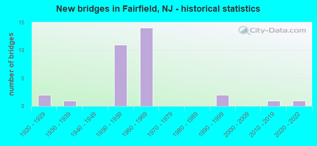
- New bridges - historical statistics
- 21920-1929
- 11930-1939
- 111950-1959
- 141960-1969
- 21990-1999
- 12010-2019
- 12020-2022

- Reconstructed bridges - Historical Statistics
- 11970-1979
- 31980-1989
- 11990-1999
- 12000-2009


- Bridge Condition - Deck
- 10.5%Very good
- 5.3%Good
- 42.1%Satisfactory
- 36.8%Fair
- 5.3%Poor

- Bridge Condition - Superstructure
- 10.5%Very good
- 10.5%Good
- 47.4%Satisfactory
- 31.6%Fair

- Bridge Condition - Substructure
- 5.3%Very good
- 31.6%Good
- 63.2%Satisfactory

- Bridge Condition - Channel
- 41.7%Good
- 50.0%Satisfactory
- 8.3%Fair

- Bridge Condition - Culverts
- 50.0%Excellent
- 50.0%Satisfactory
Find on map >> Show street view
Structure Number: 700005, Location: 0.25 mi S of US 46 (Lat: 40.886439, Lng: -74.272431), Route carried "on" structure: County highway 613, Year Built: 1995, Status: Open, Structure Length: 1.80m (5.91ft), Average Daily Traffic: 24,075 (year 2021), Truck Traffic: 4%, Average Future Daily Traffic: 28,891 (year 2041), Design Load: HS 20+Mod, Features Intersected: Deepavaal Brook, Facility Carried by Structure: Passaic Avenue
Minimum Vertical Clearance: 30+ m (98+ ft), Kilometerpoint: 8.900, Lanes on structure: 4, Base Highway Network: Yes, Owner: County Highway Agency, Approaching Roadway Width: 18.3m (60.0ft), Skew: 22 degrees, Material/Design: Prestressed concrete, Design/Construction: Box Beam or Girders - Multiple, Number Of Spans In Main Unit: 1, Length of Maximum Span: 16.8m (55.1ft), Curb or Sidewalk Widths: Left: 2.4m (7.9ft), Right: 2.4m (7.9ft), Curb-To-Curb Width: 18.3m (60.0ft), Out-to-Out Width: 23.8m (78.1ft)
Condition: Deck: Good, Superstructure: Satisfactory, Substructure: Good, Channel: Good, Inventory Rating: 58.1 metric tons, Method Used To Determine Inventory Rating: Load Factor (LF), Structural Evaluation: Equal to present minimum criteria, Deck Geometry: Somewhat better than minimum adequacy, Waterway Adequacy: Equal to present desirable criteria, Approach Roadway Alignment: Equal to present desirable criteria, Designated Inspection Frequency: Every 24 months, Inspection Date: July 2021, Deck Structure Type: Concrete Cast-file-Place, Wearing Surface/Protective System: Wearing Surface: Latex Concrete, Deck Protection: Epoxy Coated Reinforcing
Find on map >> Show street view
Structure Number: 700095, Location: 0.22 MI S OF GREENBROK RD (Lat: 40.870819, Lng: -74.279750), Route carried "on" structure: County highway 613, Year Built: 1921, Year Reconstructed: 1996, Status: Open, Structure Length: 1.13m (3.71ft), Average Daily Traffic: 23,860 (year 2020), Truck Traffic: 4%, Average Future Daily Traffic: 29,109 (year 2040), Design Load: H 20, Features Intersected: GREEN BROOK
Minimum Vertical Clearance: 30+ m (98+ ft), Kilometerpoint: 6.920, Lanes on structure: 5, Base Highway Network: Yes, Owner: County Highway Agency, Approaching Roadway Width: 18.3m (60.0ft), Material/Design: Concrete, Design/Construction: Culvert, Number Of Spans In Main Unit: 2, Length of Maximum Span: 4.9m (16.1ft), Curb or Sidewalk Widths: Left: 1.8m (5.9ft), Right: 1.8m (5.9ft), Curb-To-Curb Width: 18.3m (60.0ft), Out-to-Out Width: 22.6m (74.1ft)
Condition: Channel: Fair, Culverts: Satisfactory, Operating Rating: 40.8 metric tons, Method Used To Determine Operating Rating: Field evaluation and documented engineering judgment, Inventory Rating: 24.5 metric tons, Method Used To Determine Inventory Rating: Field evaluation and documented engineering judgment, Structural Evaluation: Equal to present minimum criteria, Deck Geometry: High priority of replacement, Waterway Adequacy: Equal to present desirable criteria, Approach Roadway Alignment: Equal to present desirable criteria, Length Of Structure Improvement: 1.13m (3.71ft), Designated Inspection Frequency: Every 24 months, Inspection Date: August 2020
Find on map >> Show street view
Structure Number: 701465, Location: .5MI W OF PASSAIC AVE. (Lat: 40.881731, Lng: -74.280419), Route carried "on" structure: County highway 662, Year Built: 2019, Status: Open, Structure Length: 1.10m (3.61ft), Average Daily Traffic: 8,100 (year 2019), Truck Traffic: 3%, Average Future Daily Traffic: 9,720 (year 2039), Design Load: HL 93, Features Intersected: Deepavaal Brook, Facility Carried by Structure: New Dutch Lane
Minimum Vertical Clearance: 30+ m (98+ ft), Kilometerpoint: 0.370, Lanes on structure: 2, Owner: County Highway Agency, Approaching Roadway Width: 12.2m (40.0ft), Material/Design: Concrete, Design/Construction: Culvert, Number Of Spans In Main Unit: 1, Number Of Approach Spans: 2, Length of Maximum Span: 11.0m (36.1ft), Curb-To-Curb Width: 12.2m (40.0ft), Out-to-Out Width: 13.3m (43.6ft)
Condition: Channel: Good, Culverts: Excellent, Operating Rating: 41.7 metric tons, Method Used To Determine Operating Rating: Field evaluation and documented engineering judgment, Inventory Rating: 32.7 metric tons, Method Used To Determine Inventory Rating: Field evaluation and documented engineering judgment, Structural Evaluation: Superior to present desirable criteria, Deck Geometry: Somewhat better than minimum adequacy, Waterway Adequacy: Better than present minimum criteria, Approach Roadway Alignment: Equal to present desirable criteria, Length Of Structure Improvement: 1.22m (4.00ft), Designated Inspection Frequency: Every 24 months, Inspection Date: March 2020, Bridge Improvement Cost: $419,000, Roadway Improvement Cost: $1,000, Total Project Cost: $420,000 ( Estimate for 2015)
Find on map >> Show street view
Structure Number: 701565, Location: 264 FT WEST OF PIER LANE (Lat: 40.887250, Lng: -74.266331), Route carried "on" structure: County highway 615, Year Built: 1994, Status: Open, Structure Length: 1.10m (3.61ft), Average Daily Traffic: 9,985 (year 2020), Truck Traffic: 4%, Average Future Daily Traffic: 12,182 (year 2040), Design Load: HS 20+Mod, Features Intersected: DEEPAVAAL BROOK
Minimum Vertical Clearance: 30+ m (98+ ft), Kilometerpoint: 4.281, Lanes on structure: 2, Owner: County Highway Agency, Approaching Roadway Width: 11.6m (38.1ft), Material/Design: Prestressed concrete, Design/Construction: Box Beam or Girders - Multiple, Number Of Spans In Main Unit: 1, Length of Maximum Span: 9.4m (30.8ft), Curb or Sidewalk Widths: Left: 0.0m, Right: 1.9m (6.2ft), Curb-To-Curb Width: 11.6m (38.1ft), Out-to-Out Width: 14.3m (46.9ft)
Condition: Deck: Fair, Superstructure: Fair, Substructure: Good, Channel: Satisfactory, Operating Rating: 89.8 metric tons, Method Used To Determine Operating Rating: Load Factor (LF), Inventory Rating: 89.8 metric tons, Method Used To Determine Inventory Rating: Load Factor (LF), Structural Evaluation: Somewhat better than minimum adequacy, Deck Geometry: Somewhat better than minimum adequacy, Waterway Adequacy: Equal to present desirable criteria, Approach Roadway Alignment: Equal to present desirable criteria, Designated Inspection Frequency: Every 24 months, Inspection Date: August 2020, Deck Structure Type: Concrete Cast-file-Place, Wearing Surface/Protective System: Wearing Surface: Monolithic Concrete, Deck Protection: Epoxy Coated Reinforcing
Find on map >> Show street view
Structure Number: 70M06, Location: 0.23 MILE N.OF I-80 (Lat: 40.896919, Lng: -74.272869), Route carried "on" structure: County highway 613, Year Built: 1928, Year Reconstructed: 1994, Status: Open, Structure Length: 8.17m (26.80ft), Average Daily Traffic: 10,951 (year 2020), Truck Traffic: 4%, Average Future Daily Traffic: 13,360 (year 2040), Design Load: H 20, Features Intersected: PASSAIC RIVER
Minimum Vertical Clearance: 30+ m (98+ ft), Kilometerpoint: 10.123, Lanes on structure: 2, Owner: County Highway Agency, Approaching Roadway Width: 9.8m (32.2ft), Material/Design: Steel, Design/Construction: Girder and Floorbeam System, Number Of Spans In Main Unit: 3, Length of Maximum Span: 26.2m (86.0ft), Curb or Sidewalk Widths: Left: 1.7m (5.6ft), Right: 1.7m (5.6ft), Curb-To-Curb Width: 9.1m (29.9ft), Out-to-Out Width: 9.6m (31.5ft)
Condition: Deck: Satisfactory, Superstructure: Fair, Substructure: Satisfactory, Channel: Good, Operating Rating: 51.7 metric tons, Method Used To Determine Operating Rating: Load Factor (LF), Inventory Rating: 30.8 metric tons, Method Used To Determine Inventory Rating: Load Factor (LF), Structural Evaluation: Somewhat better than minimum adequacy, Deck Geometry: Meets minimum limits, Waterway Adequacy: Better than present minimum criteria, Approach Roadway Alignment: Equal to present minimum criteria, Designated Inspection Frequency: Every 24 months, Critical Feature Inspection Frequency: Every 24 months, Inspection Date: September 2020, Critical Feature Inspection Date: September 2020, Deck Structure Type: Concrete Cast-file-Place, Wearing Surface/Protective System: Wearing Surface: Monolithic Concrete, Deck Protection: Epoxy Coated Reinforcing
Find on map >> Show street view
Structure Number: 72215, Location: 0.6 MI East of CR 627 (Lat: 40.873269, Lng: -74.302769), Route carried "on" structure: Ramp US 46, Year Built: 1952, Status: Open, Structure Length: 4.21m (13.81ft), Average Daily Traffic: 7,304 (year 2020), Truck Traffic: 4%, Average Future Daily Traffic: 8,912 (year 2040), Design Load: HS 20, Features Intersected: ROUTE US 46
Minimum Vertical Clearance: 30+ m (98+ ft), Kilometerpoint: 85.456, Lanes on structure: 2, Lanes under structure: 4, Owner: State Highway Agency, Approaching Roadway Width: 9.1m (29.9ft), Material/Design: Steel, Design/Construction: Stringer/Multi-beam, Number Of Spans In Main Unit: 2, Length of Maximum Span: 20.4m (66.9ft), Curb or Sidewalk Widths: Left: 1.2m (3.9ft), Right: 1.2m (3.9ft), Curb-To-Curb Width: 9.1m (29.9ft), Out-to-Out Width: 13.1m (43.0ft)
Condition: Deck: Fair, Superstructure: Satisfactory, Substructure: Satisfactory, Operating Rating: 76.2 metric tons, Method Used To Determine Operating Rating: Load Factor (LF), Inventory Rating: 45.4 metric tons, Method Used To Determine Inventory Rating: Load Factor (LF), Structural Evaluation: Equal to present minimum criteria, Deck Geometry: Meets minimum limits, Underclear: Somewhat better than minimum adequacy, Approach Roadway Alignment: Equal to present minimum criteria, Designated Inspection Frequency: Every 24 months, Inspection Date: March 2020, Deck Structure Type: Concrete Cast-file-Place, Wearing Surface/Protective System: Wearing Surface: Monolithic Concrete
Find on map >> Show street view
Structure Number: 722151, Location: 2.5 MILES WEST OF NJ 23 (Lat: 40.876961, Lng: -74.298919), Route carried "on" structure: County highway 626, Year Built: 1952, Status: Open, Structure Length: 6.46m (21.19ft), Average Daily Traffic: 3,960 (year 2020), Truck Traffic: 4%, Average Future Daily Traffic: 4,752 (year 2040), Design Load: H 20, Features Intersected: US 46
Minimum Vertical Clearance: 30+ m (98+ ft), Kilometerpoint: 3.685, Lanes on structure: 2, Lanes under structure: 4, Owner: State Highway Agency, Approaching Roadway Width: 9.1m (29.9ft), Skew: 4 degrees, Material/Design: Steel continuous, Design/Construction: Girder and Floorbeam System, Number Of Spans In Main Unit: 2, Length of Maximum Span: 32.0m (105.0ft), Curb or Sidewalk Widths: Left: 1.3m (4.3ft), Right: 1.3m (4.3ft), Curb-To-Curb Width: 9.1m (29.9ft), Out-to-Out Width: 13.3m (43.6ft)
Condition: Deck: Fair, Superstructure: Fair, Substructure: Satisfactory, Operating Rating: 71.7 metric tons, Method Used To Determine Operating Rating: Load Factor (LF), Inventory Rating: 42.6 metric tons, Method Used To Determine Inventory Rating: Load Factor (LF), Structural Evaluation: Somewhat better than minimum adequacy, Deck Geometry: Meets minimum limits, Underclear: Meets minimum limits, Approach Roadway Alignment: Equal to present minimum criteria, Designated Inspection Frequency: Every 24 months, Critical Feature Inspection Frequency: Every 24 months, Inspection Date: Febuary 2020, Critical Feature Inspection Date: Febuary 2020, Deck Structure Type: Concrete Cast-file-Place, Wearing Surface/Protective System: Wearing Surface: Monolithic Concrete
Find on map >> Show street view
Structure Number: 722152, Location: 2.1 MI. EAST OF RT. 159 (Lat: 40.881761, Lng: -74.291411), Route carried "on" structure: County highway 625, Year Built: 1952, Status: Open, Structure Length: 4.24m (13.91ft), Average Daily Traffic: 8,680 (year 2020), Truck Traffic: 3%, Average Future Daily Traffic: 10,400 (year 2040), Design Load: HS 20, Features Intersected: US 46
Minimum Vertical Clearance: 30+ m (98+ ft), Kilometerpoint: 3.138, Lanes on structure: 2, Lanes under structure: 6, Owner: State Highway Agency, Approaching Roadway Width: 9.1m (29.9ft), Material/Design: Steel, Design/Construction: Stringer/Multi-beam, Number Of Spans In Main Unit: 2, Length of Maximum Span: 20.7m (67.9ft), Curb or Sidewalk Widths: Left: 1.7m (5.6ft), Right: 1.7m (5.6ft), Curb-To-Curb Width: 9.1m (29.9ft), Out-to-Out Width: 13.7m (44.9ft)
Condition: Deck: Poor, Superstructure: Fair, Substructure: Satisfactory, Operating Rating: 64.4 metric tons, Method Used To Determine Operating Rating: Load Factor (LF), Inventory Rating: 38.1 metric tons, Method Used To Determine Inventory Rating: Load Factor (LF), Structural Evaluation: Somewhat better than minimum adequacy, Deck Geometry: High priority of corrective action, Underclear: Meets minimum limits, Approach Roadway Alignment: Equal to present minimum criteria, Length Of Structure Improvement: 5.12m (16.80ft), Designated Inspection Frequency: Every 24 months, Inspection Date: July 2020, Bridge Improvement Cost: $3,654,000, Roadway Improvement Cost: $200,000, Total Project Cost: $5,331,000 ( Estimate for 2020), Deck Structure Type: Concrete Cast-file-Place
Find on map >> Show street view
Structure Number: 722155, Location: 0.5 MI WEST OF RT. 23 (Lat: 40.886300, Lng: -74.282419), Route carried "on" structure: Ramp US 46, Year Built: 1951, Status: Open, Structure Length: 4.21m (13.81ft), Average Daily Traffic: 8,449 (year 2020), Truck Traffic: 4%, Average Future Daily Traffic: 10,309 (year 2040), Design Load: HS 20, Features Intersected: US ROUTE 46, Facility Carried by Structure: RAMP TO FAIRFIELD
Minimum Vertical Clearance: 30+ m (98+ ft), Kilometerpoint: 87.677, Lanes on structure: 2, Lanes under structure: 4, Owner: State Highway Agency, Approaching Roadway Width: 9.1m (29.9ft), Material/Design: Steel, Design/Construction: Stringer/Multi-beam, Number Of Spans In Main Unit: 2, Length of Maximum Span: 20.4m (66.9ft), Curb or Sidewalk Widths: Left: 1.8m (5.9ft), Right: 1.8m (5.9ft), Curb-To-Curb Width: 9.2m (30.2ft), Out-to-Out Width: 13.7m (44.9ft)
Condition: Deck: Fair, Superstructure: Satisfactory, Substructure: Satisfactory, Operating Rating: 72.6 metric tons, Method Used To Determine Operating Rating: Load Factor (LF), Inventory Rating: 43.5 metric tons, Method Used To Determine Inventory Rating: Load Factor (LF), Structural Evaluation: Equal to present minimum criteria, Deck Geometry: Somewhat better than minimum adequacy, Underclear: Equal to present minimum criteria, Approach Roadway Alignment: Equal to present minimum criteria, Designated Inspection Frequency: Every 24 months, Inspection Date: March 2020, Deck Structure Type: Concrete Cast-file-Place, Wearing Surface/Protective System: Wearing Surface: Bituminous
Find on map >> Show street view
Structure Number: 722156, Location: 0.27 MI SOUTH OF I-80 (Lat: 40.889739, Lng: -74.273719), Route carried "on" structure: County highway 613, Year Built: 1950, Year Reconstructed: 1984, Status: Open, Structure Length: 4.24m (13.91ft), Average Daily Traffic: 19,100 (year 2020), Truck Traffic: 4%, Average Future Daily Traffic: 22,900 (year 2040), Design Load: HS 20+Mod, Features Intersected: US 46, Facility Carried by Structure: TWO BRIDGES ROAD
Minimum Vertical Clearance: 30+ m (98+ ft), Kilometerpoint: 9.286, Lanes on structure: 4, Lanes under structure: 5, Base Highway Network: Yes, Owner: State Highway Agency, Approaching Roadway Width: 15.2m (49.9ft), Material/Design: Steel, Design/Construction: Stringer/Multi-beam, Number Of Spans In Main Unit: 2, Length of Maximum Span: 21.0m (68.9ft), Curb or Sidewalk Widths: Left: 1.8m (5.9ft), Right: 1.8m (5.9ft), Curb-To-Curb Width: 15.3m (50.2ft), Out-to-Out Width: 19.5m (64.0ft)
Condition: Deck: Satisfactory, Superstructure: Satisfactory, Substructure: Satisfactory, Operating Rating: 60.8 metric tons, Method Used To Determine Operating Rating: Load Factor (LF), Inventory Rating: 36.3 metric tons, Method Used To Determine Inventory Rating: Load Factor (LF), Structural Evaluation: Equal to present minimum criteria, Deck Geometry: High priority of corrective action, Underclear: Equal to present minimum criteria, Approach Roadway Alignment: Equal to present minimum criteria, Designated Inspection Frequency: Every 24 months, Inspection Date: July 2020, Deck Structure Type: Concrete Cast-file-Place, Wearing Surface/Protective System: Wearing Surface: Latex Concrete
Find on map >> Show street view
Structure Number: 722157, Location: 0.5 MI WEST OF RT NJ 23 (Lat: 40.892200, Lng: -74.266081), Route carried "on" structure: US 46, Year Built: 2020, Status: Open, Structure Length: 8.96m (29.40ft), Average Daily Traffic: 30,086 (year 2021), Truck Traffic: 4%, Average Future Daily Traffic: 36,103 (year 2041), Design Load: HL 93, Features Intersected: PASSAIC RIVER
Minimum Vertical Clearance: 30+ m (98+ ft), Kilometerpoint: 89.238, Lanes on structure: 3, Base Highway Network: Yes, Owner: State Highway Agency, Approaching Roadway Width: 17.7m (58.1ft), Material/Design: Prestressed concrete, Design/Construction: Stringer/Multi-beam, Number Of Spans In Main Unit: 3, Length of Maximum Span: 31.1m (102.0ft), Curb or Sidewalk Widths: Left: 0.0m, Right: 2.4m (7.9ft), Curb-To-Curb Width: 17.7m (58.1ft), Out-to-Out Width: 19.0m (62.3ft)
Condition: Deck: Very good, Superstructure: Very good, Substructure: Very good, Channel: Satisfactory, Operating Rating: 68.0 metric tons, Method Used To Determine Operating Rating: Field evaluation and documented engineering judgment, Inventory Rating: 40.8 metric tons, Method Used To Determine Inventory Rating: Field evaluation and documented engineering judgment, Structural Evaluation: Equal to present desirable criteria, Deck Geometry: Superior to present desirable criteria, Waterway Adequacy: Equal to present desirable criteria, Approach Roadway Alignment: Better than present minimum criteria, Designated Inspection Frequency: Every 24 months, Underwater Inspection Frequency: Every 48 months, Inspection Date: April 2021, Underwater Inspection Date: April 2021, Bridge Improvement Cost: $3,840,000, Roadway Improvement Cost: $325,000, Total Project Cost: $6,017,000 ( Estimate for 2019), Deck Structure Type: Concrete Cast-file-Place, Wearing Surface/Protective System: Wearing Surface: Monolithic Concrete, Deck Protection: Epoxy Coated Reinforcing
Find on map >> Show street view
Structure Number: 722158, Location: 0.53 MI WEST OF RT NJ 23 (Lat: 40.892469, Lng: -74.266211), Route carried "on" structure: US 46, Year Built: 1951, Status: Open, Structure Length: 7.59m (24.90ft), Average Daily Traffic: 30,086 (year 2021), Truck Traffic: 4%, Average Future Daily Traffic: 36,103 (year 2041), Design Load: HS 20, Features Intersected: PASSAIC RIVER
Minimum Vertical Clearance: 30+ m (98+ ft), Kilometerpoint: 89.238, Lanes on structure: 3, Base Highway Network: Yes, Owner: State Highway Agency, Approaching Roadway Width: 11.6m (38.1ft), Material/Design: Steel continuous, Design/Construction: Stringer/Multi-beam, Number Of Spans In Main Unit: 3, Length of Maximum Span: 25.3m (83.0ft), Curb or Sidewalk Widths: Left: 2.2m (7.2ft), Right: 0.6m (2.0ft), Curb-To-Curb Width: 11.6m (38.1ft), Out-to-Out Width: 15.8m (51.8ft)
Condition: Deck: Fair, Superstructure: Good, Substructure: Satisfactory, Channel: Satisfactory, Operating Rating: 50.8 metric tons, Method Used To Determine Operating Rating: Load Factor (LF), Inventory Rating: 29.9 metric tons, Method Used To Determine Inventory Rating: Load Factor (LF), Structural Evaluation: Equal to present minimum criteria, Deck Geometry: High priority of replacement, Waterway Adequacy: Equal to present minimum criteria, Approach Roadway Alignment: Better than present minimum criteria, Length Of Structure Improvement: 7.59m (24.90ft), Designated Inspection Frequency: Every 24 months, Underwater Inspection Frequency: Every 24 months, Inspection Date: April 2021, Underwater Inspection Date: April 2021, Bridge Improvement Cost: $32,000, Roadway Improvement Cost: $11,000, Total Project Cost: $2,370,000 ( Estimate for 2021), Deck Structure Type: Concrete Cast-file-Place, Wearing Surface/Protective System: Wearing Surface: Monolithic Concrete
Find on map >> Show street view
Structure Number: 72615, Location: 2.7 MI EAST OF RTE 46 (Lat: 40.878039, Lng: -74.327231), Route carried "on" structure: Interstate 80, Year Built: 1967, Status: Open, Structure Length: 7.10m (23.29ft), Average Daily Traffic: 66,595 (year 2020), Truck Traffic: 9%, Average Future Daily Traffic: 79,914 (year 2040), Design Load: HS 20, Features Intersected: HORSENECK RD,WATER SUPP.
Minimum Vertical Clearance: 30+ m (98+ ft), Kilometerpoint: 79.228, Lanes on structure: 3, Lanes under structure: 2, Base Highway Network: Yes, Owner: State Highway Agency, Approaching Roadway Width: 15.5m (50.9ft), Material/Design: Steel, Design/Construction: Stringer/Multi-beam, Number Of Spans In Main Unit: 4, Length of Maximum Span: 26.8m (87.9ft), Curb or Sidewalk Widths: Left: 0.5m (1.6ft), Right: 0.5m (1.6ft), Curb-To-Curb Width: 15.5m (50.9ft), Out-to-Out Width: 17.1m (56.1ft)
Condition: Deck: Fair, Superstructure: Satisfactory, Substructure: Satisfactory, Operating Rating: 78.0 metric tons, Method Used To Determine Operating Rating: Load Factor (LF), Inventory Rating: 46.3 metric tons, Method Used To Determine Inventory Rating: Load Factor (LF), Structural Evaluation: Equal to present minimum criteria, Deck Geometry: Somewhat better than minimum adequacy, Underclear: High priority of corrective action, Approach Roadway Alignment: Equal to present desirable criteria, Length Of Structure Improvement: 1.71m (5.61ft), Designated Inspection Frequency: Every 24 months, Inspection Date: October 2020, Roadway Improvement Cost: $92,000, Total Project Cost: $116,000 ( Estimate for 2020), Deck Structure Type: Concrete Cast-file-Place, Wearing Surface/Protective System: Wearing Surface: Monolithic Concrete, Deck Protection: Cathodic Protection
Find on map >> Show street view
Structure Number: 726151, Location: 2.7 MI EAST OF RTE 46 (Lat: 40.878619, Lng: -74.327400), Route carried "on" structure: Interstate 80, Year Built: 1967, Status: Open, Structure Length: 5.79m (19.00ft), Average Daily Traffic: 66,595 (year 2020), Truck Traffic: 9%, Average Future Daily Traffic: 79,914 (year 2040), Design Load: HS 20, Features Intersected: HORSENECK RD & WATER SUP
Minimum Vertical Clearance: 30+ m (98+ ft), Kilometerpoint: 79.228, Lanes on structure: 3, Lanes under structure: 2, Base Highway Network: Yes, Owner: State Highway Agency, Approaching Roadway Width: 15.5m (50.9ft), Material/Design: Steel, Design/Construction: Stringer/Multi-beam, Number Of Spans In Main Unit: 4, Length of Maximum Span: 23.2m (76.1ft), Curb or Sidewalk Widths: Left: 0.5m (1.6ft), Right: 0.5m (1.6ft), Curb-To-Curb Width: 15.5m (50.9ft), Out-to-Out Width: 17.1m (56.1ft)
Condition: Deck: Satisfactory, Superstructure: Satisfactory, Substructure: Satisfactory, Operating Rating: 70.8 metric tons, Method Used To Determine Operating Rating: Load Factor (LF), Inventory Rating: 41.7 metric tons, Method Used To Determine Inventory Rating: Load Factor (LF), Structural Evaluation: Equal to present minimum criteria, Deck Geometry: Somewhat better than minimum adequacy, Underclear: High priority of corrective action, Approach Roadway Alignment: Equal to present desirable criteria, Length Of Structure Improvement: 4.57m (14.99ft), Designated Inspection Frequency: Every 24 months, Inspection Date: October 2020, Roadway Improvement Cost: $122,000, Total Project Cost: $150,000 ( Estimate for 2020), Deck Structure Type: Concrete Cast-file-Place, Wearing Surface/Protective System: Wearing Surface: Bituminous, Deck Protection: Cathodic Protection
Find on map >> Show street view
Structure Number: 726153, Location: 1.16 MILES W OF NJ 23 SB (Lat: 40.893669, Lng: -74.273581), Route carried "on" structure: Interstate 80, Year Built: 1967, Status: Open, Structure Length: 2.77m (9.09ft), Average Daily Traffic: 61,720 (year 2021), Truck Traffic: 9%, Average Future Daily Traffic: 74,064 (year 2041), Design Load: HS 20, Features Intersected: TWO BRIDGES ROAD
Minimum Vertical Clearance: 30+ m (98+ ft), Kilometerpoint: 84.444, Lanes on structure: 3, Lanes under structure: 4, Base Highway Network: Yes, Owner: State Highway Agency, Approaching Roadway Width: 15.5m (50.9ft), Skew: 1 degrees, Material/Design: Prestressed concrete, Design/Construction: Stringer/Multi-beam, Number Of Spans In Main Unit: 1, Length of Maximum Span: 25.9m (85.0ft), Curb or Sidewalk Widths: Left: 0.5m (1.6ft), Right: 0.5m (1.6ft), Curb-To-Curb Width: 15.5m (50.9ft), Out-to-Out Width: 17.1m (56.1ft)
Condition: Deck: Fair, Superstructure: Good, Substructure: Satisfactory, Operating Rating: 54.4 metric tons, Method Used To Determine Operating Rating: Field evaluation and documented engineering judgment, Inventory Rating: 32.7 metric tons, Method Used To Determine Inventory Rating: Field evaluation and documented engineering judgment, Structural Evaluation: Equal to present minimum criteria, Deck Geometry: Somewhat better than minimum adequacy, Underclear: Meets minimum limits, Approach Roadway Alignment: Equal to present desirable criteria, Designated Inspection Frequency: Every 24 months, Inspection Date: June 2021, Deck Structure Type: Concrete Cast-file-Place, Wearing Surface/Protective System: Wearing Surface: Latex Concrete
Find on map >> Show street view
Structure Number: 726154, Location: 1.0 Mi west of NJ Transit (Lat: 40.894089, Lng: -74.273119), Route carried "on" structure: Interstate 80, Year Built: 1967, Status: Open, Structure Length: 2.77m (9.09ft), Average Daily Traffic: 60,800 (year 2020), Truck Traffic: 9%, Average Future Daily Traffic: 72,960 (year 2040), Design Load: HS 20+Mod, Features Intersected: TWO BRIDGES RD (CR613)
Minimum Vertical Clearance: 30+ m (98+ ft), Kilometerpoint: 84.458, Lanes on structure: 4, Lanes under structure: 4, Base Highway Network: Yes, Owner: State Highway Agency, Approaching Roadway Width: 15.8m (51.8ft), Skew: 1 degrees, Material/Design: Prestressed concrete, Design/Construction: Stringer/Multi-beam, Number Of Spans In Main Unit: 1, Length of Maximum Span: 25.9m (85.0ft), Curb-To-Curb Width: 15.9m (52.2ft), Out-to-Out Width: 17.4m (57.1ft)
Condition: Deck: Satisfactory, Superstructure: Satisfactory, Substructure: Satisfactory, Operating Rating: 68.9 metric tons, Method Used To Determine Operating Rating: Load Factor (LF), Inventory Rating: 33.6 metric tons, Method Used To Determine Inventory Rating: Load Factor (LF), Structural Evaluation: Equal to present minimum criteria, Deck Geometry: High priority of replacement, Underclear: Meets minimum limits, Approach Roadway Alignment: Equal to present desirable criteria, Length Of Structure Improvement: 2.77m (9.09ft), Designated Inspection Frequency: Every 24 months, Inspection Date: Febuary 2020, Bridge Improvement Cost: $186,000, Roadway Improvement Cost: $20,000, Total Project Cost: $295,000 ( Estimate for 2020), Deck Structure Type: Concrete Cast-file-Place, Wearing Surface/Protective System: Wearing Surface: Bituminous, Deck Protection: Cathodic Protection
Find on map >> Show street view
Structure Number: 726155, Location: 0.75 MI WEST OF NJ 23 SB (Lat: 40.894031, Lng: -74.267039), Route carried "on" structure: Interstate 80, Year Built: 1967, Year Reconstructed: 1988, Status: Open, Structure Length: 11.89m (39.01ft), Average Daily Traffic: 60,900 (year 2021), Truck Traffic: 9%, Average Future Daily Traffic: 73,100 (year 2041), Design Load: HS 20, Features Intersected: PASSAIC RIVER & FRFLD RD
Minimum Vertical Clearance: 30+ m (98+ ft), Kilometerpoint: 85.070, Lanes on structure: 3, Lanes under structure: 2, Base Highway Network: Yes, Owner: State Highway Agency, Approaching Roadway Width: 15.5m (50.9ft), Skew: 32 degrees, Material/Design: Steel continuous, Design/Construction: Stringer/Multi-beam, Number Of Spans In Main Unit: 3, Length of Maximum Span: 45.7m (149.9ft), Curb-To-Curb Width: 15.5m (50.9ft), Out-to-Out Width: 17.1m (56.1ft)
Condition: Deck: Satisfactory, Superstructure: Fair, Substructure: Good, Channel: Good, Operating Rating: 48.1 metric tons, Method Used To Determine Operating Rating: Load Factor (LF), Inventory Rating: 29.0 metric tons, Method Used To Determine Inventory Rating: Load Factor (LF), Structural Evaluation: Somewhat better than minimum adequacy, Deck Geometry: Somewhat better than minimum adequacy, Underclear: Equal to present minimum criteria, Waterway Adequacy: Superior to present desirable criteria, Approach Roadway Alignment: Equal to present desirable criteria, Designated Inspection Frequency: Every 24 months, Underwater Inspection Frequency: Every 48 months, Inspection Date: September 2021, Underwater Inspection Date: October 2019, Deck Structure Type: Concrete Cast-file-Place, Wearing Surface/Protective System: Wearing Surface: Latex Concrete, Deck Protection: Cathodic Protection
Find on map >> Show street view
Structure Number: 726156, Location: 0.75 MI WEST OF NJ 23 SB (Lat: 40.894511, Lng: -74.265900), Route carried "on" structure: Interstate 80, Year Built: 1967, Year Reconstructed: 1988, Status: Open, Structure Length: 11.89m (39.01ft), Average Daily Traffic: 60,900 (year 2021), Truck Traffic: 9%, Average Future Daily Traffic: 73,100 (year 2041), Design Load: HS 20, Features Intersected: PASSAIC RIVER & FRFLD RD
Minimum Vertical Clearance: 30+ m (98+ ft), Kilometerpoint: 85.070, Lanes on structure: 3, Lanes under structure: 2, Base Highway Network: Yes, Owner: State Highway Agency, Approaching Roadway Width: 15.5m (50.9ft), Skew: 2 degrees, Material/Design: Steel continuous, Design/Construction: Stringer/Multi-beam, Number Of Spans In Main Unit: 3, Length of Maximum Span: 45.7m (149.9ft), Curb-To-Curb Width: 15.5m (50.9ft), Out-to-Out Width: 17.1m (56.1ft)
Condition: Deck: Satisfactory, Superstructure: Satisfactory, Substructure: Good, Channel: Satisfactory, Operating Rating: 48.1 metric tons, Method Used To Determine Operating Rating: Load Factor (LF), Inventory Rating: 28.1 metric tons, Method Used To Determine Inventory Rating: Load Factor (LF), Structural Evaluation: Equal to present minimum criteria, Deck Geometry: Somewhat better than minimum adequacy, Underclear: Equal to present minimum criteria, Waterway Adequacy: Superior to present desirable criteria, Approach Roadway Alignment: Equal to present desirable criteria, Designated Inspection Frequency: Every 24 months, Underwater Inspection Frequency: Every 48 months, Inspection Date: September 2021, Underwater Inspection Date: October 2019, Deck Structure Type: Concrete Cast-file-Place, Wearing Surface/Protective System: Wearing Surface: Bituminous, Deck Protection: Cathodic Protection
Find on map >> Show street view
Structure Number: 1415157, Location: 2.0 MI EAST OF US 46 (Lat: 40.866989, Lng: -74.330981), Route carried "on" structure: Interstate 80, Year Built: 1968, Status: Open, Structure Length: 9.94m (32.61ft), Average Daily Traffic: 29,760 (year 2021), Truck Traffic: 9%, Average Future Daily Traffic: 35,700 (year 2041), Design Load: HS 20, Features Intersected: PASSAIC RIVER
Minimum Vertical Clearance: 30+ m (98+ ft), Kilometerpoint: 78.005, Lanes on structure: 3, Base Highway Network: Yes, Owner: State Highway Agency, Approaching Roadway Width: 15.5m (50.9ft), Skew: 1 degrees, Material/Design: Steel, Design/Construction: Stringer/Multi-beam, Number Of Spans In Main Unit: 3, Length of Maximum Span: 36.3m (119.1ft), Curb-To-Curb Width: 15.5m (50.9ft), Out-to-Out Width: 17.1m (56.1ft)
Condition: Deck: Satisfactory, Superstructure: Satisfactory, Substructure: Good, Channel: Satisfactory, Operating Rating: 60.8 metric tons, Method Used To Determine Operating Rating: Load Factor (LF), Inventory Rating: 36.3 metric tons, Method Used To Determine Inventory Rating: Load Factor (LF), Structural Evaluation: Equal to present minimum criteria, Deck Geometry: Somewhat better than minimum adequacy, Waterway Adequacy: Superior to present desirable criteria, Approach Roadway Alignment: Equal to present desirable criteria, Designated Inspection Frequency: Every 24 months, Underwater Inspection Frequency: Every 48 months, Inspection Date: September 2021, Underwater Inspection Date: October 2019, Deck Structure Type: Concrete Cast-file-Place, Wearing Surface/Protective System: Wearing Surface: Latex Concrete, Deck Protection: Cathodic Protection
Find on map >> Show street view
Structure Number: 1415158, Location: 2.0 MI EAST OF US 46 (Lat: 40.868189, Lng: -74.331239), Route carried "on" structure: Interstate 80, Year Built: 1968, Status: Open, Structure Length: 10.21m (33.50ft), Average Daily Traffic: 29,760 (year 2021), Truck Traffic: 9%, Average Future Daily Traffic: 35,700 (year 2041), Design Load: HS 20, Features Intersected: PASSAIC RIVER
Minimum Vertical Clearance: 30+ m (98+ ft), Kilometerpoint: 78.005, Lanes on structure: 3, Base Highway Network: Yes, Owner: State Highway Agency, Approaching Roadway Width: 15.5m (50.9ft), Skew: 1 degrees, Material/Design: Steel, Design/Construction: Stringer/Multi-beam, Number Of Spans In Main Unit: 3, Length of Maximum Span: 37.8m (124.0ft), Curb-To-Curb Width: 15.5m (50.9ft), Out-to-Out Width: 17.1m (56.1ft)
Condition: Deck: Satisfactory, Superstructure: Fair, Substructure: Satisfactory, Channel: Satisfactory, Operating Rating: 64.4 metric tons, Method Used To Determine Operating Rating: Load Factor (LF), Inventory Rating: 38.1 metric tons, Method Used To Determine Inventory Rating: Load Factor (LF), Structural Evaluation: Somewhat better than minimum adequacy, Deck Geometry: Somewhat better than minimum adequacy, Waterway Adequacy: Superior to present desirable criteria, Approach Roadway Alignment: Equal to present desirable criteria, Designated Inspection Frequency: Every 24 months, Underwater Inspection Frequency: Every 48 months, Inspection Date: September 2021, Underwater Inspection Date: October 2019, Deck Structure Type: Concrete Cast-file-Place, Wearing Surface/Protective System: Wearing Surface: Latex Concrete, Deck Protection: Cathodic Protection
Find on map >> Show street view
Structure Number: 1430153, Location: 0.7 MI E OF 46-159 JCT. (Lat: 40.858500, Lng: -74.318931), Route carried "on" structure: State highway 159, Year Built: 1939, Year Reconstructed: 2013, Status: Open, Structure Length: 6.83m (22.41ft), Average Daily Traffic: 9,695 (year 2021), Truck Traffic: 4%, Average Future Daily Traffic: 11,635 (year 2041), Design Load: HL 93, Features Intersected: PASSAIC RIVER
Minimum Vertical Clearance: 30+ m (98+ ft), Kilometerpoint: 0.515, Lanes on structure: 2, Base Highway Network: Yes, Owner: State Highway Agency, Approaching Roadway Width: 10.1m (33.1ft), Skew: 30 degrees, Material/Design: Prestressed concrete, Design/Construction: Stringer/Multi-beam, Number Of Spans In Main Unit: 4, Length of Maximum Span: 17.1m (56.1ft), Curb or Sidewalk Widths: Left: 1.3m (4.3ft), Right: 3.5m (11.5ft), Curb-To-Curb Width: 10.1m (33.1ft), Out-to-Out Width: 15.7m (51.5ft)
Condition: Deck: Very good, Superstructure: Very good, Substructure: Good, Channel: Good, Operating Rating: 52.2 metric tons, Method Used To Determine Operating Rating: Load and Resistance Factor Rating (LRFR) rating reported by rating factor(RF) method using HL-93 loadings, Inventory Rating: 40.8 metric tons, Method Used To Determine Inventory Rating: Load and Resistance Factor Rating (LRFR) rating reported by rating factor(RF) method using HL-93 loadings, Structural Evaluation: Better than present minimum criteria, Deck Geometry: Somewhat better than minimum adequacy, Waterway Adequacy: Better than present minimum criteria, Approach Roadway Alignment: Equal to present desirable criteria, Designated Inspection Frequency: Every 24 months, Underwater Inspection Frequency: Every 48 months, Inspection Date: August 2021, Underwater Inspection Date: September 2019, Deck Structure Type: Concrete Cast-file-Place, Wearing Surface/Protective System: Wearing Surface: Bituminous, Membrane: Other, Deck Protection: Epoxy Coated Reinforcing
Find on map >> Show street view
Structure Number: 72215, Location: 0.6 MI East of CR 627 (Lat: 40.873269, Lng: -74.302769), Route carried "under" structure: US 46, Year Built: 1952, Structure Length: 0. m, Average Daily Traffic: 62,167 (year 2020), Truck Traffic: 4%, Features Intersected: ROUTE US 46
Minimum Vertical Clearance: 4.47m (14.67ft), Kilometerpoint: 85.456, Lanes on structure: 2, Lanes under structure: 4, Material/Design: Steel, Design/Construction: Stringer/Multi-beam, Length of Maximum Span: 20.4m (66.9ft)
Find on map >> Show street view
Structure Number: 722151, Location: 2.5 MILES WEST OF NJ 23 (Lat: 40.876961, Lng: -74.298919), Route carried "under" structure: US 46, Year Built: 1952, Structure Length: 0. m, Average Daily Traffic: 47,280 (year 2020), Truck Traffic: 4%, Features Intersected: US 46, Facility Carried by Structure: HORSENECK RD CR626
Minimum Vertical Clearance: 4.67m (15.32ft), Kilometerpoint: 85.939, Lanes on structure: 2, Lanes under structure: 4, Material/Design: Steel continuous, Design/Construction: Girder and Floorbeam System, Length of Maximum Span: 32.0m (105.0ft)
Find on map >> Show street view
Structure Number: 722152, Location: 2.1 MI. EAST OF RT. 159 (Lat: 40.881761, Lng: -74.291411), Route carried "under" structure: US 46, Year Built: 1952, Structure Length: 0. m, Average Daily Traffic: 47,300 (year 2020), Truck Traffic: 4%, Features Intersected: US 46, Facility Carried by Structure: HLYWD AVE(CR 625)
Minimum Vertical Clearance: 4.44m (14.57ft), Kilometerpoint: 86.776, Lanes on structure: 2, Lanes under structure: 4, Material/Design: Steel, Design/Construction: Stringer/Multi-beam, Length of Maximum Span: 20.7m (67.9ft)
Find on map >> Show street view
Structure Number: 722155, Location: 0.5 MI WEST OF RT. 23 (Lat: 40.886300, Lng: -74.282419), Route carried "under" structure: US 46, Year Built: 1951, Structure Length: 0. m, Average Daily Traffic: 62,167 (year 2020), Truck Traffic: 4%, Features Intersected: US ROUTE 46, Facility Carried by Structure: RAMP TO FAIRFIELD
Minimum Vertical Clearance: 4.60m (15.09ft), Kilometerpoint: 87.677, Lanes on structure: 2, Lanes under structure: 4, Material/Design: Steel, Design/Construction: Stringer/Multi-beam, Length of Maximum Span: 20.4m (66.9ft)
Find on map >> Show street view
Structure Number: 722156, Location: 0.27 MI SOUTH OF I-80 (Lat: 40.889739, Lng: -74.273719), Route carried "under" structure: US 46, Year Built: 1950, Structure Length: 0. m, Average Daily Traffic: 59,600 (year 2020), Truck Traffic: 4%, Features Intersected: US 46, Facility Carried by Structure: TWO BRIDGES ROAD
Minimum Vertical Clearance: 4.85m (15.91ft), Kilometerpoint: 88.498, Lanes on structure: 4, Lanes under structure: 5, Material/Design: Steel, Design/Construction: Stringer/Multi-beam, Length of Maximum Span: 21.0m (68.9ft)
Find on map >> Show street view
Structure Number: 72615, Location: 2.7 MI EAST OF RTE 46 (Lat: 40.878039, Lng: -74.327231), Route carried "under" structure: County highway 626, Year Built: 1967, Structure Length: 0. m, Average Daily Traffic: 5,344 (year 2020), Truck Traffic: 4%, Features Intersected: HORSENECK RD,WATER SUPP., Facility Carried by Structure: I-80 EB
Minimum Vertical Clearance: 4.22m (13.85ft), Kilometerpoint: 1.175, Lanes on structure: 3, Lanes under structure: 2, Material/Design: Steel, Design/Construction: Stringer/Multi-beam, Length of Maximum Span: 26.8m (87.9ft)
Find on map >> Show street view
Structure Number: 726151, Location: 2.7 MI EAST OF RTE 46 (Lat: 40.878619, Lng: -74.327400), Route carried "under" structure: County highway 626, Year Built: 1967, Structure Length: 0. m, Average Daily Traffic: 5,239 (year 2020), Truck Traffic: 4%, Features Intersected: HORSENECK RD & WATER SUP, Facility Carried by Structure: RT. I-80 WB
Minimum Vertical Clearance: 4.22m (13.85ft), Kilometerpoint: 1.175, Lanes on structure: 3, Lanes under structure: 2, Material/Design: Steel, Design/Construction: Stringer/Multi-beam, Length of Maximum Span: 23.2m (76.1ft)
Find on map >> Show street view
Structure Number: 726153, Location: 1.16 MILES W OF NJ 23 SB (Lat: 40.893669, Lng: -74.273581), Route carried "under" structure: County highway 613, Year Built: 1967, Structure Length: 0. m, Average Daily Traffic: 11,159 (year 2021), Truck Traffic: 4%, Features Intersected: TWO BRIDGES ROAD, Facility Carried by Structure: I-80 EASTBOUND
Minimum Vertical Clearance: 4.72m (15.49ft), Kilometerpoint: 9.737, Lanes on structure: 3, Lanes under structure: 4, Material/Design: Prestressed concrete, Design/Construction: Stringer/Multi-beam, Length of Maximum Span: 25.9m (85.0ft)
Find on map >> Show street view
Structure Number: 726154, Location: 1.0 Mi west of NJ Transit (Lat: 40.894089, Lng: -74.273119), Route carried "under" structure: County highway 613, Year Built: 1967, Structure Length: 0. m, Average Daily Traffic: 10,924 (year 2020), Truck Traffic: 4%, Features Intersected: TWO BRIDGES RD (CR613), Facility Carried by Structure: I-80 WB, RAMP A
Minimum Vertical Clearance: 4.44m (14.57ft), Kilometerpoint: 9.737, Lanes on structure: 4, Lanes under structure: 4, Material/Design: Prestressed concrete, Design/Construction: Stringer/Multi-beam, Length of Maximum Span: 25.9m (85.0ft)
Find on map >> Show street view
Structure Number: 726155, Location: 0.75 MI WEST OF NJ 23 SB (Lat: 40.894031, Lng: -74.267039), Route carried "under" structure: County highway 679, Year Built: 1967, Structure Length: 0. m, Average Daily Traffic: 3,510 (year 2021), Truck Traffic: 3%, Features Intersected: PASSAIC RIVER & FRFLD RD, Facility Carried by Structure: I-80 EB
Minimum Vertical Clearance: 4.52m (14.83ft), Kilometerpoint: 0.177, Lanes on structure: 3, Lanes under structure: 2, Material/Design: Steel continuous, Design/Construction: Stringer/Multi-beam, Length of Maximum Span: 45.7m (149.9ft)
Find on map >> Show street view
Structure Number: 726156, Location: 0.75 MI WEST OF NJ 23 SB (Lat: 40.894511, Lng: -74.265900), Route carried "under" structure: County highway 679, Year Built: 1967, Structure Length: 0. m, Average Daily Traffic: 3,510 (year 2021), Truck Traffic: 3%, Features Intersected: PASSAIC RIVER & FRFLD RD, Facility Carried by Structure: I-80 WB
Minimum Vertical Clearance: 4.52m (14.83ft), Kilometerpoint: 0.177, Lanes on structure: 3, Lanes under structure: 2, Material/Design: Steel continuous, Design/Construction: Stringer/Multi-beam, Length of Maximum Span: 45.7m (149.9ft)