Bridge Statistics for Fair Oaks, Virginia (VA)
Condition, Traffic, Stress, Structural Evaluation, Project Costs
- National Bridge Inventory (NBI) Statistics
- 32Number of bridges
- 240ft / 73.3mTotal length
- $565,000Total costs
- 871,101Total average daily traffic
- 19,063Total average daily truck traffic
- National Bridge Inventory (NBI) Registered Bridges for Fair Oaks
- No street view available for this location
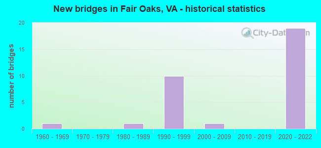
- New bridges - historical statistics
- 11960-1969
- 11980-1989
- 101990-1999
- 12000-2009
- 192020-2022


- Bridge Condition - Deck
- 66.7%Excellent
- 16.7%Good
- 16.7%Satisfactory

- Bridge Condition - Superstructure
- 66.7%Excellent
- 33.3%Satisfactory

- Bridge Condition - Substructure
- 66.7%Excellent
- 16.7%Good
- 16.7%Satisfactory

- Bridge Condition - Channel
- 25.0%Good
- 25.0%Satisfactory
- 50.0%Fair

- Bridge Condition - Culverts
- 50.0%Good
- 25.0%Satisfactory
- 25.0%Fair
Find on map >> Show street view
Structure Number: 6331, Location: 02.25FR286/00.08TO50 (Lat: 38.862050, Lng: -77.346156), Route carried "on" structure: Interstate 66, Year Built: 1964, Status: Open, Structure Length: 0.61m (2.00ft), Average Daily Traffic: 140,285 (year 2020), Truck Traffic: 3%, Average Future Daily Traffic: 196,399 (year 2040), Design Load: HS 20, Features Intersected: DIFFICULT RUN
Minimum Vertical Clearance: 30+ m (98+ ft), Kilometerpoint: 93.065, Lanes on structure: 9, Base Highway Network: Yes, Owner: State Highway Agency, Approaching Roadway Width: 19.8m (65.0ft), Skew: 2 degrees, Material/Design: Concrete, Design/Construction: Culvert, Number Of Spans In Main Unit: 3, Length of Maximum Span: 2.1m (6.9ft)
Condition: Channel: Fair, Culverts: Fair, Operating Rating: 89.8 metric tons, Method Used To Determine Operating Rating: Load Factor (LF), Inventory Rating: 89.7 metric tons, Method Used To Determine Inventory Rating: Load Factor (LF), Structural Evaluation: Somewhat better than minimum adequacy, Waterway Adequacy: Equal to present desirable criteria, Approach Roadway Alignment: Equal to present desirable criteria, Length Of Structure Improvement: 27.68m (90.81ft), Designated Inspection Frequency: Every 24 months, Inspection Date: July 2020, Bridge Improvement Cost: $25,000, Roadway Improvement Cost: $99,000, Total Project Cost: $150,000 ( Estimate for 2014)
Find on map >> Show street view
Structure Number: 6664, Location: 00.32FR6751/00.68TO788 (Lat: 38.868094, Lng: -77.364597), Route carried "on" structure: County highway 608, Year Built: 1991, Status: Open, Structure Length: 6.19m (20.31ft), Average Daily Traffic: 20,565 (year 2020), Truck Traffic: 4%, Average Future Daily Traffic: 26,526 (year 2040), Design Load: HL 93, Features Intersected: LEE JACKSON MEM.HWY.(50), Facility Carried by Structure: WEST OX ROAD
Minimum Vertical Clearance: 30+ m (98+ ft), Kilometerpoint: 0.354, Lanes on structure: 7, Lanes under structure: 8, Owner: State Highway Agency, Approaching Roadway Width: 28.7m (94.2ft), Skew: 13 degrees, Material/Design: Steel continuous, Design/Construction: Stringer/Multi-beam, Number Of Spans In Main Unit: 2, Length of Maximum Span: 32.0m (105.0ft), Curb or Sidewalk Widths: Left: 0.2m (0.7ft), Right: 0.2m (0.7ft), Curb-To-Curb Width: 27.9m (91.5ft), Out-to-Out Width: 32.5m (106.6ft)
Condition: Deck: Satisfactory, Superstructure: Satisfactory, Substructure: Good, Operating Rating: 71.5 metric tons, Method Used To Determine Operating Rating: Load and Resistance Factor (LRFR), Inventory Rating: 55.2 metric tons, Method Used To Determine Inventory Rating: Load and Resistance Factor (LRFR), Structural Evaluation: Equal to present minimum criteria, Deck Geometry: Somewhat better than minimum adequacy, Approach Roadway Alignment: Better than present minimum criteria, Length Of Structure Improvement: 0.30m (0.98ft), Designated Inspection Frequency: Every 24 months, Inspection Date: April 2021, Bridge Improvement Cost: $1,000, Roadway Improvement Cost: $1,000, Total Project Cost: $3,000 ( Estimate for 2015), Deck Structure Type: Concrete Cast-file-Place, Wearing Surface/Protective System: Deck Protection: Epoxy Coated Reinforcing
Find on map >> Show street view
Structure Number: 6667, Location: 00.80 Fr 29/00.90 To 50 (Lat: 38.857056, Lng: -77.371461), Route carried "on" structure: County highway 608, Year Built: 1993, Status: Open, Structure Length: 13.32m (43.70ft), Average Daily Traffic: 18,700 (year 2020), Truck Traffic: 4%, Average Future Daily Traffic: 21,358 (year 2040), Design Load: HS 20, Features Intersected: ROUTE I-66, Facility Carried by Structure: WEST OX ROAD
Minimum Vertical Clearance: 30+ m (98+ ft), Kilometerpoint: 1.348, Lanes on structure: 7, Lanes under structure: 8, Owner: State Highway Agency, Approaching Roadway Width: 34.4m (112.9ft), Skew: 22 degrees, Material/Design: Steel, Design/Construction: Stringer/Multi-beam, Number Of Spans In Main Unit: 4, Length of Maximum Span: 54.9m (180.1ft), Curb or Sidewalk Widths: Left: 2.4m (7.9ft), Right: 3.7m (12.1ft), Curb-To-Curb Width: 28.4m (93.2ft), Out-to-Out Width: 35.0m (114.8ft)
Condition: Deck: Good, Superstructure: Satisfactory, Substructure: Satisfactory, Operating Rating: 88.0 metric tons, Method Used To Determine Operating Rating: Load and Resistance Factor (LRFR), Inventory Rating: 68.0 metric tons, Method Used To Determine Inventory Rating: Load and Resistance Factor (LRFR), Structural Evaluation: Equal to present minimum criteria, Deck Geometry: Somewhat better than minimum adequacy, Underclear: Superior to present desirable criteria, Approach Roadway Alignment: Equal to present desirable criteria, Length Of Structure Improvement: 13.32m (43.70ft), Designated Inspection Frequency: Every 24 months, Inspection Date: May 2021, Bridge Improvement Cost: $66,000, Roadway Improvement Cost: $125,000, Total Project Cost: $250,000 ( Estimate for 2015), Deck Structure Type: Concrete Cast-file-Place, Wearing Surface/Protective System: Wearing Surface: Epoxy Overlay
Find on map >> Show street view
Structure Number: 7058, Location: 00.17FR5460/00.10TO7236 (Lat: 38.834136, Lng: -77.363433), Route carried "on" structure: County highway 5461, Year Built: 1984, Status: Open, Structure Length: 0.94m (3.08ft), Average Daily Traffic: 852 (year 2001), Average Future Daily Traffic: 1,018 (year 2040), Design Load: HS 20+Mod, Features Intersected: PINEY BRANCH., Facility Carried by Structure: GOODWOOD DRIVE
Minimum Vertical Clearance: 30+ m (98+ ft), Kilometerpoint: 0.113, Lanes on structure: 2, Owner: State Highway Agency, Approaching Roadway Width: 6.7m (22.0ft), Material/Design: Concrete, Design/Construction: Culvert, Number Of Spans In Main Unit: 3, Length of Maximum Span: 3.0m (9.8ft)
Condition: Channel: Fair, Culverts: Good, Operating Rating: 60.8 metric tons, Method Used To Determine Operating Rating: Load Factor (LF), Inventory Rating: 36.3 metric tons, Method Used To Determine Inventory Rating: Load Factor (LF), Structural Evaluation: Better than present minimum criteria, Waterway Adequacy: Better than present minimum criteria, Approach Roadway Alignment: Equal to present minimum criteria, Length Of Structure Improvement: 0.30m (0.98ft), Designated Inspection Frequency: Every 24 months, Inspection Date: March 2021, Bridge Improvement Cost: $4,000, Roadway Improvement Cost: $4,000, Total Project Cost: $9,000 ( Estimate for 2015)
Find on map >> Show street view
Structure Number: 25199, Location: 00.35FR0029/00.30TO6461 (Lat: 38.841094, Lng: -77.366514), Route carried "on" structure: County highway 6187, Year Built: 1996, Status: Open, Structure Length: 0.91m (2.99ft), Average Daily Traffic: 88 (year 1986), Average Future Daily Traffic: 1,500 (year 2032), Design Load: HS 20, Features Intersected: TRIB. PINEY BRANCH, Facility Carried by Structure: PINEY BRANCH ROAD
Minimum Vertical Clearance: 30+ m (98+ ft), Kilometerpoint: 0.241, Lanes on structure: 2, Owner: State Highway Agency, Approaching Roadway Width: 6.7m (22.0ft), Skew: 3 degrees, Material/Design: Concrete, Design/Construction: Culvert, Number Of Spans In Main Unit: 4, Length of Maximum Span: 1.5m (4.9ft)
Condition: Channel: Satisfactory, Culverts: Satisfactory, Operating Rating: 44.5 metric tons, Method Used To Determine Operating Rating: Load Factor (LF), Inventory Rating: 32.7 metric tons, Method Used To Determine Inventory Rating: Load Factor (LF), Structural Evaluation: Equal to present minimum criteria, Waterway Adequacy: Better than present minimum criteria, Approach Roadway Alignment: Equal to present desirable criteria, Length Of Structure Improvement: 0.30m (0.98ft), Designated Inspection Frequency: Every 24 months, Inspection Date: July 2020, Bridge Improvement Cost: $1,000, Roadway Improvement Cost: $1,000, Total Project Cost: $3,000
Find on map >> Show street view
Structure Number: 2854, Location: 00.22FR GCP/00.35TO FCA (Lat: 38.855647, Lng: -77.350414), Route carried "on" structure: County highway 7969, Year Built: 2004, Status: Open, Structure Length: 0.79m (2.59ft), Average Daily Traffic: 7,244 (year 2020), Truck Traffic: 1%, Average Future Daily Traffic: 7,787 (year 2040), Design Load: HS 20, Features Intersected: DIFFICULT RUN, Facility Carried by Structure: MONUMENT DR.
Minimum Vertical Clearance: 30+ m (98+ ft), Kilometerpoint: 0.000, Lanes on structure: 4, Owner: State Highway Agency, Approaching Roadway Width: 7.3m (24.0ft), Skew: 10 degrees, Material/Design: Concrete, Design/Construction: Culvert, Number Of Spans In Main Unit: 2, Length of Maximum Span: 3.7m (12.1ft), Curb or Sidewalk Widths: Left: 0.0m, Right: 1.8m (5.9ft)
Condition: Channel: Good, Culverts: Good, Inventory Rating: 89.8 metric tons, Method Used To Determine Inventory Rating: Load Factor (LF), Structural Evaluation: Better than present minimum criteria, Waterway Adequacy: Equal to present desirable criteria, Approach Roadway Alignment: Better than present minimum criteria, Length Of Structure Improvement: 11.03m (36.19ft), Designated Inspection Frequency: Every 24 months, Inspection Date: May 2021, Bridge Improvement Cost: $44,000, Roadway Improvement Cost: $75,000, Total Project Cost: $150,000
Find on map >> Show street view
Structure Number: 30949, Location: 00.44fr 50 00.09to 1019 (Lat: 38.863517, Lng: -77.336489), Route carried "on" structure: Alternate County highway 665, Year Built: 2020, Status: Open, Structure Length: 9.91m (32.51ft), Average Daily Traffic: 4,717 (year 2020), Average Future Daily Traffic: 5,774 (year 2040), Design Load: HL 93, Features Intersected: I-66, Facility Carried by Structure: WAPLES MILL RD
Minimum Vertical Clearance: 5.67m (18.60ft), Kilometerpoint: 0.000, Lanes on structure: 2, Lanes under structure: 10, Owner: State Highway Agency, Approaching Roadway Width: 9.1m (29.9ft), Skew: 1 degrees, Material/Design: Steel, Design/Construction: Stringer/Multi-beam, Number Of Spans In Main Unit: 2, Length of Maximum Span: 53.9m (176.8ft), Curb or Sidewalk Widths: Left: 4.3m (14.1ft), Right: 0.0m, Curb-To-Curb Width: 7.3m (24.0ft), Out-to-Out Width: 15.5m (50.9ft)
Condition: Deck: Excellent, Superstructure: Excellent, Substructure: Excellent, Operating Rating: 78.0 metric tons, Method Used To Determine Operating Rating: Load and Resistance Factor (LRFR), Inventory Rating: 59.9 metric tons, Method Used To Determine Inventory Rating: Load and Resistance Factor (LRFR), Structural Evaluation: Superior to present desirable criteria, Deck Geometry: High priority of replacement, Underclear: High priority of corrective action, Approach Roadway Alignment: Better than present minimum criteria, Designated Inspection Frequency: Every 24 months, Inspection Date: October 2020, Deck Structure Type: Concrete Cast-file-Place, Wearing Surface/Protective System: Wearing Surface: Monolithic Concrete, Deck Protection: Other
Find on map >> Show street view
Structure Number: 31049, Location: 00.98fr608 00.64to665 (Lat: 38.862375, Lng: -77.348033), Route carried "on" structure: US 50, Year Built: 2021, Status: Open, Structure Length: 19.39m (63.62ft), Average Daily Traffic: 26,000 (year 2018), Average Future Daily Traffic: 34,000 (year 2035), Design Load: HL 93, Features Intersected: I-66 GP & EXP
Minimum Vertical Clearance: 30.18m (99.02ft), Kilometerpoint: 0.000, Lanes on structure: 4, Lanes under structure: 14, Base Highway Network: Yes, Owner: State Highway Agency, Approaching Roadway Width: 24.4m (80.1ft), Skew: 5 degrees, Material/Design: Prestressed concrete, Design/Construction: Tee Beam, Number Of Spans In Main Unit: 5, Length of Maximum Span: 53.3m (174.9ft), Curb or Sidewalk Widths: Left: 4.3m (14.1ft), Right: 0.0m, Curb-To-Curb Width: 14.6m (47.9ft), Out-to-Out Width: 25.9m (85.0ft)
Condition: Deck: Excellent, Superstructure: Excellent, Substructure: Excellent, Operating Rating: 51.4 metric tons, Method Used To Determine Operating Rating: Load and Resistance Factor (LRFR), Inventory Rating: 39.6 metric tons, Method Used To Determine Inventory Rating: Load and Resistance Factor (LRFR), Structural Evaluation: Superior to present desirable criteria, Deck Geometry: High priority of replacement, Underclear: High priority of corrective action, Approach Roadway Alignment: Better than present minimum criteria, Designated Inspection Frequency: Every 24 months, Inspection Date: July 2021, Deck Structure Type: Concrete Cast-file-Place, Wearing Surface/Protective System: Deck Protection: Other
Find on map >> Show street view
Structure Number: 3105, Location: 00.43fr665 1.33to608 (Lat: 38.860947, Lng: -77.342161), Route carried "on" structure: State highway 50, Year Built: 2021, Status: Open, Structure Length: 3.02m (9.91ft), Average Daily Traffic: 29,000 (year 2020), Average Future Daily Traffic: 38,000 (year 2035), Design Load: HL 93, Features Intersected: I-66 EBL GP
Minimum Vertical Clearance: 30.18m (99.02ft), Kilometerpoint: 0.000, Lanes on structure: 2, Lanes under structure: 2, Owner: State Highway Agency, Approaching Roadway Width: 10.4m (34.1ft), Skew: 2 degrees, Material/Design: Prestressed concrete, Design/Construction: Stringer/Multi-beam, Number Of Spans In Main Unit: 1, Length of Maximum Span: 28.3m (92.8ft), Curb-To-Curb Width: 12.2m (40.0ft), Out-to-Out Width: 13.1m (43.0ft)
Condition: Deck: Excellent, Superstructure: Excellent, Substructure: Excellent, Operating Rating: 75.3 metric tons, Method Used To Determine Operating Rating: Load and Resistance Factor (LRFR), Inventory Rating: 52.6 metric tons, Method Used To Determine Inventory Rating: Load and Resistance Factor (LRFR), Structural Evaluation: Superior to present desirable criteria, Deck Geometry: Better than present minimum criteria, Underclear: Superior to present desirable criteria, Approach Roadway Alignment: Better than present minimum criteria, Designated Inspection Frequency: Every 24 months, Inspection Date: June 2021, Deck Structure Type: Concrete Cast-file-Place, Wearing Surface/Protective System: Wearing Surface: Monolithic Concrete, Deck Protection: Other
Find on map >> Show street view
Structure Number: 3106, Location: 0.58 FR 665 0.59 TO F769 (Lat: 38.862022, Lng: -77.343464), Route carried "on" structure: State highway 50, Year Built: 2021, Status: Open, Structure Length: 18.20m (59.71ft), Average Daily Traffic: 17,000 (year 2021), Average Future Daily Traffic: 28,000 (year 2035), Design Load: HL 93, Features Intersected: I-66
Minimum Vertical Clearance: 30.18m (99.02ft), Kilometerpoint: 0.000, Lanes on structure: 3, Lanes under structure: 14, Owner: State Highway Agency, Approaching Roadway Width: 18.3m (60.0ft), Skew: 3 degrees, Material/Design: Prestressed concrete, Design/Construction: Stringer/Multi-beam, Number Of Spans In Main Unit: 5, Length of Maximum Span: 181.1m (594.2ft), Curb-To-Curb Width: 18.3m (60.0ft), Out-to-Out Width: 18.6m (61.0ft)
Condition: Deck: Excellent, Superstructure: Excellent, Substructure: Excellent, Operating Rating: 78.9 metric tons, Method Used To Determine Operating Rating: Load and Resistance Factor (LRFR), Inventory Rating: 60.9 metric tons, Method Used To Determine Inventory Rating: Load and Resistance Factor (LRFR), Structural Evaluation: Superior to present desirable criteria, Deck Geometry: Superior to present desirable criteria, Underclear: Superior to present desirable criteria, Approach Roadway Alignment: Better than present minimum criteria, Designated Inspection Frequency: Every 24 months, Inspection Date: June 2021, Deck Structure Type: Concrete Cast-file-Place, Wearing Surface/Protective System: Wearing Surface: Monolithic Concrete, Deck Protection: Other
Find on map >> Show street view
Structure Number: 6664, Location: 00.32FR6751/00.68TO788 (Lat: 38.868094, Lng: -77.364597), Route carried "under" structure: US 50, Year Built: 1991, Structure Length: 0. m, Average Daily Traffic: 107,927 (year 2000), Truck Traffic: 3%, Features Intersected: LEE JACKSON MEM.HWY.(50), Facility Carried by Structure: WEST OX ROAD
Minimum Vertical Clearance: 5.39m (17.68ft), Kilometerpoint: 109.750, Lanes on structure: 7, Lanes under structure: 4, Material/Design: Steel continuous, Design/Construction: Stringer/Multi-beam, Length of Maximum Span: 32.0m (105.0ft)
Find on map >> Show street view
Structure Number: 6664, Location: 00.32FR6751/00.68TO788 (Lat: 38.868094, Lng: -77.364597), Route carried "under" structure: US 50, Year Built: 1991, Structure Length: 0. m, Average Daily Traffic: 107,927 (year 2000), Truck Traffic: 3%, Features Intersected: LEE JACKSON MEM.HWY.(50), Facility Carried by Structure: WEST OX ROAD
Minimum Vertical Clearance: 5.36m (17.59ft), Kilometerpoint: 109.750, Lanes on structure: 7, Lanes under structure: 4, Material/Design: Steel continuous, Design/Construction: Stringer/Multi-beam, Length of Maximum Span: 32.0m (105.0ft)
Find on map >> Show street view
Structure Number: 6667, Location: 00.80 Fr 29/00.90 To 50 (Lat: 38.857056, Lng: -77.371461), Route carried "under" structure: Interstate 66, Year Built: 1993, Structure Length: 0. m, Average Daily Traffic: 82,170 (year 1994), Features Intersected: ROUTE I-66, Facility Carried by Structure: WEST OX ROAD
Minimum Vertical Clearance: 5.56m (18.24ft), Kilometerpoint: 12.068, Lanes on structure: 7, Lanes under structure: 4, Material/Design: Steel, Design/Construction: Stringer/Multi-beam, Length of Maximum Span: 54.9m (180.1ft)
Find on map >> Show street view
Structure Number: 6667, Location: 00.80 Fr 29/00.90 To 50 (Lat: 38.857056, Lng: -77.371461), Route carried "under" structure: Interstate 66, Year Built: 1993, Structure Length: 0. m, Average Daily Traffic: 82,170 (year 2003), Features Intersected: ROUTE I-66, Facility Carried by Structure: WEST OX ROAD
Minimum Vertical Clearance: 5.56m (18.24ft), Kilometerpoint: 0.000, Lanes on structure: 7, Lanes under structure: 4, Material/Design: Steel, Design/Construction: Stringer/Multi-beam, Length of Maximum Span: 54.9m (180.1ft)
Find on map >> Show street view
Structure Number: 7076, Location: 00.95FR.29/00.45TO608 (Lat: 38.859386, Lng: -77.364381), Route carried "under" structure: County highway F253, Year Built: 1990, Structure Length: 0. m, Average Daily Traffic: 2,500 (year 1994), Features Intersected: ROUTE I-66 AND F-253, Facility Carried by Structure: MONUMENT DRIVE
Minimum Vertical Clearance: 5.13m (16.83ft), Kilometerpoint: 0.322, Lanes on structure: 6, Lanes under structure: 4, Material/Design: Steel continuous, Design/Construction: Stringer/Multi-beam, Length of Maximum Span: 60.4m (198.2ft)
Find on map >> Show street view
Structure Number: 7076, Location: 00.95FR.29/00.45TO608 (Lat: 38.859386, Lng: -77.364381), Route carried "under" structure: Interstate 66, Year Built: 1990, Structure Length: 0. m, Average Daily Traffic: 90,000 (year 1994), Truck Traffic: 6%, Features Intersected: ROUTE I-66 AND F-253, Facility Carried by Structure: MONUMENT DRIVE
Minimum Vertical Clearance: 5.56m (18.24ft), Kilometerpoint: 92.035, Lanes on structure: 6, Lanes under structure: 4, Material/Design: Steel continuous, Design/Construction: Stringer/Multi-beam, Length of Maximum Span: 60.4m (198.2ft)
Find on map >> Show street view
Structure Number: 7076, Location: 00.95FR.29/00.45TO608 (Lat: 38.859386, Lng: -77.364381), Route carried "under" structure: Interstate 66, Year Built: 1990, Structure Length: 0. m, Average Daily Traffic: 133,956 (year 2008), Truck Traffic: 1%, Features Intersected: ROUTE I-66 AND F-253, Facility Carried by Structure: MONUMENT DRIVE
Minimum Vertical Clearance: 5.31m (17.42ft), Kilometerpoint: 91.584, Lanes on structure: 6, Lanes under structure: 4, Material/Design: Steel continuous, Design/Construction: Stringer/Multi-beam, Length of Maximum Span: 60.4m (198.2ft)
Find on map >> Show street view
Structure Number: 30949, Location: 00.44fr 50 00.09to 1019 (Lat: 38.863517, Lng: -77.336489), Route carried "under" structure: Interstate 66, Year Built: 2020, Structure Length: 0. m, Features Intersected: I-66, Facility Carried by Structure: WAPLES MILL RD
Minimum Vertical Clearance: 6.15m (20.18ft), Kilometerpoint: 0.000, Lanes on structure: 2, Lanes under structure: 4, Material/Design: Steel, Design/Construction: Stringer/Multi-beam, Length of Maximum Span: 53.9m (176.8ft)
Find on map >> Show street view
Structure Number: 30949, Location: 00.44fr 50 00.09to 1019 (Lat: 38.863517, Lng: -77.336489), Route carried "under" structure: Interstate 66, Year Built: 2020, Structure Length: 0. m, Features Intersected: I-66, Facility Carried by Structure: WAPLES MILL RD
Minimum Vertical Clearance: 5.23m (17.16ft), Kilometerpoint: 0.000, Lanes on structure: 2, Lanes under structure: 6, Material/Design: Steel, Design/Construction: Stringer/Multi-beam, Length of Maximum Span: 53.9m (176.8ft)
Find on map >> Show street view
Structure Number: 31049, Location: 00.98fr608 00.64to665 (Lat: 38.862375, Lng: -77.348033), Route carried "under" structure: Interstate 66, Year Built: 2021, Structure Length: 0. m, Features Intersected: I-66 GP & EXP, Facility Carried by Structure: Rte 50 EB
Minimum Vertical Clearance: 5.56m (18.24ft), Kilometerpoint: 0.000, Lanes on structure: 4, Lanes under structure: 3, Material/Design: Prestressed concrete, Design/Construction: Tee Beam, Length of Maximum Span: 53.3m (174.9ft)
Find on map >> Show street view
Structure Number: 31049, Location: 00.98fr608 00.64to665 (Lat: 38.862375, Lng: -77.348033), Route carried "under" structure: Ramp Interstate 66, Year Built: 2021, Structure Length: 0. m, Features Intersected: I-66 GP & EXP, Facility Carried by Structure: Rte 50 EB
Minimum Vertical Clearance: 5.69m (18.67ft), Kilometerpoint: 0.000, Lanes on structure: 4, Lanes under structure: 1, Material/Design: Prestressed concrete, Design/Construction: Tee Beam, Length of Maximum Span: 53.3m (174.9ft)
Find on map >> Show street view
Structure Number: 31049, Location: 00.98fr608 00.64to665 (Lat: 38.862375, Lng: -77.348033), Route carried "under" structure: Interstate 66, Year Built: 2021, Structure Length: 0. m, Features Intersected: I-66 GP & EXP, Facility Carried by Structure: Rte 50 EB
Minimum Vertical Clearance: 5.87m (19.26ft), Kilometerpoint: 0.000, Lanes on structure: 4, Lanes under structure: 2, Material/Design: Prestressed concrete, Design/Construction: Tee Beam, Length of Maximum Span: 53.3m (174.9ft)
Find on map >> Show street view
Structure Number: 31049, Location: 00.98fr608 00.64to665 (Lat: 38.862375, Lng: -77.348033), Route carried "under" structure: Interstate 66, Year Built: 2021, Structure Length: 0. m, Features Intersected: I-66 GP & EXP, Facility Carried by Structure: Rte 50 EB
Minimum Vertical Clearance: 5.43m (17.81ft), Kilometerpoint: 0.000, Lanes on structure: 4, Lanes under structure: 3, Material/Design: Prestressed concrete, Design/Construction: Tee Beam, Length of Maximum Span: 53.3m (174.9ft)
Find on map >> Show street view
Structure Number: 31049, Location: 00.98fr608 00.64to665 (Lat: 38.862375, Lng: -77.348033), Route carried "under" structure: Interstate 66, Year Built: 2021, Structure Length: 0. m, Features Intersected: I-66 GP & EXP, Facility Carried by Structure: Rte 50 EB
Minimum Vertical Clearance: 5.69m (18.67ft), Kilometerpoint: 0.000, Lanes on structure: 4, Lanes under structure: 3, Material/Design: Prestressed concrete, Design/Construction: Tee Beam, Length of Maximum Span: 53.3m (174.9ft)
Find on map >> Show street view
Structure Number: 31049, Location: 00.98fr608 00.64to665 (Lat: 38.862375, Lng: -77.348033), Route carried "under" structure: Ramp Interstate 66, Year Built: 2021, Structure Length: 0. m, Features Intersected: I-66 GP & EXP, Facility Carried by Structure: Rte 50 EB
Minimum Vertical Clearance: 5.18m (16.99ft), Kilometerpoint: 0.000, Lanes on structure: 4, Lanes under structure: 2, Material/Design: Prestressed concrete, Design/Construction: Tee Beam, Length of Maximum Span: 53.3m (174.9ft)
Find on map >> Show street view
Structure Number: 3105, Location: 00.43fr665 1.33to608 (Lat: 38.860947, Lng: -77.342161), Route carried "under" structure: Interstate 66, Year Built: 2021, Structure Length: 0. m, Features Intersected: I-66 EBL GP, Facility Carried by Structure: ROUTE 50 WBL
Minimum Vertical Clearance: 5.82m (19.09ft), Kilometerpoint: 0.000, Lanes on structure: 2, Lanes under structure: 2, Material/Design: Prestressed concrete, Design/Construction: Stringer/Multi-beam, Length of Maximum Span: 28.3m (92.8ft)
Find on map >> Show street view
Structure Number: 3106, Location: 0.58 FR 665 0.59 TO F769 (Lat: 38.862022, Lng: -77.343464), Route carried "under" structure: Interstate 66, Year Built: 2021, Structure Length: 0. m, Features Intersected: I-66, Facility Carried by Structure: ROUTE 50 WBL
Minimum Vertical Clearance: 6.12m (20.08ft), Kilometerpoint: 0.000, Lanes on structure: 3, Lanes under structure: 2, Material/Design: Prestressed concrete, Design/Construction: Stringer/Multi-beam, Length of Maximum Span: 181.1m (594.2ft)
Find on map >> Show street view
Structure Number: 3106, Location: 0.58 FR 665 0.59 TO F769 (Lat: 38.862022, Lng: -77.343464), Route carried "under" structure: Interstate 66, Year Built: 2021, Structure Length: 0. m, Features Intersected: I-66, Facility Carried by Structure: ROUTE 50 WBL
Minimum Vertical Clearance: 6.43m (21.10ft), Kilometerpoint: 0.000, Lanes on structure: 3, Lanes under structure: 3, Material/Design: Prestressed concrete, Design/Construction: Stringer/Multi-beam, Length of Maximum Span: 181.1m (594.2ft)
Find on map >> Show street view
Structure Number: 3106, Location: 0.58 FR 665 0.59 TO F769 (Lat: 38.862022, Lng: -77.343464), Route carried "under" structure: Ramp Interstate 66, Year Built: 2021, Structure Length: 0. m, Features Intersected: I-66, Facility Carried by Structure: ROUTE 50 WBL
Minimum Vertical Clearance: 5.87m (19.26ft), Kilometerpoint: 0.000, Lanes on structure: 3, Lanes under structure: 2, Material/Design: Prestressed concrete, Design/Construction: Stringer/Multi-beam, Length of Maximum Span: 181.1m (594.2ft)
Find on map >> Show street view
Structure Number: 3106, Location: 0.58 FR 665 0.59 TO F769 (Lat: 38.862022, Lng: -77.343464), Route carried "under" structure: Interstate 66, Year Built: 2021, Structure Length: 0. m, Features Intersected: I-66, Facility Carried by Structure: ROUTE 50 WBL
Minimum Vertical Clearance: 6.86m (22.51ft), Kilometerpoint: 0.000, Lanes on structure: 3, Lanes under structure: 3, Material/Design: Prestressed concrete, Design/Construction: Stringer/Multi-beam, Length of Maximum Span: 181.1m (594.2ft)
Find on map >> Show street view
Structure Number: 3106, Location: 0.58 FR 665 0.59 TO F769 (Lat: 38.862022, Lng: -77.343464), Route carried "under" structure: Ramp Interstate 66, Year Built: 2021, Structure Length: 0. m, Features Intersected: I-66, Facility Carried by Structure: ROUTE 50 WBL
Minimum Vertical Clearance: 6.86m (22.51ft), Kilometerpoint: 0.000, Lanes on structure: 3, Lanes under structure: 1, Material/Design: Prestressed concrete, Design/Construction: Stringer/Multi-beam, Length of Maximum Span: 181.1m (594.2ft)
Find on map >> Show street view
Structure Number: 3106, Location: 0.58 FR 665 0.59 TO F769 (Lat: 38.862022, Lng: -77.343464), Route carried "under" structure: Ramp Interstate 66, Year Built: 2021, Structure Length: 0. m, Features Intersected: I-66, Facility Carried by Structure: ROUTE 50 WBL
Minimum Vertical Clearance: 6.40m (21.00ft), Kilometerpoint: 0.000, Lanes on structure: 3, Lanes under structure: 2, Material/Design: Prestressed concrete, Design/Construction: Stringer/Multi-beam, Length of Maximum Span: 181.1m (594.2ft)