Bridge Statistics for Evergreen, Colorado (CO)
Condition, Traffic, Stress, Structural Evaluation, Project Costs
- National Bridge Inventory (NBI) Statistics
- 21Number of bridges
- 197ft / 59.7mTotal length
- $150,000Total costs
- 179,756Total average daily traffic
- 10,661Total average daily truck traffic
- National Bridge Inventory (NBI) Registered Bridges for Evergreen
- No street view available for this location
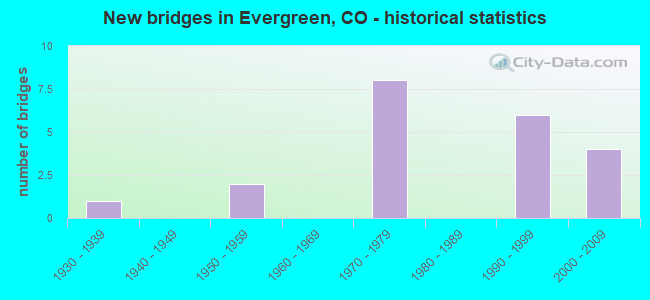
- New bridges - historical statistics
- 11930-1939
- 21950-1959
- 81970-1979
- 61990-1999
- 42000-2009


- Bridge Condition - Deck
- 53.3%Good
- 40.0%Satisfactory
- 6.7%Fair

- Bridge Condition - Superstructure
- 26.7%Very good
- 26.7%Good
- 26.7%Satisfactory
- 20.0%Fair

- Bridge Condition - Substructure
- 6.7%Very good
- 60.0%Good
- 20.0%Satisfactory
- 13.3%Fair

- Bridge Condition - Channel
- 46.7%Very good
- 33.3%Good
- 20.0%Satisfactory
Find on map >> Show street view
Structure Number: A-18-22A, Location: 2.6 MI W JCT EVERGRN LAKE (Lat: 39.642689, Lng: -105.366856), Route carried "on" structure: County highway , Year Built: 1992, Status: Open, Structure Length: 1.83m (6.00ft), Average Daily Traffic: 1,295 (year 2020), Truck Traffic: 4%, Average Future Daily Traffic: 1,490 (year 2040), Design Load: HS 20, Features Intersected: UPPER BEAR CREEK, Facility Carried by Structure: COUNTY ROAD 74
Minimum Vertical Clearance: 30+ m (98+ ft), Kilometerpoint: 2.974, Lanes on structure: 2, Owner: County Highway Agency, Approaching Roadway Width: 6.4m (21.0ft), Skew: 6 degrees, Material/Design: Steel, Design/Construction: Stringer/Multi-beam, Number Of Spans In Main Unit: 1, Length of Maximum Span: 15.2m (49.9ft), Curb-To-Curb Width: 8.5m (27.9ft), Out-to-Out Width: 8.8m (28.9ft)
Condition: Deck: Satisfactory, Superstructure: Fair, Substructure: Good, Channel: Satisfactory, Operating Rating: 43.9 metric tons, Method Used To Determine Operating Rating: Load Factor (LF), Inventory Rating: 26.3 metric tons, Method Used To Determine Inventory Rating: Load Factor (LF), Structural Evaluation: Somewhat better than minimum adequacy, Deck Geometry: Somewhat better than minimum adequacy, Waterway Adequacy: Equal to present minimum criteria, Approach Roadway Alignment: Equal to present desirable criteria, Designated Inspection Frequency: Every 24 months, Inspection Date: March 2021, Deck Structure Type: Corrugated Steel, Wearing Surface/Protective System: Wearing Surface: Bituminous
Find on map >> Show street view
Structure Number: A-18-23A, Location: 3 MI W JCT EVERGN LAKE (Lat: 39.640908, Lng: -105.374092), Route carried "on" structure: County highway , Year Built: 1992, Status: Open, Structure Length: 1.05m (3.44ft), Average Daily Traffic: 1,308 (year 2020), Truck Traffic: 4%, Average Future Daily Traffic: 1,504 (year 2040), Design Load: HS 20, Features Intersected: UPPER BEAR CREEK, Facility Carried by Structure: COUNTY ROAD 74
Minimum Vertical Clearance: 30+ m (98+ ft), Kilometerpoint: 2.292, Lanes on structure: 2, Owner: County Highway Agency, Approaching Roadway Width: 5.8m (19.0ft), Skew: 3 degrees, Material/Design: Steel, Design/Construction: Stringer/Multi-beam, Number Of Spans In Main Unit: 1, Length of Maximum Span: 8.0m (26.2ft), Curb-To-Curb Width: 7.3m (24.0ft), Out-to-Out Width: 7.6m (24.9ft)
Condition: Deck: Satisfactory, Superstructure: Fair, Substructure: Good, Channel: Very good, Operating Rating: 65.0 metric tons, Method Used To Determine Operating Rating: Load Factor (LF), Inventory Rating: 38.9 metric tons, Method Used To Determine Inventory Rating: Load Factor (LF), Structural Evaluation: Somewhat better than minimum adequacy, Deck Geometry: Meets minimum limits, Waterway Adequacy: Equal to present desirable criteria, Approach Roadway Alignment: Equal to present desirable criteria, Designated Inspection Frequency: Every 24 months, Inspection Date: March 2021, Deck Structure Type: Corrugated Steel, Wearing Surface/Protective System: Wearing Surface: Bituminous
Find on map >> Show street view
Structure Number: B-18-13, Location: JUST EAST OF CR 73 (Lat: 39.625242, Lng: -105.324567), Route carried "on" structure: County highway , Year Built: 1979, Status: Open, Structure Length: 0.94m (3.08ft), Average Daily Traffic: 1,089 (year 2021), Truck Traffic: 2%, Average Future Daily Traffic: 1,252 (year 2041), Design Load: HS 20, Features Intersected: CUB CREEK, Facility Carried by Structure: BUFFALO PARK ROAD
Minimum Vertical Clearance: 30+ m (98+ ft), Kilometerpoint: 13.192, Lanes on structure: 4, Owner: County Highway Agency, Approaching Roadway Width: 16.5m (54.1ft), Material/Design: Steel, Design/Construction: Stringer/Multi-beam, Number Of Spans In Main Unit: 1, Length of Maximum Span: 8.4m (27.6ft), Curb or Sidewalk Widths: Left: 1.3m (4.3ft), Right: 1.3m (4.3ft), Curb-To-Curb Width: 16.4m (53.8ft), Out-to-Out Width: 19.4m (63.6ft)
Condition: Deck: Good, Superstructure: Good, Substructure: Satisfactory, Channel: Good, Operating Rating: 66.2 metric tons, Method Used To Determine Operating Rating: Load Factor (LF), Inventory Rating: 39.7 metric tons, Method Used To Determine Inventory Rating: Load Factor (LF), Structural Evaluation: Equal to present minimum criteria, Deck Geometry: Meets minimum limits, Waterway Adequacy: Equal to present desirable criteria, Approach Roadway Alignment: Equal to present desirable criteria, Designated Inspection Frequency: Every 24 months, Inspection Date: March 2021, Deck Structure Type: Concrete Cast-file-Place, Wearing Surface/Protective System: Wearing Surface: Bituminous, Membrane: Built-up
Find on map >> Show street view
Structure Number: B-18-15A, Location: JUST SE OF SPILLWAY (Lat: 39.631092, Lng: -105.322156), Route carried "on" structure: County highway , Year Built: 2000, Status: Open, Structure Length: 0.67m (2.20ft), Average Daily Traffic: 15,760 (year 2021), Truck Traffic: 6%, Average Future Daily Traffic: 18,124 (year 2041), Features Intersected: CUB CREEK, Facility Carried by Structure: COUNTY ROAD 73
Minimum Vertical Clearance: 30+ m (98+ ft), Kilometerpoint: 14.014, Lanes on structure: 2, Owner: County Highway Agency, Approaching Roadway Width: 9.8m (32.2ft), Skew: 9 degrees, Material/Design: Concrete, Design/Construction: Frame, Number Of Spans In Main Unit: 1, Length of Maximum Span: 6.1m (20.0ft), Curb-To-Curb Width: 20.8m (68.2ft), Out-to-Out Width: 28.3m (92.8ft)
Condition: Deck: Good, Superstructure: Good, Substructure: Good, Channel: Good, Operating Rating: 80.4 metric tons, Method Used To Determine Operating Rating: Load Factor (LF), Inventory Rating: 48.3 metric tons, Method Used To Determine Inventory Rating: Load Factor (LF), Structural Evaluation: Better than present minimum criteria, Deck Geometry: Superior to present desirable criteria, Waterway Adequacy: Equal to present desirable criteria, Approach Roadway Alignment: Equal to present desirable criteria, Designated Inspection Frequency: Every 24 months, Inspection Date: March 2021, Deck Structure Type: Other, Wearing Surface/Protective System: Wearing Surface: Bituminous
Find on map >> Show street view
Structure Number: B-18-16A, Location: AT JCT W/ HWY 74 (Lat: 39.632389, Lng: -105.320842), Route carried "on" structure: County highway , Year Built: 2003, Status: Open, Structure Length: 1.34m (4.40ft), Average Daily Traffic: 15,760 (year 2021), Truck Traffic: 5%, Average Future Daily Traffic: 18,124 (year 2041), Design Load: HS 25 or greater, Features Intersected: BEAR CREEK, Facility Carried by Structure: COUNTY ROAD 73
Minimum Vertical Clearance: 30+ m (98+ ft), Kilometerpoint: 14.223, Lanes on structure: 5, Owner: County Highway Agency, Approaching Roadway Width: 9.8m (32.2ft), Skew: 30 degrees, Material/Design: Concrete, Design/Construction: Frame, Number Of Spans In Main Unit: 1, Length of Maximum Span: 12.2m (40.0ft), Curb or Sidewalk Widths: Left: 3.3m (10.8ft), Right: 1.9m (6.2ft), Curb-To-Curb Width: 21.8m (71.5ft), Out-to-Out Width: 32.9m (107.9ft)
Condition: Deck: Satisfactory, Superstructure: Satisfactory, Substructure: Satisfactory, Channel: Very good, Operating Rating: 77.1 metric tons, Method Used To Determine Operating Rating: Load Factor (LF), Inventory Rating: 46.3 metric tons, Method Used To Determine Inventory Rating: Load Factor (LF), Structural Evaluation: Equal to present minimum criteria, Deck Geometry: Somewhat better than minimum adequacy, Waterway Adequacy: Equal to present desirable criteria, Approach Roadway Alignment: Equal to present minimum criteria, Designated Inspection Frequency: Every 24 months, Inspection Date: March 2021, Deck Structure Type: Concrete Cast-file-Place, Wearing Surface/Protective System: Wearing Surface: Bituminous, Membrane: Built-up, Deck Protection: Epoxy Coated Reinforcing
Find on map >> Show street view
Structure Number: B-18-17, Location: FOREST HILL RD S HWY 74 (Lat: 39.633803, Lng: -105.316794), Route carried "on" structure: County highway , Year Built: 1975, Status: Open, Structure Length: 0.79m (2.59ft), Average Daily Traffic: 791 (year 2020), Truck Traffic: 2%, Average Future Daily Traffic: 909 (year 2040), Design Load: HS 20, Features Intersected: BEAR CREEK, Facility Carried by Structure: FOREST HILL RD
Minimum Vertical Clearance: 30+ m (98+ ft), Kilometerpoint: 2.442, Lanes on structure: 2, Owner: County Highway Agency, Approaching Roadway Width: 4.9m (16.1ft), Material/Design: Concrete, Design/Construction: Culvert, Number Of Spans In Main Unit: 2, Length of Maximum Span: 3.8m (12.5ft), Curb-To-Curb Width: 7.1m (23.3ft), Out-to-Out Width: 7.8m (25.6ft)
Condition: Channel: Satisfactory, Culverts: Satisfactory, Operating Rating: 36.3 metric tons, Method Used To Determine Operating Rating: Field evaluation and documented engineering judgment, Inventory Rating: 32.7 metric tons, Method Used To Determine Inventory Rating: Field evaluation and documented engineering judgment, Structural Evaluation: Equal to present minimum criteria, Deck Geometry: Meets minimum limits, Waterway Adequacy: Equal to present desirable criteria, Approach Roadway Alignment: Equal to present desirable criteria, Designated Inspection Frequency: Every 24 months, Inspection Date: March 2021, Deck Structure Type: Concrete Cast-file-Place, Wearing Surface/Protective System: Wearing Surface: Bituminous
Find on map >> Show street view
Structure Number: B-18-19, Location: S OF HWY 74 (Lat: 39.636258, Lng: -105.314922), Route carried "on" structure: County highway , Year Built: 1930, Status: Open, Structure Length: 0.96m (3.15ft), Average Daily Traffic: 407 (year 2021), Average Future Daily Traffic: 468 (year 2041), Features Intersected: BEAR CREEK, Facility Carried by Structure: INDEPENDENCE TRAIL
Minimum Vertical Clearance: 30+ m (98+ ft), Kilometerpoint: 0.010, Lanes on structure: 2, Owner: County Highway Agency, Approaching Roadway Width: 6.1m (20.0ft), Skew: 1 degrees, Material/Design: Concrete, Design/Construction: Tee Beam, Number Of Spans In Main Unit: 1, Length of Maximum Span: 9.3m (30.5ft), Curb-To-Curb Width: 6.2m (20.3ft), Out-to-Out Width: 6.6m (21.7ft)
Condition: Deck: Satisfactory, Superstructure: Fair, Substructure: Fair, Channel: Satisfactory, Operating Rating: 36.3 metric tons, Method Used To Determine Operating Rating: Field evaluation and documented engineering judgment, Inventory Rating: 32.7 metric tons, Method Used To Determine Inventory Rating: Field evaluation and documented engineering judgment, Structural Evaluation: Somewhat better than minimum adequacy, Deck Geometry: High priority of corrective action, Waterway Adequacy: Better than present minimum criteria, Approach Roadway Alignment: Equal to present desirable criteria, Designated Inspection Frequency: Every 24 months, Inspection Date: March 2021, Bridge Improvement Cost: $136,000, Roadway Improvement Cost: $14,000, Total Project Cost: $150,000 ( Estimate for 2015), Deck Structure Type: Concrete Cast-file-Place, Wearing Surface/Protective System: Wearing Surface: Bituminous
Find on map >> Show street view
Structure Number: B-18-20A, Location: .5MI W OF EVRGRN LAKE (Lat: 39.632992, Lng: -105.340478), Route carried "on" structure: County highway , Year Built: 2003, Status: Open, Structure Length: 1.56m (5.12ft), Average Daily Traffic: 1,624 (year 2020), Truck Traffic: 5%, Average Future Daily Traffic: 1,868 (year 2040), Design Load: HS 25 or greater, Features Intersected: UPPER BEAR CREEK, Facility Carried by Structure: COUNTY ROAD 74
Minimum Vertical Clearance: 30+ m (98+ ft), Kilometerpoint: 6.008, Lanes on structure: 2, Owner: County Highway Agency, Approaching Roadway Width: 7.0m (23.0ft), Skew: 4 degrees, Material/Design: Steel, Design/Construction: Stringer/Multi-beam, Number Of Spans In Main Unit: 1, Length of Maximum Span: 13.8m (45.3ft), Curb-To-Curb Width: 10.7m (35.1ft), Out-to-Out Width: 11.4m (37.4ft)
Condition: Deck: Good, Superstructure: Very good, Substructure: Good, Channel: Very good, Operating Rating: 83.9 metric tons, Method Used To Determine Operating Rating: Load Factor (LF), Inventory Rating: 50.3 metric tons, Method Used To Determine Inventory Rating: Load Factor (LF), Structural Evaluation: Better than present minimum criteria, Deck Geometry: Equal to present minimum criteria, Waterway Adequacy: Equal to present desirable criteria, Approach Roadway Alignment: Equal to present desirable criteria, Designated Inspection Frequency: Every 24 months, Inspection Date: March 2021, Deck Structure Type: Concrete Cast-file-Place, Wearing Surface/Protective System: Wearing Surface: Bituminous, Membrane: Built-up, Deck Protection: Epoxy Coated Reinforcing
Find on map >> Show street view
Structure Number: B-18-21A, Location: 1.4 MI W JCT EVRGN LAKE (Lat: 39.638600, Lng: -105.349742), Route carried "on" structure: County highway , Year Built: 1992, Status: Open, Structure Length: 0.84m (2.76ft), Average Daily Traffic: 1,436 (year 2020), Truck Traffic: 4%, Average Future Daily Traffic: 1,652 (year 2040), Design Load: HS 20, Features Intersected: UPPER BEAR CREEK, Facility Carried by Structure: COUNTY ROAD 74
Minimum Vertical Clearance: 30+ m (98+ ft), Kilometerpoint: 4.915, Lanes on structure: 2, Owner: County Highway Agency, Approaching Roadway Width: 6.4m (21.0ft), Skew: 3 degrees, Material/Design: Steel, Design/Construction: Stringer/Multi-beam, Number Of Spans In Main Unit: 1, Length of Maximum Span: 6.5m (21.3ft), Curb-To-Curb Width: 9.1m (29.9ft), Out-to-Out Width: 10.1m (33.1ft)
Condition: Deck: Good, Superstructure: Satisfactory, Substructure: Fair, Channel: Very good, Operating Rating: 85.5 metric tons, Method Used To Determine Operating Rating: Load Factor (LF), Inventory Rating: 51.3 metric tons, Method Used To Determine Inventory Rating: Load Factor (LF), Structural Evaluation: Somewhat better than minimum adequacy, Deck Geometry: Somewhat better than minimum adequacy, Waterway Adequacy: Equal to present desirable criteria, Approach Roadway Alignment: Equal to present desirable criteria, Designated Inspection Frequency: Every 24 months, Inspection Date: March 2021, Deck Structure Type: Concrete Cast-file-Place, Wearing Surface/Protective System: Wearing Surface: Bituminous
Find on map >> Show street view
Structure Number: B-18-95, Location: .1 M W OF LIl' CUB CK (Lat: 39.627778, Lng: -105.322331), Route carried "on" structure: County highway , Year Built: 1974, Status: Open, Structure Length: 0.70m (2.30ft), Average Daily Traffic: 326 (year 2020), Truck Traffic: 4%, Average Future Daily Traffic: 375 (year 2040), Features Intersected: LITTLE CUB CREEK, Facility Carried by Structure: SILVER SPRUCE LANE
Minimum Vertical Clearance: 30+ m (98+ ft), Kilometerpoint: 0.082, Lanes on structure: 2, Owner: County Highway Agency, Approaching Roadway Width: 9.8m (32.2ft), Skew: 2 degrees, Material/Design: Concrete, Design/Construction: Culvert, Number Of Spans In Main Unit: 2, Length of Maximum Span: 3.3m (10.8ft), Curb-To-Curb Width: 10.7m (35.1ft), Out-to-Out Width: 11.1m (36.4ft)
Condition: Channel: Good, Culverts: Satisfactory, Operating Rating: 36.3 metric tons, Method Used To Determine Operating Rating: Field evaluation and documented engineering judgment, Inventory Rating: 32.7 metric tons, Method Used To Determine Inventory Rating: Field evaluation and documented engineering judgment, Structural Evaluation: Equal to present minimum criteria, Deck Geometry: Better than present minimum criteria, Waterway Adequacy: Equal to present minimum criteria, Approach Roadway Alignment: Equal to present desirable criteria, Designated Inspection Frequency: Every 48 months, Inspection Date: Febuary 2019, Deck Structure Type: Concrete Cast-file-Place, Wearing Surface/Protective System: Wearing Surface: Bituminous
Find on map >> Show street view
Structure Number: F-15-AD, Location: 6.2 MI E OF JCT US 6 (Lat: 39.716447, Lng: -105.363733), Route carried "on" structure: US 40B, Year Built: 2000, Status: Open, Structure Length: 5.35m (17.55ft), Average Daily Traffic: 480 (year 2020), Truck Traffic: 3%, Average Future Daily Traffic: 706 (year 2040), Design Load: HS 25 or greater, Features Intersected: SODA CREEK, Facility Carried by Structure: US 40 ML
Minimum Vertical Clearance: 30+ m (98+ ft), Kilometerpoint: 7.669, Lanes on structure: 2, Owner: State Highway Agency, Approaching Roadway Width: 7.3m (24.0ft), Skew: 3 degrees, Material/Design: Steel, Design/Construction: Stringer/Multi-beam, Number Of Spans In Main Unit: 1, Length of Maximum Span: 51.8m (169.9ft), Curb-To-Curb Width: 9.1m (29.9ft), Out-to-Out Width: 10.1m (33.1ft)
Condition: Deck: Good, Superstructure: Very good, Substructure: Good, Channel: Very good, Operating Rating: 41.5 metric tons, Method Used To Determine Operating Rating: Load Factor (LF), Inventory Rating: 24.9 metric tons, Method Used To Determine Inventory Rating: Load Factor (LF), Structural Evaluation: Equal to present minimum criteria, Deck Geometry: Equal to present minimum criteria, Waterway Adequacy: Equal to present desirable criteria, Approach Roadway Alignment: Equal to present desirable criteria, Designated Inspection Frequency: Every 24 months, Inspection Date: August 2021, Deck Structure Type: Concrete Cast-file-Place, Wearing Surface/Protective System: Wearing Surface: Bituminous, Membrane: Built-up, Deck Protection: Epoxy Coated Reinforcing
Find on map >> Show street view
Structure Number: F-15-BD, Location: S.E. EDGE OF EVERGREEN (Lat: 39.636569, Lng: -105.315178), Route carried "on" structure: State highway 74A, Year Built: 1959, Status: Open, Structure Length: 1.07m (3.51ft), Average Daily Traffic: 6,000 (year 2020), Truck Traffic: 3%, Average Future Daily Traffic: 6,300 (year 2040), Design Load: HS 20, Features Intersected: BEAR CREEK, Facility Carried by Structure: SH 74 ML
Minimum Vertical Clearance: 30+ m (98+ ft), Kilometerpoint: 13.726, Lanes on structure: 2, Base Highway Network: Yes, Owner: State Highway Agency, Approaching Roadway Width: 9.1m (29.9ft), Skew: 4 degrees, Material/Design: Concrete, Design/Construction: Culvert, Number Of Spans In Main Unit: 2, Length of Maximum Span: 5.0m (16.4ft), Out-to-Out Width: 14.0m (45.9ft)
Condition: Channel: Good, Culverts: Satisfactory, Operating Rating: 36.3 metric tons, Method Used To Determine Operating Rating: Field evaluation and documented engineering judgment, Inventory Rating: 32.7 metric tons, Method Used To Determine Inventory Rating: Field evaluation and documented engineering judgment, Structural Evaluation: Equal to present minimum criteria, Waterway Adequacy: Equal to present desirable criteria, Approach Roadway Alignment: Equal to present desirable criteria, Designated Inspection Frequency: Every 24 months, Inspection Date: August 2021
Find on map >> Show street view
Structure Number: F-15-BE, Location: S.E.EDGE OF EVERGREEN (Lat: 39.637503, Lng: -105.313997), Route carried "on" structure: State highway 74A, Year Built: 1959, Status: Open, Structure Length: 1.08m (3.54ft), Average Daily Traffic: 6,000 (year 2020), Truck Traffic: 3%, Average Future Daily Traffic: 6,300 (year 2040), Design Load: HS 20, Features Intersected: BEAR CREEK, Facility Carried by Structure: SH 74 ML
Minimum Vertical Clearance: 30+ m (98+ ft), Kilometerpoint: 13.884, Lanes on structure: 2, Base Highway Network: Yes, Owner: State Highway Agency, Approaching Roadway Width: 9.1m (29.9ft), Skew: 4 degrees, Material/Design: Concrete, Design/Construction: Culvert, Number Of Spans In Main Unit: 2, Length of Maximum Span: 5.2m (17.1ft), Out-to-Out Width: 15.5m (50.9ft)
Condition: Channel: Good, Culverts: Satisfactory, Operating Rating: 36.3 metric tons, Method Used To Determine Operating Rating: Field evaluation and documented engineering judgment, Inventory Rating: 32.7 metric tons, Method Used To Determine Inventory Rating: Field evaluation and documented engineering judgment, Structural Evaluation: Equal to present minimum criteria, Waterway Adequacy: Equal to present desirable criteria, Approach Roadway Alignment: Equal to present desirable criteria, Designated Inspection Frequency: Every 24 months, Inspection Date: August 2021
Find on map >> Show street view
Structure Number: F-15-CC, Location: 6.4 MI E OF JCT US 6 (Lat: 39.712808, Lng: -105.366906), Route carried "on" structure: Interstate 70A, Year Built: 1971, Status: Open, Structure Length: 4.60m (15.09ft), Average Daily Traffic: 22,000 (year 2020), Truck Traffic: 7%, Average Future Daily Traffic: 28,600 (year 2040), Design Load: HS 20+Mod, Features Intersected: SODA CREEK ROAD, Facility Carried by Structure: I 70 ML EBND
Minimum Vertical Clearance: 30+ m (98+ ft), Kilometerpoint: 402.619, Lanes on structure: 3, Lanes under structure: 2, Base Highway Network: Yes, Owner: State Highway Agency, Approaching Roadway Width: 15.2m (49.9ft), Skew: 10 degrees, Material/Design: Concrete continuous, Design/Construction: Tee Beam, Number Of Spans In Main Unit: 3, Length of Maximum Span: 18.0m (59.1ft), Curb-To-Curb Width: 16.5m (54.1ft), Out-to-Out Width: 17.2m (56.4ft)
Condition: Deck: Satisfactory, Superstructure: Good, Substructure: Good, Operating Rating: 49.4 metric tons, Method Used To Determine Operating Rating: Load Factor (LF), Inventory Rating: 29.7 metric tons, Method Used To Determine Inventory Rating: Load Factor (LF), Structural Evaluation: Better than present minimum criteria, Deck Geometry: Equal to present minimum criteria, Underclear: Equal to present minimum criteria, Approach Roadway Alignment: Equal to present minimum criteria, Designated Inspection Frequency: Every 24 months, Inspection Date: December 2021, Deck Structure Type: Concrete Cast-file-Place, Wearing Surface/Protective System: Wearing Surface: Bituminous, Membrane: Built-up
Find on map >> Show street view
Structure Number: F-15-CD, Location: 2.4 MI W OF JCT SH 74 (Lat: 39.713000, Lng: -105.366750), Route carried "on" structure: Interstate 70A, Year Built: 1971, Status: Open, Structure Length: 4.18m (13.71ft), Average Daily Traffic: 22,000 (year 2020), Truck Traffic: 7%, Average Future Daily Traffic: 28,600 (year 2040), Design Load: HS 20+Mod, Features Intersected: SODA CREEK ROAD, Facility Carried by Structure: I 70 ML WBND
Minimum Vertical Clearance: 30+ m (98+ ft), Kilometerpoint: 402.621, Lanes on structure: 3, Lanes under structure: 2, Base Highway Network: Yes, Owner: State Highway Agency, Approaching Roadway Width: 15.5m (50.9ft), Skew: 10 degrees, Material/Design: Concrete continuous, Design/Construction: Tee Beam, Number Of Spans In Main Unit: 3, Length of Maximum Span: 18.0m (59.1ft), Curb-To-Curb Width: 16.5m (54.1ft), Out-to-Out Width: 17.2m (56.4ft)
Condition: Deck: Fair, Superstructure: Satisfactory, Substructure: Good, Operating Rating: 50.1 metric tons, Method Used To Determine Operating Rating: Load Factor (LF), Inventory Rating: 30.0 metric tons, Method Used To Determine Inventory Rating: Load Factor (LF), Structural Evaluation: Equal to present minimum criteria, Deck Geometry: Equal to present minimum criteria, Underclear: Somewhat better than minimum adequacy, Approach Roadway Alignment: Equal to present minimum criteria, Designated Inspection Frequency: Every 24 months, Inspection Date: December 2021, Deck Structure Type: Concrete Cast-file-Place, Wearing Surface/Protective System: Wearing Surface: Bituminous, Membrane: Preformed Fabric
Find on map >> Show street view
Structure Number: F-15-CE, Location: 8.1 MI E OF JCT US 6 (Lat: 39.703172, Lng: -105.338483), Route carried "on" structure: US 40B, Year Built: 1973, Status: Open, Structure Length: 7.68m (25.20ft), Average Daily Traffic: 480 (year 2020), Truck Traffic: 3%, Average Future Daily Traffic: 706 (year 2040), Design Load: HS 20+Mod, Features Intersected: I 70 ML, Facility Carried by Structure: US 40 ML
Minimum Vertical Clearance: 30+ m (98+ ft), Kilometerpoint: 10.931, Lanes on structure: 2, Lanes under structure: 6, Owner: State Highway Agency, Approaching Roadway Width: 11.3m (37.1ft), Material/Design: Steel continuous, Design/Construction: Stringer/Multi-beam, Number Of Spans In Main Unit: 2, Length of Maximum Span: 40.0m (131.2ft), Curb-To-Curb Width: 12.2m (40.0ft), Out-to-Out Width: 13.0m (42.7ft)
Condition: Deck: Satisfactory, Superstructure: Satisfactory, Substructure: Satisfactory, Operating Rating: 45.4 metric tons, Method Used To Determine Operating Rating: Load Factor (LF), Inventory Rating: 27.1 metric tons, Method Used To Determine Inventory Rating: Load Factor (LF), Structural Evaluation: Equal to present minimum criteria, Deck Geometry: Equal to present desirable criteria, Underclear: Better than present minimum criteria, Approach Roadway Alignment: Equal to present minimum criteria, Designated Inspection Frequency: Every 24 months, Inspection Date: August 2021, Deck Structure Type: Concrete Cast-file-Place, Wearing Surface/Protective System: Wearing Surface: Bituminous, Membrane: Preformed Fabric
Find on map >> Show street view
Structure Number: F-15-CZ, Location: S OF BERGEN PARK (Lat: 39.684050, Lng: -105.366392), Route carried "on" structure: State highway 74A, Year Built: 1995, Status: Open, Structure Length: 12.01m (39.40ft), Average Daily Traffic: 8,500 (year 2020), Truck Traffic: 4%, Average Future Daily Traffic: 8,755 (year 2040), Design Load: HS 20, Features Intersected: TROUBLESOME CREEK, Facility Carried by Structure: WBND SH 74 ML
Minimum Vertical Clearance: 30+ m (98+ ft), Kilometerpoint: 5.654, Lanes on structure: 2, Base Highway Network: Yes, Owner: State Highway Agency, Approaching Roadway Width: 11.6m (38.1ft), Skew: 1 degrees, Material/Design: Prestressed concrete continuous, Design/Construction: Stringer/Multi-beam, Number Of Spans In Main Unit: 3, Length of Maximum Span: 39.9m (130.9ft), Curb-To-Curb Width: 11.6m (38.1ft), Out-to-Out Width: 12.3m (40.4ft)
Condition: Deck: Good, Superstructure: Very good, Substructure: Very good, Channel: Very good, Operating Rating: 70.9 metric tons, Method Used To Determine Operating Rating: Load Factor (LF), Inventory Rating: 31.8 metric tons, Method Used To Determine Inventory Rating: Load Factor (LF), Structural Evaluation: Better than present minimum criteria, Deck Geometry: Better than present minimum criteria, Waterway Adequacy: Superior to present desirable criteria, Approach Roadway Alignment: Equal to present desirable criteria, Designated Inspection Frequency: Every 24 months, Inspection Date: August 2021, Deck Structure Type: Concrete Precast Panels, Wearing Surface/Protective System: Wearing Surface: Bituminous, Membrane: Preformed Fabric, Deck Protection: Epoxy Coated Reinforcing
Find on map >> Show street view
Structure Number: F-15-DA, Location: S OF BERGEN PARK (Lat: 39.684094, Lng: -105.366186), Route carried "on" structure: State highway 74A, Year Built: 1996, Status: Open, Structure Length: 12.01m (39.40ft), Average Daily Traffic: 8,500 (year 2020), Truck Traffic: 4%, Average Future Daily Traffic: 8,755 (year 2040), Design Load: HS 20, Features Intersected: TROUBLESOME CREEK, Facility Carried by Structure: SH 74 EBND
Minimum Vertical Clearance: 30+ m (98+ ft), Kilometerpoint: 5.650, Lanes on structure: 3, Base Highway Network: Yes, Owner: State Highway Agency, Approaching Roadway Width: 14.3m (46.9ft), Skew: 1 degrees, Material/Design: Prestressed concrete continuous, Design/Construction: Stringer/Multi-beam, Number Of Spans In Main Unit: 3, Length of Maximum Span: 39.9m (130.9ft), Curb-To-Curb Width: 13.4m (44.0ft), Out-to-Out Width: 14.1m (46.3ft)
Condition: Deck: Good, Superstructure: Very good, Substructure: Good, Channel: Very good, Operating Rating: 67.4 metric tons, Method Used To Determine Operating Rating: Load Factor (LF), Inventory Rating: 38.6 metric tons, Method Used To Determine Inventory Rating: Load Factor (LF), Structural Evaluation: Better than present minimum criteria, Deck Geometry: Somewhat better than minimum adequacy, Waterway Adequacy: Superior to present desirable criteria, Approach Roadway Alignment: Equal to present desirable criteria, Designated Inspection Frequency: Every 24 months, Inspection Date: August 2021, Deck Structure Type: Concrete Cast-file-Place, Wearing Surface/Protective System: Wearing Surface: Bituminous, Membrane: Preformed Fabric, Deck Protection: Epoxy Coated Reinforcing
Find on map >> Show street view
Structure Number: F-15-DB, Location: NEAR BERGEN PARK (Lat: 39.694014, Lng: -105.352747), Route carried "on" structure: State highway 74A, Year Built: 1996, Status: Open, Structure Length: 1.02m (3.35ft), Average Daily Traffic: 18,000 (year 2020), Truck Traffic: 4%, Average Future Daily Traffic: 18,900 (year 2040), Design Load: HS 20, Features Intersected: GAME CROSSING, Facility Carried by Structure: SH 74 ML
Minimum Vertical Clearance: 30+ m (98+ ft), Kilometerpoint: 3.658, Lanes on structure: 4, Base Highway Network: Yes, Owner: State Highway Agency, Approaching Roadway Width: 21.9m (71.9ft), Skew: 20 degrees, Material/Design: Concrete, Design/Construction: Slab, Number Of Spans In Main Unit: 1, Length of Maximum Span: 9.1m (29.9ft), Curb-To-Curb Width: 26.2m (86.0ft), Out-to-Out Width: 27.0m (88.6ft)
Condition: Deck: Good, Superstructure: Good, Substructure: Good, Operating Rating: 89.8 metric tons, Method Used To Determine Operating Rating: Field evaluation and documented engineering judgment, Inventory Rating: 89.8 metric tons, Method Used To Determine Inventory Rating: Field evaluation and documented engineering judgment, Structural Evaluation: Better than present minimum criteria, Deck Geometry: Superior to present desirable criteria, Approach Roadway Alignment: Equal to present desirable criteria, Designated Inspection Frequency: Every 48 months, Inspection Date: August 2019, Deck Structure Type: Concrete Cast-file-Place, Wearing Surface/Protective System: Wearing Surface: Bituminous
Find on map >> Show street view
Structure Number: F-15-CD, Location: 2.4 MI W OF JCT SH 74 (Lat: 39.713000, Lng: -105.366750), Route carried "under" structure: City street , Year Built: 1971, Structure Length: 0. m, Average Daily Traffic: 1,000 (year 2017), Truck Traffic: 1%, Features Intersected: SODA CREEK ROAD, Facility Carried by Structure: I 70 ML WBND
Minimum Vertical Clearance: 4.88m (16.01ft), Kilometerpoint: 0.000, Lanes on structure: 3, Lanes under structure: 2, Material/Design: Concrete continuous, Design/Construction: Tee Beam, Length of Maximum Span: 18.0m (59.1ft)
Find on map >> Show street view
Structure Number: F-15-CE, Location: 8.1 MI E OF JCT US 6 (Lat: 39.703172, Lng: -105.338483), Route carried "under" structure: Interstate 70A, Year Built: 1973, Structure Length: 0. m, Average Daily Traffic: 47,000 (year 2011), Truck Traffic: 8%, Features Intersected: I 70 ML, Facility Carried by Structure: US 40 ML
Minimum Vertical Clearance: 7.16m (23.49ft), Kilometerpoint: 403.487, Lanes on structure: 2, Lanes under structure: 6, Material/Design: Steel continuous, Design/Construction: Stringer/Multi-beam, Length of Maximum Span: 40.0m (131.2ft)