Bridge Statistics for Estero, Florida (FL)
Condition, Traffic, Stress, Structural Evaluation, Project Costs
- National Bridge Inventory (NBI) Statistics
- 18Number of bridges
- 131ft / 40.1mTotal length
- 767,930Total average daily traffic
- 77,384Total average daily truck traffic
- National Bridge Inventory (NBI) Registered Bridges for Estero
- No street view available for this location
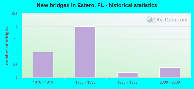
- New bridges - historical statistics
- 51970-1979
- 101980-1989
- 11990-1999
- 22000-2009

- Reconstructed bridges - Historical Statistics
- 42000-2009
- 22010-2019


- Bridge Condition - Substructure
- 25.0%Very good
- 75.0%Good

- Bridge Condition - Channel
- 81.8%Good
- 18.2%Satisfactory

- Bridge Condition - Culverts
- 57.1%Good
- 42.9%Satisfactory
Find on map >> Show street view
Structure Number: 12013, Location: 0.75mi. S of CORKSCREW RD (Lat: 26.421494, Lng: -81.774117), Route carried "on" structure: Interstate 75, Year Built: 1979, Status: Open, Structure Length: 3.66m (12.01ft), Average Daily Traffic: 55,000 (year 2021), Truck Traffic: 11%, Average Future Daily Traffic: 95,425 (year 2041), Design Load: HS 20, Features Intersected: MONTY RUN
Minimum Vertical Clearance: 30+ m (98+ ft), Kilometerpoint: 12.200, Lanes on structure: 3, Base Highway Network: Yes, Owner: State Highway Agency, Approaching Roadway Width: 17.2m (56.4ft), Material/Design: Concrete continuous, Design/Construction: Slab, Number Of Spans In Main Unit: 4, Length of Maximum Span: 9.1m (29.9ft), Curb-To-Curb Width: 17.2m (56.4ft), Out-to-Out Width: 18.0m (59.1ft)
Condition: Deck: Good, Superstructure: Good, Substructure: Good, Channel: Good, Operating Rating: 57.2 metric tons, Method Used To Determine Operating Rating: Load Factor (LF), Inventory Rating: 34.3 metric tons, Method Used To Determine Inventory Rating: Load Factor (LF), Structural Evaluation: Better than present minimum criteria, Deck Geometry: Better than present minimum criteria, Waterway Adequacy: Equal to present desirable criteria, Approach Roadway Alignment: Equal to present desirable criteria, Designated Inspection Frequency: Every 24 months, Inspection Date: April 2021, Deck Structure Type: Concrete Cast-file-Place
Find on map >> Show street view
Structure Number: 120131, Location: 0.75mi. S of CORKSCREW RD (Lat: 26.421539, Lng: -81.773781), Route carried "on" structure: Interstate 75, Year Built: 1979, Year Reconstructed: 2009, Status: Open, Structure Length: 3.66m (12.01ft), Average Daily Traffic: 55,000 (year 2021), Truck Traffic: 11%, Average Future Daily Traffic: 95,425 (year 2041), Design Load: HS 20, Features Intersected: MONTY RUN
Minimum Vertical Clearance: 30+ m (98+ ft), Kilometerpoint: 12.200, Lanes on structure: 3, Base Highway Network: Yes, Owner: State Highway Agency, Approaching Roadway Width: 17.2m (56.4ft), Material/Design: Concrete continuous, Design/Construction: Slab, Number Of Spans In Main Unit: 4, Length of Maximum Span: 9.2m (30.2ft), Curb-To-Curb Width: 17.2m (56.4ft), Out-to-Out Width: 18.0m (59.1ft)
Condition: Deck: Good, Superstructure: Good, Substructure: Good, Channel: Good, Operating Rating: 57.2 metric tons, Method Used To Determine Operating Rating: Load Factor (LF), Inventory Rating: 34.3 metric tons, Method Used To Determine Inventory Rating: Load Factor (LF), Structural Evaluation: Better than present minimum criteria, Deck Geometry: Better than present minimum criteria, Waterway Adequacy: Equal to present desirable criteria, Approach Roadway Alignment: Equal to present desirable criteria, Designated Inspection Frequency: Every 24 months, Inspection Date: April 2021, Deck Structure Type: Concrete Cast-file-Place
Find on map >> Show street view
Structure Number: 12014, Location: 8.3 MI N OF COLLIER CO (Lat: 26.432269, Lng: -81.778039), Route carried "on" structure: Interstate 75, Year Built: 1981, Year Reconstructed: 2010, Status: Open, Structure Length: 6.77m (22.21ft), Average Daily Traffic: 55,000 (year 2021), Truck Traffic: 11%, Average Future Daily Traffic: 95,425 (year 2041), Design Load: HL 93, Features Intersected: CORKSCREW RD (CR-850)
Minimum Vertical Clearance: 30+ m (98+ ft), Kilometerpoint: 13.443, Lanes on structure: 3, Lanes under structure: 8, Base Highway Network: Yes, Owner: State Highway Agency, Approaching Roadway Width: 16.5m (54.1ft), Skew: 1 degrees, Material/Design: Prestressed concrete continuous, Design/Construction: Stringer/Multi-beam, Number Of Spans In Main Unit: 2, Length of Maximum Span: 33.8m (110.9ft), Curb-To-Curb Width: 16.5m (54.1ft), Out-to-Out Width: 18.0m (59.1ft)
Condition: Deck: Good, Superstructure: Good, Substructure: Very good, Operating Rating: 40.2 metric tons, Method Used To Determine Operating Rating: Load and Resistance Factor (LRFR), Inventory Rating: 33.7 metric tons, Method Used To Determine Inventory Rating: Load and Resistance Factor (LRFR), Structural Evaluation: Better than present minimum criteria, Deck Geometry: Equal to present minimum criteria, Underclear: Better than present minimum criteria, Approach Roadway Alignment: Equal to present desirable criteria, Designated Inspection Frequency: Every 24 months, Inspection Date: April 2021, Deck Structure Type: Concrete Cast-file-Place
Find on map >> Show street view
Structure Number: 120141, Location: 8.3 MI N OF COLLIER CO (Lat: 26.432406, Lng: -81.777736), Route carried "on" structure: Interstate 75, Year Built: 1981, Year Reconstructed: 2010, Status: Open, Structure Length: 6.77m (22.21ft), Average Daily Traffic: 55,000 (year 2021), Truck Traffic: 11%, Average Future Daily Traffic: 95,425 (year 2041), Design Load: HL 93, Features Intersected: CORKSCREW ROAD (CR-850)
Minimum Vertical Clearance: 30.45m (99.90ft), Kilometerpoint: 13.449, Lanes on structure: 3, Lanes under structure: 6, Base Highway Network: Yes, Owner: State Highway Agency, Approaching Roadway Width: 16.5m (54.1ft), Skew: 1 degrees, Material/Design: Prestressed concrete continuous, Design/Construction: Stringer/Multi-beam, Number Of Spans In Main Unit: 2, Length of Maximum Span: 33.8m (110.9ft), Curb-To-Curb Width: 16.5m (54.1ft), Out-to-Out Width: 18.0m (59.1ft)
Condition: Deck: Good, Superstructure: Good, Substructure: Very good, Operating Rating: 40.2 metric tons, Method Used To Determine Operating Rating: Load and Resistance Factor (LRFR), Inventory Rating: 33.7 metric tons, Method Used To Determine Inventory Rating: Load and Resistance Factor (LRFR), Structural Evaluation: Better than present minimum criteria, Deck Geometry: Equal to present minimum criteria, Underclear: Better than present minimum criteria, Approach Roadway Alignment: Equal to present desirable criteria, Designated Inspection Frequency: Every 24 months, Inspection Date: April 2021, Deck Structure Type: Concrete Cast-file-Place
Find on map >> Show street view
Structure Number: 120149, Location: 1.0 mi. S OF CORKSCREW RD (Lat: 26.417400, Lng: -81.773608), Route carried "on" structure: Interstate 75, Year Built: 1980, Year Reconstructed: 2009, Status: Open, Structure Length: 0.79m (2.59ft), Average Daily Traffic: 55,000 (year 2021), Truck Traffic: 11%, Average Future Daily Traffic: 95,425 (year 2041), Design Load: HL 93, Features Intersected: STOKES HEAD SLOUGH
Minimum Vertical Clearance: 30.45m (99.90ft), Kilometerpoint: 11.761, Lanes on structure: 3, Base Highway Network: Yes, Owner: State Highway Agency, Approaching Roadway Width: 17.5m (57.4ft), Material/Design: Concrete, Design/Construction: Culvert, Number Of Spans In Main Unit: 3, Length of Maximum Span: 2.7m (8.9ft)
Condition: Channel: Good, Culverts: Good, Operating Rating: 49.9 metric tons, Method Used To Determine Operating Rating: Load and Resistance Factor (LRFR), Inventory Rating: 38.1 metric tons, Method Used To Determine Inventory Rating: Load and Resistance Factor (LRFR), Structural Evaluation: Better than present minimum criteria, Waterway Adequacy: Equal to present desirable criteria, Approach Roadway Alignment: Equal to present desirable criteria, Designated Inspection Frequency: Every 24 months, Underwater Inspection Frequency: Every 24 months, Inspection Date: April 2021, Underwater Inspection Date: March 2021
Find on map >> Show street view
Structure Number: 120151, Location: 1.0 mi. S OF CORKSCREW RD (Lat: 26.417417, Lng: -81.773056), Route carried "on" structure: Interstate 75, Year Built: 1980, Status: Open, Structure Length: 0.79m (2.59ft), Average Daily Traffic: 55,000 (year 2021), Truck Traffic: 11%, Average Future Daily Traffic: 95,425 (year 2041), Design Load: HL 93, Features Intersected: STOKES HEAD SLOUGH
Minimum Vertical Clearance: 30.45m (99.90ft), Kilometerpoint: 11.761, Lanes on structure: 3, Base Highway Network: Yes, Owner: State Highway Agency, Approaching Roadway Width: 17.3m (56.8ft), Material/Design: Concrete, Design/Construction: Culvert, Number Of Spans In Main Unit: 3, Length of Maximum Span: 2.7m (8.9ft)
Condition: Channel: Good, Culverts: Satisfactory, Operating Rating: 47.2 metric tons, Method Used To Determine Operating Rating: Load and Resistance Factor (LRFR), Inventory Rating: 36.3 metric tons, Method Used To Determine Inventory Rating: Load and Resistance Factor (LRFR), Structural Evaluation: Equal to present minimum criteria, Waterway Adequacy: Equal to present desirable criteria, Approach Roadway Alignment: Equal to present desirable criteria, Designated Inspection Frequency: Every 24 months, Underwater Inspection Frequency: Every 24 months, Inspection Date: April 2021, Underwater Inspection Date: March 2021
Find on map >> Show street view
Structure Number: 120152, Location: 0.5MI. N OF CORKSCREW RD. (Lat: 26.438522, Lng: -81.780111), Route carried "on" structure: Interstate 75, Year Built: 1979, Status: Open, Structure Length: 0.76m (2.49ft), Average Daily Traffic: 109,000 (year 2021), Truck Traffic: 11%, Average Future Daily Traffic: 189,115 (year 2041), Design Load: HS 20+Mod, Features Intersected: CORKSCREW CANAL
Minimum Vertical Clearance: 30+ m (98+ ft), Kilometerpoint: 14.198, Lanes on structure: 6, Base Highway Network: Yes, Owner: State Highway Agency, Approaching Roadway Width: 35.8m (117.5ft), Material/Design: Concrete, Design/Construction: Culvert, Number Of Spans In Main Unit: 2, Length of Maximum Span: 3.8m (12.5ft)
Condition: Channel: Good, Culverts: Satisfactory, Inventory Rating: 71.6 metric tons, Method Used To Determine Inventory Rating: Load Factor (LF), Structural Evaluation: Equal to present minimum criteria, Waterway Adequacy: Equal to present desirable criteria, Approach Roadway Alignment: Equal to present desirable criteria, Designated Inspection Frequency: Every 24 months, Underwater Inspection Frequency: Every 24 months, Inspection Date: May 2021, Underwater Inspection Date: April 2021
Find on map >> Show street view
Structure Number: 120153, Location: 1MI. N OF CORKSCREW RD (Lat: 26.445528, Lng: -81.782661), Route carried "on" structure: Interstate 75, Year Built: 1979, Status: Open, Structure Length: 0.75m (2.46ft), Average Daily Traffic: 109,000 (year 2021), Truck Traffic: 11%, Average Future Daily Traffic: 189,115 (year 2041), Design Load: HS 20+Mod, Features Intersected: HICKS CROSSING CANAL
Minimum Vertical Clearance: 30+ m (98+ ft), Kilometerpoint: 15.014, Lanes on structure: 6, Base Highway Network: Yes, Owner: State Highway Agency, Approaching Roadway Width: 34.8m (114.2ft), Skew: 20 degrees, Material/Design: Concrete, Design/Construction: Culvert, Number Of Spans In Main Unit: 2, Length of Maximum Span: 3.7m (12.1ft)
Condition: Channel: Good, Culverts: Good, Inventory Rating: 72.4 metric tons, Method Used To Determine Inventory Rating: Load Factor (LF), Structural Evaluation: Better than present minimum criteria, Waterway Adequacy: Equal to present desirable criteria, Approach Roadway Alignment: Equal to present desirable criteria, Designated Inspection Frequency: Every 24 months, Inspection Date: May 2021
Find on map >> Show street view
Structure Number: 120154, Location: 0.25MI N/O CORKSCREW RD (Lat: 26.434889, Lng: -81.810806), Route carried "on" structure: US 41, Year Built: 1982, Year Reconstructed: 2013, Status: Open, Structure Length: 4.57m (14.99ft), Average Daily Traffic: 40,000 (year 2020), Truck Traffic: 5%, Average Future Daily Traffic: 69,400 (year 2042), Design Load: HL 93, Features Intersected: ESTERO RIVER
Minimum Vertical Clearance: 30+ m (98+ ft), Kilometerpoint: 13.160, Lanes on structure: 6, Base Highway Network: Yes, Owner: State Highway Agency, Approaching Roadway Width: 25.1m (82.3ft), Skew: 22 degrees, Material/Design: Concrete continuous, Design/Construction: Slab, Number Of Spans In Main Unit: 5, Length of Maximum Span: 9.1m (29.9ft), Curb or Sidewalk Widths: Left: 1.8m (5.9ft), Right: 1.8m (5.9ft), Curb-To-Curb Width: 25.1m (82.3ft), Out-to-Out Width: 34.0m (111.5ft)
Condition: Deck: Good, Superstructure: Good, Substructure: Good, Channel: Good, Operating Rating: 52.6 metric tons, Method Used To Determine Operating Rating: Load and Resistance Factor (LRFR), Inventory Rating: 40.8 metric tons, Method Used To Determine Inventory Rating: Load and Resistance Factor (LRFR), Structural Evaluation: Better than present minimum criteria, Deck Geometry: Somewhat better than minimum adequacy, Waterway Adequacy: Equal to present desirable criteria, Approach Roadway Alignment: Equal to present desirable criteria, Designated Inspection Frequency: Every 24 months, Underwater Inspection Frequency: Every 24 months, Inspection Date: July 2020, Underwater Inspection Date: June 2020, Deck Structure Type: Concrete Cast-file-Place
Find on map >> Show street view
Structure Number: 120155, Location: 1.5MI S OF CORKSCREW RD (Lat: 26.409389, Lng: -81.811583), Route carried "on" structure: US 41, Year Built: 1982, Status: Open, Structure Length: 0.96m (3.15ft), Average Daily Traffic: 42,500 (year 2020), Truck Traffic: 6%, Average Future Daily Traffic: 73,738 (year 2042), Design Load: HS 20+Mod, Features Intersected: HALFWAY CREEK
Minimum Vertical Clearance: 30+ m (98+ ft), Kilometerpoint: 10.348, Lanes on structure: 6, Base Highway Network: Yes, Owner: State Highway Agency, Approaching Roadway Width: 28.2m (92.5ft), Skew: 10 degrees, Material/Design: Concrete, Design/Construction: Culvert, Number Of Spans In Main Unit: 3, Length of Maximum Span: 3.4m (11.2ft)
Condition: Channel: Good, Culverts: Satisfactory, Operating Rating: 86.3 metric tons, Method Used To Determine Operating Rating: Load Factor (LF), Inventory Rating: 51.7 metric tons, Method Used To Determine Inventory Rating: Load Factor (LF), Structural Evaluation: Equal to present minimum criteria, Waterway Adequacy: Equal to present desirable criteria, Approach Roadway Alignment: Equal to present desirable criteria, Designated Inspection Frequency: Every 24 months, Underwater Inspection Frequency: Every 24 months, Inspection Date: July 2020, Underwater Inspection Date: June 2020
Find on map >> Show street view
Structure Number: 124008, Location: 0.2 MI N of CORKSCREW RD (Lat: 26.434714, Lng: -81.804944), Route carried "on" structure: County highway , Year Built: 1976, Status: Open, Structure Length: 2.13m (6.99ft), Average Daily Traffic: 1,030 (year 2021), Truck Traffic: 2%, Average Future Daily Traffic: 1,082 (year 2041), Features Intersected: ESTERO RIVER, Facility Carried by Structure: SANDY LANE
Minimum Vertical Clearance: 30+ m (98+ ft), Kilometerpoint: 0.369, Lanes on structure: 2, Owner: City or Municipal Highway Agency, Approaching Roadway Width: 7.5m (24.6ft), Material/Design: Prestressed concrete, Design/Construction: Slab, Number Of Spans In Main Unit: 3, Length of Maximum Span: 12.2m (40.0ft), Curb or Sidewalk Widths: Left: 0.6m (2.0ft), Right: 0.6m (2.0ft), Curb-To-Curb Width: 8.6m (28.2ft), Out-to-Out Width: 10.3m (33.8ft)
Condition: Deck: Good, Superstructure: Good, Substructure: Good, Channel: Satisfactory, Operating Rating: 68.0 metric tons, Method Used To Determine Operating Rating: Load Factor (LF), Inventory Rating: 40.8 metric tons, Method Used To Determine Inventory Rating: Load Factor (LF), Structural Evaluation: Better than present minimum criteria, Deck Geometry: Somewhat better than minimum adequacy, Waterway Adequacy: Better than present minimum criteria, Approach Roadway Alignment: Equal to present desirable criteria, Designated Inspection Frequency: Every 24 months, Underwater Inspection Frequency: Every 24 months, Inspection Date: August 2021, Underwater Inspection Date: July 2021, Deck Structure Type: Concrete Precast Panels, Wearing Surface/Protective System: Wearing Surface: Bituminous
Find on map >> Show street view
Structure Number: 124067, Location: 0.9 MI N OF CORKSCREW RD (Lat: 26.445006, Lng: -81.788747), Route carried "on" structure: County highway , Year Built: 1988, Year Reconstructed: 2006, Status: Open, Structure Length: 1.37m (4.49ft), Average Daily Traffic: 13,900 (year 2021), Truck Traffic: 5%, Average Future Daily Traffic: 17,375 (year 2041), Design Load: HS 25 or greater, Features Intersected: Drainage Ditch, Facility Carried by Structure: THREE OAKS PKWY
Minimum Vertical Clearance: 30+ m (98+ ft), Kilometerpoint: 3.103, Lanes on structure: 5, Owner: County Highway Agency, Approaching Roadway Width: 16.8m (55.1ft), Skew: 10 degrees, Material/Design: Concrete, Design/Construction: Culvert, Number Of Spans In Main Unit: 4, Length of Maximum Span: 3.0m (9.8ft), Curb or Sidewalk Widths: Left: 1.8m (5.9ft), Right: 1.8m (5.9ft)
Condition: Channel: Satisfactory, Culverts: Good, Operating Rating: 64.0 metric tons, Method Used To Determine Operating Rating: Load and Resistance Factor (LRFR), Inventory Rating: 49.3 metric tons, Method Used To Determine Inventory Rating: Load and Resistance Factor (LRFR), Structural Evaluation: Better than present minimum criteria, Waterway Adequacy: Equal to present minimum criteria, Approach Roadway Alignment: Equal to present desirable criteria, Designated Inspection Frequency: Every 24 months, Underwater Inspection Frequency: Every 23 months, Inspection Date: March 2021, Underwater Inspection Date: March 2021
Find on map >> Show street view
Structure Number: 124068, Location: 1.0 MI N OF CORKSCREW RD (Lat: 26.446431, Lng: -81.788789), Route carried "on" structure: County highway , Year Built: 1988, Status: Open, Structure Length: 0.88m (2.89ft), Average Daily Traffic: 13,900 (year 2021), Truck Traffic: 5%, Average Future Daily Traffic: 17,375 (year 2041), Design Load: HL 93, Features Intersected: LORI'S DITCH, Facility Carried by Structure: THREE OAKS PKWY
Minimum Vertical Clearance: 30.45m (99.90ft), Kilometerpoint: 0.000, Lanes on structure: 4, Owner: County Highway Agency, Approaching Roadway Width: 13.8m (45.3ft), Material/Design: Concrete, Design/Construction: Culvert, Number Of Spans In Main Unit: 3, Length of Maximum Span: 2.9m (9.5ft)
Condition: Channel: Good, Culverts: Good, Operating Rating: 46.4 metric tons, Method Used To Determine Operating Rating: Load Factor (LF), Inventory Rating: 27.8 metric tons, Method Used To Determine Inventory Rating: Load Factor (LF), Structural Evaluation: Equal to present minimum criteria, Waterway Adequacy: Better than present minimum criteria, Approach Roadway Alignment: Equal to present desirable criteria, Designated Inspection Frequency: Every 24 months, Underwater Inspection Frequency: Every 24 months, Inspection Date: March 2021, Underwater Inspection Date: Febuary 2021
Find on map >> Show street view
Structure Number: 124087, Location: 5.0 mi. E of I-75 (Lat: 26.453275, Lng: -81.699636), Route carried "on" structure: County highway , Year Built: 1994, Status: Open, Structure Length: 3.70m (12.14ft), Average Daily Traffic: 3,600 (year 2021), Truck Traffic: 25%, Average Future Daily Traffic: 4,500 (year 2041), Design Load: HS 20, Features Intersected: WILDLIFE UNDERPASS, Facility Carried by Structure: CORKSCREW ROAD
Minimum Vertical Clearance: 30.45m (99.90ft), Kilometerpoint: 8.336, Lanes on structure: 2, Owner: County Highway Agency, Approaching Roadway Width: 11.0m (36.1ft), Material/Design: Concrete continuous, Design/Construction: Slab, Number Of Spans In Main Unit: 4, Length of Maximum Span: 9.8m (32.2ft), Curb-To-Curb Width: 11.0m (36.1ft), Out-to-Out Width: 11.9m (39.0ft)
Condition: Deck: Good, Superstructure: Good, Substructure: Good, Operating Rating: 57.4 metric tons, Method Used To Determine Operating Rating: Load Factor (LF), Inventory Rating: 34.3 metric tons, Method Used To Determine Inventory Rating: Load Factor (LF), Structural Evaluation: Better than present minimum criteria, Deck Geometry: Somewhat better than minimum adequacy, Approach Roadway Alignment: Equal to present desirable criteria, Designated Inspection Frequency: Every 24 months, Inspection Date: March 2021, Deck Structure Type: Concrete Cast-file-Place
Find on map >> Show street view
Structure Number: 124135, Location: 1.5MI EAST OF US 41 (Lat: 26.413086, Lng: -81.785631), Route carried "on" structure: County highway , Year Built: 2001, Status: Open, Structure Length: 2.51m (8.23ft), Average Daily Traffic: 13,000 (year 2021), Truck Traffic: 1%, Average Future Daily Traffic: 15,600 (year 2041), Design Load: HS 20, Features Intersected: Oakwilde Blvd., Facility Carried by Structure: Three Oaks Parkway
Minimum Vertical Clearance: 30+ m (98+ ft), Kilometerpoint: 12.461, Lanes on structure: 4, Lanes under structure: 4, Owner: County Highway Agency, Approaching Roadway Width: 17.4m (57.1ft), Skew: 30 degrees, Material/Design: Concrete, Design/Construction: Arch - Deck, Number Of Spans In Main Unit: 2, Length of Maximum Span: 12.7m (41.7ft), Curb or Sidewalk Widths: Left: 3.7m (12.1ft), Right: 3.7m (12.1ft), Curb-To-Curb Width: 17.4m (57.1ft), Out-to-Out Width: 18.3m (60.0ft)
Condition: Superstructure: Good, Substructure: Good, Operating Rating: 73.7 metric tons, Method Used To Determine Operating Rating: Load and Resistance Factor (LRFR), Inventory Rating: 56.8 metric tons, Method Used To Determine Inventory Rating: Load and Resistance Factor (LRFR), Structural Evaluation: Better than present minimum criteria, Deck Geometry: Somewhat better than minimum adequacy, Underclear: High priority of corrective action, Approach Roadway Alignment: Equal to present desirable criteria, Designated Inspection Frequency: Every 24 months, Inspection Date: December 2021
Find on map >> Show street view
Structure Number: 12014, Location: 8.3 MI N OF COLLIER CO (Lat: 26.432269, Lng: -81.778039), Route carried "under" structure: County highway 850, Year Built: 1981, Structure Length: 0. m, Average Daily Traffic: 45,750 (year 2021), Truck Traffic: 11%, Features Intersected: CORKSCREW RD (CR-850), Facility Carried by Structure: I-75 SB (SR-93)
Minimum Vertical Clearance: 5.03m (16.50ft), Kilometerpoint: 0.000, Lanes on structure: 3, Lanes under structure: 8, Material/Design: Prestressed concrete continuous, Design/Construction: Stringer/Multi-beam, Length of Maximum Span: 33.8m (110.9ft)
Find on map >> Show street view
Structure Number: 120141, Location: 8.3 MI N OF COLLIER CO (Lat: 26.432406, Lng: -81.777736), Route carried "under" structure: County highway 850, Year Built: 1981, Structure Length: 0. m, Average Daily Traffic: 45,750 (year 2021), Truck Traffic: 11%, Features Intersected: CORKSCREW ROAD (CR-850), Facility Carried by Structure: I-75 NB (SR-93)
Minimum Vertical Clearance: 5.21m (17.09ft), Kilometerpoint: 0.000, Lanes on structure: 3, Lanes under structure: 6, Material/Design: Prestressed concrete continuous, Design/Construction: Stringer/Multi-beam, Length of Maximum Span: 33.8m (110.9ft)
Find on map >> Show street view
Structure Number: 124135, Location: 1.5MI EAST OF US 41 (Lat: 26.413086, Lng: -81.785631), Route carried "under" structure: City street , Year Built: 2001, Structure Length: 0. m, Average Daily Traffic: 500 (year 2021), Truck Traffic: 10%, Features Intersected: Oakwilde Blvd., Facility Carried by Structure: Three Oaks Parkway
Minimum Vertical Clearance: 4.15m (13.62ft), Kilometerpoint: 0.000, Lanes on structure: 4, Lanes under structure: 2, Material/Design: Concrete, Design/Construction: Arch - Deck, Length of Maximum Span: 12.7m (41.7ft)