Bridge Statistics for Essex, Maryland (MD)
Condition, Traffic, Stress, Structural Evaluation, Project Costs
- National Bridge Inventory (NBI) Statistics
- 22Number of bridges
- 407ft / 124mTotal length
- $99,999,000Total costs
- 515,938Total average daily traffic
- 25,345Total average daily truck traffic
- National Bridge Inventory (NBI) Registered Bridges for Essex
- No street view available for this location
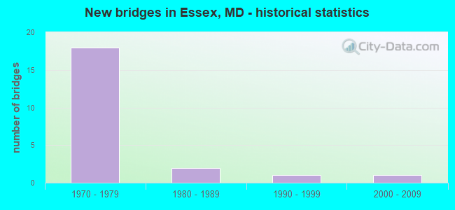
- New bridges - historical statistics
- 181970-1979
- 21980-1989
- 11990-1999
- 12000-2009

- Reconstructed bridges - Historical Statistics
- 11960-1969
- 01970-1979
- 11980-1989
- 01990-1999
- 32000-2009


- Bridge Condition - Deck
- 7.7%Very good
- 61.5%Good
- 30.8%Satisfactory

- Bridge Condition - Superstructure
- 30.8%Good
- 69.2%Satisfactory

- Bridge Condition - Substructure
- 30.8%Good
- 69.2%Satisfactory

- Bridge Condition - Channel
- 28.6%Very good
- 42.9%Good
- 28.6%Satisfactory

- Bridge Condition - Culverts
- 50.0%Good
- 50.0%Satisfactory
Find on map >> Show street view
Structure Number: 10000003009601, Location: 0.27 MI SW OF MD 700 (Lat: 39.326950, Lng: -76.443225), Route carried "on" structure: State highway 150, Year Built: 1993, Status: Open, Structure Length: 3.02m (9.91ft), Average Daily Traffic: 38,470 (year 2009), Truck Traffic: 6%, Average Future Daily Traffic: 44,955 (year 2026), Design Load: HS 25 or greater, Features Intersected: MIDDLE RIVER
Minimum Vertical Clearance: 30+ m (98+ ft), Kilometerpoint: 8.801, Lanes on structure: 8, Base Highway Network: Yes, Owner: State Highway Agency, Approaching Roadway Width: 18.3m (60.0ft), Skew: 20 degrees, Material/Design: Steel continuous, Design/Construction: Stringer/Multi-beam, Number Of Spans In Main Unit: 2, Length of Maximum Span: 14.6m (47.9ft), Curb or Sidewalk Widths: Left: 2.0m (6.6ft), Right: 2.0m (6.6ft), Curb-To-Curb Width: 29.7m (97.4ft), Out-to-Out Width: 33.5m (109.9ft)
Condition: Deck: Good, Superstructure: Good, Substructure: Good, Channel: Good, Operating Rating: 63.5 metric tons, Method Used To Determine Operating Rating: Load Factor (LF), Inventory Rating: 38.1 metric tons, Method Used To Determine Inventory Rating: Load Factor (LF), Structural Evaluation: Better than present minimum criteria, Deck Geometry: Meets minimum limits, Waterway Adequacy: Better than present minimum criteria, Approach Roadway Alignment: Equal to present desirable criteria, Designated Inspection Frequency: Every 24 months, Inspection Date: January 2021, Deck Structure Type: Concrete Cast-file-Place, Wearing Surface/Protective System: Wearing Surface: Monolithic Concrete, Deck Protection: Epoxy Coated Reinforcing
Find on map >> Show street view
Structure Number: 100000030245013, Location: 1.20 MI E OF MD 695 (Lat: 39.318631, Lng: -76.457611), Route carried "on" structure: State highway 702, Year Built: 1970, Status: Open, Structure Length: 6.68m (21.92ft), Average Daily Traffic: 25,819 (year 2012), Truck Traffic: 8%, Average Future Daily Traffic: 30,983 (year 2032), Design Load: HS 20, Features Intersected: MD 150
Minimum Vertical Clearance: 30+ m (98+ ft), Kilometerpoint: 2.698, Lanes on structure: 2, Lanes under structure: 5, Base Highway Network: Yes, Owner: State Highway Agency, Approaching Roadway Width: 11.6m (38.1ft), Material/Design: Steel continuous, Design/Construction: Stringer/Multi-beam, Number Of Spans In Main Unit: 2, Length of Maximum Span: 33.5m (109.9ft), Curb-To-Curb Width: 20.3m (66.6ft), Out-to-Out Width: 21.2m (69.6ft)
Condition: Deck: Good, Superstructure: Satisfactory, Substructure: Satisfactory, Operating Rating: 61.2 metric tons, Method Used To Determine Operating Rating: Load Factor (LF), Inventory Rating: 36.7 metric tons, Method Used To Determine Inventory Rating: Load Factor (LF), Structural Evaluation: Equal to present minimum criteria, Deck Geometry: Superior to present desirable criteria, Underclear: Equal to present minimum criteria, Approach Roadway Alignment: Equal to present desirable criteria, Designated Inspection Frequency: Every 24 months, Inspection Date: September 2020, Deck Structure Type: Concrete Cast-file-Place, Wearing Surface/Protective System: Wearing Surface: Monolithic Concrete
Find on map >> Show street view
Structure Number: 100000030245014, Location: 1.20 MI E OF MD 695 (Lat: 39.318347, Lng: -76.456831), Route carried "on" structure: State highway 702, Year Built: 1970, Status: Open, Structure Length: 6.68m (21.92ft), Average Daily Traffic: 27,579 (year 2012), Truck Traffic: 8%, Average Future Daily Traffic: 33,095 (year 2032), Design Load: HS 20, Features Intersected: MD 150
Minimum Vertical Clearance: 30+ m (98+ ft), Kilometerpoint: 2.698, Lanes on structure: 2, Lanes under structure: 5, Base Highway Network: Yes, Owner: State Highway Agency, Approaching Roadway Width: 11.6m (38.1ft), Material/Design: Steel continuous, Design/Construction: Stringer/Multi-beam, Number Of Spans In Main Unit: 2, Length of Maximum Span: 33.5m (109.9ft), Curb-To-Curb Width: 21.3m (69.9ft), Out-to-Out Width: 22.3m (73.2ft)
Condition: Deck: Good, Superstructure: Satisfactory, Substructure: Satisfactory, Operating Rating: 72.6 metric tons, Method Used To Determine Operating Rating: Load Factor (LF), Inventory Rating: 43.5 metric tons, Method Used To Determine Inventory Rating: Load Factor (LF), Structural Evaluation: Equal to present minimum criteria, Deck Geometry: Superior to present desirable criteria, Underclear: Equal to present minimum criteria, Approach Roadway Alignment: Equal to present desirable criteria, Designated Inspection Frequency: Every 24 months, Inspection Date: September 2020, Deck Structure Type: Concrete Cast-file-Place, Wearing Surface/Protective System: Wearing Surface: Monolithic Concrete
Find on map >> Show street view
Structure Number: 100000030246014, Location: 0.29 MILE EAST OF MD 695 (Lat: 39.322669, Lng: -76.472383), Route carried "on" structure: State highway 702, Year Built: 1970, Year Reconstructed: 2005, Status: Open, Structure Length: 2.44m (8.01ft), Average Daily Traffic: 19,406 (year 2012), Truck Traffic: 8%, Average Future Daily Traffic: 23,287 (year 2032), Design Load: HS 20, Features Intersected: MACE AVENUE
Minimum Vertical Clearance: 30+ m (98+ ft), Kilometerpoint: 1.241, Lanes on structure: 3, Lanes under structure: 2, Base Highway Network: Yes, Owner: State Highway Agency, Approaching Roadway Width: 11.6m (38.1ft), Skew: 2 degrees, Material/Design: Steel, Design/Construction: Stringer/Multi-beam, Number Of Spans In Main Unit: 1, Length of Maximum Span: 23.5m (77.1ft), Curb-To-Curb Width: 22.9m (75.1ft), Out-to-Out Width: 23.8m (78.1ft)
Condition: Deck: Satisfactory, Superstructure: Satisfactory, Substructure: Satisfactory, Operating Rating: 63.0 metric tons, Method Used To Determine Operating Rating: Load Factor (LF), Inventory Rating: 37.6 metric tons, Method Used To Determine Inventory Rating: Load Factor (LF), Structural Evaluation: Equal to present minimum criteria, Deck Geometry: Superior to present desirable criteria, Underclear: Meets minimum limits, Approach Roadway Alignment: Equal to present desirable criteria, Designated Inspection Frequency: Every 24 months, Inspection Date: November 2021, Deck Structure Type: Concrete Cast-file-Place, Wearing Surface/Protective System: Wearing Surface: Latex Concrete
Find on map >> Show street view
Structure Number: 100000030268013, Location: 0.03 MILE EAST OF MD 695 (Lat: 39.323106, Lng: -76.477581), Route carried "on" structure: State highway 702, Year Built: 1972, Year Reconstructed: 2005, Status: Open, Structure Length: 5.67m (18.60ft), Average Daily Traffic: 18,644 (year 2012), Truck Traffic: 8%, Average Future Daily Traffic: 22,373 (year 2032), Design Load: HS 20, Features Intersected: FORCE MAIN
Minimum Vertical Clearance: 30+ m (98+ ft), Kilometerpoint: 0.827, Lanes on structure: 2, Base Highway Network: Yes, Owner: State Highway Agency, Approaching Roadway Width: 11.6m (38.1ft), Skew: 1 degrees, Material/Design: Steel continuous, Design/Construction: Stringer/Multi-beam, Number Of Spans In Main Unit: 3, Length of Maximum Span: 21.9m (71.9ft), Curb-To-Curb Width: 15.7m (51.5ft), Out-to-Out Width: 16.7m (54.8ft)
Condition: Deck: Good, Superstructure: Satisfactory, Substructure: Good, Operating Rating: 71.2 metric tons, Method Used To Determine Operating Rating: Load Factor (LF), Inventory Rating: 42.6 metric tons, Method Used To Determine Inventory Rating: Load Factor (LF), Structural Evaluation: Equal to present minimum criteria, Deck Geometry: Superior to present desirable criteria, Approach Roadway Alignment: Equal to present desirable criteria, Designated Inspection Frequency: Every 24 months, Inspection Date: June 2020, Deck Structure Type: Concrete Cast-file-Place, Wearing Surface/Protective System: Wearing Surface: Latex Concrete
Find on map >> Show street view
Structure Number: 100000030268014, Location: 0.03 MILE EAST OF MD 695 (Lat: 39.323142, Lng: -76.476733), Route carried "on" structure: State highway 702, Year Built: 1972, Year Reconstructed: 2005, Status: Open, Structure Length: 5.67m (18.60ft), Average Daily Traffic: 19,406 (year 2012), Truck Traffic: 8%, Average Future Daily Traffic: 23,287 (year 2032), Design Load: HS 20, Features Intersected: FORCE MAIN
Minimum Vertical Clearance: 30+ m (98+ ft), Kilometerpoint: 0.827, Lanes on structure: 2, Base Highway Network: Yes, Owner: State Highway Agency, Approaching Roadway Width: 11.6m (38.1ft), Skew: 1 degrees, Material/Design: Steel continuous, Design/Construction: Stringer/Multi-beam, Number Of Spans In Main Unit: 3, Length of Maximum Span: 21.9m (71.9ft), Curb-To-Curb Width: 15.7m (51.5ft), Out-to-Out Width: 16.7m (54.8ft)
Condition: Deck: Good, Superstructure: Satisfactory, Substructure: Satisfactory, Operating Rating: 74.4 metric tons, Method Used To Determine Operating Rating: Load Factor (LF), Inventory Rating: 44.4 metric tons, Method Used To Determine Inventory Rating: Load Factor (LF), Structural Evaluation: Equal to present minimum criteria, Deck Geometry: Superior to present desirable criteria, Approach Roadway Alignment: Equal to present desirable criteria, Designated Inspection Frequency: Every 24 months, Inspection Date: June 2020, Deck Structure Type: Concrete Cast-file-Place, Wearing Surface/Protective System: Wearing Surface: Latex Concrete
Find on map >> Show street view
Structure Number: 10000003026901, Location: @ MD 695 & MD 702 (Lat: 39.323761, Lng: -76.476214), Route carried "on" structure: Ramp State highway 695, Year Built: 1972, Status: Open, Structure Length: 2.83m (9.28ft), Average Daily Traffic: 7,951 (year 2012), Truck Traffic: 8%, Average Future Daily Traffic: 9,541 (year 2032), Design Load: HS 20, Features Intersected: FORCE MAIN
Minimum Vertical Clearance: 30+ m (98+ ft), Kilometerpoint: 0.393, Lanes on structure: 1, Base Highway Network: Yes, Owner: State Highway Agency, Approaching Roadway Width: 8.8m (28.9ft), Material/Design: Steel, Design/Construction: Stringer/Multi-beam, Number Of Spans In Main Unit: 1, Length of Maximum Span: 26.8m (87.9ft), Curb-To-Curb Width: 9.3m (30.5ft), Out-to-Out Width: 10.3m (33.8ft)
Condition: Deck: Very good, Superstructure: Good, Substructure: Satisfactory, Inventory Rating: 59.4 metric tons, Method Used To Determine Inventory Rating: Load Factor (LF), Structural Evaluation: Equal to present minimum criteria, Deck Geometry: Superior to present desirable criteria, Approach Roadway Alignment: Equal to present desirable criteria, Designated Inspection Frequency: Every 24 months, Inspection Date: August 2020, Deck Structure Type: Concrete Cast-file-Place, Wearing Surface/Protective System: Wearing Surface: Monolithic Concrete
Find on map >> Show street view
Structure Number: 10000003027001, Location: @ MD 695 & MD 702 (Lat: 39.324550, Lng: -76.477217), Route carried "on" structure: Ramp State highway 695, Year Built: 1972, Status: Open, Structure Length: 4.60m (15.09ft), Average Daily Traffic: 7,951 (year 2012), Truck Traffic: 8%, Average Future Daily Traffic: 9,541 (year 2032), Design Load: HS 20, Features Intersected: NORTHEAST CREEK
Minimum Vertical Clearance: 30+ m (98+ ft), Kilometerpoint: 0.724, Lanes on structure: 1, Base Highway Network: Yes, Owner: State Highway Agency, Approaching Roadway Width: 8.8m (28.9ft), Skew: 2 degrees, Material/Design: Steel continuous, Design/Construction: Stringer/Multi-beam, Number Of Spans In Main Unit: 2, Length of Maximum Span: 22.3m (73.2ft), Curb-To-Curb Width: 9.3m (30.5ft), Out-to-Out Width: 10.3m (33.8ft)
Condition: Deck: Good, Superstructure: Good, Substructure: Good, Channel: Good, Operating Rating: 69.8 metric tons, Method Used To Determine Operating Rating: Load Factor (LF), Inventory Rating: 41.7 metric tons, Method Used To Determine Inventory Rating: Load Factor (LF), Structural Evaluation: Better than present minimum criteria, Deck Geometry: Superior to present desirable criteria, Waterway Adequacy: Equal to present desirable criteria, Approach Roadway Alignment: Equal to present desirable criteria, Designated Inspection Frequency: Every 24 months, Inspection Date: August 2020, Deck Structure Type: Concrete Cast-file-Place, Wearing Surface/Protective System: Wearing Surface: Monolithic Concrete
Find on map >> Show street view
Structure Number: 100000030271014, Location: 0.10 MILE WEST OF MD 695 (Lat: 39.323928, Lng: -76.478489), Route carried "on" structure: State highway 702, Year Built: 1972, Status: Open, Structure Length: 15.76m (51.71ft), Average Daily Traffic: 19,406 (year 2012), Truck Traffic: 8%, Average Future Daily Traffic: 23,287 (year 2032), Design Load: HS 20, Features Intersected: NORTHEAST CREEK
Minimum Vertical Clearance: 30+ m (98+ ft), Kilometerpoint: 0.521, Lanes on structure: 2, Base Highway Network: Yes, Owner: State Highway Agency, Approaching Roadway Width: 11.6m (38.1ft), Skew: 9 degrees, Material/Design: Steel continuous, Design/Construction: Stringer/Multi-beam, Number Of Spans In Main Unit: 5, Number Of Approach Spans: 1, Length of Maximum Span: 31.1m (102.0ft), Curb-To-Curb Width: 15.7m (51.5ft), Out-to-Out Width: 16.7m (54.8ft)
Condition: Deck: Satisfactory, Superstructure: Satisfactory, Substructure: Satisfactory, Channel: Good, Operating Rating: 65.8 metric tons, Method Used To Determine Operating Rating: Load Factor (LF), Inventory Rating: 39.5 metric tons, Method Used To Determine Inventory Rating: Load Factor (LF), Structural Evaluation: Equal to present minimum criteria, Deck Geometry: Superior to present desirable criteria, Waterway Adequacy: Superior to present desirable criteria, Approach Roadway Alignment: Equal to present desirable criteria, Designated Inspection Frequency: Every 24 months, Inspection Date: July 2020, Deck Structure Type: Concrete Cast-file-Place, Wearing Surface/Protective System: Wearing Surface: Monolithic Concrete
Find on map >> Show street view
Structure Number: 10000003027701, Location: 0.69 MI N OF MD 150 (Lat: 39.322156, Lng: -76.462394), Route carried "on" structure: County highway 4589, Year Built: 1973, Year Reconstructed: 1974, Status: Open, Structure Length: 11.86m (38.91ft), Average Daily Traffic: 7,687 (year 1994), Truck Traffic: 5%, Average Future Daily Traffic: 8,223 (year 2012), Design Load: HS 20, Features Intersected: MD 702, Facility Carried by Structure: MARLYN AVENUE
Minimum Vertical Clearance: 30+ m (98+ ft), Kilometerpoint: 0.451, Lanes on structure: 2, Lanes under structure: 4, Owner: State Highway Agency, Approaching Roadway Width: 12.8m (42.0ft), Skew: 2 degrees, Material/Design: Steel continuous, Design/Construction: Stringer/Multi-beam, Number Of Spans In Main Unit: 4, Length of Maximum Span: 33.2m (108.9ft), Curb or Sidewalk Widths: Left: 1.5m (4.9ft), Right: 1.5m (4.9ft), Curb-To-Curb Width: 12.8m (42.0ft), Out-to-Out Width: 16.5m (54.1ft)
Condition: Deck: Satisfactory, Superstructure: Satisfactory, Substructure: Satisfactory, Operating Rating: 73.9 metric tons, Method Used To Determine Operating Rating: Load Factor (LF), Inventory Rating: 44.4 metric tons, Method Used To Determine Inventory Rating: Load Factor (LF), Structural Evaluation: Equal to present minimum criteria, Deck Geometry: Somewhat better than minimum adequacy, Underclear: Meets minimum limits, Approach Roadway Alignment: Equal to present minimum criteria, Designated Inspection Frequency: Every 24 months, Inspection Date: September 2020, Deck Structure Type: Concrete Cast-file-Place, Wearing Surface/Protective System: Wearing Surface: Monolithic Concrete
Find on map >> Show street view
Structure Number: 10000003028201, Location: 0.34 MI N OF US 40 (Lat: 39.323108, Lng: -76.478067), Route carried "on" structure: Ramp State highway 695, Year Built: 1972, Status: Open, Structure Length: 43.01m (141.11ft), Average Daily Traffic: 69,922 (year 2009), Truck Traffic: 8%, Average Future Daily Traffic: 39,270 (year 2026), Design Load: HS 20, Features Intersected: MD702, NE CR &RP 7 'A'
Minimum Vertical Clearance: 30+ m (98+ ft), Kilometerpoint: 2.237, Lanes on structure: 2, Lanes under structure: 5, Base Highway Network: Yes, Owner: State Highway Agency, Approaching Roadway Width: 8.8m (28.9ft), Material/Design: Steel continuous, Design/Construction: Stringer/Multi-beam, Number Of Spans In Main Unit: 11, Number Of Approach Spans: 1, Length of Maximum Span: 36.9m (121.1ft), Curb-To-Curb Width: 9.3m (30.5ft), Out-to-Out Width: 10.3m (33.8ft)
Condition: Deck: Good, Superstructure: Satisfactory, Substructure: Satisfactory, Channel: Very good, Operating Rating: 60.3 metric tons, Method Used To Determine Operating Rating: Load Factor (LF), Inventory Rating: 36.3 metric tons, Method Used To Determine Inventory Rating: Load Factor (LF), Structural Evaluation: Equal to present minimum criteria, Deck Geometry: Somewhat better than minimum adequacy, Underclear: Somewhat better than minimum adequacy, Waterway Adequacy: Superior to present desirable criteria, Approach Roadway Alignment: Equal to present desirable criteria, Designated Inspection Frequency: Every 24 months, Inspection Date: August 2020, Deck Structure Type: Concrete Cast-file-Place, Wearing Surface/Protective System: Wearing Surface: Latex Concrete
Find on map >> Show street view
Structure Number: 10000003028601, Location: 0.19 MI E OF MD 695 (Lat: 39.321789, Lng: -76.479181), Route carried "on" structure: Ramp State highway 695, Year Built: 1973, Status: Open, Structure Length: 11.55m (37.89ft), Average Daily Traffic: 5,141 (year 2012), Truck Traffic: 8%, Average Future Daily Traffic: 6,169 (year 2032), Design Load: HS 20, Features Intersected: FORCE MAIN
Minimum Vertical Clearance: 30+ m (98+ ft), Kilometerpoint: 0.224, Lanes on structure: 1, Base Highway Network: Yes, Owner: State Highway Agency, Approaching Roadway Width: 9.4m (30.8ft), Skew: 5 degrees, Material/Design: Steel continuous, Design/Construction: Stringer/Multi-beam, Number Of Spans In Main Unit: 5, Length of Maximum Span: 30.5m (100.1ft), Curb-To-Curb Width: 9.3m (30.5ft), Out-to-Out Width: 10.3m (33.8ft)
Condition: Deck: Satisfactory, Superstructure: Satisfactory, Substructure: Satisfactory, Operating Rating: 66.7 metric tons, Method Used To Determine Operating Rating: Load Factor (LF), Inventory Rating: 39.9 metric tons, Method Used To Determine Inventory Rating: Load Factor (LF), Structural Evaluation: Equal to present minimum criteria, Deck Geometry: Superior to present desirable criteria, Approach Roadway Alignment: Equal to present desirable criteria, Designated Inspection Frequency: Every 24 months, Inspection Date: August 2020, Deck Structure Type: Concrete Cast-file-Place, Wearing Surface/Protective System: Wearing Surface: Monolithic Concrete
Find on map >> Show street view
Structure Number: 10000003034002, Location: 0.68 MILE EAST OF MD 150 (Lat: 39.309261, Lng: -76.451669), Route carried "on" structure: State highway 702, Year Built: 1989, Status: Open, Structure Length: 0.91m (2.99ft), Average Daily Traffic: 27,871 (year 2018), Truck Traffic: 8%, Average Future Daily Traffic: 27,904 (year 2038), Design Load: HS 20, Features Intersected: DEEP CREEK
Minimum Vertical Clearance: 30+ m (98+ ft), Kilometerpoint: 3.900, Lanes on structure: 6, Base Highway Network: Yes, Owner: State Highway Agency, Approaching Roadway Width: 29.3m (96.1ft), Skew: 23 degrees, Material/Design: Concrete, Design/Construction: Culvert, Length of Maximum Span: 4.6m (15.1ft)
Condition: Channel: Satisfactory, Culverts: Good, Inventory Rating: 57.1 metric tons, Method Used To Determine Inventory Rating: Load Factor (LF), Structural Evaluation: Better than present minimum criteria, Waterway Adequacy: Equal to present desirable criteria, Approach Roadway Alignment: Equal to present desirable criteria, Designated Inspection Frequency: Every 24 months, Inspection Date: April 2020
Find on map >> Show street view
Structure Number: 200000B-007701, Location: 1.1 MI SE OF EASTERN BLVD (Lat: 39.295867, Lng: -76.460094), Route carried "on" structure: County highway , Year Built: 2008, Status: Open, Structure Length: 2.97m (9.74ft), Average Daily Traffic: 10,453 (year 2021), Truck Traffic: 5%, Average Future Daily Traffic: 15,228 (year 2040), Design Load: HS 25 or greater, Features Intersected: DEEP CREEK, Facility Carried by Structure: MARLYN AVENUE
Minimum Vertical Clearance: 30+ m (98+ ft), Kilometerpoint: 1.931, Lanes on structure: 2, Owner: County Highway Agency, Approaching Roadway Width: 9.1m (29.9ft), Material/Design: Prestressed concrete continuous, Design/Construction: Slab, Number Of Spans In Main Unit: 2, Length of Maximum Span: 14.3m (46.9ft), Curb or Sidewalk Widths: Left: 1.8m (5.9ft), Right: 1.9m (6.2ft), Curb-To-Curb Width: 9.1m (29.9ft), Out-to-Out Width: 14.6m (47.9ft)
Condition: Deck: Good, Superstructure: Good, Substructure: Good, Channel: Very good, Operating Rating: 84.4 metric tons, Method Used To Determine Operating Rating: Load Factor (LF), Inventory Rating: 46.3 metric tons, Method Used To Determine Inventory Rating: Load Factor (LF), Structural Evaluation: Better than present minimum criteria, Deck Geometry: High priority of corrective action, Waterway Adequacy: Equal to present desirable criteria, Approach Roadway Alignment: Equal to present desirable criteria, Designated Inspection Frequency: Every 24 months, Underwater Inspection Frequency: Every 48 months, Inspection Date: August 2021, Underwater Inspection Date: August 2019, Deck Structure Type: Concrete Precast Panels, Wearing Surface/Protective System: Wearing Surface: Integral Concrete, Deck Protection: Epoxy Coated Reinforcing
Find on map >> Show street view
Structure Number: 200000B-044802, Location: 50 FT. SW. OF MD RTE 702 (Lat: 39.310611, Lng: -76.453167), Route carried "on" structure: County highway 4831, Year Built: 1975, Year Reconstructed: 1988, Status: Open, Structure Length: 0.73m (2.40ft), Average Daily Traffic: 3,400 (year 2013), Truck Traffic: 5%, Average Future Daily Traffic: 6,270 (year 2041), Design Load: HS 20, Features Intersected: TRIBUTARY OF DEEP CREEK, Facility Carried by Structure: EAST HOMBERG AVENU
Minimum Vertical Clearance: 30+ m (98+ ft), Kilometerpoint: 0.000, Lanes on structure: 3, Owner: County Highway Agency, Approaching Roadway Width: 12.2m (40.0ft), Skew: 1 degrees, Material/Design: Concrete, Design/Construction: Culvert, Length of Maximum Span: 3.4m (11.2ft), Curb or Sidewalk Widths: Left: 1.2m (3.9ft), Right: 1.8m (5.9ft)
Condition: Channel: Satisfactory, Culverts: Satisfactory, Operating Rating: 32.7 metric tons, Method Used To Determine Operating Rating: Field evaluation and documented engineering judgment, Inventory Rating: 32.7 metric tons, Method Used To Determine Inventory Rating: Field evaluation and documented engineering judgment, Structural Evaluation: Equal to present minimum criteria, Waterway Adequacy: Better than present minimum criteria, Approach Roadway Alignment: Equal to present desirable criteria, Length Of Structure Improvement: 304.77m (999.90ft), Designated Inspection Frequency: Every 24 months, Inspection Date: July 2021, Bridge Improvement Cost: $9,999,000, Roadway Improvement Cost: $9,999,000, Total Project Cost: $99,999,000
Find on map >> Show street view
Structure Number: 10000003020513, Location: 1.1 MILES EAST OF MD 150 (Lat: 39.305019, Lng: -76.446847), Route carried "under" structure: State highway 702, Year Built: 1989, Structure Length: 0. m, Average Daily Traffic: 25,481 (year 2009), Truck Traffic: 8%, Features Intersected: MD 702, Facility Carried by Structure: PEDESTRIAN
Minimum Vertical Clearance: 30+ m (98+ ft), Kilometerpoint: 4.589, Lanes under structure: 4, Material/Design: Steel, Design/Construction: Box Beam or Girders - Single/Spread, Length of Maximum Span: 36.0m (118.1ft)
Find on map >> Show street view
Structure Number: 100000030245013, Location: 1.20 MI E OF MD 695 (Lat: 39.318631, Lng: -76.457611), Route carried "under" structure: State highway 150, Year Built: 1970, Structure Length: 0. m, Average Daily Traffic: 37,010 (year 2012), Features Intersected: MD 150, Facility Carried by Structure: MD 702 EBR
Minimum Vertical Clearance: 4.88m (16.01ft), Kilometerpoint: 7.241, Lanes on structure: 2, Lanes under structure: 4, Material/Design: Steel continuous, Design/Construction: Stringer/Multi-beam, Length of Maximum Span: 33.5m (109.9ft)
Find on map >> Show street view
Structure Number: 100000030245014, Location: 1.20 MI E OF MD 695 (Lat: 39.318347, Lng: -76.456831), Route carried "under" structure: State highway 150, Year Built: 1970, Structure Length: 0. m, Average Daily Traffic: 37,010 (year 2012), Features Intersected: MD 150, Facility Carried by Structure: MD 702 WBR
Minimum Vertical Clearance: 4.88m (16.01ft), Kilometerpoint: 7.273, Lanes on structure: 2, Lanes under structure: 4, Material/Design: Steel continuous, Design/Construction: Stringer/Multi-beam, Length of Maximum Span: 33.5m (109.9ft)
Find on map >> Show street view
Structure Number: 100000030246013, Location: 0.29 MI E OF MD 695 (Lat: 39.322322, Lng: -76.472817), Route carried "under" structure: County highway 5033, Year Built: 1970, Structure Length: 0. m, Average Daily Traffic: 9,230 (year 2012), Features Intersected: MACE AVENUE, Facility Carried by Structure: MD 702 EBR
Minimum Vertical Clearance: 4.27m (14.01ft), Kilometerpoint: 0.484, Lanes on structure: 2, Lanes under structure: 2, Material/Design: Steel, Design/Construction: Stringer/Multi-beam, Length of Maximum Span: 23.5m (77.1ft)
Find on map >> Show street view
Structure Number: 100000030246014, Location: 0.29 MI E OF MD 695 (Lat: 39.322669, Lng: -76.472383), Route carried "under" structure: County highway 5033, Year Built: 1970, Structure Length: 0. m, Average Daily Traffic: 9,230 (year 2012), Features Intersected: MACE AVENUE, Facility Carried by Structure: MD 702 WBR
Minimum Vertical Clearance: 4.27m (14.01ft), Kilometerpoint: 0.433, Lanes on structure: 2, Lanes under structure: 2, Material/Design: Steel, Design/Construction: Stringer/Multi-beam, Length of Maximum Span: 23.5m (77.1ft)
Find on map >> Show street view
Structure Number: 10000003027701, Location: 0.39 MILE WEST OF MD 150 (Lat: 39.322156, Lng: -76.462394), Route carried "under" structure: State highway 702, Year Built: 1973, Structure Length: 0. m, Average Daily Traffic: 51,170 (year 2009), Features Intersected: MD 702, Facility Carried by Structure: MARLYN AVENUE
Minimum Vertical Clearance: 5.18m (16.99ft), Kilometerpoint: 2.108, Lanes on structure: 2, Lanes under structure: 4, Material/Design: Steel continuous, Design/Construction: Stringer/Multi-beam, Length of Maximum Span: 33.2m (108.9ft)
Find on map >> Show street view
Structure Number: 10000003028201, Location: 0.34 MI N OF US 40 (Lat: 39.323108, Lng: -76.478067), Route carried "under" structure: State highway 702, Year Built: 1972, Structure Length: 0. m, Average Daily Traffic: 37,701 (year 2009), Features Intersected: MD702, NE CR &RP 7 'A', Facility Carried by Structure: MD 695 RAMP 'C'
Minimum Vertical Clearance: 5.18m (16.99ft), Kilometerpoint: 0.788, Lanes on structure: 1, Lanes under structure: 5, Material/Design: Steel continuous, Design/Construction: Stringer/Multi-beam, Length of Maximum Span: 36.9m (121.1ft)