Bridge Statistics for Erie, Colorado (CO)
Condition, Traffic, Stress, Structural Evaluation, Project Costs
- National Bridge Inventory (NBI) Statistics
- 21Number of bridges
- 190ft / 57.9mTotal length
- $4,500,000Total costs
- 188,775Total average daily traffic
- 16,056Total average daily truck traffic
- National Bridge Inventory (NBI) Registered Bridges for Erie
- No street view available for this location
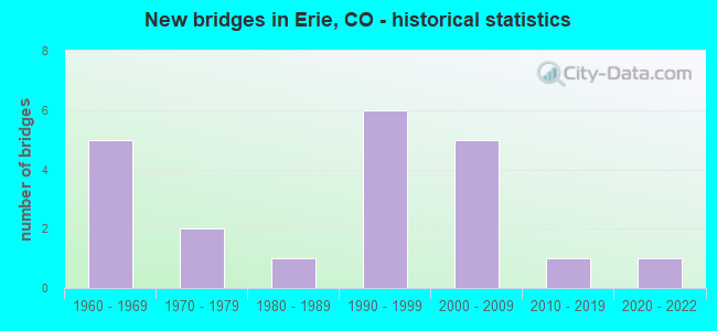
- New bridges - historical statistics
- 51960-1969
- 21970-1979
- 11980-1989
- 61990-1999
- 52000-2009
- 12010-2019
- 12020-2022


- Bridge Condition - Deck
- 40.0%Good
- 46.7%Satisfactory
- 13.3%Fair

- Bridge Condition - Superstructure
- 6.7%Very good
- 26.7%Good
- 53.3%Satisfactory
- 13.3%Fair

- Bridge Condition - Substructure
- 6.7%Very good
- 46.7%Good
- 33.3%Satisfactory
- 13.3%Fair

- Bridge Condition - Channel
- 50.0%Very good
- 16.7%Good
- 33.3%Satisfactory
Find on map >> Show street view
Structure Number: BC-38-6.7-BO1, Location: 1.5 Mi W of Co Rd 901 (Lat: 40.069733, Lng: -105.083286), Route carried "on" structure: County highway , Year Built: 1988, Status: Open, Structure Length: 2.94m (9.65ft), Average Daily Traffic: 1,853 (year 2020), Truck Traffic: 10%, Average Future Daily Traffic: 2,224 (year 2040), Design Load: HS 20, Features Intersected: Boulder Creek, Facility Carried by Structure: County Road 38
Minimum Vertical Clearance: 30+ m (98+ ft), Kilometerpoint: 0.037, Lanes on structure: 2, Owner: County Highway Agency, Approaching Roadway Width: 11.0m (36.1ft), Material/Design: Prestressed concrete continuous, Design/Construction: Tee Beam, Number Of Spans In Main Unit: 2, Length of Maximum Span: 13.7m (44.9ft), Curb-To-Curb Width: 11.0m (36.1ft), Out-to-Out Width: 11.7m (38.4ft)
Condition: Deck: Good, Superstructure: Satisfactory, Substructure: Good, Channel: Good, Operating Rating: 60.2 metric tons, Method Used To Determine Operating Rating: Load Factor (LF), Inventory Rating: 37.6 metric tons, Method Used To Determine Inventory Rating: Load Factor (LF), Structural Evaluation: Equal to present minimum criteria, Deck Geometry: Equal to present minimum criteria, Waterway Adequacy: Equal to present desirable criteria, Approach Roadway Alignment: Equal to present minimum criteria, Designated Inspection Frequency: Every 24 months, Inspection Date: Febuary 2021, Deck Structure Type: Concrete Cast-file-Place, Wearing Surface/Protective System: Wearing Surface: Bituminous
Find on map >> Show street view
Structure Number: BC-38-7.9-CO, Location: 0.2 Mi W of Co Rd 901 (Lat: 40.069444, Lng: -105.059028), Route carried "on" structure: City street , Year Built: 1965, Status: Open, Structure Length: 0.96m (3.15ft), Average Daily Traffic: 2,035 (year 2020), Truck Traffic: 11%, Average Future Daily Traffic: 2,442 (year 2040), Design Load: HS 20, Features Intersected: Coal Creek, Facility Carried by Structure: Kenosha Rd (CR 38)
Minimum Vertical Clearance: 30+ m (98+ ft), Kilometerpoint: 0.916, Lanes on structure: 2, Owner: Town or Township Highway Agency, Approaching Roadway Width: 7.3m (24.0ft), Material/Design: Prestressed concrete, Design/Construction: Tee Beam, Number Of Spans In Main Unit: 1, Length of Maximum Span: 8.8m (28.9ft), Curb-To-Curb Width: 7.9m (25.9ft), Out-to-Out Width: 8.5m (27.9ft)
Condition: Deck: Good, Superstructure: Satisfactory, Substructure: Good, Channel: Satisfactory, Operating Rating: 36.3 metric tons, Method Used To Determine Operating Rating: Field evaluation and documented engineering judgment, Inventory Rating: 32.7 metric tons, Method Used To Determine Inventory Rating: Field evaluation and documented engineering judgment, Structural Evaluation: Equal to present minimum criteria, Deck Geometry: High priority of corrective action, Waterway Adequacy: Better than present minimum criteria, Approach Roadway Alignment: Equal to present desirable criteria, Designated Inspection Frequency: Every 24 months, Inspection Date: August 2020, Deck Structure Type: Concrete Cast-file-Place, Wearing Surface/Protective System: Wearing Surface: Bituminous
Find on map >> Show street view
Structure Number: BC-901-11.6-BO, Location: 0.3 Mi N of St Hwy 52 (Lat: 40.091803, Lng: -105.055381), Route carried "on" structure: County highway , Year Built: 1976, Status: Open, Structure Length: 3.85m (12.63ft), Average Daily Traffic: 7,501 (year 2020), Truck Traffic: 20%, Average Future Daily Traffic: 9,001 (year 2040), Design Load: HS 20, Features Intersected: Boulder Creek, Facility Carried by Structure: County Road 901
Minimum Vertical Clearance: 30+ m (98+ ft), Kilometerpoint: 0.482, Lanes on structure: 2, Owner: County Highway Agency, Approaching Roadway Width: 7.3m (24.0ft), Material/Design: Prestressed concrete, Design/Construction: Tee Beam, Number Of Spans In Main Unit: 2, Length of Maximum Span: 18.8m (61.7ft), Curb-To-Curb Width: 11.0m (36.1ft), Out-to-Out Width: 11.8m (38.7ft)
Condition: Deck: Satisfactory, Superstructure: Fair, Substructure: Satisfactory, Channel: Satisfactory, Operating Rating: 36.3 metric tons, Method Used To Determine Operating Rating: Field evaluation and documented engineering judgment, Inventory Rating: 32.7 metric tons, Method Used To Determine Inventory Rating: Field evaluation and documented engineering judgment, Structural Evaluation: Somewhat better than minimum adequacy, Deck Geometry: Meets minimum limits, Waterway Adequacy: Better than present minimum criteria, Approach Roadway Alignment: Equal to present desirable criteria, Designated Inspection Frequency: Every 24 months, Inspection Date: Febuary 2021, Deck Structure Type: Concrete Cast-file-Place, Wearing Surface/Protective System: Wearing Surface: Bituminous
Find on map >> Show street view
Structure Number: D-16-DP, Location: 3.4 MI N OF LAFAYETTE (Lat: 40.012742, Lng: -105.102717), Route carried "on" structure: US 287C, Year Built: 1997, Status: Open, Structure Length: 0.62m (2.03ft), Average Daily Traffic: 26,000 (year 2020), Truck Traffic: 3%, Average Future Daily Traffic: 36,920 (year 2040), Features Intersected: LOWER BOULDER DITCH, Facility Carried by Structure: US 287 ML
Minimum Vertical Clearance: 30+ m (98+ ft), Kilometerpoint: 35.914, Lanes on structure: 4, Base Highway Network: Yes, Owner: State Highway Agency, Approaching Roadway Width: 20.4m (66.9ft), Material/Design: Concrete, Design/Construction: Culvert, Number Of Spans In Main Unit: 1, Length of Maximum Span: 6.2m (20.3ft), Out-to-Out Width: 58.7m (192.6ft)
Condition: Channel: Very good, Culverts: Satisfactory, Operating Rating: 36.3 metric tons, Method Used To Determine Operating Rating: Field evaluation and documented engineering judgment, Inventory Rating: 32.7 metric tons, Method Used To Determine Inventory Rating: Field evaluation and documented engineering judgment, Structural Evaluation: Equal to present minimum criteria, Waterway Adequacy: Superior to present desirable criteria, Approach Roadway Alignment: Equal to present desirable criteria, Designated Inspection Frequency: Every 48 months, Inspection Date: December 2021
Find on map >> Show street view
Structure Number: D-16-DS, Location: 2.4 MI E OF JCT US 287 (Lat: 40.087367, Lng: -105.057406), Route carried "on" structure: State highway 52A, Year Built: 2011, Status: Open, Structure Length: 6.66m (21.85ft), Average Daily Traffic: 14,000 (year 2020), Truck Traffic: 5%, Average Future Daily Traffic: 18,340 (year 2040), Features Intersected: BOULDER CREEK, Facility Carried by Structure: SH 52 ML
Minimum Vertical Clearance: 30+ m (98+ ft), Kilometerpoint: 11.401, Lanes on structure: 4, Base Highway Network: Yes, Owner: State Highway Agency, Approaching Roadway Width: 30.2m (99.1ft), Material/Design: Prestressed concrete continuous, Design/Construction: Box Beam or Girders - Multiple, Number Of Spans In Main Unit: 5, Length of Maximum Span: 14.6m (47.9ft), Curb-To-Curb Width: 29.3m (96.1ft), Out-to-Out Width: 30.2m (99.1ft)
Condition: Deck: Good, Superstructure: Good, Substructure: Good, Channel: Satisfactory, Inventory Rating: 75.8 metric tons, Method Used To Determine Inventory Rating: Load Factor (LF), Structural Evaluation: Better than present minimum criteria, Deck Geometry: Superior to present desirable criteria, Waterway Adequacy: Equal to present desirable criteria, Approach Roadway Alignment: Equal to present desirable criteria, Designated Inspection Frequency: Every 24 months, Inspection Date: March 2021, Deck Structure Type: Concrete Cast-file-Place, Wearing Surface/Protective System: Wearing Surface: Bituminous, Membrane: Built-up, Deck Protection: Epoxy Coated Reinforcing
Find on map >> Show street view
Structure Number: D-16-Q, Location: 3.7 MI E OF JCT US 287 (Lat: 40.087603, Lng: -105.033239), Route carried "on" structure: State highway 52A, Year Built: 1963, Status: Open, Structure Length: 0.66m (2.17ft), Average Daily Traffic: 14,000 (year 2020), Truck Traffic: 5%, Average Future Daily Traffic: 18,340 (year 2040), Design Load: HS 20, Features Intersected: LOWER BOULDER CANAL, Facility Carried by Structure: SH 52 ML
Minimum Vertical Clearance: 30+ m (98+ ft), Kilometerpoint: 13.461, Lanes on structure: 2, Base Highway Network: Yes, Owner: State Highway Agency, Approaching Roadway Width: 13.6m (44.6ft), Skew: 2 degrees, Material/Design: Concrete, Design/Construction: Culvert, Number Of Spans In Main Unit: 1, Length of Maximum Span: 6.6m (21.7ft), Curb-To-Curb Width: 26.8m (87.9ft), Out-to-Out Width: 27.4m (89.9ft)
Condition: Channel: Very good, Culverts: Satisfactory, Operating Rating: 36.3 metric tons, Method Used To Determine Operating Rating: Field evaluation and documented engineering judgment, Inventory Rating: 32.7 metric tons, Method Used To Determine Inventory Rating: Field evaluation and documented engineering judgment, Structural Evaluation: Equal to present minimum criteria, Deck Geometry: Superior to present desirable criteria, Waterway Adequacy: Equal to present desirable criteria, Approach Roadway Alignment: Equal to present desirable criteria, Designated Inspection Frequency: Every 24 months, Inspection Date: April 2021
Find on map >> Show street view
Structure Number: D-16-W, Location: 4.1 MI E OF JCT US 287 (Lat: 40.087428, Lng: -105.025267), Route carried "on" structure: State highway 52A, Year Built: 1963, Status: Open, Structure Length: 1.00m (3.28ft), Average Daily Traffic: 14,000 (year 2020), Truck Traffic: 5%, Average Future Daily Traffic: 18,340 (year 2040), Design Load: HS 20, Features Intersected: LOWER BOULDER CANAL, Facility Carried by Structure: SH 52 ML
Minimum Vertical Clearance: 30+ m (98+ ft), Kilometerpoint: 14.140, Lanes on structure: 2, Base Highway Network: Yes, Owner: State Highway Agency, Approaching Roadway Width: 12.2m (40.0ft), Skew: 5 degrees, Material/Design: Concrete, Design/Construction: Culvert, Number Of Spans In Main Unit: 1, Length of Maximum Span: 10.0m (32.8ft), Out-to-Out Width: 15.4m (50.5ft)
Condition: Channel: Satisfactory, Culverts: Satisfactory, Operating Rating: 36.3 metric tons, Method Used To Determine Operating Rating: Field evaluation and documented engineering judgment, Inventory Rating: 32.7 metric tons, Method Used To Determine Inventory Rating: Field evaluation and documented engineering judgment, Structural Evaluation: Equal to present minimum criteria, Waterway Adequacy: Equal to present desirable criteria, Approach Roadway Alignment: Equal to present desirable criteria, Designated Inspection Frequency: Every 24 months, Inspection Date: April 2021
Find on map >> Show street view
Structure Number: D-16-X, Location: 4.5 MI E OF JCT US 287 (Lat: 40.087164, Lng: -105.018583), Route carried "on" structure: State highway 52A, Year Built: 1963, Status: Open, Structure Length: 0.67m (2.20ft), Average Daily Traffic: 14,000 (year 2020), Truck Traffic: 5%, Average Future Daily Traffic: 18,340 (year 2040), Features Intersected: LOWER BOULDER CANAL, Facility Carried by Structure: SH 52 ML
Minimum Vertical Clearance: 30+ m (98+ ft), Kilometerpoint: 14.713, Lanes on structure: 3, Base Highway Network: Yes, Owner: State Highway Agency, Approaching Roadway Width: 12.2m (40.0ft), Skew: 2 degrees, Material/Design: Concrete, Design/Construction: Culvert, Number Of Spans In Main Unit: 1, Length of Maximum Span: 6.7m (22.0ft), Out-to-Out Width: 31.4m (103.0ft)
Condition: Channel: Good, Culverts: Satisfactory, Operating Rating: 36.3 metric tons, Method Used To Determine Operating Rating: Field evaluation and documented engineering judgment, Inventory Rating: 32.7 metric tons, Method Used To Determine Inventory Rating: Field evaluation and documented engineering judgment, Structural Evaluation: Equal to present minimum criteria, Waterway Adequacy: Equal to present desirable criteria, Approach Roadway Alignment: Equal to present desirable criteria, Designated Inspection Frequency: Every 24 months, Inspection Date: April 2020
Find on map >> Show street view
Structure Number: D-17-DA, Location: 4.4 MI SO OF JCT SH 56 (Lat: 40.242169, Lng: -104.980453), Route carried "on" structure: Interstate 25A, Year Built: 1961, Status: Open, Structure Length: 3.15m (10.33ft), Average Daily Traffic: 36,000 (year 2020), Truck Traffic: 10%, Average Future Daily Traffic: 53,280 (year 2040), Design Load: HS 20, Features Intersected: GW RR, Facility Carried by Structure: I 25 ML SBND
Minimum Vertical Clearance: 30+ m (98+ ft), Kilometerpoint: 395.226, Lanes on structure: 2, Base Highway Network: Yes, Owner: State Highway Agency, Approaching Roadway Width: 11.6m (38.1ft), Skew: 11 degrees, Material/Design: Steel continuous, Design/Construction: Stringer/Multi-beam, Number Of Spans In Main Unit: 3, Length of Maximum Span: 11.6m (38.1ft), Curb-To-Curb Width: 11.6m (38.1ft), Out-to-Out Width: 12.8m (42.0ft)
Condition: Deck: Satisfactory, Superstructure: Satisfactory, Substructure: Satisfactory, Operating Rating: 47.0 metric tons, Method Used To Determine Operating Rating: Load Factor (LF), Inventory Rating: 28.1 metric tons, Method Used To Determine Inventory Rating: Load Factor (LF), Structural Evaluation: Equal to present minimum criteria, Deck Geometry: Equal to present minimum criteria, Underclear: Meets minimum limits, Approach Roadway Alignment: Equal to present desirable criteria, Designated Inspection Frequency: Every 24 months, Inspection Date: June 2021, Deck Structure Type: Concrete Cast-file-Place, Wearing Surface/Protective System: Wearing Surface: Low Slump Concrete
Find on map >> Show street view
Structure Number: D-17-DY, Location: 3 MI NO OF JCT SH 7 (Lat: 40.043767, Lng: -104.981153), Route carried "on" structure: County highway , Year Built: 2004, Status: Open, Structure Length: 10.03m (32.91ft), Average Daily Traffic: 9,729 (year 2020), Truck Traffic: 10%, Average Future Daily Traffic: 8,549 (year 2029), Design Load: HS 20, Features Intersected: I 25 ML, Facility Carried by Structure: COUNTY ROAD 8
Minimum Vertical Clearance: 30+ m (98+ ft), Kilometerpoint: 5.531, Lanes on structure: 6, Lanes under structure: 6, Owner: State Highway Agency, Approaching Roadway Width: 24.4m (80.1ft), Skew: 10 degrees, Material/Design: Concrete, Design/Construction: Box Beam or Girders - Multiple, Number Of Spans In Main Unit: 3, Length of Maximum Span: 59.7m (195.9ft), Curb or Sidewalk Widths: Left: 3.0m (9.8ft), Right: 1.5m (4.9ft), Curb-To-Curb Width: 24.4m (80.1ft), Out-to-Out Width: 29.9m (98.1ft)
Condition: Deck: Good, Superstructure: Good, Substructure: Good, Operating Rating: 74.8 metric tons, Method Used To Determine Operating Rating: Load Factor (LF), Inventory Rating: 42.1 metric tons, Method Used To Determine Inventory Rating: Load Factor (LF), Structural Evaluation: Better than present minimum criteria, Deck Geometry: Somewhat better than minimum adequacy, Underclear: Equal to present minimum criteria, Approach Roadway Alignment: Equal to present desirable criteria, Length Of Structure Improvement: 6.80m (22.31ft), Designated Inspection Frequency: Every 24 months, Inspection Date: June 2021, Bridge Improvement Cost: $3,000,000, Roadway Improvement Cost: $300,000, Total Project Cost: $4,500,000, Deck Structure Type: Concrete Cast-file-Place, Wearing Surface/Protective System: Wearing Surface: Bituminous, Membrane: Built-up, Deck Protection: Epoxy Coated Reinforcing
Find on map >> Show street view
Structure Number: ERI-CHEESEMAN, Location: 300 Yd E of Cattail St (Lat: 40.051611, Lng: -105.044389), Route carried "on" structure: City street , Year Built: 1996, Status: Open, Structure Length: 2.88m (9.45ft), Average Daily Traffic: 147 (year 2020), Truck Traffic: 43%, Average Future Daily Traffic: 209 (year 2040), Design Load: HS 20, Features Intersected: Coal Creek, Facility Carried by Structure: Cheeseman Street
Minimum Vertical Clearance: 30+ m (98+ ft), Kilometerpoint: 0.935, Lanes on structure: 2, Owner: Town or Township Highway Agency, Approaching Roadway Width: 6.4m (21.0ft), Material/Design: Concrete, Design/Construction: Frame, Number Of Spans In Main Unit: 3, Length of Maximum Span: 9.1m (29.9ft), Curb or Sidewalk Widths: Left: 0.3m (1.0ft), Right: 0.3m (1.0ft), Curb-To-Curb Width: 7.1m (23.3ft), Out-to-Out Width: 7.7m (25.3ft)
Condition: Deck: Fair, Superstructure: Fair, Substructure: Fair, Channel: Satisfactory, Operating Rating: 36.3 metric tons, Method Used To Determine Operating Rating: Field evaluation and documented engineering judgment, Inventory Rating: 32.7 metric tons, Method Used To Determine Inventory Rating: Field evaluation and documented engineering judgment, Structural Evaluation: Somewhat better than minimum adequacy, Deck Geometry: Meets minimum limits, Waterway Adequacy: Somewhat better than minimum adequacy, Approach Roadway Alignment: Equal to present minimum criteria, Designated Inspection Frequency: Every 24 months, Inspection Date: May 2020, Deck Structure Type: Other, Wearing Surface/Protective System: Wearing Surface: Monolithic Concrete
Find on map >> Show street view
Structure Number: ERI-VISTAPKWY, Location: 0.5 Mi E of Co Line Rd (Lat: 40.020972, Lng: -105.046139), Route carried "on" structure: City street , Year Built: 2004, Status: Open, Structure Length: 8.05m (26.41ft), Average Daily Traffic: 5,245 (year 2020), Truck Traffic: 11%, Average Future Daily Traffic: 7,448 (year 2040), Design Load: HS 20, Features Intersected: Coal Creek, Facility Carried by Structure: Vista Parkway
Minimum Vertical Clearance: 30+ m (98+ ft), Kilometerpoint: 3.362, Lanes on structure: 2, Owner: Town or Township Highway Agency, Approaching Roadway Width: 11.0m (36.1ft), Material/Design: Prestressed concrete, Design/Construction: Stringer/Multi-beam, Number Of Spans In Main Unit: 2, Length of Maximum Span: 39.1m (128.3ft), Curb or Sidewalk Widths: Left: 0.0m, Right: 2.4m (7.9ft), Curb-To-Curb Width: 11.0m (36.1ft), Out-to-Out Width: 14.6m (47.9ft)
Condition: Deck: Good, Superstructure: Good, Substructure: Good, Channel: Very good, Operating Rating: 79.1 metric tons, Method Used To Determine Operating Rating: Load Factor (LF), Inventory Rating: 52.7 metric tons, Method Used To Determine Inventory Rating: Load Factor (LF), Structural Evaluation: Better than present minimum criteria, Deck Geometry: Meets minimum limits, Waterway Adequacy: Equal to present desirable criteria, Approach Roadway Alignment: Better than present minimum criteria, Designated Inspection Frequency: Every 24 months, Inspection Date: May 2020, Deck Structure Type: Concrete Cast-file-Place, Wearing Surface/Protective System: Wearing Surface: Bituminous, Membrane: Preformed Fabric, Deck Protection: Epoxy Coated Reinforcing
Find on map >> Show street view
Structure Number: ERI001.0-008.0A, Location: 0.4 Mi N of Cheeseman St (Lat: 40.057528, Lng: -105.055500), Route carried "on" structure: City street , Year Built: 1996, Status: Open, Structure Length: 0.67m (2.20ft), Average Daily Traffic: 7,815 (year 2020), Truck Traffic: 13%, Average Future Daily Traffic: 11,097 (year 2040), Design Load: HS 20, Features Intersected: Lower Boulder Ditch, Facility Carried by Structure: CR 1 (Co Line Rd)
Minimum Vertical Clearance: 30+ m (98+ ft), Kilometerpoint: 6.461, Lanes on structure: 2, Owner: Town or Township Highway Agency, Approaching Roadway Width: 7.6m (24.9ft), Skew: 1 degrees, Material/Design: Concrete, Design/Construction: Frame, Number Of Spans In Main Unit: 1, Length of Maximum Span: 6.1m (20.0ft), Curb-To-Curb Width: 11.0m (36.1ft), Out-to-Out Width: 12.0m (39.4ft)
Condition: Deck: Satisfactory, Superstructure: Satisfactory, Substructure: Satisfactory, Channel: Very good, Operating Rating: 36.3 metric tons, Method Used To Determine Operating Rating: Field evaluation and documented engineering judgment, Inventory Rating: 32.7 metric tons, Method Used To Determine Inventory Rating: Field evaluation and documented engineering judgment, Structural Evaluation: Equal to present minimum criteria, Deck Geometry: Meets minimum limits, Waterway Adequacy: Equal to present desirable criteria, Approach Roadway Alignment: Equal to present desirable criteria, Designated Inspection Frequency: Every 24 months, Inspection Date: Febuary 2022, Deck Structure Type: Concrete Cast-file-Place, Wearing Surface/Protective System: Wearing Surface: Bituminous
Find on map >> Show street view
Structure Number: ERI001.0-010.0A, Location: 300 Ft N of Bixler Blvd (Lat: 40.063194, Lng: -105.055500), Route carried "on" structure: City street , Year Built: 1996, Status: Open, Structure Length: 0.74m (2.43ft), Average Daily Traffic: 6,479 (year 2020), Truck Traffic: 15%, Average Future Daily Traffic: 9,200 (year 2040), Design Load: HS 20, Features Intersected: Coal Creek, Facility Carried by Structure: County Road 1
Minimum Vertical Clearance: 30+ m (98+ ft), Kilometerpoint: 7.089, Lanes on structure: 2, Owner: Town or Township Highway Agency, Approaching Roadway Width: 7.3m (24.0ft), Material/Design: Concrete, Design/Construction: Frame, Number Of Spans In Main Unit: 1, Length of Maximum Span: 6.8m (22.3ft), Curb-To-Curb Width: 10.0m (32.8ft), Out-to-Out Width: 10.8m (35.4ft)
Condition: Deck: Satisfactory, Superstructure: Satisfactory, Substructure: Fair, Channel: Good, Operating Rating: 36.3 metric tons, Method Used To Determine Operating Rating: Field evaluation and documented engineering judgment, Inventory Rating: 32.7 metric tons, Method Used To Determine Inventory Rating: Field evaluation and documented engineering judgment, Structural Evaluation: Somewhat better than minimum adequacy, Deck Geometry: Meets minimum limits, Waterway Adequacy: Equal to present minimum criteria, Approach Roadway Alignment: Equal to present desirable criteria, Designated Inspection Frequency: Every 24 months, Inspection Date: May 2020, Deck Structure Type: Other, Wearing Surface/Protective System: Wearing Surface: Bituminous, Deck Protection: Epoxy Coated Reinforcing
Find on map >> Show street view
Structure Number: ERI001.5_008.5A, Location: 0.4 M N of Co Rd 8.5 (Lat: 40.053789, Lng: -105.047444), Route carried "on" structure: City street , Year Built: 1999, Status: Open, Structure Length: 0.74m (2.43ft), Average Daily Traffic: 2,224 (year 2020), Truck Traffic: 10%, Average Future Daily Traffic: 3,158 (year 2040), Design Load: HS 20, Features Intersected: Lower Boulder Ditch, Facility Carried by Structure: CR 1.5 (Briggs St)
Minimum Vertical Clearance: 30+ m (98+ ft), Kilometerpoint: 1.123, Lanes on structure: 2, Owner: Town or Township Highway Agency, Approaching Roadway Width: 7.6m (24.9ft), Skew: 3 degrees, Material/Design: Concrete, Design/Construction: Culvert, Number Of Spans In Main Unit: 1, Length of Maximum Span: 7.4m (24.3ft), Curb or Sidewalk Widths: Left: 0.0m, Right: 1.8m (5.9ft), Curb-To-Curb Width: 8.5m (27.9ft), Out-to-Out Width: 11.2m (36.7ft)
Condition: Channel: Very good, Culverts: Satisfactory, Operating Rating: 41.9 metric tons, Method Used To Determine Operating Rating: Load Factor (LF), Inventory Rating: 25.0 metric tons, Method Used To Determine Inventory Rating: Load Factor (LF), Structural Evaluation: Equal to present minimum criteria, Deck Geometry: Meets minimum limits, Waterway Adequacy: Equal to present desirable criteria, Approach Roadway Alignment: Equal to present desirable criteria, Designated Inspection Frequency: Every 24 months, Inspection Date: Febuary 2022, Deck Structure Type: Concrete Cast-file-Place, Wearing Surface/Protective System: Wearing Surface: Bituminous, Deck Protection: Epoxy Coated Reinforcing
Find on map >> Show street view
Structure Number: ERI001.5_008.5B, Location: 0.4 Mi NE of Co Rd 8.5 (Lat: 40.054972, Lng: -105.047278), Route carried "on" structure: City street , Year Built: 1999, Status: Open, Structure Length: 4.01m (13.16ft), Average Daily Traffic: 2,160 (year 2020), Truck Traffic: 11%, Average Future Daily Traffic: 3,067 (year 2040), Design Load: HS 20, Features Intersected: Coal Creek, Facility Carried by Structure: CR 1.5 (Briggs St)
Minimum Vertical Clearance: 30+ m (98+ ft), Kilometerpoint: 0.041, Lanes on structure: 2, Owner: Town or Township Highway Agency, Approaching Roadway Width: 7.6m (24.9ft), Skew: 3 degrees, Material/Design: Prestressed concrete, Design/Construction: Box Beam or Girders - Single/Spread, Number Of Spans In Main Unit: 3, Length of Maximum Span: 15.8m (51.8ft), Curb or Sidewalk Widths: Left: 1.8m (5.9ft), Right: 1.8m (5.9ft), Curb-To-Curb Width: 8.5m (27.9ft), Out-to-Out Width: 13.0m (42.7ft)
Condition: Deck: Satisfactory, Superstructure: Very good, Substructure: Good, Channel: Satisfactory, Operating Rating: 93.7 metric tons, Method Used To Determine Operating Rating: Load Factor (LF), Inventory Rating: 56.2 metric tons, Method Used To Determine Inventory Rating: Load Factor (LF), Structural Evaluation: Better than present minimum criteria, Deck Geometry: Meets minimum limits, Waterway Adequacy: Equal to present desirable criteria, Approach Roadway Alignment: Equal to present desirable criteria, Designated Inspection Frequency: Every 24 months, Inspection Date: May 2020, Deck Structure Type: Concrete Cast-file-Place, Wearing Surface/Protective System: Wearing Surface: Monolithic Concrete, Deck Protection: Epoxy Coated Reinforcing
Find on map >> Show street view
Structure Number: ERI005.0-014.0A, Location: 100 FT N of St Hwy 52 (Lat: 40.087639, Lng: -105.017750), Route carried "on" structure: City street , Year Built: 1978, Status: Open, Structure Length: 0.69m (2.26ft), Average Daily Traffic: 747 (year 2020), Truck Traffic: 47%, Average Future Daily Traffic: 1,061 (year 2040), Design Load: HS 20, Features Intersected: Sullivan Ditch, Facility Carried by Structure: County Road 5
Minimum Vertical Clearance: 30+ m (98+ ft), Kilometerpoint: 1.629, Lanes on structure: 2, Owner: Town or Township Highway Agency, Approaching Roadway Width: 5.5m (18.0ft), Material/Design: Steel, Design/Construction: Stringer/Multi-beam, Number Of Spans In Main Unit: 1, Length of Maximum Span: 6.3m (20.7ft), Curb-To-Curb Width: 9.4m (30.8ft), Out-to-Out Width: 9.8m (32.2ft)
Condition: Deck: Satisfactory, Superstructure: Satisfactory, Substructure: Good, Channel: Very good, Operating Rating: 60.2 metric tons, Method Used To Determine Operating Rating: Load Factor (LF), Inventory Rating: 36.1 metric tons, Method Used To Determine Inventory Rating: Load Factor (LF), Structural Evaluation: Equal to present minimum criteria, Deck Geometry: Equal to present minimum criteria, Waterway Adequacy: Equal to present desirable criteria, Approach Roadway Alignment: Equal to present desirable criteria, Designated Inspection Frequency: Every 24 months, Inspection Date: Febuary 2022, Deck Structure Type: Corrugated Steel, Wearing Surface/Protective System: Wearing Surface: Bituminous
Find on map >> Show street view
Structure Number: ERI008.0_001.5B, Location: 0.3 Mi East of Co Rd 1.5 (Lat: 40.043889, Lng: -105.043306), Route carried "on" structure: City street , Year Built: 2020, Status: Open, Structure Length: 6.91m (22.67ft), Average Daily Traffic: 11,773 (year 2016), Truck Traffic: 9%, Average Future Daily Traffic: 19,308 (year 2036), Design Load: HL 93, Features Intersected: Coal Creek, Facility Carried by Structure: CR 8 (Erie Pkwy)
Minimum Vertical Clearance: 30+ m (98+ ft), Kilometerpoint: 0.167, Lanes on structure: 4, Owner: Town or Township Highway Agency, Approaching Roadway Width: 20.0m (65.6ft), Skew: 17 degrees, Material/Design: Prestressed concrete continuous, Design/Construction: Girder and Floorbeam System, Number Of Spans In Main Unit: 3, Length of Maximum Span: 22.6m (74.1ft), Curb or Sidewalk Widths: Left: 2.4m (7.9ft), Right: 2.4m (7.9ft), Curb-To-Curb Width: 20.0m (65.6ft), Out-to-Out Width: 26.5m (86.9ft)
Condition: Deck: Good, Superstructure: Good, Substructure: Very good, Channel: Very good, Operating Rating: 61.6 metric tons, Method Used To Determine Operating Rating: Load and Resistance Factor Rating (LRFR) rating reported by rating factor(RF) method using HL-93 loadings, Inventory Rating: 48.6 metric tons, Method Used To Determine Inventory Rating: Load and Resistance Factor Rating (LRFR) rating reported by rating factor(RF) method using HL-93 loadings, Structural Evaluation: Better than present minimum criteria, Deck Geometry: Better than present minimum criteria, Waterway Adequacy: Equal to present desirable criteria, Approach Roadway Alignment: Equal to present desirable criteria, Designated Inspection Frequency: Every 24 months, Inspection Date: May 2020, Deck Structure Type: Concrete Cast-file-Place, Wearing Surface/Protective System: Wearing Surface: Bituminous, Membrane: Epoxy, Deck Protection: Epoxy Coated Reinforcing
Find on map >> Show street view
Structure Number: WEL003.0_012.0A, Location: 0.4 Mi N of Co Rd 12 (Lat: 40.077500, Lng: -105.037222), Route carried "on" structure: City street , Year Built: 2003, Status: Open, Structure Length: 1.26m (4.13ft), Average Daily Traffic: 2,100 (year 2020), Truck Traffic: 21%, Average Future Daily Traffic: 2,982 (year 2040), Design Load: HS 20, Features Intersected: Sullivan Ditch, Facility Carried by Structure: County Road 3
Minimum Vertical Clearance: 30+ m (98+ ft), Kilometerpoint: 1.257, Lanes on structure: 2, Owner: Town or Township Highway Agency, Approaching Roadway Width: 7.3m (24.0ft), Material/Design: Steel, Design/Construction: Stringer/Multi-beam, Number Of Spans In Main Unit: 1, Length of Maximum Span: 12.0m (39.4ft), Curb-To-Curb Width: 10.5m (34.4ft), Out-to-Out Width: 10.7m (35.1ft)
Condition: Deck: Satisfactory, Superstructure: Satisfactory, Substructure: Satisfactory, Channel: Very good, Operating Rating: 44.9 metric tons, Method Used To Determine Operating Rating: Load Factor (LF), Inventory Rating: 26.9 metric tons, Method Used To Determine Inventory Rating: Load Factor (LF), Structural Evaluation: Equal to present minimum criteria, Deck Geometry: Somewhat better than minimum adequacy, Waterway Adequacy: Equal to present desirable criteria, Approach Roadway Alignment: Equal to present desirable criteria, Designated Inspection Frequency: Every 24 months, Inspection Date: Febuary 2022, Deck Structure Type: Corrugated Steel, Wearing Surface/Protective System: Wearing Surface: Bituminous
Find on map >> Show street view
Structure Number: WEL003.0_012.0B, Location: 0.6 Mi N of Co Rd 12 (Lat: 40.079861, Lng: -105.037167), Route carried "on" structure: City street , Year Built: 2004, Status: Open, Structure Length: 1.45m (4.76ft), Average Daily Traffic: 2,100 (year 2020), Truck Traffic: 21%, Average Future Daily Traffic: 2,982 (year 2040), Design Load: HS 20, Features Intersected: Sullivan Ditch, Facility Carried by Structure: County Road 3
Minimum Vertical Clearance: 30+ m (98+ ft), Kilometerpoint: 1.588, Lanes on structure: 2, Owner: Town or Township Highway Agency, Approaching Roadway Width: 7.3m (24.0ft), Skew: 5 degrees, Material/Design: Steel, Design/Construction: Stringer/Multi-beam, Number Of Spans In Main Unit: 1, Length of Maximum Span: 13.2m (43.3ft), Curb-To-Curb Width: 11.6m (38.1ft), Out-to-Out Width: 11.9m (39.0ft)
Condition: Deck: Fair, Superstructure: Satisfactory, Substructure: Satisfactory, Channel: Very good, Operating Rating: 36.5 metric tons, Method Used To Determine Operating Rating: Load Factor (LF), Inventory Rating: 21.9 metric tons, Method Used To Determine Inventory Rating: Load Factor (LF), Structural Evaluation: Somewhat better than minimum adequacy, Deck Geometry: Somewhat better than minimum adequacy, Waterway Adequacy: Equal to present desirable criteria, Approach Roadway Alignment: Equal to present desirable criteria, Designated Inspection Frequency: Every 24 months, Inspection Date: Febuary 2022, Deck Structure Type: Corrugated Steel, Wearing Surface/Protective System: Wearing Surface: Bituminous
Find on map >> Show street view
Structure Number: D-17-DY, Location: 3 MI NO OF JCT SH 7 (Lat: 40.043767, Lng: -104.981153), Route carried "under" structure: Interstate 25A, Year Built: 2004, Structure Length: 0. m, Average Daily Traffic: 8,867 (year 2016), Truck Traffic: 7%, Features Intersected: I 25 ML, Facility Carried by Structure: COUNTY ROAD 8
Minimum Vertical Clearance: 30+ m (98+ ft), Kilometerpoint: 5.415, Lanes on structure: 6, Lanes under structure: 6, Material/Design: Concrete, Design/Construction: Box Beam or Girders - Multiple, Length of Maximum Span: 59.7m (195.9ft)