Bridge Statistics for Ephrata, Pennsylvania (PA)
Condition, Traffic, Stress, Structural Evaluation, Project Costs
- National Bridge Inventory (NBI) Statistics
- 29Number of bridges
- 213ft / 65.3mTotal length
- $7,468,000Total costs
- 259,612Total average daily traffic
- 25,770Total average daily truck traffic
- National Bridge Inventory (NBI) Registered Bridges for Ephrata
- No street view available for this location
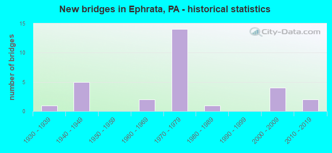
- New bridges - historical statistics
- 11930-1939
- 51940-1949
- 21960-1969
- 141970-1979
- 11980-1989
- 42000-2009
- 22010-2019

- Reconstructed bridges - Historical Statistics
- 12000-2009
- 12010-2019


- Bridge Condition - Deck
- 15.8%Very good
- 57.9%Good
- 10.5%Satisfactory
- 5.3%Fair
- 10.5%Poor

- Bridge Condition - Superstructure
- 10.5%Excellent
- 26.3%Very good
- 15.8%Good
- 21.1%Satisfactory
- 15.8%Fair
- 10.5%Poor

- Bridge Condition - Substructure
- 10.5%Very good
- 42.1%Good
- 36.8%Satisfactory
- 5.3%Fair
- 5.3%Poor

- Bridge Condition - Channel
- 50.0%Good
- 33.3%Satisfactory
- 16.7%Fair
Find on map >> Show street view
Structure Number: 212, Location: FU07 OFF FLAUGHERTY RUN R (Lat: 40.551153, Lng: -80.218950), Route carried "on" structure: Other road , Year Built: 1934, Status: Posted for load, Structure Length: 1.37m (4.49ft), Average Daily Traffic: 40 (year 2005), Truck Traffic: 1%, Average Future Daily Traffic: 50 (year 2023), Design Load: HS 20, Features Intersected: FLAUGHERTY RUN, Facility Carried by Structure: PRIVATE ACCESS RD
Minimum Vertical Clearance: 30+ m (98+ ft), Kilometerpoint: 0.000, Lanes on structure: 2, Owner: County Highway Agency, Approaching Roadway Width: 3.0m (9.8ft), Material/Design: Steel, Design/Construction: Stringer/Multi-beam, Number Of Spans In Main Unit: 1, Length of Maximum Span: 12.8m (42.0ft), Curb or Sidewalk Widths: Left: 0.1m (0.3ft), Right: 0.1m (0.3ft), Curb-To-Curb Width: 2.9m (9.5ft), Out-to-Out Width: 3.5m (11.5ft)
Condition: Deck: Fair, Superstructure: Fair, Substructure: Satisfactory, Channel: Fair, Operating Rating: 22.7 metric tons, Method Used To Determine Operating Rating: Load Factor (LF), Inventory Rating: 13.6 metric tons, Method Used To Determine Inventory Rating: Load Factor (LF), Structural Evaluation: Meets minimum limits, Deck Geometry: High priority of replacement, Waterway Adequacy: Superior to present desirable criteria, Approach Roadway Alignment: Meets minimum limits, Bridge Posting: Required (Relationship of Operating Rating to Maximum Legal Load: > 39.9% below), Length Of Structure Improvement: 1.50m (4.92ft), Designated Inspection Frequency: Every 24 months, Critical Feature Inspection Frequency: Every 12 months, Other Special Inspection Frequency: Every 12 months, Inspection Date: August 2020, Critical Feature Inspection Date: August 2021, Other Special Inspection Date: August 2021, Bridge Improvement Cost: $4,000, Roadway Improvement Cost: $25,000, Total Project Cost: $55,000, Deck Structure Type: Concrete Cast-file-Place, Wearing Surface/Protective System: Wearing Surface: Monolithic Concrete
Find on map >> Show street view
Structure Number: 4551, Location: WOODBURY (Lat: 40.223303, Lng: -78.369322), Route carried "on" structure: City street , Year Built: 1974, Status: Open, Structure Length: 1.31m (4.30ft), Average Daily Traffic: 50 (year 2020), Average Future Daily Traffic: 68 (year 2040), Design Load: HS 20, Features Intersected: YELLOW CREEK, Facility Carried by Structure: T-634, Mill Street
Minimum Vertical Clearance: 30+ m (98+ ft), Kilometerpoint: 0.000, Lanes on structure: 1, Owner: County Highway Agency, Approaching Roadway Width: 3.7m (12.1ft), Material/Design: Prestressed concrete, Design/Construction: Box Beam or Girders - Multiple, Number Of Spans In Main Unit: 1, Length of Maximum Span: 12.5m (41.0ft), Curb-To-Curb Width: 4.7m (15.4ft), Out-to-Out Width: 4.9m (16.1ft)
Condition: Deck: Poor, Superstructure: Poor, Substructure: Fair, Channel: Satisfactory, Operating Rating: 59.0 metric tons, Method Used To Determine Operating Rating: Load Factor (LF), Inventory Rating: 34.5 metric tons, Method Used To Determine Inventory Rating: Load Factor (LF), Structural Evaluation: Meets minimum limits, Deck Geometry: Better than present minimum criteria, Waterway Adequacy: Better than present minimum criteria, Approach Roadway Alignment: Equal to present desirable criteria, Length Of Structure Improvement: 1.60m (5.25ft), Designated Inspection Frequency: Every 24 months, Inspection Date: October 2020, Bridge Improvement Cost: $54,000, Roadway Improvement Cost: $265,000, Total Project Cost: $730,000, Deck Structure Type: Other, Wearing Surface/Protective System: Wearing Surface: Bituminous
Find on map >> Show street view
Structure Number: 211, Location: 0.25 MI.S. OF US 322 (Lat: 40.157364, Lng: -76.153825), Route carried "on" structure: US 222, Year Built: 1970, Status: Open, Structure Length: 3.96m (12.99ft), Average Daily Traffic: 23,942 (year 2020), Truck Traffic: 13%, Average Future Daily Traffic: 26,505 (year 2032), Design Load: HS 20, Features Intersected: SR1013 Pleas. Valley Rd.
Minimum Vertical Clearance: 30+ m (98+ ft), Kilometerpoint: 64.021, Lanes on structure: 2, Lanes under structure: 2, Base Highway Network: Yes, Owner: State Highway Agency, Approaching Roadway Width: 11.6m (38.1ft), Skew: 10 degrees, Material/Design: Prestressed concrete, Design/Construction: Stringer/Multi-beam, Number Of Spans In Main Unit: 1, Number Of Approach Spans: 2, Length of Maximum Span: 25.6m (84.0ft), Curb or Sidewalk Widths: Left: 0.2m (0.7ft), Right: 0.2m (0.7ft), Curb-To-Curb Width: 12.0m (39.4ft), Out-to-Out Width: 13.2m (43.3ft)
Condition: Deck: Good, Superstructure: Good, Substructure: Good, Operating Rating: 71.7 metric tons, Method Used To Determine Operating Rating: Load Factor (LF), Inventory Rating: 26.3 metric tons, Method Used To Determine Inventory Rating: Load Factor (LF), Structural Evaluation: Equal to present minimum criteria, Deck Geometry: Better than present minimum criteria, Underclear: Superior to present desirable criteria, Approach Roadway Alignment: Equal to present desirable criteria, Length Of Structure Improvement: 4.90m (16.08ft), Designated Inspection Frequency: Every 24 months, Inspection Date: August 2020, Bridge Improvement Cost: $15,000, Roadway Improvement Cost: $45,000, Total Project Cost: $206,000, Deck Structure Type: Concrete Cast-file-Place, Wearing Surface/Protective System: Wearing Surface: Latex Concrete
Find on map >> Show street view
Structure Number: 21101, Location: SE OF EPHRATA (Lat: 40.157494, Lng: -76.154078), Route carried "on" structure: US 222, Year Built: 1970, Status: Open, Structure Length: 3.96m (12.99ft), Average Daily Traffic: 23,601 (year 2020), Truck Traffic: 14%, Average Future Daily Traffic: 28,240 (year 2032), Design Load: HS 20, Features Intersected: SR1013 Pleas. Valley Rd.
Minimum Vertical Clearance: 30+ m (98+ ft), Kilometerpoint: 64.037, Lanes on structure: 2, Lanes under structure: 2, Base Highway Network: Yes, Owner: State Highway Agency, Approaching Roadway Width: 11.6m (38.1ft), Skew: 10 degrees, Material/Design: Prestressed concrete, Design/Construction: Stringer/Multi-beam, Number Of Spans In Main Unit: 1, Number Of Approach Spans: 2, Length of Maximum Span: 25.6m (84.0ft), Curb or Sidewalk Widths: Left: 0.2m (0.7ft), Right: 0.2m (0.7ft), Curb-To-Curb Width: 12.0m (39.4ft), Out-to-Out Width: 13.2m (43.3ft)
Condition: Deck: Very good, Superstructure: Satisfactory, Substructure: Satisfactory, Operating Rating: 71.7 metric tons, Method Used To Determine Operating Rating: Load Factor (LF), Inventory Rating: 26.3 metric tons, Method Used To Determine Inventory Rating: Load Factor (LF), Structural Evaluation: Equal to present minimum criteria, Deck Geometry: Better than present minimum criteria, Underclear: Equal to present minimum criteria, Approach Roadway Alignment: Equal to present desirable criteria, Length Of Structure Improvement: 4.80m (15.75ft), Designated Inspection Frequency: Every 24 months, Inspection Date: August 2020, Deck Structure Type: Concrete Cast-file-Place, Wearing Surface/Protective System: Wearing Surface: Latex Concrete
Find on map >> Show street view
Structure Number: 21103, Location: 0.75 MI.S.E. OF EPHRATA (Lat: 40.163453, Lng: -76.151558), Route carried "on" structure: US 222, Year Built: 1970, Status: Open, Structure Length: 6.74m (22.11ft), Average Daily Traffic: 19,535 (year 2020), Truck Traffic: 19%, Average Future Daily Traffic: 24,865 (year 2032), Design Load: HS 20, Features Intersected: US 322; SR 0322
Minimum Vertical Clearance: 30+ m (98+ ft), Kilometerpoint: 65.066, Lanes on structure: 2, Lanes under structure: 6, Base Highway Network: Yes, Owner: State Highway Agency, Approaching Roadway Width: 11.6m (38.1ft), Skew: 11 degrees, Material/Design: Steel, Design/Construction: Stringer/Multi-beam, Number Of Spans In Main Unit: 1, Number Of Approach Spans: 2, Length of Maximum Span: 39.6m (129.9ft), Curb or Sidewalk Widths: Left: 0.2m (0.7ft), Right: 0.2m (0.7ft), Curb-To-Curb Width: 12.0m (39.4ft), Out-to-Out Width: 13.2m (43.3ft)
Condition: Deck: Good, Superstructure: Fair, Substructure: Satisfactory, Operating Rating: 59.0 metric tons, Method Used To Determine Operating Rating: Load Factor (LF), Inventory Rating: 35.4 metric tons, Method Used To Determine Inventory Rating: Load Factor (LF), Structural Evaluation: Somewhat better than minimum adequacy, Deck Geometry: Equal to present minimum criteria, Underclear: Better than present minimum criteria, Approach Roadway Alignment: Equal to present desirable criteria, Length Of Structure Improvement: 7.70m (25.26ft), Designated Inspection Frequency: Every 24 months, Inspection Date: June 2020, Bridge Improvement Cost: $32,000, Roadway Improvement Cost: $94,000, Total Project Cost: $432,000, Deck Structure Type: Concrete Cast-file-Place, Wearing Surface/Protective System: Wearing Surface: Latex Concrete
Find on map >> Show street view
Structure Number: 21104, Location: 1 MI. N.E. OF US 322 (Lat: 40.176992, Lng: -76.139978), Route carried "on" structure: State highway , Year Built: 1971, Status: Open, Structure Length: 10.49m (34.42ft), Average Daily Traffic: 3,212 (year 2022), Truck Traffic: 4%, Average Future Daily Traffic: 3,414 (year 2032), Design Load: HS 20, Features Intersected: US 222; SR 0222, Facility Carried by Structure: 1080 Mohler Church
Minimum Vertical Clearance: 30+ m (98+ ft), Kilometerpoint: 0.000, Lanes on structure: 2, Lanes under structure: 8, Owner: State Highway Agency, Approaching Roadway Width: 9.1m (29.9ft), Skew: 2 degrees, Material/Design: Steel continuous, Design/Construction: Stringer/Multi-beam, Number Of Spans In Main Unit: 2, Number Of Approach Spans: 2, Length of Maximum Span: 38.1m (125.0ft), Curb or Sidewalk Widths: Left: 0.2m (0.7ft), Right: 0.2m (0.7ft), Curb-To-Curb Width: 13.4m (44.0ft), Out-to-Out Width: 14.6m (47.9ft)
Condition: Deck: Good, Superstructure: Good, Substructure: Good, Operating Rating: 61.7 metric tons, Method Used To Determine Operating Rating: Load Factor (LF), Inventory Rating: 37.2 metric tons, Method Used To Determine Inventory Rating: Load Factor (LF), Structural Evaluation: Better than present minimum criteria, Deck Geometry: Better than present minimum criteria, Underclear: High priority of corrective action, Approach Roadway Alignment: Equal to present desirable criteria, Length Of Structure Improvement: 11.50m (37.73ft), Designated Inspection Frequency: Every 24 months, Inspection Date: December 2020, Bridge Improvement Cost: $173,000, Roadway Improvement Cost: $509,000, Total Project Cost: $2,334,000, Deck Structure Type: Concrete Cast-file-Place, Wearing Surface/Protective System: Wearing Surface: Latex Concrete
Find on map >> Show street view
Structure Number: 21155, Location: NW End of Ephrata Boro (Lat: 40.185703, Lng: -76.187586), Route carried "on" structure: State highway 272, Year Built: 1944, Year Reconstructed: 2015, Status: Open, Structure Length: 2.19m (7.19ft), Average Daily Traffic: 16,468 (year 2022), Truck Traffic: 6%, Average Future Daily Traffic: 17,774 (year 2032), Design Load: HS 20, Features Intersected: US 322; Main St
Minimum Vertical Clearance: 30+ m (98+ ft), Kilometerpoint: 53.166, Lanes on structure: 4, Lanes under structure: 8, Owner: State Highway Agency, Approaching Roadway Width: 20.1m (65.9ft), Skew: 20 degrees, Material/Design: Steel, Design/Construction: Stringer/Multi-beam, Number Of Spans In Main Unit: 1, Length of Maximum Span: 20.7m (67.9ft), Curb or Sidewalk Widths: Left: 0.0m, Right: 1.5m (4.9ft), Curb-To-Curb Width: 17.2m (56.4ft), Out-to-Out Width: 19.5m (64.0ft)
Condition: Deck: Good, Superstructure: Fair, Substructure: Satisfactory, Inventory Rating: 63.5 metric tons, Method Used To Determine Inventory Rating: Load Factor (LF), Structural Evaluation: Somewhat better than minimum adequacy, Deck Geometry: Somewhat better than minimum adequacy, Underclear: Meets minimum limits, Approach Roadway Alignment: Equal to present desirable criteria, Length Of Structure Improvement: 2.80m (9.19ft), Designated Inspection Frequency: Every 24 months, Inspection Date: March 2021, Bridge Improvement Cost: $150,000, Roadway Improvement Cost: $442,000, Total Project Cost: $2,025,000, Deck Structure Type: Concrete Cast-file-Place, Wearing Surface/Protective System: Wearing Surface: Monolithic Concrete, Membrane: Epoxy, Deck Protection: Epoxy Coated Reinforcing
Find on map >> Show street view
Structure Number: 21157, Location: N OF EPHRATA BORO (Lat: 40.200181, Lng: -76.164125), Route carried "on" structure: State highway 272, Year Built: 1942, Year Reconstructed: 2013, Status: Open, Structure Length: 4.88m (16.01ft), Average Daily Traffic: 14,253 (year 2022), Truck Traffic: 9%, Average Future Daily Traffic: 19,190 (year 2032), Design Load: HS 20, Features Intersected: East Penn R.R.
Minimum Vertical Clearance: 30+ m (98+ ft), Kilometerpoint: 55.973, Lanes on structure: 2, Owner: State Highway Agency, Approaching Roadway Width: 9.1m (29.9ft), Skew: 4 degrees, Material/Design: Prestressed concrete, Design/Construction: Box Beam or Girders - Single/Spread, Number Of Spans In Main Unit: 1, Number Of Approach Spans: 2, Length of Maximum Span: 16.5m (54.1ft), Curb-To-Curb Width: 10.0m (32.8ft), Out-to-Out Width: 10.9m (35.8ft)
Condition: Deck: Good, Superstructure: Very good, Substructure: Good, Operating Rating: 91.6 metric tons, Method Used To Determine Operating Rating: Load Factor (LF), Inventory Rating: 48.1 metric tons, Method Used To Determine Inventory Rating: Load Factor (LF), Structural Evaluation: Better than present minimum criteria, Deck Geometry: Meets minimum limits, Underclear: High priority of replacement, Approach Roadway Alignment: Equal to present desirable criteria, Length Of Structure Improvement: 5.70m (18.70ft), Designated Inspection Frequency: Every 24 months, Inspection Date: April 2021, Bridge Improvement Cost: $112,000, Roadway Improvement Cost: $331,000, Total Project Cost: $1,517,000, Deck Structure Type: Concrete Cast-file-Place, Wearing Surface/Protective System: Wearing Surface: Monolithic Concrete, Deck Protection: Epoxy Coated Reinforcing
Find on map >> Show street view
Structure Number: 212, Location: EPHRATA BORO (Lat: 40.182067, Lng: -76.184008), Route carried "on" structure: US 322, Year Built: 1964, Status: Open, Structure Length: 2.90m (9.51ft), Average Daily Traffic: 14,516 (year 2022), Truck Traffic: 4%, Average Future Daily Traffic: 16,742 (year 2032), Design Load: HS 20, Features Intersected: COCALICO CREEK
Minimum Vertical Clearance: 30+ m (98+ ft), Kilometerpoint: 17.843, Lanes on structure: 2, Base Highway Network: Yes, Owner: State Highway Agency, Approaching Roadway Width: 12.2m (40.0ft), Skew: 3 degrees, Material/Design: Prestressed concrete, Design/Construction: Box Beam or Girders - Multiple, Number Of Spans In Main Unit: 2, Length of Maximum Span: 13.7m (44.9ft), Curb or Sidewalk Widths: Left: 1.6m (5.2ft), Right: 1.6m (5.2ft), Curb-To-Curb Width: 12.2m (40.0ft), Out-to-Out Width: 16.0m (52.5ft)
Condition: Deck: Satisfactory, Superstructure: Satisfactory, Substructure: Satisfactory, Channel: Satisfactory, Operating Rating: 91.6 metric tons, Method Used To Determine Operating Rating: Load Factor (LF), Inventory Rating: 37.2 metric tons, Method Used To Determine Inventory Rating: Load Factor (LF), Structural Evaluation: Equal to present minimum criteria, Deck Geometry: Somewhat better than minimum adequacy, Waterway Adequacy: Equal to present minimum criteria, Approach Roadway Alignment: Equal to present minimum criteria, Length Of Structure Improvement: 3.70m (12.14ft), Designated Inspection Frequency: Every 24 months, Inspection Date: March 2021, Bridge Improvement Cost: $10,000, Roadway Improvement Cost: $29,000, Total Project Cost: $133,000, Deck Structure Type: Concrete Cast-file-Place, Wearing Surface/Protective System: Wearing Surface: Bituminous, Membrane: Preformed Fabric
Find on map >> Show street view
Structure Number: 21471, Location: N.SIDE EPHRATA,CHURCH ST. (Lat: 40.186483, Lng: -76.171369), Route carried "on" structure: State highway , Year Built: 1986, Status: Open, Structure Length: 2.59m (8.50ft), Average Daily Traffic: 5,677 (year 2022), Truck Traffic: 5%, Average Future Daily Traffic: 6,212 (year 2032), Design Load: HS 25 or greater, Features Intersected: COCALICO CREEK, Facility Carried by Structure: SR 1047 Church St
Minimum Vertical Clearance: 30+ m (98+ ft), Kilometerpoint: 0.000, Lanes on structure: 2, Owner: State Highway Agency, Approaching Roadway Width: 12.2m (40.0ft), Skew: 1 degrees, Material/Design: Prestressed concrete, Design/Construction: Box Beam or Girders - Multiple, Number Of Spans In Main Unit: 1, Length of Maximum Span: 25.9m (85.0ft), Curb or Sidewalk Widths: Left: 0.2m (0.7ft), Right: 1.2m (3.9ft), Curb-To-Curb Width: 12.2m (40.0ft), Out-to-Out Width: 14.8m (48.6ft)
Condition: Deck: Satisfactory, Superstructure: Good, Substructure: Good, Channel: Good, Operating Rating: 89.8 metric tons, Method Used To Determine Operating Rating: Load Factor (LF), Inventory Rating: 58.1 metric tons, Method Used To Determine Inventory Rating: Load Factor (LF), Structural Evaluation: Better than present minimum criteria, Deck Geometry: Somewhat better than minimum adequacy, Waterway Adequacy: Better than present minimum criteria, Approach Roadway Alignment: Equal to present desirable criteria, Length Of Structure Improvement: 3.60m (11.81ft), Designated Inspection Frequency: Every 24 months, Inspection Date: December 2020, Deck Structure Type: Concrete Cast-file-Place, Wearing Surface/Protective System: Wearing Surface: Monolithic Concrete, Deck Protection: Epoxy Coated Reinforcing
Find on map >> Show street view
Structure Number: 21951, Location: 1500 FT SE OF SR 1047 (Lat: 40.193147, Lng: -76.165278), Route carried "on" structure: City street , Year Built: 1940, Status: Open, Structure Length: 1.49m (4.89ft), Average Daily Traffic: 825 (year 2011), Truck Traffic: 3%, Average Future Daily Traffic: 1,105 (year 2031), Features Intersected: COCALICO CREEK, Facility Carried by Structure: MOHLER CHURCH RD
Minimum Vertical Clearance: 30+ m (98+ ft), Kilometerpoint: 0.000, Lanes on structure: 1, Owner: Town or Township Highway Agency, Approaching Roadway Width: 6.4m (21.0ft), Skew: 3 degrees, Material/Design: Concrete, Design/Construction: Tee Beam, Number Of Spans In Main Unit: 1, Length of Maximum Span: 14.3m (46.9ft), Curb-To-Curb Width: 5.3m (17.4ft), Out-to-Out Width: 6.1m (20.0ft)
Condition: Deck: Good, Superstructure: Satisfactory, Substructure: Poor, Channel: Fair, Operating Rating: 65.3 metric tons, Method Used To Determine Operating Rating: Field evaluation and documented engineering judgment, Inventory Rating: 39.0 metric tons, Method Used To Determine Inventory Rating: Field evaluation and documented engineering judgment, Structural Evaluation: Meets minimum limits, Deck Geometry: High priority of replacement, Waterway Adequacy: Equal to present minimum criteria, Approach Roadway Alignment: Meets minimum limits, Length Of Structure Improvement: 1.50m (4.92ft), Designated Inspection Frequency: Every 24 months, Inspection Date: June 2021, Bridge Improvement Cost: $3,000, Roadway Improvement Cost: $11,000, Total Project Cost: $36,000, Deck Structure Type: Concrete Cast-file-Place, Wearing Surface/Protective System: Wearing Surface: Bituminous
Find on map >> Show street view
Structure Number: 21953, Location: 1/2 MI WEST OF SR 272 (Lat: 40.193519, Lng: -76.178467), Route carried "on" structure: City street , Year Built: 1974, Status: Posted for load, Structure Length: 0.94m (3.08ft), Average Daily Traffic: 1,035 (year 2012), Truck Traffic: 10%, Average Future Daily Traffic: 1,385 (year 2032), Design Load: HS 20, Features Intersected: INDIAN RUN, Facility Carried by Structure: T-943 TROUT RUN RD
Minimum Vertical Clearance: 30+ m (98+ ft), Kilometerpoint: 0.000, Lanes on structure: 2, Owner: Town or Township Highway Agency, Approaching Roadway Width: 7.0m (23.0ft), Material/Design: Prestressed concrete, Design/Construction: Box Beam or Girders - Multiple, Number Of Spans In Main Unit: 1, Length of Maximum Span: 9.1m (29.9ft), Curb or Sidewalk Widths: Left: 0.2m (0.7ft), Right: 0.2m (0.7ft), Curb-To-Curb Width: 6.8m (22.3ft), Out-to-Out Width: 8.1m (26.6ft)
Condition: Deck: Poor, Superstructure: Poor, Substructure: Satisfactory, Channel: Good, Operating Rating: 52.6 metric tons, Method Used To Determine Operating Rating: Load Factor (LF), Inventory Rating: 27.2 metric tons, Method Used To Determine Inventory Rating: Load Factor (LF), Structural Evaluation: Meets minimum limits, Deck Geometry: High priority of corrective action, Waterway Adequacy: Equal to present desirable criteria, Approach Roadway Alignment: Equal to present desirable criteria, Length Of Structure Improvement: 0.90m (2.95ft), Designated Inspection Frequency: Every 24 months, Other Special Inspection Frequency: Every 12 months, Inspection Date: June 2021, Other Special Inspection Date: June 2021, Deck Structure Type: Other, Wearing Surface/Protective System: Wearing Surface: Bituminous
Find on map >> Show street view
Structure Number: 22155, Location: 2000 FT EAST OF SR 272 (Lat: 40.178906, Lng: -76.188333), Route carried "on" structure: City street , Year Built: 1961, Status: Open, Structure Length: 3.20m (10.50ft), Average Daily Traffic: 1,500 (year 2011), Truck Traffic: 3%, Average Future Daily Traffic: 2,000 (year 2031), Design Load: HS 20, Features Intersected: COCALICO CREEK, Facility Carried by Structure: OAK STREET
Minimum Vertical Clearance: 30+ m (98+ ft), Kilometerpoint: 0.000, Lanes on structure: 2, Owner: City or Municipal Highway Agency, Approaching Roadway Width: 8.5m (27.9ft), Material/Design: Prestressed concrete, Design/Construction: Box Beam or Girders - Multiple, Number Of Spans In Main Unit: 1, Length of Maximum Span: 31.4m (103.0ft), Curb or Sidewalk Widths: Left: 1.5m (4.9ft), Right: 1.5m (4.9ft), Curb-To-Curb Width: 8.6m (28.2ft), Out-to-Out Width: 12.3m (40.4ft)
Condition: Deck: Good, Superstructure: Satisfactory, Substructure: Satisfactory, Channel: Good, Operating Rating: 92.5 metric tons, Method Used To Determine Operating Rating: Load Factor (LF), Inventory Rating: 30.8 metric tons, Method Used To Determine Inventory Rating: Load Factor (LF), Structural Evaluation: Equal to present minimum criteria, Deck Geometry: Somewhat better than minimum adequacy, Waterway Adequacy: Equal to present desirable criteria, Approach Roadway Alignment: Equal to present desirable criteria, Length Of Structure Improvement: 3.20m (10.50ft), Designated Inspection Frequency: Every 24 months, Inspection Date: November 2019, Deck Structure Type: Concrete Cast-file-Place, Wearing Surface/Protective System: Wearing Surface: Bituminous
Find on map >> Show street view
Structure Number: 43268, Location: 0.25 MI.N.E.OF EPHRATA (Lat: 40.189172, Lng: -76.180653), Route carried "on" structure: State highway 272, Year Built: 2006, Status: Open, Structure Length: 2.35m (7.71ft), Average Daily Traffic: 16,469 (year 2022), Truck Traffic: 6%, Average Future Daily Traffic: 17,774 (year 2032), Design Load: HL 93, Features Intersected: INDIAN RUN
Minimum Vertical Clearance: 30+ m (98+ ft), Kilometerpoint: 53.750, Lanes on structure: 3, Owner: State Highway Agency, Approaching Roadway Width: 12.2m (40.0ft), Skew: 3 degrees, Material/Design: Prestressed concrete, Design/Construction: Box Beam or Girders - Single/Spread, Number Of Spans In Main Unit: 1, Length of Maximum Span: 22.9m (75.1ft), Curb or Sidewalk Widths: Left: 2.3m (7.5ft), Right: 2.3m (7.5ft), Curb-To-Curb Width: 12.2m (40.0ft), Out-to-Out Width: 17.4m (57.1ft)
Condition: Deck: Good, Superstructure: Very good, Substructure: Good, Channel: Good, Operating Rating: 89.8 metric tons, Method Used To Determine Operating Rating: Load Factor (LF), Inventory Rating: 51.7 metric tons, Method Used To Determine Inventory Rating: Load Factor (LF), Structural Evaluation: Better than present minimum criteria, Deck Geometry: Meets minimum limits, Waterway Adequacy: Better than present minimum criteria, Approach Roadway Alignment: Equal to present desirable criteria, Designated Inspection Frequency: Every 24 months, Inspection Date: March 2021, Deck Structure Type: Concrete Cast-file-Place, Wearing Surface/Protective System: Wearing Surface: Monolithic Concrete, Deck Protection: Epoxy Coated Reinforcing
Find on map >> Show street view
Structure Number: 44328, Location: 1100 FT NW OF SR 1018 (Lat: 40.169981, Lng: -76.204672), Route carried "on" structure: City street , Year Built: 2006, Status: Open, Structure Length: 4.02m (13.19ft), Average Daily Traffic: 4,000 (year 2011), Truck Traffic: 2%, Average Future Daily Traffic: 5,000 (year 2031), Design Load: HL 93, Features Intersected: COCALICO CREEK, Facility Carried by Structure: RETTEW MILL RD
Minimum Vertical Clearance: 30+ m (98+ ft), Kilometerpoint: 0.000, Lanes on structure: 2, Owner: Town or Township Highway Agency, Approaching Roadway Width: 7.0m (23.0ft), Skew: 4 degrees, Material/Design: Prestressed concrete continuous, Design/Construction: Box Beam or Girders - Single/Spread, Number Of Spans In Main Unit: 2, Length of Maximum Span: 18.6m (61.0ft), Curb or Sidewalk Widths: Left: 0.1m (0.3ft), Right: 0.1m (0.3ft), Curb-To-Curb Width: 9.0m (29.5ft), Out-to-Out Width: 9.3m (30.5ft)
Condition: Deck: Very good, Superstructure: Excellent, Substructure: Good, Channel: Satisfactory, Operating Rating: 60.8 metric tons, Method Used To Determine Operating Rating: Load and Resistance Factor (LRFR), Inventory Rating: 38.1 metric tons, Method Used To Determine Inventory Rating: Load and Resistance Factor (LRFR), Structural Evaluation: Better than present minimum criteria, Deck Geometry: Meets minimum limits, Waterway Adequacy: Equal to present desirable criteria, Approach Roadway Alignment: Somewhat better than minimum adequacy, Designated Inspection Frequency: Every 24 months, Inspection Date: June 2021, Deck Structure Type: Concrete Cast-file-Place, Wearing Surface/Protective System: Wearing Surface: Monolithic Concrete, Deck Protection: Epoxy Coated Reinforcing
Find on map >> Show street view
Structure Number: 45487, Location: 1 MI.N. OF Denver Boro (Lat: 40.174556, Lng: -76.194878), Route carried "on" structure: State highway , Year Built: 2009, Status: Open, Structure Length: 2.26m (7.41ft), Average Daily Traffic: 3,971 (year 2022), Truck Traffic: 6%, Average Future Daily Traffic: 4,861 (year 2032), Design Load: HS 20, Features Intersected: Little Cocalico Creek, Facility Carried by Structure: SR1045/Ridge Rd
Minimum Vertical Clearance: 30+ m (98+ ft), Kilometerpoint: 6.412, Lanes on structure: 2, Owner: State Highway Agency, Approaching Roadway Width: 8.8m (28.9ft), Material/Design: Prestressed concrete, Design/Construction: Box Beam or Girders - Single/Spread, Number Of Spans In Main Unit: 1, Length of Maximum Span: 21.3m (69.9ft), Curb-To-Curb Width: 9.8m (32.2ft), Out-to-Out Width: 10.8m (35.4ft)
Condition: Deck: Good, Superstructure: Very good, Substructure: Very good, Channel: Satisfactory, Inventory Rating: 80.7 metric tons, Method Used To Determine Inventory Rating: Load Factor (LF), Structural Evaluation: Equal to present desirable criteria, Deck Geometry: Meets minimum limits, Waterway Adequacy: Superior to present desirable criteria, Approach Roadway Alignment: Equal to present desirable criteria, Designated Inspection Frequency: Every 48 months, Inspection Date: May 2019, Deck Structure Type: Concrete Cast-file-Place, Wearing Surface/Protective System: Wearing Surface: Monolithic Concrete, Deck Protection: Epoxy Coated Reinforcing
Find on map >> Show street view
Structure Number: 4551, Location: Ephrata Boro (Lat: 40.174653, Lng: -76.194561), Route carried "on" structure: State highway , Year Built: 2009, Status: Open, Structure Length: 3.32m (10.89ft), Average Daily Traffic: 1,839 (year 2022), Truck Traffic: 5%, Average Future Daily Traffic: 3,282 (year 2032), Design Load: HL 93, Features Intersected: Cocalico Creek, Facility Carried by Structure: SR1045 Old Mill Rd
Minimum Vertical Clearance: 30+ m (98+ ft), Kilometerpoint: 0.000, Lanes on structure: 2, Owner: State Highway Agency, Approaching Roadway Width: 12.2m (40.0ft), Skew: 4 degrees, Material/Design: Prestressed concrete, Design/Construction: Box Beam or Girders - Single/Spread, Number Of Spans In Main Unit: 2, Length of Maximum Span: 16.5m (54.1ft), Curb or Sidewalk Widths: Left: 1.5m (4.9ft), Right: 1.5m (4.9ft), Curb-To-Curb Width: 12.2m (40.0ft), Out-to-Out Width: 14.6m (47.9ft)
Condition: Deck: Good, Superstructure: Very good, Substructure: Good, Channel: Good, Operating Rating: 52.6 metric tons, Method Used To Determine Operating Rating: Load and Resistance Factor (LRFR), Inventory Rating: 39.0 metric tons, Method Used To Determine Inventory Rating: Load and Resistance Factor (LRFR), Structural Evaluation: Better than present minimum criteria, Deck Geometry: Better than present minimum criteria, Waterway Adequacy: Better than present minimum criteria, Approach Roadway Alignment: Equal to present desirable criteria, Designated Inspection Frequency: Every 24 months, Inspection Date: June 2020, Deck Structure Type: Concrete Cast-file-Place, Wearing Surface/Protective System: Wearing Surface: Monolithic Concrete, Deck Protection: Epoxy Coated Reinforcing
Find on map >> Show street view
Structure Number: 53284, Location: S.END OF EPHRATA BORO (Lat: 40.172961, Lng: -76.196492), Route carried "on" structure: State highway 272, Year Built: 2016, Status: Open, Structure Length: 5.67m (18.60ft), Average Daily Traffic: 13,967 (year 2020), Truck Traffic: 6%, Average Future Daily Traffic: 21,258 (year 2032), Design Load: HL 93, Features Intersected: Cocalico Creek
Minimum Vertical Clearance: 30+ m (98+ ft), Kilometerpoint: 51.687, Lanes on structure: 2, Owner: State Highway Agency, Approaching Roadway Width: 12.2m (40.0ft), Skew: 1 degrees, Material/Design: Prestressed concrete continuous, Design/Construction: Stringer/Multi-beam, Number Of Spans In Main Unit: 3, Length of Maximum Span: 19.2m (63.0ft), Curb or Sidewalk Widths: Left: 2.1m (6.9ft), Right: 2.1m (6.9ft), Curb-To-Curb Width: 12.2m (40.0ft), Out-to-Out Width: 16.9m (55.4ft)
Condition: Deck: Good, Superstructure: Excellent, Substructure: Good, Channel: Good, Operating Rating: 47.0 metric tons, Method Used To Determine Operating Rating: Assigned ratings based on Load and Resistance Factor Design (LRFD) reported by rating factor (RF) using HL93 loadings, Inventory Rating: 36.3 metric tons, Method Used To Determine Inventory Rating: Assigned ratings based on Load and Resistance Factor Design (LRFD) reported by rating factor (RF) using HL93 loadings, Structural Evaluation: Better than present minimum criteria, Deck Geometry: Somewhat better than minimum adequacy, Waterway Adequacy: Better than present minimum criteria, Approach Roadway Alignment: Equal to present desirable criteria, Designated Inspection Frequency: Every 24 months, Inspection Date: May 2020, Deck Structure Type: Concrete Cast-file-Place, Wearing Surface/Protective System: Wearing Surface: Monolithic Concrete, Membrane: Other, Deck Protection: Epoxy Coated Reinforcing
Find on map >> Show street view
Structure Number: 54759, Location: UNION TWP 118' E TR 239 (Lat: 40.169939, Lng: -76.160972), Route carried "on" structure: State highway , Year Built: 2017, Status: Open, Structure Length: 1.71m (5.61ft), Average Daily Traffic: 1,213 (year 2022), Truck Traffic: 6%, Average Future Daily Traffic: 2,516 (year 2033), Design Load: HL 93, Features Intersected: SHICKSHINNY CREEK, Facility Carried by Structure: SR 4007
Minimum Vertical Clearance: 30+ m (98+ ft), Kilometerpoint: 0.000, Lanes on structure: 2, Owner: State Highway Agency, Approaching Roadway Width: 6.4m (21.0ft), Skew: 3 degrees, Material/Design: Prestressed concrete, Design/Construction: Box Beam or Girders - Single/Spread, Number Of Spans In Main Unit: 1, Length of Maximum Span: 16.5m (54.1ft), Curb or Sidewalk Widths: Left: 0.2m (0.7ft), Right: 0.2m (0.7ft), Curb-To-Curb Width: 10.3m (33.8ft), Out-to-Out Width: 11.3m (37.1ft)
Condition: Deck: Very good, Superstructure: Very good, Substructure: Very good, Operating Rating: 52.2 metric tons, Method Used To Determine Operating Rating: Assigned ratings based on Load and Resistance Factor Design (LRFD) reported by rating factor (RF) using HL93 loadings, Inventory Rating: 40.5 metric tons, Method Used To Determine Inventory Rating: Assigned ratings based on Load and Resistance Factor Design (LRFD) reported by rating factor (RF) using HL93 loadings, Structural Evaluation: Equal to present desirable criteria, Deck Geometry: Somewhat better than minimum adequacy, Waterway Adequacy: Equal to present desirable criteria, Approach Roadway Alignment: Equal to present minimum criteria, Designated Inspection Frequency: Every 48 months, Inspection Date: December 2019, Deck Structure Type: Concrete Cast-file-Place, Wearing Surface/Protective System: Wearing Surface: Monolithic Concrete, Deck Protection: Epoxy Coated Reinforcing
Find on map >> Show street view
Structure Number: 211, Location: 0.25 MI.S. OF US 322 (Lat: 40.157364, Lng: -76.153825), Route carried "under" structure: State highway , Year Built: 1970, Structure Length: 0. m, Average Daily Traffic: 962 (year 2021), Truck Traffic: 4%, Features Intersected: SR1013 Pleas. Valley Rd., Facility Carried by Structure: US 222 Northbound
Minimum Vertical Clearance: 5.03m (16.50ft), Kilometerpoint: 18.728, Lanes on structure: 2, Lanes under structure: 2, Material/Design: Prestressed concrete, Design/Construction: Stringer/Multi-beam, Length of Maximum Span: 25.6m (84.0ft)
Find on map >> Show street view
Structure Number: 21101, Location: SE OF EPHRATA (Lat: 40.157494, Lng: -76.154078), Route carried "under" structure: State highway , Year Built: 1970, Structure Length: 0. m, Average Daily Traffic: 962 (year 2021), Truck Traffic: 4%, Features Intersected: SR1013 Pleas. Valley Rd., Facility Carried by Structure: US 222 Southbound
Minimum Vertical Clearance: 4.52m (14.83ft), Kilometerpoint: 18.728, Lanes on structure: 2, Lanes under structure: 2, Material/Design: Prestressed concrete, Design/Construction: Stringer/Multi-beam, Length of Maximum Span: 25.6m (84.0ft)
Find on map >> Show street view
Structure Number: 21102, Location: 0.75 MI.S.E. OF EPHRATA (Lat: 40.163356, Lng: -76.151267), Route carried "under" structure: US 322, Year Built: 1970, Structure Length: 0. m, Average Daily Traffic: 9,628 (year 2022), Truck Traffic: 5%, Features Intersected: 322 EB 322 WB, Facility Carried by Structure: 222 NB
Minimum Vertical Clearance: 4.52m (14.83ft), Kilometerpoint: 21.332, Lanes on structure: 2, Lanes under structure: 2, Material/Design: Steel, Design/Construction: Stringer/Multi-beam, Length of Maximum Span: 39.6m (129.9ft)
Find on map >> Show street view
Structure Number: 21102, Location: 0.75 MI.S.E. OF EPHRATA (Lat: 40.163356, Lng: -76.151267), Route carried "under" structure: US 322, Year Built: 1970, Structure Length: 0. m, Average Daily Traffic: 9,628 (year 2022), Truck Traffic: 5%, Features Intersected: 322 EB 322 WB, Facility Carried by Structure: 222 NB
Minimum Vertical Clearance: 4.39m (14.40ft), Kilometerpoint: 21.332, Lanes on structure: 2, Lanes under structure: 3, Material/Design: Steel, Design/Construction: Stringer/Multi-beam, Length of Maximum Span: 39.6m (129.9ft)
Find on map >> Show street view
Structure Number: 21103, Location: 0.75 MI.S.E. OF EPHRATA (Lat: 40.163453, Lng: -76.151558), Route carried "under" structure: US 322, Year Built: 1970, Structure Length: 0. m, Average Daily Traffic: 9,628 (year 2022), Truck Traffic: 5%, Features Intersected: US 322; SR 0322, Facility Carried by Structure: US 222 SB; SR 0222
Minimum Vertical Clearance: 4.90m (16.08ft), Kilometerpoint: 21.332, Lanes on structure: 2, Lanes under structure: 3, Material/Design: Steel, Design/Construction: Stringer/Multi-beam, Length of Maximum Span: 39.6m (129.9ft)
Find on map >> Show street view
Structure Number: 21103, Location: 0.75 MI.S.E. OF EPHRATA (Lat: 40.163453, Lng: -76.151558), Route carried "under" structure: US 322, Year Built: 1970, Structure Length: 0. m, Average Daily Traffic: 9,628 (year 2022), Truck Traffic: 5%, Features Intersected: US 322; SR 0322, Facility Carried by Structure: US 222 SB; SR 0222
Minimum Vertical Clearance: 4.80m (15.75ft), Kilometerpoint: 21.332, Lanes on structure: 2, Lanes under structure: 3, Material/Design: Steel, Design/Construction: Stringer/Multi-beam, Length of Maximum Span: 39.6m (129.9ft)
Find on map >> Show street view
Structure Number: 21104, Location: 1 MI. N.E. OF US 322 (Lat: 40.176992, Lng: -76.139978), Route carried "under" structure: US 222, Year Built: 1971, Structure Length: 0. m, Average Daily Traffic: 19,012 (year 2020), Truck Traffic: 19%, Features Intersected: US 222; SR 0222, Facility Carried by Structure: 1080 Mohler Church
Minimum Vertical Clearance: 4.75m (15.58ft), Kilometerpoint: 67.203, Lanes on structure: 2, Lanes under structure: 4, Material/Design: Steel continuous, Design/Construction: Stringer/Multi-beam, Length of Maximum Span: 38.1m (125.0ft)
Find on map >> Show street view
Structure Number: 21104, Location: 1 MI. N.E. OF US 322 (Lat: 40.176992, Lng: -76.139978), Route carried "under" structure: US 222, Year Built: 1971, Structure Length: 0. m, Average Daily Traffic: 19,535 (year 2020), Truck Traffic: 19%, Features Intersected: US 222; SR 0222, Facility Carried by Structure: 1080 Mohler Church
Minimum Vertical Clearance: 5.15m (16.90ft), Kilometerpoint: 67.227, Lanes on structure: 2, Lanes under structure: 4, Material/Design: Steel continuous, Design/Construction: Stringer/Multi-beam, Length of Maximum Span: 38.1m (125.0ft)
Find on map >> Show street view
Structure Number: 21155, Location: NW End of Ephrata Boro (Lat: 40.185703, Lng: -76.187586), Route carried "under" structure: US 322, Year Built: 1944, Structure Length: 0. m, Average Daily Traffic: 7,258 (year 2022), Truck Traffic: 4%, Features Intersected: US 322; Main St, Facility Carried by Structure: PA 272; Reading Rd
Minimum Vertical Clearance: 4.44m (14.57ft), Kilometerpoint: 17.449, Lanes on structure: 4, Lanes under structure: 4, Material/Design: Steel, Design/Construction: Stringer/Multi-beam, Length of Maximum Span: 20.7m (67.9ft)
Find on map >> Show street view
Structure Number: 21155, Location: NW End of Ephrata Boro (Lat: 40.185703, Lng: -76.187586), Route carried "under" structure: US 322, Year Built: 1944, Structure Length: 0. m, Average Daily Traffic: 7,258 (year 2022), Truck Traffic: 4%, Features Intersected: US 322; Main St, Facility Carried by Structure: PA 272; Reading Rd
Minimum Vertical Clearance: 4.32m (14.17ft), Kilometerpoint: 17.449, Lanes on structure: 4, Lanes under structure: 4, Material/Design: Steel, Design/Construction: Stringer/Multi-beam, Length of Maximum Span: 20.7m (67.9ft)