Bridge Statistics for Enterprise, Alabama (AL)
Condition, Traffic, Stress, Structural Evaluation, Project Costs
- National Bridge Inventory (NBI) Statistics
- 29Number of bridges
- 184ft / 55.9mTotal length
- $33,845,000Total costs
- 111,391Total average daily traffic
- 6,247Total average daily truck traffic
- National Bridge Inventory (NBI) Registered Bridges for Enterprise
- No street view available for this location
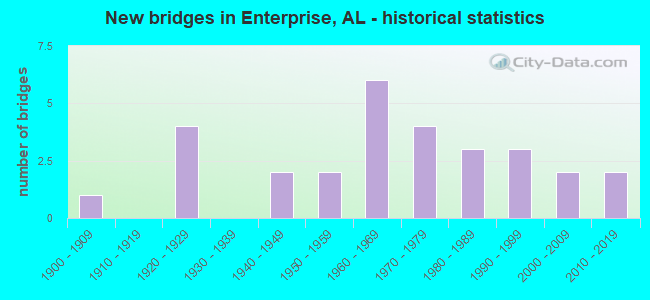
- New bridges - historical statistics
- 11900-1909
- 41920-1929
- 21940-1949
- 21950-1959
- 61960-1969
- 41970-1979
- 31980-1989
- 31990-1999
- 22000-2009
- 22010-2019
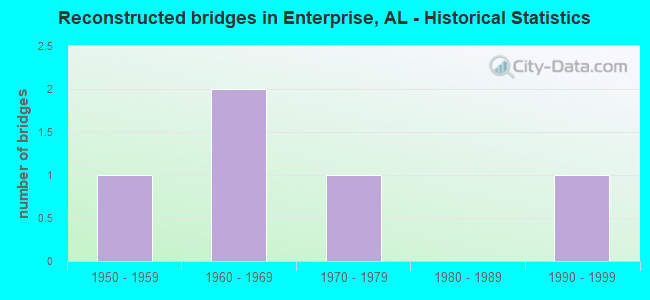
- Reconstructed bridges - Historical Statistics
- 11950-1959
- 21960-1969
- 11970-1979
- 01980-1989
- 11990-1999
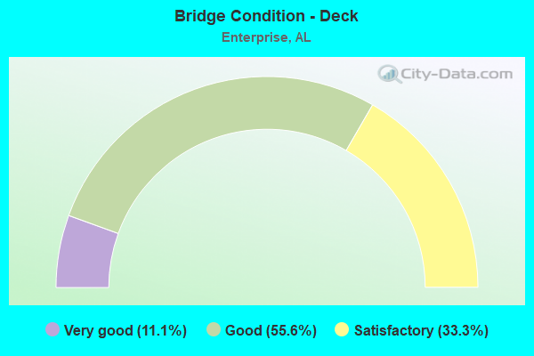
- Bridge Condition - Deck
- 11.1%Very good
- 55.6%Good
- 33.3%Satisfactory
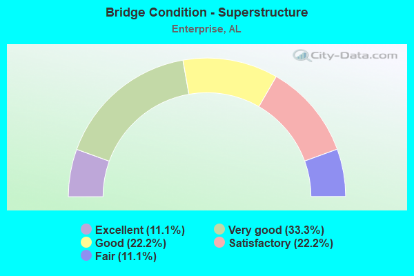
- Bridge Condition - Superstructure
- 11.1%Excellent
- 33.3%Very good
- 22.2%Good
- 22.2%Satisfactory
- 11.1%Fair
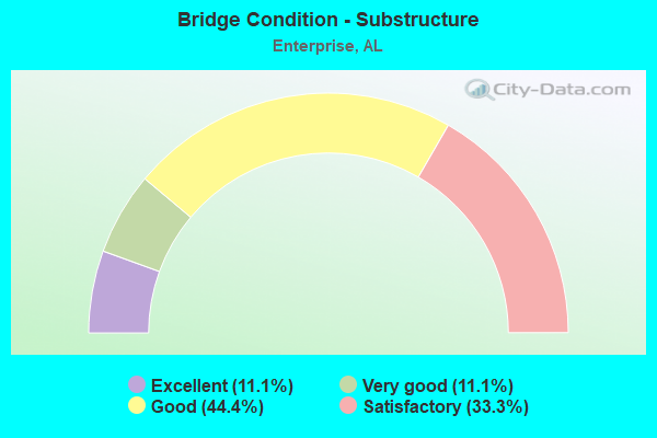
- Bridge Condition - Substructure
- 11.1%Excellent
- 11.1%Very good
- 44.4%Good
- 33.3%Satisfactory
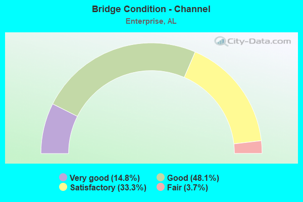
- Bridge Condition - Channel
- 14.8%Very good
- 48.1%Good
- 33.3%Satisfactory
- 3.7%Fair
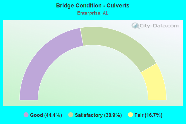
- Bridge Condition - Culverts
- 44.4%Good
- 38.9%Satisfactory
- 16.7%Fair
Find on map >> Show street view
Structure Number: 3344, Location: 6.9 MI. E. SR 87 (Lat: 31.315950, Lng: -85.918183), Route carried "on" structure: State highway 134, Year Built: 1948, Status: Open, Structure Length: 4.15m (13.62ft), Average Daily Traffic: 7,150 (year 2013), Truck Traffic: 8%, Average Future Daily Traffic: 10,296 (year 2033), Design Load: H 15, Features Intersected: DOUBLE BRIDGES CREEK
Minimum Vertical Clearance: 30+ m (98+ ft), Kilometerpoint: 35.322, Lanes on structure: 2, Owner: State Highway Agency, Approaching Roadway Width: 9.8m (32.2ft), Material/Design: Concrete, Design/Construction: Tee Beam, Number Of Spans In Main Unit: 4, Length of Maximum Span: 10.4m (34.1ft), Curb or Sidewalk Widths: Left: 0.3m (1.0ft), Right: 0.3m (1.0ft), Curb-To-Curb Width: 6.6m (21.7ft), Out-to-Out Width: 7.5m (24.6ft)
Condition: Deck: Satisfactory, Superstructure: Fair, Substructure: Satisfactory, Channel: Fair, Operating Rating: 38.6 metric tons, Method Used To Determine Operating Rating: Load Factor (LF), Inventory Rating: 23.1 metric tons, Method Used To Determine Inventory Rating: Load Factor (LF), Structural Evaluation: Somewhat better than minimum adequacy, Deck Geometry: High priority of replacement, Waterway Adequacy: Equal to present desirable criteria, Approach Roadway Alignment: Equal to present desirable criteria, Length Of Structure Improvement: 5.11m (16.77ft), Designated Inspection Frequency: Every 24 months, Inspection Date: May 2021, Bridge Improvement Cost: $841,000, Roadway Improvement Cost: $84,000, Total Project Cost: $925,000 ( Estimate for 2022), Deck Structure Type: Concrete Cast-file-Place
Find on map >> Show street view
Structure Number: 3345, Location: 0.699 MI INSIDE CR. (Lat: 31.322117, Lng: -85.878517), Route carried "on" structure: State highway 134, Year Built: 1948, Year Reconstructed: 2002, Status: Open, Structure Length: 1.01m (3.31ft), Average Daily Traffic: 3,380 (year 2013), Truck Traffic: 7%, Average Future Daily Traffic: 4,867 (year 2033), Design Load: H 15, Features Intersected: STREAM
Minimum Vertical Clearance: 30+ m (98+ ft), Kilometerpoint: 39.348, Lanes on structure: 2, Owner: State Highway Agency, Approaching Roadway Width: 10.7m (35.1ft), Skew: 3 degrees, Material/Design: Concrete, Design/Construction: Culvert, Number Of Spans In Main Unit: 3, Length of Maximum Span: 3.0m (9.8ft)
Condition: Channel: Satisfactory, Culverts: Satisfactory, Operating Rating: 60.1 metric tons, Method Used To Determine Operating Rating: Load Factor (LF), Inventory Rating: 36.1 metric tons, Method Used To Determine Inventory Rating: Load Factor (LF), Structural Evaluation: Equal to present minimum criteria, Waterway Adequacy: Equal to present desirable criteria, Approach Roadway Alignment: Equal to present desirable criteria, Length Of Structure Improvement: 1.68m (5.51ft), Designated Inspection Frequency: Every 24 months, Inspection Date: May 2021, Bridge Improvement Cost: $726,000, Roadway Improvement Cost: $73,000, Total Project Cost: $799,000 ( Estimate for 2022), Wearing Surface/Protective System: Wearing Surface: Bituminous
Find on map >> Show street view
Structure Number: 3827, Location: 2 MILES SOUTH OF KEYTON (Lat: 31.257344, Lng: -85.835658), Route carried "on" structure: County highway 712, Year Built: 1950, Status: Open, Structure Length: 0.67m (2.20ft), Average Daily Traffic: 577 (year 2020), Truck Traffic: 5%, Average Future Daily Traffic: 685 (year 2040), Design Load: H 15, Features Intersected: WILSONS MILL CREEK
Minimum Vertical Clearance: 30+ m (98+ ft), Kilometerpoint: 0.010, Lanes on structure: 2, Owner: County Highway Agency, Approaching Roadway Width: 9.1m (29.9ft), Material/Design: Concrete, Design/Construction: Culvert, Number Of Spans In Main Unit: 2, Length of Maximum Span: 3.0m (9.8ft)
Condition: Channel: Good, Culverts: Good, Operating Rating: 57.2 metric tons, Method Used To Determine Operating Rating: Load Factor (LF), Inventory Rating: 34.4 metric tons, Method Used To Determine Inventory Rating: Load Factor (LF), Structural Evaluation: Better than present minimum criteria, Waterway Adequacy: Better than present minimum criteria, Approach Roadway Alignment: Better than present minimum criteria, Length Of Structure Improvement: 1.30m (4.27ft), Designated Inspection Frequency: Every 24 months, Inspection Date: July 2020, Bridge Improvement Cost: $270,000, Roadway Improvement Cost: $27,000, Total Project Cost: $297,000 ( Estimate for 2022)
Find on map >> Show street view
Structure Number: 5183, Location: 2 MILE S.W.OF ENTERPRISE (Lat: 31.307150, Lng: -85.884033), Route carried "on" structure: City street , Year Built: 1955, Status: Open, Structure Length: 0.62m (2.03ft), Average Daily Traffic: 1,155 (year 2019), Truck Traffic: 15%, Average Future Daily Traffic: 1,610 (year 2039), Design Load: H 15, Features Intersected: BLANKET CREEK, Facility Carried by Structure: CO. RT. 606
Minimum Vertical Clearance: 30+ m (98+ ft), Kilometerpoint: 0.010, Lanes on structure: 2, Owner: City or Municipal Highway Agency, Approaching Roadway Width: 9.1m (29.9ft), Material/Design: Concrete, Design/Construction: Culvert, Number Of Spans In Main Unit: 2, Length of Maximum Span: 3.0m (9.8ft)
Condition: Channel: Satisfactory, Culverts: Satisfactory, Operating Rating: 71.4 metric tons, Method Used To Determine Operating Rating: Load Factor (LF), Inventory Rating: 42.8 metric tons, Method Used To Determine Inventory Rating: Load Factor (LF), Structural Evaluation: Equal to present minimum criteria, Waterway Adequacy: Somewhat better than minimum adequacy, Approach Roadway Alignment: Somewhat better than minimum adequacy, Length Of Structure Improvement: 1.24m (4.07ft), Designated Inspection Frequency: Every 24 months, Inspection Date: Febuary 2021, Bridge Improvement Cost: $230,000, Roadway Improvement Cost: $23,000, Total Project Cost: $253,000 ( Estimate for 2022)
Find on map >> Show street view
Structure Number: 643, Location: 1.25 MILES NW ROCK CITY (Lat: 33.991194, Lng: -87.726028), Route carried "on" structure: County highway 40, Year Built: 1900, Year Reconstructed: 1959, Status: Open, Structure Length: 1.95m (6.40ft), Average Daily Traffic: 500 (year 2001), Truck Traffic: 35%, Average Future Daily Traffic: 981 (year 2035), Design Load: HS 15, Features Intersected: Little New River
Minimum Vertical Clearance: 30+ m (98+ ft), Kilometerpoint: 0.010, Lanes on structure: 2, Owner: County Highway Agency, Approaching Roadway Width: 7.3m (24.0ft), Skew: 3 degrees, Material/Design: Concrete, Design/Construction: Culvert, Number Of Spans In Main Unit: 5, Length of Maximum Span: 3.7m (12.1ft), Curb-To-Curb Width: 7.9m (25.9ft), Out-to-Out Width: 8.4m (27.6ft)
Condition: Channel: Good, Culverts: Fair, Operating Rating: 39.3 metric tons, Method Used To Determine Operating Rating: Load Factor (LF), Inventory Rating: 23.5 metric tons, Method Used To Determine Inventory Rating: Load Factor (LF), Structural Evaluation: Somewhat better than minimum adequacy, Deck Geometry: Somewhat better than minimum adequacy, Waterway Adequacy: Equal to present minimum criteria, Approach Roadway Alignment: Better than present minimum criteria, Length Of Structure Improvement: 2.69m (8.83ft), Designated Inspection Frequency: Every 24 months, Inspection Date: Febuary 2021, Bridge Improvement Cost: $435,000, Roadway Improvement Cost: $44,000, Total Project Cost: $479,000 ( Estimate for 2022), Deck Structure Type: Concrete Cast-file-Place, Wearing Surface/Protective System: Wearing Surface: Bituminous
Find on map >> Show street view
Structure Number: 8811, Location: 1 MI E OF NEW HOME CH (Lat: 31.294928, Lng: -85.934364), Route carried "on" structure: County highway 620, Year Built: 1965, Status: Open, Structure Length: 0.67m (2.20ft), Average Daily Traffic: 176 (year 2020), Truck Traffic: 5%, Average Future Daily Traffic: 265 (year 2040), Design Load: H 15, Features Intersected: NEW HOME BRANCH
Minimum Vertical Clearance: 30+ m (98+ ft), Kilometerpoint: 0.010, Lanes on structure: 2, Owner: County Highway Agency, Approaching Roadway Width: 8.5m (27.9ft), Material/Design: Concrete, Design/Construction: Culvert, Number Of Spans In Main Unit: 2, Length of Maximum Span: 3.0m (9.8ft)
Condition: Channel: Good, Culverts: Satisfactory, Operating Rating: 87.5 metric tons, Method Used To Determine Operating Rating: Load Factor (LF), Inventory Rating: 52.5 metric tons, Method Used To Determine Inventory Rating: Load Factor (LF), Structural Evaluation: Equal to present minimum criteria, Waterway Adequacy: Better than present minimum criteria, Approach Roadway Alignment: Better than present minimum criteria, Length Of Structure Improvement: 1.30m (4.27ft), Designated Inspection Frequency: Every 24 months, Inspection Date: July 2020, Bridge Improvement Cost: $330,000, Roadway Improvement Cost: $33,000, Total Project Cost: $363,000 ( Estimate for 2022)
Find on map >> Show street view
Structure Number: 9143, Location: 5.7MILE S OF ENTERPRISE (Lat: 31.231444, Lng: -85.842847), Route carried "on" structure: County highway 723, Year Built: 1966, Status: Open, Structure Length: 1.98m (6.50ft), Average Daily Traffic: 294 (year 2020), Truck Traffic: 5%, Average Future Daily Traffic: 350 (year 2040), Design Load: H 10, Features Intersected: WILKERSON CREEK
Minimum Vertical Clearance: 30+ m (98+ ft), Kilometerpoint: 0.010, Lanes on structure: 2, Owner: County Highway Agency, Approaching Roadway Width: 9.8m (32.2ft), Material/Design: Concrete, Design/Construction: Culvert, Number Of Spans In Main Unit: 5, Length of Maximum Span: 3.7m (12.1ft)
Condition: Channel: Good, Culverts: Satisfactory, Operating Rating: 40.0 metric tons, Method Used To Determine Operating Rating: Load Factor (LF), Inventory Rating: 23.9 metric tons, Method Used To Determine Inventory Rating: Load Factor (LF), Structural Evaluation: Equal to present minimum criteria, Waterway Adequacy: Better than present minimum criteria, Approach Roadway Alignment: Equal to present desirable criteria, Length Of Structure Improvement: 2.73m (8.96ft), Designated Inspection Frequency: Every 24 months, Inspection Date: July 2020, Bridge Improvement Cost: $598,000, Roadway Improvement Cost: $60,000, Total Project Cost: $658,000 ( Estimate for 2022)
Find on map >> Show street view
Structure Number: 9418, Location: 4.27 MILE N.E.OF ENTERPRI (Lat: 31.345250, Lng: -85.814614), Route carried "on" structure: County highway 702, Year Built: 1967, Status: Open, Structure Length: 1.83m (6.00ft), Average Daily Traffic: 929 (year 2020), Truck Traffic: 5%, Average Future Daily Traffic: 1,245 (year 2040), Design Load: H 15, Features Intersected: HARRAND CREEK
Minimum Vertical Clearance: 30+ m (98+ ft), Kilometerpoint: 0.010, Lanes on structure: 2, Owner: County Highway Agency, Approaching Roadway Width: 10.4m (34.1ft), Skew: 3 degrees, Material/Design: Concrete, Design/Construction: Culvert, Number Of Spans In Main Unit: 4, Length of Maximum Span: 4.3m (14.1ft)
Condition: Channel: Good, Culverts: Fair, Operating Rating: 51.3 metric tons, Method Used To Determine Operating Rating: Load Factor (LF), Inventory Rating: 30.8 metric tons, Method Used To Determine Inventory Rating: Load Factor (LF), Structural Evaluation: Somewhat better than minimum adequacy, Waterway Adequacy: Better than present minimum criteria, Approach Roadway Alignment: Better than present minimum criteria, Length Of Structure Improvement: 2.54m (8.33ft), Designated Inspection Frequency: Every 24 months, Inspection Date: July 2020, Bridge Improvement Cost: $764,000, Roadway Improvement Cost: $76,000, Total Project Cost: $840,000 ( Estimate for 2022)
Find on map >> Show street view
Structure Number: 9488, Location: 2 MI. NORTH U.S. 84 (Lat: 31.354425, Lng: -85.833231), Route carried "on" structure: State highway 27, Year Built: 1928, Year Reconstructed: 1968, Status: Open, Structure Length: 0.98m (3.22ft), Average Daily Traffic: 5,240 (year 2013), Truck Traffic: 4%, Average Future Daily Traffic: 7,605 (year 2033), Design Load: H 15, Features Intersected: STRIPLING CREEK
Minimum Vertical Clearance: 30+ m (98+ ft), Kilometerpoint: 49.872, Lanes on structure: 4, Owner: State Highway Agency, Approaching Roadway Width: 18.3m (60.0ft), Material/Design: Concrete, Design/Construction: Culvert, Number Of Spans In Main Unit: 3, Length of Maximum Span: 3.0m (9.8ft)
Condition: Channel: Satisfactory, Culverts: Good, Operating Rating: 88.9 metric tons, Method Used To Determine Operating Rating: Load Factor (LF), Inventory Rating: 67.0 metric tons, Method Used To Determine Inventory Rating: Load Factor (LF), Structural Evaluation: Better than present minimum criteria, Waterway Adequacy: Equal to present desirable criteria, Approach Roadway Alignment: Equal to present desirable criteria, Length Of Structure Improvement: 1.65m (5.41ft), Designated Inspection Frequency: Every 24 months, Inspection Date: April 2020, Bridge Improvement Cost: $688,000, Roadway Improvement Cost: $69,000, Total Project Cost: $757,000 ( Estimate for 2022)
Find on map >> Show street view
Structure Number: 9489, Location: 2 MI. NORTH U.S. 84 (Lat: 31.354381, Lng: -85.833053), Route carried "on" structure: State highway 27, Year Built: 1929, Year Reconstructed: 1968, Status: Open, Structure Length: 0.76m (2.49ft), Average Daily Traffic: 5,240 (year 2013), Truck Traffic: 4%, Average Future Daily Traffic: 7,605 (year 2033), Design Load: H 15, Features Intersected: STRIPLING CREEK RELIEF
Minimum Vertical Clearance: 30+ m (98+ ft), Kilometerpoint: 49.848, Lanes on structure: 4, Owner: State Highway Agency, Approaching Roadway Width: 18.3m (60.0ft), Material/Design: Concrete, Design/Construction: Culvert, Number Of Spans In Main Unit: 3, Length of Maximum Span: 2.4m (7.9ft)
Condition: Channel: Satisfactory, Culverts: Satisfactory, Operating Rating: 88.9 metric tons, Method Used To Determine Operating Rating: Load Factor (LF), Inventory Rating: 55.7 metric tons, Method Used To Determine Inventory Rating: Load Factor (LF), Structural Evaluation: Equal to present minimum criteria, Waterway Adequacy: Equal to present desirable criteria, Approach Roadway Alignment: Equal to present minimum criteria, Length Of Structure Improvement: 1.41m (4.63ft), Designated Inspection Frequency: Every 24 months, Inspection Date: April 2020, Bridge Improvement Cost: $588,000, Roadway Improvement Cost: $59,000, Total Project Cost: $647,000 ( Estimate for 2022)
Find on map >> Show street view
Structure Number: 9937, Location: 4.08 MI S OF KEYTON (Lat: 31.237508, Lng: -85.822003), Route carried "on" structure: County highway 719, Year Built: 1969, Status: Open, Structure Length: 0.98m (3.22ft), Average Daily Traffic: 55 (year 2020), Average Future Daily Traffic: 95 (year 2040), Design Load: H 10, Features Intersected: WILSON MILL CREEK
Minimum Vertical Clearance: 30+ m (98+ ft), Kilometerpoint: 0.010, Lanes on structure: 2, Owner: County Highway Agency, Approaching Roadway Width: 9.1m (29.9ft), Material/Design: Concrete, Design/Construction: Culvert, Number Of Spans In Main Unit: 3, Length of Maximum Span: 3.0m (9.8ft)
Condition: Channel: Good, Culverts: Good, Operating Rating: 62.7 metric tons, Method Used To Determine Operating Rating: Load Factor (LF), Inventory Rating: 37.6 metric tons, Method Used To Determine Inventory Rating: Load Factor (LF), Structural Evaluation: Better than present minimum criteria, Waterway Adequacy: Better than present minimum criteria, Approach Roadway Alignment: Better than present minimum criteria, Length Of Structure Improvement: 1.65m (5.41ft), Designated Inspection Frequency: Every 24 months, Inspection Date: July 2020, Bridge Improvement Cost: $382,000, Roadway Improvement Cost: $38,000, Total Project Cost: $420,000 ( Estimate for 2022)
Find on map >> Show street view
Structure Number: 10314, Location: 2 MILES NW OF BATTENS XRD (Lat: 31.283203, Lng: -85.915964), Route carried "on" structure: County highway 610, Year Built: 1968, Status: Posted for load, Structure Length: 6.22m (20.41ft), Average Daily Traffic: 375 (year 2020), Truck Traffic: 5%, Average Future Daily Traffic: 495 (year 2040), Design Load: H 15, Features Intersected: DOUBLE BRIDGES CREEK
Minimum Vertical Clearance: 30+ m (98+ ft), Kilometerpoint: 0.010, Lanes on structure: 2, Owner: County Highway Agency, Approaching Roadway Width: 9.1m (29.9ft), Material/Design: Concrete, Design/Construction: Tee Beam, Number Of Spans In Main Unit: 6, Length of Maximum Span: 10.4m (34.1ft), Curb-To-Curb Width: 7.3m (24.0ft), Out-to-Out Width: 8.2m (26.9ft)
Condition: Deck: Satisfactory, Superstructure: Good, Substructure: Satisfactory, Channel: Satisfactory, Operating Rating: 34.7 metric tons, Method Used To Determine Operating Rating: Load Factor (LF), Inventory Rating: 20.8 metric tons, Method Used To Determine Inventory Rating: Load Factor (LF), Structural Evaluation: Equal to present minimum criteria, Deck Geometry: Somewhat better than minimum adequacy, Waterway Adequacy: Better than present minimum criteria, Approach Roadway Alignment: Better than present minimum criteria, Bridge Posting: Required (Relationship of Operating Rating to Maximum Legal Load: 10.0 - 19.9% below), Length Of Structure Improvement: 7.26m (23.82ft), Designated Inspection Frequency: Every 24 months, Other Special Inspection Frequency: Every 12 months, Inspection Date: May 2020, Other Special Inspection Date: May 2021, Bridge Improvement Cost: $1,295,000, Roadway Improvement Cost: $130,000, Total Project Cost: $1,425,000 ( Estimate for 2022), Deck Structure Type: Concrete Cast-file-Place
Find on map >> Show street view
Structure Number: 11146, Location: 3.95 MI S OF KEYTON (Lat: 31.228036, Lng: -85.842117), Route carried "on" structure: County highway 728, Year Built: 1974, Status: Open, Structure Length: 0.79m (2.59ft), Average Daily Traffic: 95 (year 2020), Average Future Daily Traffic: 135 (year 2040), Design Load: H 10, Features Intersected: SARDIS CREEK
Minimum Vertical Clearance: 30+ m (98+ ft), Kilometerpoint: 0.010, Lanes on structure: 2, Owner: County Highway Agency, Approaching Roadway Width: 9.1m (29.9ft), Skew: 3 degrees, Material/Design: Concrete, Design/Construction: Culvert, Number Of Spans In Main Unit: 2, Length of Maximum Span: 3.7m (12.1ft)
Condition: Channel: Good, Culverts: Good, Operating Rating: 88.9 metric tons, Method Used To Determine Operating Rating: Load Factor (LF), Inventory Rating: 69.4 metric tons, Method Used To Determine Inventory Rating: Load Factor (LF), Structural Evaluation: Better than present minimum criteria, Waterway Adequacy: Better than present minimum criteria, Approach Roadway Alignment: Better than present minimum criteria, Length Of Structure Improvement: 1.44m (4.72ft), Designated Inspection Frequency: Every 24 months, Inspection Date: July 2020, Bridge Improvement Cost: $433,000, Roadway Improvement Cost: $43,000, Total Project Cost: $476,000 ( Estimate for 2022)
Find on map >> Show street view
Structure Number: 11147, Location: 2.9 MI SE OF CLINTONVILLE (Lat: 31.388025, Lng: -85.849983), Route carried "on" structure: County highway 157, Year Built: 1974, Status: Open, Structure Length: 1.31m (4.30ft), Average Daily Traffic: 100 (year 2020), Average Future Daily Traffic: 165 (year 2040), Design Load: H 10, Features Intersected: MATTHEWS CREEK
Minimum Vertical Clearance: 30+ m (98+ ft), Kilometerpoint: 0.010, Lanes on structure: 2, Owner: County Highway Agency, Approaching Roadway Width: 8.5m (27.9ft), Material/Design: Concrete, Design/Construction: Culvert, Number Of Spans In Main Unit: 4, Length of Maximum Span: 3.0m (9.8ft)
Condition: Channel: Good, Culverts: Satisfactory, Operating Rating: 88.9 metric tons, Method Used To Determine Operating Rating: Load Factor (LF), Inventory Rating: 88.8 metric tons, Method Used To Determine Inventory Rating: Load Factor (LF), Structural Evaluation: Equal to present minimum criteria, Waterway Adequacy: Better than present minimum criteria, Approach Roadway Alignment: Better than present minimum criteria, Length Of Structure Improvement: 1.98m (6.50ft), Designated Inspection Frequency: Every 24 months, Inspection Date: July 2020, Bridge Improvement Cost: $665,000, Roadway Improvement Cost: $67,000, Total Project Cost: $732,000 ( Estimate for 2022)
Find on map >> Show street view
Structure Number: 11265, Location: 3.8 MILES WEST OF ENPRISE (Lat: 31.326128, Lng: -85.915656), Route carried "on" structure: County highway 537, Year Built: 1974, Status: Open, Structure Length: 4.05m (13.29ft), Average Daily Traffic: 55 (year 2020), Average Future Daily Traffic: 90 (year 2040), Design Load: H 15, Features Intersected: DOUBLE BRIDGES CREEK
Minimum Vertical Clearance: 30+ m (98+ ft), Kilometerpoint: 0.010, Lanes on structure: 2, Owner: County Highway Agency, Approaching Roadway Width: 9.1m (29.9ft), Material/Design: Concrete, Design/Construction: Channel Beam, Number Of Spans In Main Unit: 7, Length of Maximum Span: 5.8m (19.0ft), Curb-To-Curb Width: 7.3m (24.0ft), Out-to-Out Width: 8.2m (26.9ft)
Condition: Deck: Satisfactory, Superstructure: Satisfactory, Substructure: Satisfactory, Channel: Satisfactory, Operating Rating: 58.4 metric tons, Method Used To Determine Operating Rating: Allowable Stress (AS), Inventory Rating: 38.6 metric tons, Method Used To Determine Inventory Rating: Allowable Stress (AS), Structural Evaluation: Equal to present minimum criteria, Deck Geometry: Equal to present minimum criteria, Waterway Adequacy: Better than present minimum criteria, Approach Roadway Alignment: Better than present minimum criteria, Length Of Structure Improvement: 5.01m (16.44ft), Designated Inspection Frequency: Every 24 months, Underwater Inspection Frequency: Every 48 months, Inspection Date: May 2020, Underwater Inspection Date: September 2020, Bridge Improvement Cost: $894,000, Roadway Improvement Cost: $89,000, Total Project Cost: $983,000 ( Estimate for 2022), Deck Structure Type: Concrete Precast Panels
Find on map >> Show street view
Structure Number: 11593, Location: ENTERPRISE (Lat: 31.307200, Lng: -85.858750), Route carried "on" structure: City street , Year Built: 1976, Status: Open, Structure Length: 0.70m (2.30ft), Average Daily Traffic: 1,630 (year 2019), Truck Traffic: 1%, Average Future Daily Traffic: 2,060 (year 2039), Design Load: H 15, Features Intersected: STREAM, Facility Carried by Structure: DOSTER STREET
Minimum Vertical Clearance: 30+ m (98+ ft), Kilometerpoint: 0.539, Lanes on structure: 2, Owner: City or Municipal Highway Agency, Approaching Roadway Width: 9.9m (32.5ft), Skew: 4 degrees, Material/Design: Concrete, Design/Construction: Culvert, Number Of Spans In Main Unit: 2, Length of Maximum Span: 3.4m (11.2ft), Curb-To-Curb Width: 9.9m (32.5ft), Out-to-Out Width: 9.9m (32.5ft)
Condition: Channel: Good, Culverts: Good, Operating Rating: 68.9 metric tons, Method Used To Determine Operating Rating: Load Factor (LF), Inventory Rating: 41.4 metric tons, Method Used To Determine Inventory Rating: Load Factor (LF), Structural Evaluation: Better than present minimum criteria, Deck Geometry: Somewhat better than minimum adequacy, Waterway Adequacy: Equal to present minimum criteria, Approach Roadway Alignment: Equal to present minimum criteria, Length Of Structure Improvement: 1.34m (4.40ft), Designated Inspection Frequency: Every 24 months, Inspection Date: Febuary 2021, Bridge Improvement Cost: $518,000, Roadway Improvement Cost: $52,000, Total Project Cost: $570,000 ( Estimate for 2022)
Find on map >> Show street view
Structure Number: 12892, Location: 0.1 MI.E. SR 27 (Lat: 31.302697, Lng: -85.808886), Route carried "on" structure: US 84, Year Built: 1960, Year Reconstructed: 1982, Status: Open, Structure Length: 0.76m (2.49ft), Average Daily Traffic: 27,350 (year 2013), Truck Traffic: 4%, Average Future Daily Traffic: 36,692 (year 2033), Design Load: H 15, Features Intersected: BRANCH
Minimum Vertical Clearance: 30+ m (98+ ft), Kilometerpoint: 290.499, Lanes on structure: 6, Base Highway Network: Yes, Owner: State Highway Agency, Approaching Roadway Width: 26.2m (86.0ft), Material/Design: Concrete, Design/Construction: Culvert, Number Of Spans In Main Unit: 2, Length of Maximum Span: 3.7m (12.1ft)
Condition: Channel: Satisfactory, Culverts: Fair, Operating Rating: 88.9 metric tons, Method Used To Determine Operating Rating: Load Factor (LF), Inventory Rating: 88.9 metric tons, Method Used To Determine Inventory Rating: Load Factor (LF), Structural Evaluation: Somewhat better than minimum adequacy, Waterway Adequacy: Equal to present desirable criteria, Approach Roadway Alignment: Equal to present desirable criteria, Length Of Structure Improvement: 1.41m (4.63ft), Designated Inspection Frequency: Every 24 months, Inspection Date: Febuary 2022, Bridge Improvement Cost: $1,200,000, Roadway Improvement Cost: $120,000, Total Project Cost: $1,320,000 ( Estimate for 2022)
Find on map >> Show street view
Structure Number: 14283, Location: 0.3 MI. W.SR-167SOUTH (Lat: 31.293717, Lng: -85.836783), Route carried "on" structure: State highway 192, Year Built: 1987, Status: Open, Structure Length: 0.94m (3.08ft), Average Daily Traffic: 6,330 (year 2013), Truck Traffic: 6%, Average Future Daily Traffic: 7,878 (year 2033), Design Load: HS 20, Features Intersected: BRANCH
Minimum Vertical Clearance: 30+ m (98+ ft), Kilometerpoint: 0.470, Lanes on structure: 2, Owner: State Highway Agency, Approaching Roadway Width: 12.2m (40.0ft), Material/Design: Concrete, Design/Construction: Culvert, Number Of Spans In Main Unit: 3, Length of Maximum Span: 3.0m (9.8ft)
Condition: Channel: Satisfactory, Culverts: Good, Operating Rating: 88.9 metric tons, Method Used To Determine Operating Rating: Load Factor (LF), Inventory Rating: 88.9 metric tons, Method Used To Determine Inventory Rating: Load Factor (LF), Structural Evaluation: Better than present minimum criteria, Waterway Adequacy: Equal to present desirable criteria, Approach Roadway Alignment: Equal to present desirable criteria, Length Of Structure Improvement: 1.61m (5.28ft), Designated Inspection Frequency: Every 24 months, Inspection Date: August 2020, Bridge Improvement Cost: $2,506,000, Roadway Improvement Cost: $251,000, Total Project Cost: $2,757,000 ( Estimate for 2022)
Find on map >> Show street view
Structure Number: 14284, Location: 0.5 MI. W. US-84 (Lat: 31.331233, Lng: -85.874000), Route carried "on" structure: State highway 192, Year Built: 1987, Status: Open, Structure Length: 0.94m (3.08ft), Average Daily Traffic: 6,020 (year 2013), Truck Traffic: 9%, Average Future Daily Traffic: 7,492 (year 2033), Design Load: HS 20, Features Intersected: BRANCH
Minimum Vertical Clearance: 30+ m (98+ ft), Kilometerpoint: 9.917, Lanes on structure: 2, Owner: State Highway Agency, Approaching Roadway Width: 12.2m (40.0ft), Material/Design: Concrete, Design/Construction: Culvert, Number Of Spans In Main Unit: 3, Length of Maximum Span: 3.0m (9.8ft)
Condition: Channel: Good, Culverts: Good, Operating Rating: 88.9 metric tons, Method Used To Determine Operating Rating: Load Factor (LF), Inventory Rating: 88.9 metric tons, Method Used To Determine Inventory Rating: Load Factor (LF), Structural Evaluation: Better than present minimum criteria, Waterway Adequacy: Equal to present desirable criteria, Approach Roadway Alignment: Equal to present desirable criteria, Length Of Structure Improvement: 1.62m (5.31ft), Designated Inspection Frequency: Every 24 months, Inspection Date: August 2020, Bridge Improvement Cost: $4,991,000, Roadway Improvement Cost: $499,000, Total Project Cost: $5,490,000 ( Estimate for 2022)
Find on map >> Show street view
Structure Number: 14877, Location: 0.5 MI.N.COFFEE 156 (Lat: 31.385203, Lng: -85.809769), Route carried "on" structure: State highway 27, Year Built: 1989, Status: Open, Structure Length: 10.00m (32.81ft), Average Daily Traffic: 2,620 (year 2013), Truck Traffic: 11%, Average Future Daily Traffic: 3,803 (year 2033), Design Load: HS 20, Features Intersected: BOWLES CREEK
Minimum Vertical Clearance: 30+ m (98+ ft), Kilometerpoint: 54.098, Lanes on structure: 2, Owner: State Highway Agency, Approaching Roadway Width: 12.2m (40.0ft), Material/Design: Prestressed concrete continuous, Design/Construction: Stringer/Multi-beam, Number Of Spans In Main Unit: 8, Length of Maximum Span: 12.5m (41.0ft), Curb or Sidewalk Widths: Left: 0.2m (0.7ft), Right: 0.2m (0.7ft), Curb-To-Curb Width: 12.2m (40.0ft), Out-to-Out Width: 13.0m (42.7ft)
Condition: Deck: Good, Superstructure: Very good, Substructure: Good, Channel: Good, Operating Rating: 54.1 metric tons, Method Used To Determine Operating Rating: Load Factor (LF), Inventory Rating: 30.3 metric tons, Method Used To Determine Inventory Rating: Load Factor (LF), Structural Evaluation: Better than present minimum criteria, Deck Geometry: Equal to present minimum criteria, Waterway Adequacy: Equal to present desirable criteria, Approach Roadway Alignment: Equal to present desirable criteria, Length Of Structure Improvement: 10.93m (35.86ft), Designated Inspection Frequency: Every 24 months, Inspection Date: April 2020, Bridge Improvement Cost: $3,147,000, Roadway Improvement Cost: $315,000, Total Project Cost: $3,462,000 ( Estimate for 2022), Deck Structure Type: Concrete Cast-file-Place
Find on map >> Show street view
Structure Number: 15131, Location: ENTERPRISE (Lat: 31.331400, Lng: -85.829633), Route carried "on" structure: City street , Year Built: 1990, Status: Open, Structure Length: 1.46m (4.79ft), Average Daily Traffic: 1,210 (year 2019), Truck Traffic: 1%, Average Future Daily Traffic: 1,720 (year 2039), Design Load: HS 20, Features Intersected: STREAM, Facility Carried by Structure: DIXIE DRIVE
Minimum Vertical Clearance: 30+ m (98+ ft), Kilometerpoint: 0.620, Lanes on structure: 2, Owner: City or Municipal Highway Agency, Approaching Roadway Width: 8.9m (29.2ft), Material/Design: Concrete, Design/Construction: Channel Beam, Number Of Spans In Main Unit: 2, Length of Maximum Span: 7.3m (24.0ft), Curb or Sidewalk Widths: Left: 0.2m (0.7ft), Right: 0.2m (0.7ft), Curb-To-Curb Width: 8.8m (28.9ft), Out-to-Out Width: 9.3m (30.5ft)
Condition: Deck: Good, Superstructure: Satisfactory, Substructure: Good, Channel: Satisfactory, Operating Rating: 64.7 metric tons, Method Used To Determine Operating Rating: Load Factor (LF), Inventory Rating: 41.1 metric tons, Method Used To Determine Inventory Rating: Load Factor (LF), Structural Evaluation: Equal to present minimum criteria, Deck Geometry: Somewhat better than minimum adequacy, Waterway Adequacy: Somewhat better than minimum adequacy, Approach Roadway Alignment: Equal to present minimum criteria, Length Of Structure Improvement: 2.14m (7.02ft), Designated Inspection Frequency: Every 24 months, Inspection Date: Febuary 2021, Bridge Improvement Cost: $441,000, Roadway Improvement Cost: $44,000, Total Project Cost: $485,000 ( Estimate for 2022), Deck Structure Type: Concrete Precast Panels
Find on map >> Show street view
Structure Number: 15806, Location: 1.5 MI.E.SR 167 (Lat: 31.301617, Lng: -85.805217), Route carried "on" structure: US 84, Year Built: 1995, Status: Open, Structure Length: 1.83m (6.00ft), Average Daily Traffic: 17,100 (year 2013), Truck Traffic: 4%, Average Future Daily Traffic: 22,941 (year 2033), Design Load: HS 20, Features Intersected: COWPEN CREEK
Minimum Vertical Clearance: 30+ m (98+ ft), Kilometerpoint: 295.492, Lanes on structure: 4, Base Highway Network: Yes, Owner: State Highway Agency, Approaching Roadway Width: 24.4m (80.1ft), Skew: 11 degrees, Material/Design: Concrete, Design/Construction: Culvert, Number Of Spans In Main Unit: 4, Length of Maximum Span: 4.4m (14.4ft)
Condition: Channel: Good, Culverts: Satisfactory, Operating Rating: 88.9 metric tons, Method Used To Determine Operating Rating: Load Factor (LF), Inventory Rating: 88.9 metric tons, Method Used To Determine Inventory Rating: Load Factor (LF), Structural Evaluation: Equal to present minimum criteria, Waterway Adequacy: Equal to present desirable criteria, Approach Roadway Alignment: Equal to present desirable criteria, Length Of Structure Improvement: 2.54m (8.33ft), Designated Inspection Frequency: Every 24 months, Inspection Date: Febuary 2022, Bridge Improvement Cost: $2,556,000, Roadway Improvement Cost: $256,000, Total Project Cost: $2,812,000 ( Estimate for 2022)
Find on map >> Show street view
Structure Number: 15925, Location: 1.18 MI.W.OF SR.27 (Lat: 31.298314, Lng: -85.884019), Route carried "on" structure: State highway 192, Year Built: 1994, Status: Open, Structure Length: 5.18m (16.99ft), Average Daily Traffic: 3,840 (year 2013), Truck Traffic: 11%, Average Future Daily Traffic: 4,779 (year 2033), Design Load: HS 20, Features Intersected: BLANKET CREEK
Minimum Vertical Clearance: 30+ m (98+ ft), Kilometerpoint: 5.052, Lanes on structure: 2, Owner: State Highway Agency, Approaching Roadway Width: 13.7m (44.9ft), Material/Design: Prestressed concrete continuous, Design/Construction: Stringer/Multi-beam, Number Of Spans In Main Unit: 5, Length of Maximum Span: 10.4m (34.1ft), Curb-To-Curb Width: 12.2m (40.0ft), Out-to-Out Width: 13.0m (42.7ft)
Condition: Deck: Good, Superstructure: Good, Substructure: Good, Channel: Very good, Operating Rating: 52.4 metric tons, Method Used To Determine Operating Rating: Load Factor (LF), Inventory Rating: 31.4 metric tons, Method Used To Determine Inventory Rating: Load Factor (LF), Structural Evaluation: Better than present minimum criteria, Deck Geometry: Equal to present minimum criteria, Waterway Adequacy: Equal to present desirable criteria, Approach Roadway Alignment: Equal to present desirable criteria, Length Of Structure Improvement: 6.21m (20.37ft), Designated Inspection Frequency: Every 24 months, Inspection Date: August 2020, Bridge Improvement Cost: $1,787,000, Roadway Improvement Cost: $179,000, Total Project Cost: $1,966,000 ( Estimate for 2022), Deck Structure Type: Concrete Cast-file-Place
Find on map >> Show street view
Structure Number: 18963, Location: ENTERPRISE .26 FROM AL192 (Lat: 31.310417, Lng: -85.884250), Route carried "on" structure: Business City street , Year Built: 2002, Status: Open, Structure Length: 2.07m (6.79ft), Average Daily Traffic: 180 (year 2019), Average Future Daily Traffic: 260 (year 2039), Design Load: HS 20, Features Intersected: STREAM, Facility Carried by Structure: TARTAN WAY
Minimum Vertical Clearance: 30+ m (98+ ft), Kilometerpoint: 0.418, Lanes on structure: 2, Owner: City or Municipal Highway Agency, Approaching Roadway Width: 8.8m (28.9ft), Material/Design: Concrete, Design/Construction: Channel Beam, Number Of Spans In Main Unit: 2, Length of Maximum Span: 9.6m (31.5ft), Curb-To-Curb Width: 10.8m (35.4ft), Out-to-Out Width: 14.1m (46.3ft)
Condition: Deck: Very good, Superstructure: Very good, Substructure: Very good, Channel: Good, Operating Rating: 48.4 metric tons, Method Used To Determine Operating Rating: Load Factor (LF), Inventory Rating: 27.7 metric tons, Method Used To Determine Inventory Rating: Load Factor (LF), Structural Evaluation: Equal to present minimum criteria, Deck Geometry: Better than present minimum criteria, Waterway Adequacy: Equal to present minimum criteria, Approach Roadway Alignment: Equal to present minimum criteria, Length Of Structure Improvement: 2.84m (9.32ft), Designated Inspection Frequency: Every 24 months, Inspection Date: Febuary 2021, Bridge Improvement Cost: $896,000, Roadway Improvement Cost: $90,000, Total Project Cost: $986,000 ( Estimate for 2022), Deck Structure Type: Concrete Precast Panels
Find on map >> Show street view
Structure Number: 19494, Location: 4.64 MI SE NEW BROCKTON (Lat: 31.345236, Lng: -85.895878), Route carried "on" structure: County highway 520, Year Built: 2004, Status: Open, Structure Length: 2.07m (6.79ft), Average Daily Traffic: 100 (year 2020), Average Future Daily Traffic: 150 (year 2040), Design Load: HS 20, Features Intersected: LONGBRANCH CREEK
Minimum Vertical Clearance: 30+ m (98+ ft), Kilometerpoint: 0.000, Lanes on structure: 2, Owner: County Highway Agency, Approaching Roadway Width: 9.1m (29.9ft), Material/Design: Concrete, Design/Construction: Channel Beam, Number Of Spans In Main Unit: 2, Length of Maximum Span: 10.4m (34.1ft), Curb-To-Curb Width: 8.5m (27.9ft), Out-to-Out Width: 9.3m (30.5ft)
Condition: Deck: Good, Superstructure: Very good, Substructure: Good, Channel: Very good, Operating Rating: 74.1 metric tons, Method Used To Determine Operating Rating: Load Factor (LF), Inventory Rating: 44.5 metric tons, Method Used To Determine Inventory Rating: Load Factor (LF), Structural Evaluation: Better than present minimum criteria, Waterway Adequacy: Better than present minimum criteria, Approach Roadway Alignment: Equal to present minimum criteria, Length Of Structure Improvement: 2.84m (9.32ft), Designated Inspection Frequency: Every 24 months, Inspection Date: May 2020, Bridge Improvement Cost: $584,000, Roadway Improvement Cost: $58,000, Total Project Cost: $642,000 ( Estimate for 2022), Deck Structure Type: Concrete Precast Panels
Find on map >> Show street view
Structure Number: 20494, Location: 2 MI. E. OF SR 122 (Lat: 31.360361, Lng: -85.887861), Route carried "on" structure: US 84, Year Built: 2012, Status: Open, Structure Length: 0.90m (2.95ft), Average Daily Traffic: 4,870 (year 2011), Truck Traffic: 8%, Average Future Daily Traffic: 7,980 (year 2031), Design Load: HS 20, Features Intersected: LONG BRANCH CREEK, Facility Carried by Structure: SR-12 MP 576.593
Minimum Vertical Clearance: 30+ m (98+ ft), Kilometerpoint: 283.920, Lanes on structure: 2, Base Highway Network: Yes, Owner: State Highway Agency, Approaching Roadway Width: 15.2m (49.9ft), Skew: 3 degrees, Material/Design: Concrete, Design/Construction: Culvert, Number Of Spans In Main Unit: 2, Length of Maximum Span: 4.2m (13.8ft)
Condition: Channel: Very good, Culverts: Good, Operating Rating: 88.9 metric tons, Method Used To Determine Operating Rating: Load Factor (LF), Inventory Rating: 88.9 metric tons, Method Used To Determine Inventory Rating: Load Factor (LF), Structural Evaluation: Better than present minimum criteria, Waterway Adequacy: Equal to present desirable criteria, Approach Roadway Alignment: Equal to present desirable criteria, Length Of Structure Improvement: 1.57m (5.15ft), Designated Inspection Frequency: Every 24 months, Inspection Date: March 2022, Bridge Improvement Cost: $2,568,000, Roadway Improvement Cost: $257,000, Total Project Cost: $2,825,000 ( Estimate for 2022)
Find on map >> Show street view
Structure Number: 20801, Location: ENTERPRISE (Lat: 31.344533, Lng: -85.852683), Route carried "on" structure: City street , Year Built: 2013, Status: Open, Structure Length: 1.04m (3.41ft), Average Daily Traffic: 1,160 (year 2019), Average Future Daily Traffic: 1,620 (year 2039), Design Load: HS 20, Features Intersected: STREAM, Facility Carried by Structure: NORTHSIDE DRIVE
Minimum Vertical Clearance: 30+ m (98+ ft), Kilometerpoint: 0.418, Lanes on structure: 2, Owner: City or Municipal Highway Agency, Approaching Roadway Width: 10.7m (35.1ft), Material/Design: Concrete, Design/Construction: Channel Beam, Number Of Spans In Main Unit: 1, Length of Maximum Span: 10.4m (34.1ft), Curb-To-Curb Width: 10.7m (35.1ft), Out-to-Out Width: 11.5m (37.7ft)
Condition: Deck: Good, Superstructure: Excellent, Substructure: Excellent, Channel: Very good, Operating Rating: 72.1 metric tons, Method Used To Determine Operating Rating: Load Factor (LF), Inventory Rating: 43.3 metric tons, Method Used To Determine Inventory Rating: Load Factor (LF), Structural Evaluation: Superior to present desirable criteria, Deck Geometry: Equal to present minimum criteria, Waterway Adequacy: Equal to present minimum criteria, Approach Roadway Alignment: Equal to present minimum criteria, Length Of Structure Improvement: 1.71m (5.61ft), Designated Inspection Frequency: Every 24 months, Inspection Date: Febuary 2021, Bridge Improvement Cost: $433,000, Roadway Improvement Cost: $43,000, Total Project Cost: $476,000 ( Estimate for 2022), Deck Structure Type: Concrete Precast Panels
Find on map >> Show street view
Structure Number: 643, Location: JCT. SR 88 (Lat: 31.311244, Lng: -85.851497), Route carried "under" structure: State highway 27, Year Built: 1929, Structure Length: 0. m, Average Daily Traffic: 9,440 (year 2013), Truck Traffic: 6%, Features Intersected: S. R. 27, Facility Carried by Structure: WIREGRASS C RR
Minimum Vertical Clearance: 4.34m (14.24ft), Kilometerpoint: 44.020, Lanes under structure: 2, Material/Design: Steel, Design/Construction: Truss - Thru, Length of Maximum Span: 28.0m (91.9ft)
Find on map >> Show street view
Structure Number: 688, Location: CITY OF ENTERPRISE (Lat: 31.320467, Lng: -85.859917), Route carried "under" structure: State highway 134, Year Built: 1929, Structure Length: 0. m, Average Daily Traffic: 4,220 (year 2013), Truck Traffic: 4%, Features Intersected: S. R. 134, Facility Carried by Structure: WIREGRASS C RR
Minimum Vertical Clearance: 4.27m (14.01ft), Kilometerpoint: 41.310, Lanes under structure: 2, Material/Design: Steel, Design/Construction: Stringer/Multi-beam, Length of Maximum Span: 11.9m (39.0ft)