Bridge Statistics for Englewood, New Jersey (NJ)
Condition, Traffic, Stress, Structural Evaluation, Project Costs
- National Bridge Inventory (NBI) Statistics
- 34Number of bridges
- 308ft / 94.5mTotal length
- $9,067,000Total costs
- 1,139,005Total average daily traffic
- 84,772Total average daily truck traffic
- National Bridge Inventory (NBI) Registered Bridges for Englewood
- No street view available for this location
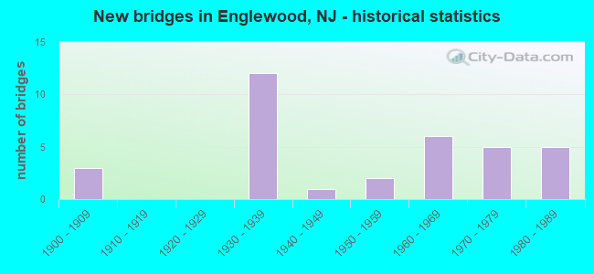
- New bridges - historical statistics
- 31900-1909
- 121930-1939
- 11940-1949
- 21950-1959
- 61960-1969
- 51970-1979
- 51980-1989

- Reconstructed bridges - Historical Statistics
- 31960-1969
- 11970-1979
- 21980-1989
- 11990-1999
- 22000-2009


- Bridge Condition - Deck
- 9.1%Very good
- 13.6%Good
- 40.9%Satisfactory
- 27.3%Fair
- 9.1%Poor

- Bridge Condition - Superstructure
- 4.5%Very good
- 22.7%Good
- 22.7%Satisfactory
- 45.5%Fair
- 4.5%Poor

- Bridge Condition - Substructure
- 31.8%Good
- 36.4%Satisfactory
- 31.8%Fair

- Bridge Condition - Channel
- 9.1%Very good
- 36.4%Good
- 27.3%Satisfactory
- 27.3%Fair

- Bridge Condition - Culverts
- 60.0%Good
- 40.0%Satisfactory
Find on map >> Show street view
Structure Number: 20015A, Location: 0.28 Mi S of Ivy Ln (Lat: 40.906539, Lng: -73.969139), Route carried "on" structure: City street 501, Year Built: 1951, Status: Posted for load, Structure Length: 1.10m (3.61ft), Average Daily Traffic: 5,748 (year 2020), Truck Traffic: 4%, Average Future Daily Traffic: 7,014 (year 2040), Features Intersected: OVERPECK CREEK, Facility Carried by Structure: NORTH DEAN STREET
Minimum Vertical Clearance: 30+ m (98+ ft), Kilometerpoint: 72.260, Lanes on structure: 2, Base Highway Network: Yes, Owner: County Highway Agency, Approaching Roadway Width: 9.1m (29.9ft), Material/Design: Steel, Design/Construction: Stringer/Multi-beam, Number Of Spans In Main Unit: 1, Length of Maximum Span: 9.8m (32.2ft), Curb or Sidewalk Widths: Left: 0.0m, Right: 0.8m (2.6ft), Curb-To-Curb Width: 9.1m (29.9ft), Out-to-Out Width: 10.9m (35.8ft)
Condition: Deck: Satisfactory, Superstructure: Good, Substructure: Fair, Channel: Fair, Operating Rating: 28.1 metric tons, Method Used To Determine Operating Rating: Load Factor (LF), Inventory Rating: 16.3 metric tons, Method Used To Determine Inventory Rating: Load Factor (LF), Structural Evaluation: Meets minimum limits, Deck Geometry: Meets minimum limits, Waterway Adequacy: Superior to present desirable criteria, Approach Roadway Alignment: Equal to present desirable criteria, Bridge Posting: Required (Relationship of Operating Rating to Maximum Legal Load: 0.1 - 9.9% below), Length Of Structure Improvement: 1.10m (3.61ft), Designated Inspection Frequency: Every 24 months, Other Special Inspection Frequency: Every 12 months, Inspection Date: May 2020, Other Special Inspection Date: May 2021, Bridge Improvement Cost: $166,000, Total Project Cost: $207,000 ( Estimate for 2020), Deck Structure Type: Concrete Cast-file-Place, Wearing Surface/Protective System: Wearing Surface: Bituminous
Find on map >> Show street view
Structure Number: 20015B, Location: 100 FT N OF I-95 UNDERPSS (Lat: 40.872881, Lng: -73.979769), Route carried "on" structure: City street , Year Built: 1976, Status: Open, Structure Length: 0.98m (3.22ft), Average Daily Traffic: 21,299 (year 2020), Truck Traffic: 4%, Average Future Daily Traffic: 25,989 (year 2040), Features Intersected: FLAT ROCK BROOK, Facility Carried by Structure: BROAD AVENUE
Minimum Vertical Clearance: 30+ m (98+ ft), Kilometerpoint: 3.798, Lanes on structure: 2, Owner: County Highway Agency, Approaching Roadway Width: 14.6m (47.9ft), Skew: 2 degrees, Material/Design: Prestressed concrete, Design/Construction: Slab, Number Of Spans In Main Unit: 1, Length of Maximum Span: 8.8m (28.9ft), Curb or Sidewalk Widths: Left: 3.0m (9.8ft), Right: 1.4m (4.6ft), Curb-To-Curb Width: 14.7m (48.2ft), Out-to-Out Width: 19.8m (65.0ft)
Condition: Deck: Fair, Superstructure: Fair, Substructure: Satisfactory, Channel: Good, Operating Rating: 56.2 metric tons, Method Used To Determine Operating Rating: Load Factor (LF), Inventory Rating: 33.6 metric tons, Method Used To Determine Inventory Rating: Load Factor (LF), Structural Evaluation: Somewhat better than minimum adequacy, Deck Geometry: Superior to present desirable criteria, Waterway Adequacy: Superior to present desirable criteria, Approach Roadway Alignment: Equal to present desirable criteria, Designated Inspection Frequency: Every 24 months, Inspection Date: April 2020, Deck Structure Type: Concrete Precast Panels, Wearing Surface/Protective System: Wearing Surface: Bituminous
Find on map >> Show street view
Structure Number: 20015C, Location: 0.35 MI W. OF CR 501 (Lat: 40.894269, Lng: -73.979511), Route carried "on" structure: City street , Year Built: 1909, Year Reconstructed: 2001, Status: Open, Structure Length: 0.70m (2.30ft), Average Daily Traffic: 14,030 (year 2020), Truck Traffic: 3%, Average Future Daily Traffic: 17,119 (year 2040), Design Load: HS 25 or greater, Features Intersected: OVERPECK CREEK, Facility Carried by Structure: ENGLEWOOD AVE
Minimum Vertical Clearance: 30+ m (98+ ft), Kilometerpoint: 0.306, Lanes on structure: 2, Owner: County Highway Agency, Approaching Roadway Width: 10.4m (34.1ft), Skew: 1 degrees, Material/Design: Prestressed concrete, Design/Construction: Slab, Number Of Spans In Main Unit: 1, Length of Maximum Span: 6.7m (22.0ft), Curb or Sidewalk Widths: Left: 1.9m (6.2ft), Right: 2.1m (6.9ft), Curb-To-Curb Width: 10.4m (34.1ft), Out-to-Out Width: 15.0m (49.2ft)
Condition: Deck: Good, Superstructure: Good, Substructure: Good, Channel: Good, Operating Rating: 88.9 metric tons, Method Used To Determine Operating Rating: Load Factor (LF), Inventory Rating: 53.5 metric tons, Method Used To Determine Inventory Rating: Load Factor (LF), Structural Evaluation: Better than present minimum criteria, Deck Geometry: Meets minimum limits, Waterway Adequacy: Better than present minimum criteria, Approach Roadway Alignment: Equal to present desirable criteria, Designated Inspection Frequency: Every 24 months, Inspection Date: May 2020, Deck Structure Type: Concrete Cast-file-Place, Wearing Surface/Protective System: Wearing Surface: Monolithic Concrete, Deck Protection: Epoxy Coated Reinforcing
Find on map >> Show street view
Structure Number: 20015D, Location: 0.48 MI W OF GRAND AVENUE (Lat: 40.887800, Lng: -73.985361), Route carried "on" structure: County highway 64, Year Built: 1954, Year Reconstructed: 1981, Status: Open, Structure Length: 2.13m (6.99ft), Average Daily Traffic: 7,381 (year 2020), Truck Traffic: 4%, Average Future Daily Traffic: 9,006 (year 2040), Design Load: HS 20+Mod, Features Intersected: OVERPECK CREEK
Minimum Vertical Clearance: 30+ m (98+ ft), Kilometerpoint: 1.561, Lanes on structure: 2, Owner: County Highway Agency, Approaching Roadway Width: 12.2m (40.0ft), Material/Design: Steel, Design/Construction: Stringer/Multi-beam, Number Of Spans In Main Unit: 2, Length of Maximum Span: 12.5m (41.0ft), Curb or Sidewalk Widths: Left: 2.1m (6.9ft), Right: 2.7m (8.9ft), Curb-To-Curb Width: 12.2m (40.0ft), Out-to-Out Width: 17.6m (57.7ft)
Condition: Deck: Satisfactory, Superstructure: Fair, Substructure: Satisfactory, Channel: Satisfactory, Operating Rating: 36.3 metric tons, Method Used To Determine Operating Rating: Load Factor (LF), Inventory Rating: 21.8 metric tons, Method Used To Determine Inventory Rating: Load Factor (LF), Structural Evaluation: Somewhat better than minimum adequacy, Deck Geometry: Somewhat better than minimum adequacy, Waterway Adequacy: Somewhat better than minimum adequacy, Approach Roadway Alignment: Better than present minimum criteria, Designated Inspection Frequency: Every 24 months, Inspection Date: May 2020, Deck Structure Type: Concrete Cast-file-Place, Wearing Surface/Protective System: Wearing Surface: Bituminous
Find on map >> Show street view
Structure Number: 20015E, Location: 0.2 MI W. OF CR 501 (Lat: 40.902281, Lng: -73.972139), Route carried "on" structure: City street , Year Built: 1906, Year Reconstructed: 1974, Status: Open, Structure Length: 0.82m (2.69ft), Average Daily Traffic: 1,385 (year 2020), Truck Traffic: 3%, Average Future Daily Traffic: 1,690 (year 2040), Design Load: HS 20, Features Intersected: OVERPECK CREEK, Facility Carried by Structure: HAMILTON AVE
Minimum Vertical Clearance: 30+ m (98+ ft), Kilometerpoint: 0.338, Lanes on structure: 2, Owner: County Highway Agency, Approaching Roadway Width: 9.1m (29.9ft), Skew: 2 degrees, Material/Design: Prestressed concrete, Design/Construction: Slab, Number Of Spans In Main Unit: 1, Length of Maximum Span: 7.0m (23.0ft), Curb or Sidewalk Widths: Left: 2.7m (8.9ft), Right: 3.1m (10.2ft), Curb-To-Curb Width: 9.2m (30.2ft), Out-to-Out Width: 15.6m (51.2ft)
Condition: Deck: Fair, Superstructure: Fair, Substructure: Fair, Channel: Fair, Operating Rating: 40.8 metric tons, Method Used To Determine Operating Rating: Load Factor (LF), Inventory Rating: 24.5 metric tons, Method Used To Determine Inventory Rating: Load Factor (LF), Structural Evaluation: Somewhat better than minimum adequacy, Deck Geometry: Somewhat better than minimum adequacy, Waterway Adequacy: Equal to present desirable criteria, Approach Roadway Alignment: Equal to present desirable criteria, Length Of Structure Improvement: 0.61m (2.00ft), Designated Inspection Frequency: Every 24 months, Inspection Date: May 2020, Bridge Improvement Cost: $28,000, Total Project Cost: $29,000 ( Estimate for 2020), Deck Structure Type: Concrete Precast Panels, Wearing Surface/Protective System: Wearing Surface: Bituminous
Find on map >> Show street view
Structure Number: 20015F, Location: 0.34 MI N. OF RT 501 (Lat: 40.895561, Lng: -73.977689), Route carried "on" structure: County highway 505, Year Built: 1948, Year Reconstructed: 1974, Status: Open, Structure Length: 1.04m (3.41ft), Average Daily Traffic: 7,195 (year 2020), Truck Traffic: 4%, Average Future Daily Traffic: 8,780 (year 2040), Features Intersected: OVERPECK CREEK
Minimum Vertical Clearance: 30+ m (98+ ft), Kilometerpoint: 18.250, Lanes on structure: 2, Base Highway Network: Yes, Owner: County Highway Agency, Approaching Roadway Width: 20.7m (67.9ft), Skew: 3 degrees, Material/Design: Concrete continuous, Design/Construction: Culvert, Number Of Spans In Main Unit: 2, Length of Maximum Span: 5.8m (19.0ft), Curb or Sidewalk Widths: Left: 4.7m (15.4ft), Right: 4.7m (15.4ft), Curb-To-Curb Width: 20.7m (67.9ft), Out-to-Out Width: 30.2m (99.1ft)
Condition: Channel: Good, Culverts: Satisfactory, Operating Rating: 29.9 metric tons, Method Used To Determine Operating Rating: Load Factor (LF), Inventory Rating: 18.1 metric tons, Method Used To Determine Inventory Rating: Load Factor (LF), Structural Evaluation: Meets minimum limits, Deck Geometry: Superior to present desirable criteria, Waterway Adequacy: Equal to present minimum criteria, Approach Roadway Alignment: Better than present minimum criteria, Designated Inspection Frequency: Every 24 months, Underwater Inspection Frequency: Every 24 months, Inspection Date: May 2020, Underwater Inspection Date: September 2020, Deck Structure Type: Concrete Cast-file-Place, Wearing Surface/Protective System: Wearing Surface: Bituminous
Find on map >> Show street view
Structure Number: 20015G, Location: Adjacent to NJ RTE 4 (Lat: 40.874681, Lng: -73.972900), Route carried "on" structure: City street , Year Built: 1975, Status: Open, Structure Length: 1.16m (3.81ft), Average Daily Traffic: 640 (year 2020), Truck Traffic: 1%, Average Future Daily Traffic: 768 (year 2040), Design Load: HS 20+Mod, Features Intersected: FLAT ROCK BROOK, Facility Carried by Structure: WALTON STREET
Minimum Vertical Clearance: 30+ m (98+ ft), Kilometerpoint: 0.000, Lanes on structure: 2, Owner: County Highway Agency, Approaching Roadway Width: 7.6m (24.9ft), Skew: 3 degrees, Material/Design: Prestressed concrete, Design/Construction: Box Beam or Girders - Multiple, Number Of Spans In Main Unit: 1, Length of Maximum Span: 11.0m (36.1ft), Curb or Sidewalk Widths: Left: 1.5m (4.9ft), Right: 0.5m (1.6ft), Curb-To-Curb Width: 7.9m (25.9ft), Out-to-Out Width: 10.7m (35.1ft)
Condition: Deck: Very good, Superstructure: Good, Substructure: Good, Channel: Fair, Operating Rating: 44.5 metric tons, Method Used To Determine Operating Rating: Load Factor (LF), Inventory Rating: 26.3 metric tons, Method Used To Determine Inventory Rating: Load Factor (LF), Structural Evaluation: Equal to present minimum criteria, Deck Geometry: Somewhat better than minimum adequacy, Waterway Adequacy: Superior to present desirable criteria, Approach Roadway Alignment: Better than present minimum criteria, Designated Inspection Frequency: Every 24 months, Inspection Date: April 2020, Deck Structure Type: Concrete Precast Panels, Wearing Surface/Protective System: Wearing Surface: Bituminous
Find on map >> Show street view
Structure Number: 20015H, Location: 0.1 Mi. N OF NJ 4 (Lat: 40.874539, Lng: -73.972331), Route carried "on" structure: City street , Year Built: 1968, Status: Open, Structure Length: 0.91m (2.99ft), Average Daily Traffic: 10,889 (year 2020), Truck Traffic: 3%, Average Future Daily Traffic: 13,420 (year 2040), Design Load: H 20, Features Intersected: FLAT ROCK BROOK, Facility Carried by Structure: JONES ROAD
Minimum Vertical Clearance: 30+ m (98+ ft), Kilometerpoint: 0.563, Lanes on structure: 2, Owner: County Highway Agency, Approaching Roadway Width: 10.7m (35.1ft), Skew: 1 degrees, Material/Design: Prestressed concrete, Design/Construction: Slab, Number Of Spans In Main Unit: 1, Length of Maximum Span: 8.2m (26.9ft), Curb or Sidewalk Widths: Left: 2.5m (8.2ft), Right: 2.5m (8.2ft), Curb-To-Curb Width: 10.9m (35.8ft), Out-to-Out Width: 16.5m (54.1ft)
Condition: Deck: Satisfactory, Superstructure: Satisfactory, Substructure: Satisfactory, Channel: Fair, Operating Rating: 50.8 metric tons, Method Used To Determine Operating Rating: Load Factor (LF), Inventory Rating: 30.8 metric tons, Method Used To Determine Inventory Rating: Load Factor (LF), Structural Evaluation: Equal to present minimum criteria, Deck Geometry: Meets minimum limits, Waterway Adequacy: Equal to present minimum criteria, Approach Roadway Alignment: Equal to present desirable criteria, Designated Inspection Frequency: Every 24 months, Inspection Date: May 2020, Deck Structure Type: Concrete Cast-file-Place, Wearing Surface/Protective System: Wearing Surface: Bituminous
Find on map >> Show street view
Structure Number: 20015J, Location: .15 Mi. E. of 4th Street (Lat: 40.889400, Lng: -73.984039), Route carried "on" structure: City street , Year Built: 1971, Status: Open, Structure Length: 0.79m (2.59ft), Average Daily Traffic: 1,401 (year 2020), Truck Traffic: 1%, Average Future Daily Traffic: 1,681 (year 2040), Features Intersected: OVERPECK CREEK, Facility Carried by Structure: FIRST STREET
Minimum Vertical Clearance: 30+ m (98+ ft), Kilometerpoint: 0.000, Lanes on structure: 2, Owner: County Highway Agency, Approaching Roadway Width: 7.3m (24.0ft), Material/Design: Prestressed concrete, Design/Construction: Slab, Number Of Spans In Main Unit: 1, Length of Maximum Span: 6.7m (22.0ft), Curb or Sidewalk Widths: Left: 2.1m (6.9ft), Right: 2.1m (6.9ft), Curb-To-Curb Width: 7.3m (24.0ft), Out-to-Out Width: 12.3m (40.4ft)
Condition: Deck: Good, Superstructure: Satisfactory, Substructure: Good, Channel: Fair, Operating Rating: 46.3 metric tons, Method Used To Determine Operating Rating: Load Factor (LF), Inventory Rating: 28.1 metric tons, Method Used To Determine Inventory Rating: Load Factor (LF), Structural Evaluation: Equal to present minimum criteria, Deck Geometry: Meets minimum limits, Waterway Adequacy: Equal to present desirable criteria, Approach Roadway Alignment: Equal to present desirable criteria, Designated Inspection Frequency: Every 24 months, Inspection Date: April 2020, Deck Structure Type: Concrete Precast Panels, Wearing Surface/Protective System: Wearing Surface: Bituminous
Find on map >> Show street view
Structure Number: 20015K, Location: 0.5 MI N OF NJ RTE 4 (Lat: 40.889500, Lng: -73.984300), Route carried "on" structure: City street , Year Built: 1971, Status: Open, Structure Length: 1.22m (4.00ft), Average Daily Traffic: 1,428 (year 2020), Truck Traffic: 1%, Average Future Daily Traffic: 1,714 (year 2040), Design Load: HS 20, Features Intersected: METZLERS BROOK, Facility Carried by Structure: FIRST STREET
Minimum Vertical Clearance: 30+ m (98+ ft), Kilometerpoint: 0.000, Lanes on structure: 2, Owner: County Highway Agency, Approaching Roadway Width: 7.3m (24.0ft), Skew: 2 degrees, Material/Design: Prestressed concrete, Design/Construction: Slab, Number Of Spans In Main Unit: 1, Length of Maximum Span: 10.4m (34.1ft), Curb or Sidewalk Widths: Left: 2.1m (6.9ft), Right: 2.1m (6.9ft), Curb-To-Curb Width: 7.4m (24.3ft), Out-to-Out Width: 12.2m (40.0ft)
Condition: Deck: Satisfactory, Superstructure: Fair, Substructure: Good, Channel: Good, Operating Rating: 54.4 metric tons, Method Used To Determine Operating Rating: Field evaluation and documented engineering judgment, Inventory Rating: 32.7 metric tons, Method Used To Determine Inventory Rating: Field evaluation and documented engineering judgment, Structural Evaluation: Somewhat better than minimum adequacy, Deck Geometry: Meets minimum limits, Waterway Adequacy: Equal to present desirable criteria, Approach Roadway Alignment: Equal to present desirable criteria, Designated Inspection Frequency: Every 24 months, Inspection Date: April 2020, Deck Structure Type: Concrete Precast Panels, Wearing Surface/Protective System: Wearing Surface: Bituminous
Find on map >> Show street view
Structure Number: 20015L, Location: 0.04 Mi W. of Brookway Av (Lat: 40.896189, Lng: -73.984869), Route carried "on" structure: County highway S37, Year Built: 1974, Status: Open, Structure Length: 1.13m (3.71ft), Average Daily Traffic: 15,189 (year 2020), Truck Traffic: 4%, Average Future Daily Traffic: 18,533 (year 2040), Design Load: HS 20+Mod, Features Intersected: METZLER'S BROOK
Minimum Vertical Clearance: 30+ m (98+ ft), Kilometerpoint: 0.064, Lanes on structure: 3, Owner: County Highway Agency, Approaching Roadway Width: 16.2m (53.1ft), Skew: 1 degrees, Material/Design: Steel, Design/Construction: Stringer/Multi-beam, Number Of Spans In Main Unit: 1, Length of Maximum Span: 9.1m (29.9ft), Curb or Sidewalk Widths: Left: 1.5m (4.9ft), Right: 1.5m (4.9ft), Curb-To-Curb Width: 16.2m (53.1ft), Out-to-Out Width: 19.9m (65.3ft)
Condition: Deck: Satisfactory, Superstructure: Good, Substructure: Good, Channel: Good, Inventory Rating: 69.9 metric tons, Method Used To Determine Inventory Rating: Load Factor (LF), Structural Evaluation: Better than present minimum criteria, Deck Geometry: Better than present minimum criteria, Waterway Adequacy: Equal to present minimum criteria, Approach Roadway Alignment: Equal to present minimum criteria, Designated Inspection Frequency: Every 24 months, Inspection Date: May 2020, Deck Structure Type: Concrete Cast-file-Place, Wearing Surface/Protective System: Wearing Surface: Monolithic Concrete
Find on map >> Show street view
Structure Number: 206176, Location: 0.5MI W OF NJ 93 (Lat: 40.883469, Lng: -73.988931), Route carried "on" structure: State highway 4, Year Built: 1931, Year Reconstructed: 1980, Status: Open, Structure Length: 2.01m (6.59ft), Average Daily Traffic: 91,700 (year 2021), Truck Traffic: 5%, Average Future Daily Traffic: 110,100 (year 2041), Design Load: HS 20+Mod, Features Intersected: OVERPECK CREEK
Minimum Vertical Clearance: 30+ m (98+ ft), Kilometerpoint: 13.712, Lanes on structure: 7, Base Highway Network: Yes, Owner: State Highway Agency, Approaching Roadway Width: 32.9m (107.9ft), Skew: 30 degrees, Material/Design: Prestressed concrete, Design/Construction: Slab, Number Of Spans In Main Unit: 2, Length of Maximum Span: 9.1m (29.9ft), Curb or Sidewalk Widths: Left: 1.8m (5.9ft), Right: 1.8m (5.9ft), Curb-To-Curb Width: 32.9m (107.9ft), Out-to-Out Width: 38.1m (125.0ft)
Condition: Deck: Satisfactory, Superstructure: Fair, Substructure: Satisfactory, Channel: Very good, Inventory Rating: 65.3 metric tons, Method Used To Determine Inventory Rating: Load Factor (LF), Structural Evaluation: Somewhat better than minimum adequacy, Deck Geometry: Better than present minimum criteria, Waterway Adequacy: Equal to present desirable criteria, Approach Roadway Alignment: Equal to present desirable criteria, Designated Inspection Frequency: Every 24 months, Inspection Date: August 2021, Deck Structure Type: Concrete Cast-file-Place, Wearing Surface/Protective System: Deck Protection: Epoxy Coated Reinforcing
Find on map >> Show street view
Structure Number: 206177, Location: 5.5 MI EAST OF RT 17 JCT (Lat: 40.880800, Lng: -73.984450), Route carried "on" structure: State highway 4, Year Built: 1931, Year Reconstructed: 1960, Status: Open, Structure Length: 11.00m (36.09ft), Average Daily Traffic: 93,780 (year 2020), Truck Traffic: 5%, Average Future Daily Traffic: 114,430 (year 2040), Design Load: H 20, Features Intersected: S DEAN, NORDHOFF&CSX RR
Minimum Vertical Clearance: 30+ m (98+ ft), Kilometerpoint: 14.194, Lanes on structure: 6, Lanes under structure: 4, Base Highway Network: Yes, Owner: State Highway Agency, Approaching Roadway Width: 20.6m (67.6ft), Skew: 31 degrees, Material/Design: Steel, Design/Construction: Stringer/Multi-beam, Number Of Spans In Main Unit: 6, Length of Maximum Span: 23.5m (77.1ft), Curb or Sidewalk Widths: Left: 2.0m (6.6ft), Right: 2.0m (6.6ft), Curb-To-Curb Width: 20.6m (67.6ft), Out-to-Out Width: 25.9m (85.0ft)
Condition: Deck: Fair, Superstructure: Satisfactory, Substructure: Fair, Operating Rating: 53.5 metric tons, Method Used To Determine Operating Rating: Load Factor (LF), Inventory Rating: 32.7 metric tons, Method Used To Determine Inventory Rating: Load Factor (LF), Structural Evaluation: Somewhat better than minimum adequacy, Deck Geometry: High priority of replacement, Underclear: Somewhat better than minimum adequacy, Approach Roadway Alignment: Equal to present desirable criteria, Length Of Structure Improvement: 11.00m (36.09ft), Designated Inspection Frequency: Every 24 months, Inspection Date: September 2020, Bridge Improvement Cost: $3,069,000, Roadway Improvement Cost: $25,000, Total Project Cost: $4,117,000 ( Estimate for 2020), Deck Structure Type: Concrete Cast-file-Place, Wearing Surface/Protective System: Wearing Surface: Bituminous, Membrane: Preformed Fabric
Find on map >> Show street view
Structure Number: 206179, Location: 5.5 MI EAST OF RT 17 (Lat: 40.878900, Lng: -73.981089), Route carried "on" structure: State highway 4, Year Built: 1931, Status: Open, Structure Length: 2.29m (7.51ft), Average Daily Traffic: 90,800 (year 2020), Truck Traffic: 5%, Average Future Daily Traffic: 108,900 (year 2040), Design Load: H 20, Features Intersected: GRAND AVE. (NJ 93,CR501)
Minimum Vertical Clearance: 30+ m (98+ ft), Kilometerpoint: 14.548, Lanes on structure: 6, Lanes under structure: 4, Base Highway Network: Yes, Owner: State Highway Agency, Approaching Roadway Width: 21.6m (70.9ft), Skew: 30 degrees, Material/Design: Steel, Design/Construction: Stringer/Multi-beam, Number Of Spans In Main Unit: 2, Length of Maximum Span: 10.7m (35.1ft), Curb or Sidewalk Widths: Left: 1.3m (4.3ft), Right: 1.3m (4.3ft), Curb-To-Curb Width: 21.6m (70.9ft), Out-to-Out Width: 26.8m (87.9ft)
Condition: Deck: Poor, Superstructure: Satisfactory, Substructure: Fair, Operating Rating: 45.4 metric tons, Method Used To Determine Operating Rating: Load Factor (LF), Inventory Rating: 27.2 metric tons, Method Used To Determine Inventory Rating: Load Factor (LF), Structural Evaluation: Somewhat better than minimum adequacy, Deck Geometry: High priority of replacement, Underclear: High priority of replacement, Approach Roadway Alignment: Equal to present desirable criteria, Length Of Structure Improvement: 2.99m (9.81ft), Designated Inspection Frequency: Every 24 months, Inspection Date: July 2020, Bridge Improvement Cost: $3,344,000, Roadway Improvement Cost: $50,000, Total Project Cost: $4,707,000 ( Estimate for 2020), Deck Structure Type: Concrete Cast-file-Place, Wearing Surface/Protective System: Wearing Surface: Bituminous, Membrane: Other
Find on map >> Show street view
Structure Number: 20618, Location: 1.3 MI NORTH OF I 95 (Lat: 40.876711, Lng: -73.977300), Route carried "on" structure: State highway 4, Year Built: 1931, Status: Open, Structure Length: 2.26m (7.41ft), Average Daily Traffic: 90,789 (year 2020), Truck Traffic: 5%, Average Future Daily Traffic: 110,763 (year 2040), Features Intersected: BROAD AVE.
Minimum Vertical Clearance: 30.45m (99.90ft), Kilometerpoint: 14.951, Lanes on structure: 5, Lanes under structure: 4, Base Highway Network: Yes, Owner: State Highway Agency, Approaching Roadway Width: 21.3m (69.9ft), Skew: 30 degrees, Material/Design: Steel, Design/Construction: Stringer/Multi-beam, Number Of Spans In Main Unit: 2, Length of Maximum Span: 10.7m (35.1ft), Curb or Sidewalk Widths: Left: 1.2m (3.9ft), Right: 1.2m (3.9ft), Curb-To-Curb Width: 20.7m (67.9ft), Out-to-Out Width: 25.5m (83.7ft)
Condition: Deck: Fair, Superstructure: Satisfactory, Substructure: Satisfactory, Operating Rating: 54.4 metric tons, Method Used To Determine Operating Rating: Load Factor (LF), Inventory Rating: 32.7 metric tons, Method Used To Determine Inventory Rating: Load Factor (LF), Structural Evaluation: Equal to present minimum criteria, Deck Geometry: Meets minimum limits, Underclear: Meets minimum limits, Approach Roadway Alignment: Equal to present desirable criteria, Designated Inspection Frequency: Every 24 months, Inspection Date: March 2020, Deck Structure Type: Concrete Cast-file-Place, Wearing Surface/Protective System: Wearing Surface: Bituminous
Find on map >> Show street view
Structure Number: 206181, Location: 0.5 MI EAST OF NJ RT 93 (Lat: 40.874361, Lng: -73.973719), Route carried "on" structure: State highway 4, Year Built: 1931, Year Reconstructed: 2013, Status: Open, Structure Length: 0.76m (2.49ft), Average Daily Traffic: 90,789 (year 2020), Truck Traffic: 5%, Average Future Daily Traffic: 110,763 (year 2040), Design Load: HL 93, Features Intersected: FLAT ROCK BROOK
Minimum Vertical Clearance: 30.45m (99.90ft), Kilometerpoint: 15.353, Lanes on structure: 5, Base Highway Network: Yes, Owner: State Highway Agency, Approaching Roadway Width: 21.3m (69.9ft), Skew: 31 degrees, Material/Design: Prestressed concrete, Design/Construction: Tee Beam, Number Of Spans In Main Unit: 1, Length of Maximum Span: 6.4m (21.0ft), Curb or Sidewalk Widths: Left: 4.0m (13.1ft), Right: 4.1m (13.5ft), Curb-To-Curb Width: 20.7m (67.9ft), Out-to-Out Width: 30.2m (99.1ft)
Condition: Deck: Very good, Superstructure: Very good, Substructure: Good, Channel: Good, Operating Rating: 96.9 metric tons, Method Used To Determine Operating Rating: Load and Resistance Factor Rating (LRFR) rating reported by rating factor(RF) method using HL-93 loadings, Inventory Rating: 96.9 metric tons, Method Used To Determine Inventory Rating: Load and Resistance Factor Rating (LRFR) rating reported by rating factor(RF) method using HL-93 loadings, Structural Evaluation: Better than present minimum criteria, Deck Geometry: Meets minimum limits, Waterway Adequacy: Superior to present desirable criteria, Approach Roadway Alignment: Better than present minimum criteria, Designated Inspection Frequency: Every 24 months, Inspection Date: March 2020, Deck Structure Type: Concrete Precast Panels, Wearing Surface/Protective System: Wearing Surface: Bituminous, Membrane: Other, Deck Protection: Epoxy Coated Reinforcing
Find on map >> Show street view
Structure Number: 206182, Location: 6.2 MI EAST OF NJ 17 (Lat: 40.873369, Lng: -73.973050), Route carried "on" structure: City street , Year Built: 1931, Status: Open, Structure Length: 4.69m (15.39ft), Average Daily Traffic: 8,226 (year 2020), Truck Traffic: 3%, Average Future Daily Traffic: 10,036 (year 2040), Features Intersected: NJ 4, Facility Carried by Structure: JONES ROAD
Minimum Vertical Clearance: 30.45m (99.90ft), Kilometerpoint: 0.402, Lanes on structure: 2, Lanes under structure: 6, Owner: State Highway Agency, Approaching Roadway Width: 9.1m (29.9ft), Skew: 4 degrees, Material/Design: Steel continuous, Design/Construction: Girder and Floorbeam System, Number Of Spans In Main Unit: 3, Length of Maximum Span: 34.4m (112.9ft), Curb or Sidewalk Widths: Left: 1.6m (5.2ft), Right: 1.8m (5.9ft), Curb-To-Curb Width: 9.1m (29.9ft), Out-to-Out Width: 9.4m (30.8ft)
Condition: Deck: Poor, Superstructure: Fair, Substructure: Fair, Operating Rating: 69.9 metric tons, Method Used To Determine Operating Rating: Load Factor (LF), Inventory Rating: 41.7 metric tons, Method Used To Determine Inventory Rating: Load Factor (LF), Structural Evaluation: Somewhat better than minimum adequacy, Deck Geometry: High priority of corrective action, Underclear: High priority of replacement, Approach Roadway Alignment: Equal to present minimum criteria, Length Of Structure Improvement: 5.64m (18.50ft), Designated Inspection Frequency: Every 24 months, Critical Feature Inspection Frequency: Every 24 months, Inspection Date: April 2020, Critical Feature Inspection Date: April 2020, Bridge Improvement Cost: $5,000, Total Project Cost: $7,000 ( Estimate for 2020), Deck Structure Type: Concrete Cast-file-Place, Wearing Surface/Protective System: Wearing Surface: Bituminous
Find on map >> Show street view
Structure Number: 2C1524, Location: 600 ft west of Knickerboc (Lat: 40.901361, Lng: -73.983161), Route carried "on" structure: County highway 49, Year Built: 1987, Status: Open, Structure Length: 0.70m (2.30ft), Average Daily Traffic: 3,981 (year 2020), Truck Traffic: 4%, Average Future Daily Traffic: 4,778 (year 2040), Design Load: HS 20, Features Intersected: Metzlers Creek, Facility Carried by Structure: Liberty Road
Minimum Vertical Clearance: 30.45m (99.90ft), Kilometerpoint: 11.941, Lanes on structure: 2, Base Highway Network: Yes, Owner: County Highway Agency, Approaching Roadway Width: 9.1m (29.9ft), Material/Design: Concrete, Design/Construction: Culvert, Number Of Spans In Main Unit: 2, Length of Maximum Span: 3.7m (12.1ft), Curb or Sidewalk Widths: Left: 0.0m, Right: 2.4m (7.9ft), Curb-To-Curb Width: 9.1m (29.9ft), Out-to-Out Width: 15.2m (49.9ft)
Condition: Channel: Good, Culverts: Good, Operating Rating: 51.7 metric tons, Method Used To Determine Operating Rating: Load Factor (LF), Inventory Rating: 30.8 metric tons, Method Used To Determine Inventory Rating: Load Factor (LF), Structural Evaluation: Better than present minimum criteria, Deck Geometry: Meets minimum limits, Waterway Adequacy: Superior to present desirable criteria, Approach Roadway Alignment: Equal to present desirable criteria, Designated Inspection Frequency: Every 24 months, Inspection Date: May 2020
Find on map >> Show street view
Structure Number: 2M1516, Location: 0.08 Mi W. of N. Dean St (Lat: 40.897881, Lng: -73.973500), Route carried "on" structure: City street , Year Built: 1902, Year Reconstructed: 1987, Status: Posted for load, Structure Length: 0.61m (2.00ft), Average Daily Traffic: 1,061 (year 2020), Truck Traffic: 1%, Average Future Daily Traffic: 1,274 (year 2040), Features Intersected: E. Tib. Overpeck Creek, Facility Carried by Structure: Demarest Ave
Minimum Vertical Clearance: 30+ m (98+ ft), Kilometerpoint: 0.756, Lanes on structure: 2, Owner: City or Municipal Highway Agency, Approaching Roadway Width: 13.4m (44.0ft), Material/Design: Steel, Design/Construction: Stringer/Multi-beam, Number Of Spans In Main Unit: 1, Length of Maximum Span: 6.1m (20.0ft), Curb or Sidewalk Widths: Left: 1.7m (5.6ft), Right: 1.8m (5.9ft), Curb-To-Curb Width: 13.4m (44.0ft), Out-to-Out Width: 20.7m (67.9ft)
Condition: Deck: Good, Superstructure: Poor, Substructure: Good, Channel: Satisfactory, Operating Rating: 5.4 metric tons, Method Used To Determine Operating Rating: Load Factor (LF), Inventory Rating: 2.7 metric tons, Method Used To Determine Inventory Rating: Load Factor (LF), Structural Evaluation: High priority of corrective action, Deck Geometry: Equal to present desirable criteria, Waterway Adequacy: Superior to present desirable criteria, Approach Roadway Alignment: Better than present minimum criteria, Bridge Posting: Required (Relationship of Operating Rating to Maximum Legal Load: 30.0 - 39.9% below), Designated Inspection Frequency: Every 24 months, Other Special Inspection Frequency: Every 12 months, Inspection Date: May 2020, Other Special Inspection Date: April 2021, Deck Structure Type: Concrete Cast-file-Place, Wearing Surface/Protective System: Wearing Surface: Bituminous
Find on map >> Show street view
Structure Number: 2M152, Location: 250' W.of Park Avenue (Lat: 40.895069, Lng: -73.985011), Route carried "on" structure: City street , Year Built: 1987, Status: Open, Structure Length: 1.07m (3.51ft), Average Daily Traffic: 541 (year 2020), Truck Traffic: 1%, Average Future Daily Traffic: 650 (year 2040), Features Intersected: Metzlers Brook, Facility Carried by Structure: Wilbur Street
Minimum Vertical Clearance: 30+ m (98+ ft), Kilometerpoint: 0.000, Lanes on structure: 1, Owner: City or Municipal Highway Agency, Approaching Roadway Width: 6.7m (22.0ft), Skew: 1 degrees, Material/Design: Prestressed concrete, Design/Construction: Box Beam or Girders - Multiple, Number Of Spans In Main Unit: 1, Length of Maximum Span: 9.4m (30.8ft), Curb or Sidewalk Widths: Left: 2.1m (6.9ft), Right: 2.1m (6.9ft), Curb-To-Curb Width: 6.7m (22.0ft), Out-to-Out Width: 11.6m (38.1ft)
Condition: Deck: Satisfactory, Superstructure: Fair, Substructure: Fair, Channel: Fair, Operating Rating: 51.7 metric tons, Method Used To Determine Operating Rating: Field evaluation and documented engineering judgment, Inventory Rating: 30.8 metric tons, Method Used To Determine Inventory Rating: Field evaluation and documented engineering judgment, Structural Evaluation: Somewhat better than minimum adequacy, Deck Geometry: Meets minimum limits, Waterway Adequacy: Superior to present desirable criteria, Approach Roadway Alignment: Better than present minimum criteria, Designated Inspection Frequency: Every 24 months, Inspection Date: May 2020, Deck Structure Type: Concrete Cast-file-Place, Wearing Surface/Protective System: Wearing Surface: Bituminous
Find on map >> Show street view
Structure Number: 2M1521, Location: 300' S.of W Palisade Ave. (Lat: 40.898311, Lng: -73.984550), Route carried "on" structure: City street , Year Built: 1987, Status: Open, Structure Length: 1.37m (4.49ft), Average Daily Traffic: 541 (year 2020), Truck Traffic: 1%, Average Future Daily Traffic: 650 (year 2040), Design Load: HS 20, Features Intersected: Metzlers Brook, Facility Carried by Structure: Mattlage Place
Minimum Vertical Clearance: 30.45m (99.90ft), Kilometerpoint: 0.000, Lanes on structure: 2, Owner: City or Municipal Highway Agency, Approaching Roadway Width: 8.8m (28.9ft), Skew: 4 degrees, Material/Design: Concrete, Design/Construction: Culvert, Number Of Spans In Main Unit: 2, Length of Maximum Span: 6.7m (22.0ft), Curb or Sidewalk Widths: Left: 1.2m (3.9ft), Right: 1.2m (3.9ft)
Condition: Channel: Satisfactory, Culverts: Good, Operating Rating: 54.4 metric tons, Method Used To Determine Operating Rating: Field evaluation and documented engineering judgment, Inventory Rating: 32.7 metric tons, Method Used To Determine Inventory Rating: Field evaluation and documented engineering judgment, Structural Evaluation: Better than present minimum criteria, Waterway Adequacy: Superior to present desirable criteria, Approach Roadway Alignment: Better than present minimum criteria, Designated Inspection Frequency: Every 24 months, Inspection Date: May 2020
Find on map >> Show street view
Structure Number: 2M1522, Location: 150' W.of Mattlage Pl. (Lat: 40.898931, Lng: -73.985089), Route carried "on" structure: City street , Year Built: 1987, Status: Open, Structure Length: 1.31m (4.30ft), Average Daily Traffic: 541 (year 2020), Truck Traffic: 1%, Average Future Daily Traffic: 650 (year 2040), Design Load: HS 20, Features Intersected: Metzlers Brook, Facility Carried by Structure: Washington Place
Minimum Vertical Clearance: 30+ m (98+ ft), Kilometerpoint: 0.000, Lanes on structure: 2, Owner: City or Municipal Highway Agency, Approaching Roadway Width: 8.5m (27.9ft), Skew: 4 degrees, Material/Design: Concrete, Design/Construction: Culvert, Number Of Spans In Main Unit: 2, Length of Maximum Span: 6.4m (21.0ft), Curb or Sidewalk Widths: Left: 1.2m (3.9ft), Right: 1.2m (3.9ft)
Condition: Channel: Satisfactory, Culverts: Good, Operating Rating: 54.4 metric tons, Method Used To Determine Operating Rating: Field evaluation and documented engineering judgment, Inventory Rating: 32.7 metric tons, Method Used To Determine Inventory Rating: Field evaluation and documented engineering judgment, Structural Evaluation: Better than present minimum criteria, Waterway Adequacy: Superior to present desirable criteria, Approach Roadway Alignment: Better than present minimum criteria, Designated Inspection Frequency: Every 24 months, Inspection Date: May 2020
Find on map >> Show street view
Structure Number: 2M1523, Location: 250' W. of Cleveland St. (Lat: 40.899650, Lng: -73.985081), Route carried "on" structure: City street , Year Built: 1987, Status: Open, Structure Length: 1.07m (3.51ft), Average Daily Traffic: 2,165 (year 2020), Truck Traffic: 1%, Average Future Daily Traffic: 2,598 (year 2040), Features Intersected: Metzlers Brook, Facility Carried by Structure: West Palisade Ave.
Minimum Vertical Clearance: 30+ m (98+ ft), Kilometerpoint: 0.772, Lanes on structure: 2, Owner: City or Municipal Highway Agency, Approaching Roadway Width: 13.7m (44.9ft), Material/Design: Prestressed concrete, Design/Construction: Slab, Number Of Spans In Main Unit: 1, Length of Maximum Span: 9.4m (30.8ft), Curb or Sidewalk Widths: Left: 3.0m (9.8ft), Right: 3.0m (9.8ft), Curb-To-Curb Width: 13.7m (44.9ft), Out-to-Out Width: 21.9m (71.9ft)
Condition: Deck: Satisfactory, Superstructure: Fair, Substructure: Satisfactory, Channel: Satisfactory, Operating Rating: 51.7 metric tons, Method Used To Determine Operating Rating: Field evaluation and documented engineering judgment, Inventory Rating: 30.8 metric tons, Method Used To Determine Inventory Rating: Field evaluation and documented engineering judgment, Structural Evaluation: Somewhat better than minimum adequacy, Deck Geometry: Superior to present desirable criteria, Waterway Adequacy: Superior to present desirable criteria, Approach Roadway Alignment: Better than present minimum criteria, Designated Inspection Frequency: Every 24 months, Inspection Date: May 2020, Deck Structure Type: Concrete Cast-file-Place, Wearing Surface/Protective System: Wearing Surface: Bituminous
Find on map >> Show street view
Structure Number: 2M153, Location: 1300' S of Englewood Av. (Lat: 40.893950, Lng: -73.991019), Route carried "on" structure: City street , Year Built: 1930, Status: Open, Structure Length: 1.10m (3.61ft), Average Daily Traffic: 541 (year 2020), Truck Traffic: 1%, Average Future Daily Traffic: 650 (year 2040), Features Intersected: W Trib. of Overpeck Crk., Facility Carried by Structure: Green Street
Minimum Vertical Clearance: 30+ m (98+ ft), Kilometerpoint: 0.000, Lanes on structure: 2, Owner: City or Municipal Highway Agency, Approaching Roadway Width: 9.1m (29.9ft), Skew: 2 degrees, Material/Design: Concrete, Design/Construction: Slab, Number Of Spans In Main Unit: 1, Length of Maximum Span: 3.7m (12.1ft), Curb or Sidewalk Widths: Left: 2.7m (8.9ft), Right: 2.7m (8.9ft), Curb-To-Curb Width: 9.1m (29.9ft), Out-to-Out Width: 15.2m (49.9ft)
Condition: Deck: Fair, Superstructure: Fair, Substructure: Fair, Channel: Satisfactory, Operating Rating: 57.2 metric tons, Method Used To Determine Operating Rating: Load Factor (LF), Inventory Rating: 34.5 metric tons, Method Used To Determine Inventory Rating: Load Factor (LF), Structural Evaluation: Somewhat better than minimum adequacy, Deck Geometry: Equal to present minimum criteria, Waterway Adequacy: Better than present minimum criteria, Approach Roadway Alignment: Better than present minimum criteria, Designated Inspection Frequency: Every 24 months, Inspection Date: May 2020, Deck Structure Type: Concrete Cast-file-Place, Wearing Surface/Protective System: Wearing Surface: Bituminous
Find on map >> Show street view
Structure Number: M12046, Location: 1.5 MI N OF I-95 & I-80 (Lat: 40.875839, Lng: -73.990036), Route carried "on" structure: Interstate 95, Year Built: 1961, Year Reconstructed: 2006, Status: Open, Structure Length: 49.01m (160.79ft), Average Daily Traffic: 180,772 (year 2021), Truck Traffic: 12%, Average Future Daily Traffic: 220,543 (year 2041), Design Load: HS 20, Features Intersected: GRND AV,FLT RCK BK,NRR, Facility Carried by Structure: NJ TURNPIKE
Minimum Vertical Clearance: 30+ m (98+ ft), Kilometerpoint: 120.781, Lanes on structure: 10, Lanes under structure: 2, Base Highway Network: Yes, Owner: State Toll Authority, Approaching Roadway Width: 45.1m (148.0ft), Skew: 39 degrees, Material/Design: Steel, Design/Construction: Stringer/Multi-beam, Number Of Spans In Main Unit: 19, Length of Maximum Span: 36.3m (119.1ft), Curb-To-Curb Width: 45.1m (148.0ft), Out-to-Out Width: 51.5m (169.0ft)
Condition: Deck: Fair, Superstructure: Fair, Substructure: Satisfactory, Channel: Very good, Operating Rating: 32.7 metric tons, Method Used To Determine Operating Rating: Load and Resistance Factor Rating (LRFR) rating reported by rating factor(RF) method using HL-93 loadings, Inventory Rating: 25.3 metric tons, Method Used To Determine Inventory Rating: Load and Resistance Factor Rating (LRFR) rating reported by rating factor(RF) method using HL-93 loadings, Structural Evaluation: Somewhat better than minimum adequacy, Deck Geometry: Superior to present desirable criteria, Underclear: Meets minimum limits, Waterway Adequacy: Equal to present desirable criteria, Approach Roadway Alignment: Equal to present desirable criteria, Designated Inspection Frequency: Every 24 months, Inspection Date: March 2021, Deck Structure Type: Concrete Cast-file-Place, Wearing Surface/Protective System: Wearing Surface: Bituminous
Find on map >> Show street view
Structure Number: M1206, Location: 1.8 MI. NORTH OF I-80 JCT (Lat: 40.875831, Lng: -73.986111), Route carried "on" structure: State highway 93, Year Built: 1960, Status: Open, Structure Length: 0.94m (3.08ft), Average Daily Traffic: 24,160 (year 2021), Truck Traffic: 4%, Average Future Daily Traffic: 28,990 (year 2041), Design Load: HS 20+Mod, Features Intersected: CRYSTAL LAKE
Minimum Vertical Clearance: 30+ m (98+ ft), Kilometerpoint: 4.941, Lanes on structure: 2, Owner: State Toll Authority, Approaching Roadway Width: 12.2m (40.0ft), Skew: 9 degrees, Material/Design: Concrete, Design/Construction: Culvert, Number Of Spans In Main Unit: 2, Length of Maximum Span: 4.6m (15.1ft), Curb or Sidewalk Widths: Left: 3.0m (9.8ft), Right: 3.7m (12.1ft), Curb-To-Curb Width: 12.2m (40.0ft), Out-to-Out Width: 304.5m (999.0ft)
Condition: Channel: Good, Culverts: Satisfactory, Operating Rating: 48.6 metric tons, Method Used To Determine Operating Rating: Load and Resistance Factor Rating (LRFR) rating reported by rating factor(RF) method using HL-93 loadings, Inventory Rating: 37.3 metric tons, Method Used To Determine Inventory Rating: Load and Resistance Factor Rating (LRFR) rating reported by rating factor(RF) method using HL-93 loadings, Structural Evaluation: Equal to present minimum criteria, Deck Geometry: Somewhat better than minimum adequacy, Waterway Adequacy: Equal to present desirable criteria, Approach Roadway Alignment: Equal to present desirable criteria, Designated Inspection Frequency: Every 24 months, Inspection Date: April 2021
Find on map >> Show street view
Structure Number: M1209, Location: 0.5 MI W OF 95 4-JCT (Lat: 40.872550, Lng: -73.980278), Route carried "on" structure: Interstate 95, Year Built: 1960, Status: Open, Structure Length: 2.29m (7.51ft), Average Daily Traffic: 183,470 (year 2021), Truck Traffic: 15%, Average Future Daily Traffic: 219,460 (year 2041), Design Load: HS 20, Features Intersected: BROAD AVENUE, Facility Carried by Structure: NJTP
Minimum Vertical Clearance: 30+ m (98+ ft), Kilometerpoint: 121.602, Lanes on structure: 10, Lanes under structure: 2, Base Highway Network: Yes, Owner: State Toll Authority, Approaching Roadway Width: 64.6m (211.9ft), Skew: 31 degrees, Material/Design: Steel, Design/Construction: Stringer/Multi-beam, Number Of Spans In Main Unit: 1, Length of Maximum Span: 21.9m (71.9ft), Curb-To-Curb Width: 57.0m (187.0ft), Out-to-Out Width: 66.8m (219.2ft)
Condition: Deck: Satisfactory, Superstructure: Good, Substructure: Satisfactory, Operating Rating: 56.7 metric tons, Method Used To Determine Operating Rating: Load and Resistance Factor Rating (LRFR) rating reported by rating factor(RF) method using HL-93 loadings, Inventory Rating: 43.7 metric tons, Method Used To Determine Inventory Rating: Load and Resistance Factor Rating (LRFR) rating reported by rating factor(RF) method using HL-93 loadings, Structural Evaluation: Equal to present minimum criteria, Deck Geometry: Superior to present desirable criteria, Underclear: Meets minimum limits, Approach Roadway Alignment: Equal to present desirable criteria, Designated Inspection Frequency: Every 24 months, Inspection Date: April 2021, Deck Structure Type: Concrete Cast-file-Place, Wearing Surface/Protective System: Wearing Surface: Bituminous
Find on map >> Show street view
Structure Number: 206177, Location: 5.5 MI EAST OF RT 17 JCT (Lat: 40.880800, Lng: -73.984450), Route carried "under" structure: City street , Year Built: 1931, Structure Length: 0. m, Average Daily Traffic: 4,165 (year 2020), Truck Traffic: 3%, Features Intersected: S DEAN, NORDHOFF&CSX RR, Facility Carried by Structure: NJ 4
Minimum Vertical Clearance: 7.03m (23.06ft), Kilometerpoint: 0.080, Lanes on structure: 6, Lanes under structure: 2, Material/Design: Steel, Design/Construction: Stringer/Multi-beam, Length of Maximum Span: 23.5m (77.1ft)
Find on map >> Show street view
Structure Number: 206177, Location: 5.5 MI EAST OF RT 17 JCT (Lat: 40.880800, Lng: -73.984450), Route carried "under" structure: City street , Year Built: 1931, Structure Length: 0. m, Average Daily Traffic: 4,165 (year 2020), Truck Traffic: 3%, Features Intersected: S DEAN, NORDHOFF&CSX RR, Facility Carried by Structure: NJ 4
Minimum Vertical Clearance: 6.88m (22.57ft), Kilometerpoint: 0.805, Lanes on structure: 6, Lanes under structure: 2, Material/Design: Steel, Design/Construction: Stringer/Multi-beam, Length of Maximum Span: 23.5m (77.1ft)
Find on map >> Show street view
Structure Number: 206179, Location: 5.5 MI EAST OF RT 17 (Lat: 40.878900, Lng: -73.981089), Route carried "under" structure: State highway 93, Year Built: 1931, Structure Length: 0. m, Average Daily Traffic: 20,100 (year 2020), Truck Traffic: 4%, Features Intersected: GRAND AVE. (NJ 93,CR501), Facility Carried by Structure: NJ 4
Minimum Vertical Clearance: 4.29m (14.07ft), Kilometerpoint: 5.488, Lanes on structure: 6, Lanes under structure: 4, Material/Design: Steel, Design/Construction: Stringer/Multi-beam, Length of Maximum Span: 10.7m (35.1ft)
Find on map >> Show street view
Structure Number: 20618, Location: 1.3 MI NORTH OF I 95 (Lat: 40.876711, Lng: -73.977300), Route carried "under" structure: City street , Year Built: 1931, Structure Length: 0. m, Average Daily Traffic: 29,289 (year 2020), Truck Traffic: 4%, Features Intersected: BROAD AVE., Facility Carried by Structure: NJ 4
Minimum Vertical Clearance: 4.80m (15.75ft), Kilometerpoint: 4.297, Lanes on structure: 5, Lanes under structure: 4, Material/Design: Steel, Design/Construction: Stringer/Multi-beam, Length of Maximum Span: 10.7m (35.1ft)
Find on map >> Show street view
Structure Number: 206182, Location: 6.2 MI EAST OF NJ 17 (Lat: 40.873369, Lng: -73.973050), Route carried "under" structure: State highway 4, Year Built: 1931, Structure Length: 0. m, Average Daily Traffic: 90,789 (year 2020), Truck Traffic: 5%, Features Intersected: NJ 4, Facility Carried by Structure: JONES ROAD
Minimum Vertical Clearance: 5.56m (18.24ft), Kilometerpoint: 15.482, Lanes on structure: 2, Lanes under structure: 6, Material/Design: Steel continuous, Design/Construction: Girder and Floorbeam System, Length of Maximum Span: 34.4m (112.9ft)
Find on map >> Show street view
Structure Number: M12046, Location: 1.5 MI N OF I-95 & I-80 (Lat: 40.875839, Lng: -73.990036), Route carried "under" structure: State highway 93, Year Built: 1961, Structure Length: 0. m, Average Daily Traffic: 20,258 (year 2021), Truck Traffic: 2%, Features Intersected: GRND AV,FLT RCK BK,NRR, Facility Carried by Structure: NJ TURNPIKE
Minimum Vertical Clearance: 4.47m (14.67ft), Kilometerpoint: 4.941, Lanes on structure: 10, Lanes under structure: 2, Material/Design: Steel, Design/Construction: Stringer/Multi-beam, Length of Maximum Span: 36.3m (119.1ft)
Find on map >> Show street view
Structure Number: M1209, Location: 0.5 MI W OF 95 4-JCT (Lat: 40.872550, Lng: -73.980278), Route carried "under" structure: City street , Year Built: 1960, Structure Length: 0. m, Average Daily Traffic: 19,797 (year 2021), Truck Traffic: 5%, Features Intersected: BROAD AVENUE, Facility Carried by Structure: NJTP
Minimum Vertical Clearance: 5.49m (18.01ft), Kilometerpoint: 3.685, Lanes on structure: 10, Lanes under structure: 2, Material/Design: Steel, Design/Construction: Stringer/Multi-beam, Length of Maximum Span: 21.9m (71.9ft)